|
|
Route |
|---|---|
|
|
40.54350°N / 111.7314°W |
|
|
Mountaineering |
|
|
Spring |
|
|
A long day |
|
|
50 degree snow |
|
|
Overview
The Hypodermic Needle (a.k.a. The Needle) is a superb snow climb on the east face of North Thunder Mountain, in the Central Wasatch Mountains of Utah. Another local name for this couloir is "Dover", named after the elevator company, for the couloir's similarity to an elevator shaft up the mountain. The Needle is a narrow couloir through granite cliffs with a sustained angle of 50 degrees for 1,100 vertical feet. The Needle is in a remote location for the Wasatch and is rarely visited, this nearly guarantees an adventure with complete solitude.Click for the Full Trip Report on my photography website.
NOTE: The Needle, and the entire east face of North Thunder Mountain, are avalanche prone during the months of winter snowpack conditions. The safest time for travel is usually mid May through early June. We climbed this couloir on June 6th and the snow was adequate for good climbing, although the top 50 vertical feet were melted out. The best snow conditions for climbing are probably found in mid May.
![The Hypodermic Needle (a.k.a. The Needle)]()
The Needle (right, in the shadow).
![The Hypodermic Needle (a.k.a. The Needle)]()
The first log crossing. ![The Hypodermic Needle (a.k.a. The Needle)]()
The second log crossing. ![The Hypodermic Needle (a.k.a. The Needle)]()
Ascending Hogum Fork.]The two most convenient trailheads to reach Hogum Fork, where the The Needle is located, are White Pine Trailhead and Hogum Fork Trailhead.
Hogum Fork Trailhead
Take I-15 to 9000 South Exit. Head east toward the mountains. Continue on 9000 South and you will wind through the city and eventually merge with 9400 South. The road will narrow into two lanes and travel through a few neighborhoods. As you approach Little Cottonwood Canyon, you'll hit the Y-intersection. You can recognize this intersection because of a large message board giving information about the canyon conditions.
Head up the canyon. Drive 1.9 miles and on your right hand side you will see a small powerhouse next to the canyon stream. The powerhouse is white and looks like a large shack. Continue past the powerhouse for another .5 miles and park in a large dirt parking lot on the right side of the highway. There is a wood sign in the middle of the parking lot that reads "Little Cottonwood Trail". You'll know you're at the right spot if the trail immediately travels downhill toward the Little Cottonwood stream.
White Pine Trailhead
Take I-15 to 9000 South. Go east (toward the mountains) on 9000 South. The road will travel toward the mountains and merge with 9400 South. Continue east. The road will diminish to a two-lane street and travel through residential areas. You will arrive at the mouth of Little Cottonwood Canyon. You will know you're at Little Cottonwood Canyon when you reach the Y-junction. At this intersection, you'll see a large information board that flashes updates about canyon road conditions. From here, go up the canyon roughly 5.3 miles to the White Pine Trailhead Parking Lot. When you are close to the parking lot, the road will widen with an extra passing lane. On the right side of the road you'll see a brown sign that reads "White Pine Trailhead Parking Lot."
There are bathrooms and some information boards at the parking lot. Follow the trail that travels behind the bathrooms. This trail leads to White Pine Canyon and Red Pine Canyon. After about a mile the trail will make an obvious split, take the right fork to head to Red Pine Canyon. Travel Red Pine Canyon into Maybird Gulch. Then from Maybird Gulch, enter Hogum Fork through the saddle below Pfeifferhorn's north ridge or by going up and over The Obelisk.
![The Hypodermic Needle (a.k.a. The Needle)]()
Climbing the apron. ![The Hypodermic Needle (a.k.a. The Needle)]()
The meat of the couloir. ![The Hypodermic Needle (a.k.a. The Needle)]()
Looking down.For the route description, I'll use the Hogum Fork Trailhead listed above. This is the shortest and fastest route.
From the "Little Cottonwood Trail" sign in the dirt parking lot, travel downhill on the trail. When the terrain begins to flatten out, various forks in the trail will appear. Continue straight (due southeast) on the trail through the trees. After a short hike (3-5 minutes), the forest will open and you'll see forest service postmarks that say "No Camping". Just after these signs, the trail will turn east and parallel the canyon stream. Continue east for roughly 500 feet and turn directly south into the trees toward the canyon stream. You'll know you're in the right place if you have to cross shallow stream tributaries before you reach the bank of the large stream. Look for two large logs crossing over the stream. After crossing these logs, there is a second stream that is too deep to cross easily. Travel upstream (east) for another 200 feet and find another large log crossing the second stream.
After crossing the streams, bushwhack east until you reach the large stream flowing north out of Hogum Fork. Follow either side of the Hogum Fork stream as they are both reported to have moderate bushwhacking. Since you'll be traveling in spring conditions, there is very little groundcover and the bushes have yet to leaf, so finding the path of least resistance is easy. During our climb, we turned south into Hogum Fork too early, using a dry creek bed. We anticipated it would meet up with the large stream, but it never did. Instead, we bushwhacked through very steep and somewhat treacherous terrain into main Hogum Fork. Our route is not recommended, instead make sure you follow the large stream in Hogum Fork.
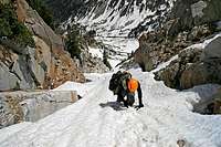
After a while you'll hit snow, which makes the ascent a breeze and removes most of the boulder hoping in Hogum Fork. On the west side of Hogum Fork you'll see two couloirs, the first and longest is The Needle and the second is the Sliver. Climb straight up the apron to the couloir. The apron starts at 30 degrees and increases to 45 degrees. The couloir proper is a constant 50 degrees for 1,100 feet. The couloir tops out on the summit ridge of North Thunder Mountain. From here, it is a short 3rd class scramble to the summit.
For descent, use either Coalpit Gulch or Bells Canyon. Coalpit Gulch funnels into a large waterfall at the base, which is nearly impossible to downclimb with the high runoff. A rappel rope would be mandatory. Even then, you would be rappeling through the waterfall over difficult terrain. We opted for a safer exit down Bells Canyon. We were able to glissade about half of the 6,000 vertical feet, then hiked down the trail to our shuttle car parked at the Bells Canyon trailhead (9400 S. and Wasatch Blvd.). Our total travel time was 12 hours (5am-5pm).![The Hypodermic Needle (a.k.a. The Needle)]()
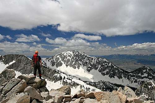
The summit.Helmet, crampons, ice axe. If desired, rock pro for the sides of the couloir, pickets, and a rope could be used for protection.
![The Hypodermic Needle (a.k.a. The Needle)]()
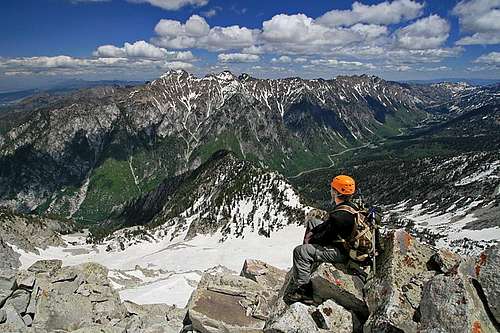
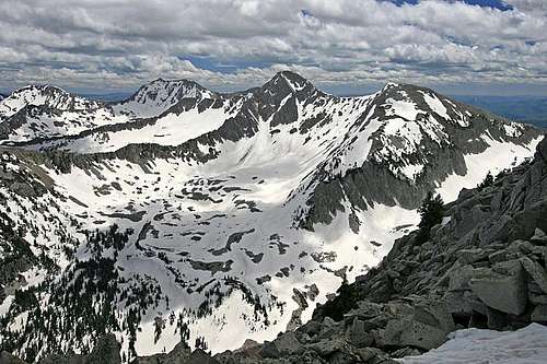
The view west.![The Hypodermic Needle (a.k.a. The Needle)]()
The view north.![The Hypodermic Needle (a.k.a. The Needle)]()
The view east.
NOTE: The Needle, and the entire east face of North Thunder Mountain, are avalanche prone during the months of winter snowpack conditions. The safest time for travel is usually mid May through early June. We climbed this couloir on June 6th and the snow was adequate for good climbing, although the top 50 vertical feet were melted out. The best snow conditions for climbing are probably found in mid May.
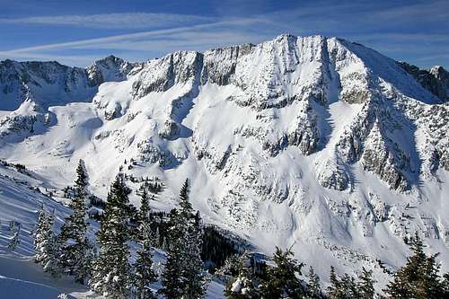
The Needle (right, in the shadow).
Getting There

The first log crossing.

The second log crossing.

Ascending Hogum Fork.
Hogum Fork Trailhead
Take I-15 to 9000 South Exit. Head east toward the mountains. Continue on 9000 South and you will wind through the city and eventually merge with 9400 South. The road will narrow into two lanes and travel through a few neighborhoods. As you approach Little Cottonwood Canyon, you'll hit the Y-intersection. You can recognize this intersection because of a large message board giving information about the canyon conditions.
Head up the canyon. Drive 1.9 miles and on your right hand side you will see a small powerhouse next to the canyon stream. The powerhouse is white and looks like a large shack. Continue past the powerhouse for another .5 miles and park in a large dirt parking lot on the right side of the highway. There is a wood sign in the middle of the parking lot that reads "Little Cottonwood Trail". You'll know you're at the right spot if the trail immediately travels downhill toward the Little Cottonwood stream.
White Pine Trailhead
Take I-15 to 9000 South. Go east (toward the mountains) on 9000 South. The road will travel toward the mountains and merge with 9400 South. Continue east. The road will diminish to a two-lane street and travel through residential areas. You will arrive at the mouth of Little Cottonwood Canyon. You will know you're at Little Cottonwood Canyon when you reach the Y-junction. At this intersection, you'll see a large information board that flashes updates about canyon road conditions. From here, go up the canyon roughly 5.3 miles to the White Pine Trailhead Parking Lot. When you are close to the parking lot, the road will widen with an extra passing lane. On the right side of the road you'll see a brown sign that reads "White Pine Trailhead Parking Lot."
There are bathrooms and some information boards at the parking lot. Follow the trail that travels behind the bathrooms. This trail leads to White Pine Canyon and Red Pine Canyon. After about a mile the trail will make an obvious split, take the right fork to head to Red Pine Canyon. Travel Red Pine Canyon into Maybird Gulch. Then from Maybird Gulch, enter Hogum Fork through the saddle below Pfeifferhorn's north ridge or by going up and over The Obelisk.
Route Description

Climbing the apron.

The meat of the couloir.
Looking down.
From the "Little Cottonwood Trail" sign in the dirt parking lot, travel downhill on the trail. When the terrain begins to flatten out, various forks in the trail will appear. Continue straight (due southeast) on the trail through the trees. After a short hike (3-5 minutes), the forest will open and you'll see forest service postmarks that say "No Camping". Just after these signs, the trail will turn east and parallel the canyon stream. Continue east for roughly 500 feet and turn directly south into the trees toward the canyon stream. You'll know you're in the right place if you have to cross shallow stream tributaries before you reach the bank of the large stream. Look for two large logs crossing over the stream. After crossing these logs, there is a second stream that is too deep to cross easily. Travel upstream (east) for another 200 feet and find another large log crossing the second stream.
After crossing the streams, bushwhack east until you reach the large stream flowing north out of Hogum Fork. Follow either side of the Hogum Fork stream as they are both reported to have moderate bushwhacking. Since you'll be traveling in spring conditions, there is very little groundcover and the bushes have yet to leaf, so finding the path of least resistance is easy. During our climb, we turned south into Hogum Fork too early, using a dry creek bed. We anticipated it would meet up with the large stream, but it never did. Instead, we bushwhacked through very steep and somewhat treacherous terrain into main Hogum Fork. Our route is not recommended, instead make sure you follow the large stream in Hogum Fork.
After a while you'll hit snow, which makes the ascent a breeze and removes most of the boulder hoping in Hogum Fork. On the west side of Hogum Fork you'll see two couloirs, the first and longest is The Needle and the second is the Sliver. Climb straight up the apron to the couloir. The apron starts at 30 degrees and increases to 45 degrees. The couloir proper is a constant 50 degrees for 1,100 feet. The couloir tops out on the summit ridge of North Thunder Mountain. From here, it is a short 3rd class scramble to the summit.
For descent, use either Coalpit Gulch or Bells Canyon. Coalpit Gulch funnels into a large waterfall at the base, which is nearly impossible to downclimb with the high runoff. A rappel rope would be mandatory. Even then, you would be rappeling through the waterfall over difficult terrain. We opted for a safer exit down Bells Canyon. We were able to glissade about half of the 6,000 vertical feet, then hiked down the trail to our shuttle car parked at the Bells Canyon trailhead (9400 S. and Wasatch Blvd.). Our total travel time was 12 hours (5am-5pm).
Essential Gear

The summit.
The view west.
The view north.
The view east.