|
|
Mountain/Rock |
|---|---|
|
|
45.70000°N / 112.63°W |
|
|
SilverBow |
|
|
Hiking, Trad Climbing, Aid Climbing, Scrambling |
|
|
Spring, Summer, Fall, Winter |
|
|
7000 ft / 2134 m |
|
|
Overview
At just over 600 ft. tall, the wedge sits as the Crown Jewell of the Humbug Spires Primitive Study Area. Its gleaming white granite is probably the densest and finest grained of all the Boulder batholith stone. The vertical cracks and challenging roof systems that make up the Eye of the Cyclops combine to make this one of the premier climbing areas in a state that has so many quality destinations.Traditional moderate routes dominate the main S.W. and S.E. Faces, while the newer routes tend to be more difficult, and have been put up on the past vertical walls of the N. Face by such luminary climbers as Kurt Krueger and Dwight Bishop.
The climbing on the Wedge is storied, with a rich history of some of the finest climbers in the state leaving their mark in the form of classic routes. Unfortunately much of this history has died with the first ascendants who failed to publish their accomplishments. Fred and I are attempting to gather as much of this early history as possible, and we hope to include it here on summitpost.
While there is potential for new route development on the wedge, it is highly likely that most of the obvious lines have been climbed by someone over the years, and have just not made it into the guide books. Aesthetic position on impeccable rock in a pristine environment characterise the climbing on the Wedge. May your days spent climbing here be plentiful.
Getting There
The humbug spires are accessed via I-15, at the Moose creek exit #99. About 24 miles South of the I-90 interchange, and 39 miles North of Dillon. Follow the improved and graded Moose creek Road for 3 miles to the trial head,Follow the new trail along Moose creek for 1.5 miles where the trail leaves the creek, stay on the well beaten path, and begin a gradual ascent to a new series of switchbacks that gain the upper ridge. Many guide books mention a junction at the 1.5 mile mark, but with the construction of the new trail this information is obsolete. Continue along passing an old set of water entrapment dams, and on to an old homestead cabin. I use the word cabin loosely as there is no longer any roof structure, and many of the logs of the walls have fallen. Cross a spring of fresh water [filter or treat to use], and begin the last steeper ascent to the base of The Wedge, about 4 miles total distance.
Red Tape
There are no fees or permits required to recreate in the Humbug Spires Primitive Study Area. This area however is managed as a defacto wilderness area by the BLM, so there is no mechanized usage allowed . This includes mountain bikes, and power drills.Camping in one spot is limited to 14 days.
When To Climb
This Area can be accessed year round, with some very nice warm spring and fall days to make for pleasant climbing.Summer can be hot a buggy, so bring your bug spray and get on the rock early in the am.
Winter can be extremely cold, the coldest spots in MT are only a few miles away, and they regularly report lows in the -30 deg. range. If you choose to ski back in, have your stuff in a group, and be fully self supporting in case of emergency.
Camping
See the main Humbug Spires page for detailed camping options.Routes
Some of the developed routes not yet included on summitpost are;Eagle Dance, 5.11b, 5 pitches.
Tiny Tim, 5.10c 3 pitches that joins with the Mutt and Jeff to summit.
Scrooge, 5.10b 3 pitches that join with the Mutt and Jeff also.
West Face, 5.9+ 3 pitches that also join the Mutt and Jeff.
West Face Direct, 5.9+ single pitch variant to the first pitch of the West Face.
Dogleg Crack, 5.11a a first pitch variation to either the Mutt and Jeff, or the S.W. Face.
Bovine Intervention, 5.10 a last pitch variant of the S.W.Face.
Balcony Direct, 5.9 2 pitch , continues to S.E Chimney.
Gandalf, 510cR 2 pitch.
Exit 99 Variant, 5.8 4 pitches to summit


gato - Aug 27, 2004 2:18 pm - Voted 10/10
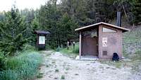
Untitled CommentTrailhead is on the left of the road, not the right (as I wrote earlier). It is quite apparent, though, when you drive up to it. Big wooden sign, nice Forest Service toilet building, parking area.
gato - Aug 26, 2004 6:49 pm - Voted 10/10
Untitled CommentFrom Butte, drive south on Interstate 15 approx 20 miles. You will come to Moose Creek, a "no-services" exit. This is well before Dillon.
Exit at Moose Creek, and follow the good (by Montana standards) dirt road generally east and somewhat north to the trailhead for Humbug Spires. The trailhead is on the right, and the road does continue on, so make sure you stop at the right spot. Roughly 6 miles from the interstate (I think, I can't remember from the last time I was out there). Park at the trailhead, which offers topos of the area and a pit toilet.
Hike up the trail for about 4 miles. The description on this page takes it from there.
gato - Aug 27, 2004 2:18 pm - Voted 10/10
Untitled CommentTrailhead is on the left of the road, not the right (as I wrote earlier). It is quite apparent, though, when you drive up to it. Big wooden sign, nice Forest Service toilet building, parking area.