
-
 4708 Hits
-
 72.08% Score
-
 2 Votes
|
|
Route |
|---|---|
|
|
46.26018°N / 13.75694°E |
|
|
Hiking |
|
|
Summer, Fall |
|
|
Half a day |
|
|
Easy (a bit steep) hike |
|
|
Rating The Tour (By Hiking Standards)
Tolminske Ravne
0. General. From 940 m to 2085 m, exposition S and W. Below first a broad shepherds path and mule track, above Kal meadow a comfortable, on some places steep mule track. Over the high plateau and on top a pathless terrain, but easy. By the Swiss (SAC) Hiking Scale the rating would be T2. Gear (in dry seasons): Only good shoes and poles.
1. Effort. 1150 m, 3 h 30 min.
2. Power. 1 - no difficulties, only walk-up.
3. Psyche. 2 - easy (some care is needed on a few steep passages).
4. Orientation. 2 - easy. Only on the summit plateau carefully follow ciarns. The grading system for hiking and scrambling routes is here.
Overview
This is a summer, not marked route which from the beautiful Kal alpine meadow first directly ascends the summit ridge of Tolminski Migovec, 1881 m, and then over the high karst plateau goes towards the north directly on the summit of Tolminski Kuk. From Tolminske Ravne, which is the usual trailhead for the highest summits in South Bohinj Range, this is the fastest ascent route to Tolminski Kuk. The highlights of the tour are: the charming Kal alpine meadow, the beautiful path up on the high plateau and the immense summit panorama. A round tour is recommended - the marked return can go over Razor alpine meadow.
Getting There
See the parent page of Tolminski Kuk how to reach Tolminske Ravne village (From Tolmin, via Žabče)!
Route Description
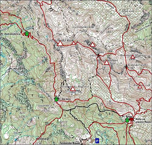
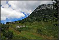
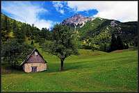
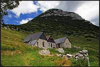
The trailhead for Kal alpine meadow is the same as for Razor meadow - at the house by the road where Slovenian mountaineering association has the Rescuing service info point. Through the gate you go on a nice alpine meadow and cross it northwards. After exiting the meadow on the other side, you continue left along its edge to the crossroads, where the marked path for Razor meadow goes right. Our cart-road continues towards the NW, all the time through nice beech woods. In comfortable turns the path gains altitude. Whenever in doubts because of other paths, allways keep on the broadest and most beaten one. After an hour the path reaches the other one, which crosses the slopes of Tolminski Migovec. The inscription towards the right directs you on Razor meadow, but we go of course left, first crossing the slope, then ascenting in turns again. A part of the broad path can be cut by a shortcut. Above, we are already close to the meadow, in a few turns we reach the cute three huts (Kal) close to the saddle, 1490 m. The broad view towards the west opens from the saddle - the whole Krn group is rising across Tolminka valley.
 |
 |
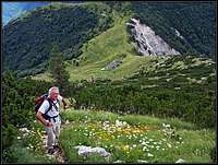
Above Kal
From Kal one marked path crosses the slopes towards Razor meadow, the other one continues towards the NW. But we go directly upwards, by a good, but not marked path in the direction of Migovec summit. After a few turns the path starts going left around the mountain. It crosses the western slopes of Tolminski Migovec, allways ascending by nice, broad grasy ledges. On a few places it goes up on a higher level and then continues crossing. In some 45 minutes we are below the NW summit ridge, the path reaches it on a rocky passage. From the ridge it is well worth going immediately on the summit of Tolminski Migovec. The well beaten path goes towards the right, first almost horizontally, then some 50 meters up on the panoramic summit, 1881 m.
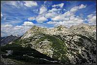 Tolminski Kuk from Migovec |
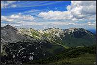 South Bohinj Range |
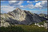 Vrh nad Škrbino |
On Tolminski Kuk
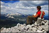
To ascend Tolminski Kuk we first go by the ridge back to the crossroads and then in the N-NW direction over the high karst plateau. There is a tiny path which later gets lost, but we can follow cairns. If visibility is good, we see Tolminski Kuk clearly ahead of us (the last high summit on the left), so there's no problem with orientation. On the plateau speleologists may have a summer camp, exploring the interesting karst phaenomena there. Nature on the plateau is really beautiful. In July I had an impression that the prevailing flower on those meadows is edelweiss! After reaching the summit slope, we best go directly towards the highest point. We may reach the summit ridge a bit east of the summit and then continue a few more minutes westwards on top.
The fastest descent goes by the same route, but if we descend towards Razor alpine meadow, we can all the time follow marked paths. They lead us first over Zeleni vrh, 2052 m, then below Podrta gora, 2061 m, and from Škrbina notch below the famous southern slopes of Vrh nad Škrbino to Razor meadow. You should count good two hours for this descent and one hour more down to the parking place.