Toggle navigation
Mountains
Routes
Images
Trip Reports
Forum
What's New
People
Areas & Ranges
Articles
Trailheads
Canyons
Huts & Campgrounds
Albums
Logistical Centers
Fact Sheets
Lists
Custom Objects
Gear
Plans & Partners
WELCOME TO SUMMITPOST
SIGN IN
REGISTER
Schofield Peak
Additional Parents
Route from Otter Lake
Image
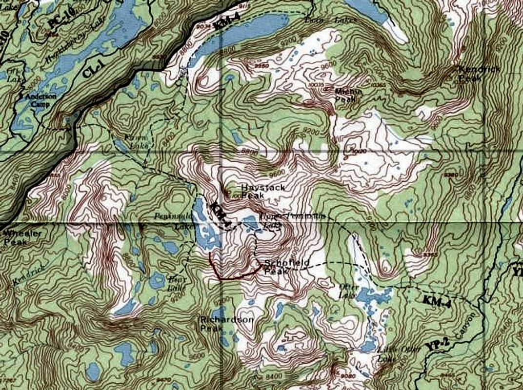
Topo map shows the following...
View High-Resolution Image
Topo map shows the following...
Topo map shows the following routes.
From Upper Peninsula Lake to Schofield Peak via the south ridge.
From Peninsula Lake to Schofield Lake via the western ridge (red line).
From Otter Lake to Schofield Peak.
From Upper Peninsula Lake to Haystack Peak.
From Otter Lake to Haystack Peak.
« PREV
NEXT »
Alpinist
on
Oct 31, 2003 10:52 pm
Comments & voting
Other parents
Lat/Lon:
38.09400°N / 119.677°W
Image ID:
32028
3751 Hits
74.01
% Score
4
Votes
Log in to vote
Comments
No comments posted yet.
to post!
Don't have an account?
Schofield Peak
(Mountain/Rock)
You are at
the First
Image
Viewing
#1 of 1
GALLERY
You are at
the Last
Image
Alpinist's Image Gallery
« PREV
Viewing
#304 of 662
GALLERY
NEXT »
Route from Otter Lake
(Route)
Loading....
×
You need to login in order to vote!
User Name
Password
Remember me
Forgot your password?
Log me out when I close my browser.
Keep me logged in all the time.
sign in as a user
Don't have an account?
Register now for FREE
Rating available
Suggested routes for you
People who climb the same things as you
Comments Available
Create Albums
Register Here


