
Introduction:
My plan for this page it to gather detailed Topographic Maps of all the the California 14ers (and now adding 13ers as well). These are downloaded USGS maps in drg format with elevation (dem) overlays. I use a program called Global Mapper. The ones I have climbed have GPS Track overlays.I download the drg USGS Maps from the following website in .tiff format.
http://casil.ucdavis.edu/mapsurfer/
And I download the elevation data from the following website in DEM.SDTS.TAR.GZ format.
http://data.geocomm.com/catalog/US/61069/1398/group4-3.html
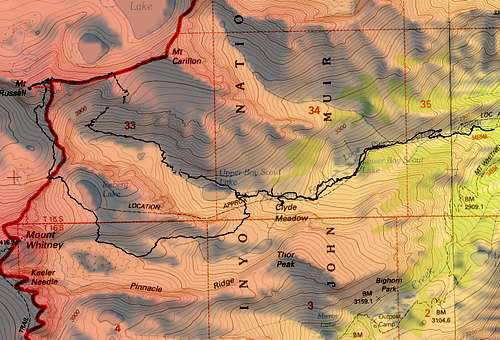
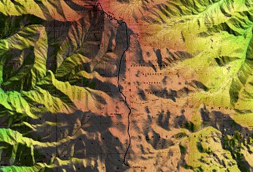
Mount Whitney & Muir

Mount Russell
Mount Langley

White Mountain
Split Mountain

Thunderbolt Peak, Starlight Peak, North Palisade, Polemonium Peak, Mount Sill & Middle Palisade

Mount Tyndal & Williamson

Dragon Peak, Mount Gould and University Peak

Whorl Mountain and Matterhorn Peak
 Matterhorn and Whorl
List of Easiest to Hardest 14ers
I gathered some information from The Whitney Portal Store Bulletin Board on a general listing of easiest to hardest 14ers with some trip information. The results are below:Posted September 08, 2006 04:45 PM
After about four years, I finally finished climbing all the fourteers this summer. Below is my list of what I felt was the easiest to hardest fourteeners.
1. White Mountain, hands down. You can take a mountain bike to the top and have a fun ride down. This mountain is a good way to get introduced to altitude. For a beginner I’d suggest spending one day at or around the bristlecone pine forest first. Camp somewhere around 11,000 to 12,000 and start at a decent time on the second day. I threw up once on the way to the top… (2x - Summer and Spring)
2. Langley is a long walk, but you do not gain much altitude along the way since the trailhead is so high. If you are in shape, it is pretty easy. The camp spots by the last lake are real nice! (1x - Summer)
3. Split Mountain seemed pretty easy to me. There are some spots with no real clear trail and a tad bit of exposure, but nothing too frightening. The hardest part was getting to the trailhead. (1x - Summer)
4. Mt. Whitney (Main Trail/Mountaineers Route/East Face) – in the summer, after getting through the mess called the permit system, this is a pretty easy hike. Just walk up the trail. The Mountaineers route is a good bit harder but more fun. Snow makes everything much harder. (4x – Spring, Summer, Fall and Winter)
5. Mt. Tyndall has a bit of exposure pretty much the entire way (above 12,000), but since I rock climb I was pretty comfortable with it. Also, it is a damn long walk up the Shepard’s pass trailhead – that was probably the hardest part. Really pretty area though! (1x - Summer)
6. Mt. Muir is easy to miss on the way up to Whitney, but it is a fun little peak. I think for most people, it would be easier than Tyndall, but I did it in January and it was very cold with somewhat icy conditions. (1x - Winter)
7. Mt. Russell was one of my favorite fourteeners. I did the 3rd/4th class East Ridge route and it really was fantastic. There is some incredible exposure along the way, but the route felt quite secure. After climbing Russell, we had day light to spare, so we ran up the Mountaineer’s Route on Whitney for fun. (1x - Summer)
8. Polemonium Peak – I climbed this from the West Side via Bishop Pass (U-Notch) on the way up to North Palisades. It was not real difficult, but not real easy to get to either. Any peak in the Palisades involves true climbing. (1x - Summer)
9. Mt. Shasta was lots of fun for me because I am a backcountry skier. On the way down, I was able to ski from about 13,000 to the car. It was so much fun flying past all the snowshoers struggling in the wet snow Shasta in the winter is not technical, but one MUST know how to use an ice axe and crampons. Two people slid down the same route I went up on the day I summated because they didn’t know what they were doing. I personally saw one slide by me. A second person ended up with a broken ankle from the crampon catching on the ice. It shouldn’t have happened… (1x - Winter)
10. North Palisades was a lot of fun. I did this on the same trip as Polemonium. If I remember right, it involved two roped pitches and some scrambling on top. It wasn’t overly hard, but there is no way around the 5th class section. (1x - Summer)
11. Mt. Sill – I climbed this peak via the Swiss Arete, a climb rated 5.6. It was pretty easy and in fact, my friend and I accidentally free-soloed a good share of the climb before we realized it and ended up doing only three pitches. The hardest part was again getting to the base of the climb (and the descent after the climb). You get to cross a glacier and go through a messy gully. But, once on the mountain, it is really nice. (1x - Summer)
12. Middle Palisades is evidentially not too hard for those who do it in the summer after the snow in the chute melts, but I had to go try it in the early spring. We had lots of new snow, waist deep in many places almost the whole way up. We ended up climbing through 5th class sections unroped to stay out of the deep wet snow. On the way down I was very happy to have packed a 50 meter 8 mm half rope and a bunch of hand tied slings. There were some frightening moments! (1x – Spring)
13. Thunderbolt Peak getting almost to the top of Thunderbolt peak isn’t too hard. You walk 8 miles from Bishop Pass, head up a long gully full of lose stones and boulders then you go through a small 5th class section to get to the summit block. That is when things get interesting. (1x – Summer)
14. Starlight Peak is very similar to Thunderbolt. First, walk 8 miles from Bishop Pass, then head up a long gully full of lose stones and boulders until you get to the summit block. It is called the Milk Bottle. On the top, you will experience significant exposure. You will probably be scared. (1x – Summer)
15. Williamson was my hardest climb. I attempted it three times before I summated it via the South Fork of Bair’s creek. On that route there are a few sections that travel up a snow chute that are quite steep and exposed. My first attempt was spent in the nastiest brush choked valley/gully that I had ever seen. Some German guy who was too cheap to buy a map recommended it to a friend as a good route. We later learned that he was lost and meant the South Fork of Bair’s creek. Make sure you do your homework, especially on a mountain like this that really doesn’t have any trails. (1x – Spring)
Routes, mileage, elevation and class rating
Source: Whitney Portal Store Bulletin BoardIf you can help fill in any question marks below please add a comment. Thanks,
Here's a quick list of what I found in the CA 14'rs book by Porcella and Burns, with elevation gain and mileage added in where I know too. I'd be interested in hearing people comments on the harder peaks, as well as mileages, elevation gain, and time for some of the harder 14'rs in the Palisade Region.
1. White Mountain - 14 miles RT - Class 1 - ~2000+ feet elevation gain
2. Mt. Langley - ~21 miles RT - Class 1 - ~4000+ feet elevation gain
3. Mt. Whitney - 22 miles RT - Class 1 - ~6000+ feet Elevation gain
4. Mt. Muir - 20 miles RT - Class 3 (from the Main Mt. Whitney Trail) - ~6,000 feet elevation gain
5. Split Mountain - ~18 miles RT - Class 2/3 - ~7500 elevation gain - North Ridge Route via Red Lake
6. Mt. Russel - ~15miles RT - Class3/4 - ~5500 feet elevation gain - East Ridge Route
7. Mt. Tyndall - ~25 miles RT - Class 2 ~8500 feet elevation gain
8. Mt. Williamson - ~27 miles RT - Class 2 w/ 1 short section of Class 3 - ~8500 elevation gain NOT INCLUDING the ups and downs of the Williamson Bowl - West Face
9. Middle Palisade - ~14 miles RT - Class 3 - ~6000 ft Elevation Gain - East Face
10. Mt. Sill - ? miles RT - Class 3 - ? Elevation Gain - East Couliour
11. Thunderbolt Peak - ? miles RT - Class 3 - ? Elevation Gain - SW Chute #1
12. Polemonium Peak - ? miles round trip - Class 3/4 - ? Elevation Gain - Southeast Ridge - (I think this might be the rating on the traverse f/ Mt. Sill??? Have to check)
13. Starlight Peak - ? miles RT - Class 4 - ? elevation gain - Starlight Buttress - True summit has the infamous "Milk Bottle," which is rated 5.4 - also done as a traverse f/ North Pal
14. North Palisade - ?miles RT - Class 4 - ? elevation gain - U Notch Southwest Side - I've talked with people who've done North Palisade and said they wouldn't take a rope the next time they'd do it, but I wouldn't touch any route on that monster without a climbing rope and a small rack!
15. Mt. Shasta - 14 miles RT - Class 3 - 7000 feet elevation gain - Avalanche Gulch - Although I've read somewhere that Shasta has easier routes, I've included Avi Gulch because it seems to be the most popular route to the top. I don't think Shasta is the hardest fourteener, but it's really in a class by itself because it's the only mandatory snow climb, whereas all other 14'rs have rock alternatives.
I'm curious to hear what others' experiences have been on the Palisade Region 14'rs as I don't have any experience on those just yet. Time frames, benefits to starting/camping spots, best to do in a day, etc.
Lastly, it's a bit difficult to put them in order from "easiest to hardest" because it depends on what you're talking about as far as difficulty. If you're talking about Class ratings, then I guess Starlight or North Pal would take the cake. If we're talking about overall distance and elevation gain, then Williamson would probably have it.