
|
|
Route |
|---|---|
|
|
29.00281°N / 90.23569°E |
|
|
Mountaineering |
|
|
Spring, Fall, Winter |
|
|
Expedition |
|
|
F-PD (high altitude glacier route) |
|
|
Overview
The 2.5km long ridge between the two summits of Unnamed Peak 6161m and Mt. Qunyang (6121m) represents an extremely scenic and technically easy traverse. The altitude along the crest never drops below 5900m, and there are stunning views on the nearby Noijin Kangsang, Kaluxung, as well as the more distant Nyenchen Tanglha range to the north and the Bhutan/Tibet Himalaya to the south.Though the ridge is absent of technical difficulties, the northern side of the mountains has several treacherous crevasses. The ridge is also quite exposed to the strong winds that use to sweep the whole area.
The present page describes the route in a west-east direction, but the traverse can also be made in the opposite direction, or with some alternative detour in the north side (as I did).
The following two pictures give a good overview on the whole traverse, seen from the west (left picture) and from the east (right picture):
 Mt Qunyang 6121m Mt Qunyang 6121m seen from Unnamed Peak 6161m | 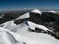 Unnamed Peak 6161m Unnamed Peak 6161m seen from Mt. Qunyang |
Getting There
See the main mountain page, getting there section for the approach to the peak via Lhasa or via Shigatse.Route Description
The starting point is the summit of Unnamed Peak 6161m, which can be reached via the South Route.From the summit, return on your track to the saddle along the ridge to the saddle located at 6059m (see GPS waypoints below). There is a small climb on a hard cornice just east of the saddle.
An alternative option is to descend from the summit directly in the heavily glaciated north side of the mountain, in order to avoid the 20-30m climb after the saddle. This is the way I choose, but it resulted much more tiring, as I found deep unconsolidated snow, with some well hidden crevasses. It is advisable to take a rope if you chose this option.
 1. Summit ridge of P6161m 1. Summit ridge of P6161m Seen from the saddle at 6059m |  2. Option 1: follow the ridge 2. Option 1: follow the ridge Cornice seen from the saddle at 6059m |  3. Option 2: north side 3. Option 2: north sideBeware of the deep snow and hidden crevasses |
Both ways join again on the ridge, and then it is again a straight walk on the ridge down to the col at 5959m, which is the lowest point of the traverse. From the col, climb the easy slopes of the summit dome of Mt. Qunyang (map 6121m, GPS 6130m).
 4. Looking back near Col 5959m 4. Looking back near Col 5959m The tracks are clearly visible on the route chosen |  5. Peak 6161m 5. Peak 6161m With col 5959m in the foreground |  6. Mt. Qunyang Summit (6121m) 6. Mt. Qunyang Summit (6121m)With Mt. Quigu 6212m (left) and Mt Naji Kangsha 6106m (right) in the background |
From the summit, you can either follow the southwest ridge route, or continue on the southeast ridge until the foresummit (P6054 on the map), and then south on the loose scree until you reach again the main Nganyang valley at around 5400m (confluent at P5374 on the map).
 7. Nganyang valley 7. Nganyang valley Looking south from an altitude of approx. 5900m |  8. Campsite at 5285m 8. Campsite at 5285m Back to the camp in a wonderful late autumn atmosphere |
Panorama from the summit
Both summits offer a very fine 360° views:- To the South: fantastic views on the 6000ers on the south side of Karo La (Kaluxung 6674, Jangsunglhomo 6325, etc.)
- To the Southwest: Noijin Kangsang (7206m) north ridge and northeast face
- To the Northwest: Enigmatic Mt. Lungba (6151m, probably still unclimbed) and distant Mt. Qingmo Kangri (7048m)
- To the East: Lake Yamdrok Yumtso and holy mountain Mt. Yarla Shampo (6636m), still unclimbed
- To the Southeast: nearby Mt. Qigu (6212m), Mt. Naji Kangsha (6106m) and Mt. Menjiu Zhari (6110m)
A 180° panorama from the summit of Mt Qunyang has been posted on the main mountain page.
Essential Gear
Camping equipment, crampons, ice axe and appropriate clothing for a 6000ers are essentials.GPS Waypoints
P6161m: Lat. 29°00'11.30"N Long 90°12'46.70"E Summit Unnamed Peak 6161mP6059m: Lat. 29°00'11.10"N Long 90°12'57.40"E Saddle 6059m
P5959m: Lat. 29°00'18.80"N Long 90°13'40.60"E Col 5959m
P6130m: Lat. 29°00'10.01"N Long 90°14'08.50"E Summit Mt Qunyang (map 6121m)
P5376m: Lat. 28°58'48.20"N Long 90°14'18.20"E Campsite (near P5374m, map)
P5285m: Lat. 28°58'22.60"N Long 90°14'13.50"E Campsite (above P5241m, map)
Map
 Extract from the NK map, with Peak 6161m and Mt. Qunyang 6121m.
Common approach to the possible campsites in marked in blue
South route to Peak 6161m in red
Traverse Peak 6161 - Mt. Qunyang in yellow
Mt Qunyang Southwest ridge in green