
|
|
Mountain/Rock |
|---|---|
|
|
29.00314°N / 90.21297°E |
|
|
Mountaineering |
|
|
Spring, Fall, Winter |
|
|
20213 ft / 6161 m |
|
|
Overview
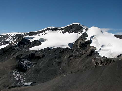
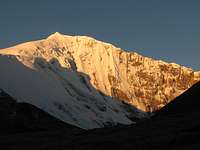
 Northern slopes of Unnamed Peak 6161m
Nestled at the far end of the Nganyang valley in Central Tibet, the Unnamed Peak 6161m and its neighbour Mt. Qunyang (6121m) are two unknown 6000ers located near the giant Noijin Kangsang.
Both peaks belong to the eastern part of the Lhagoi Kangri belt or North Himalaya range, and are easily accessed via the Karo La pass on the Nagartse-Gyantse road. The area around Noijin Kangsang counts no less than twenty three (!) summit above 6’000m (with a prominence of at least 100m / 330ft), several of them still unclimbed.
Due to the total absence of information available, it is not known whether the two peaks had been previously climbed before a successful solo ascent of both summits in October 2007. The ascent of Mt. Qunyang was repeated in the winter 2007-2008 via an alternative route.
Unnamed Peak 6161m and Mt. Qunyang (6121m) are presented in the same page for obvious reasons: same area, same access, same base camp, same technical difficulty and both summits can be reached in the same day…
Three routes are described in the attached pages:the south route for Peak 6161m, the southwest ridge for Mt. Qunyang, as well as the traverse between the two summits.
Thanks to their proximity with 7206m high Noijin Kangsang, Unnamed Peak 6161m and Mt. Qunyang (6121m) represent an ideal acclimatizing target. For fit climbers, it is possible to summit both peaks from Noijin Kangsang base camp and return back in a same day.
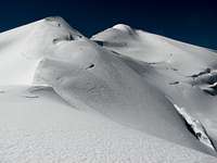
Except some hidden crevasses on the heavily glaciated north side, the two peaks do not present objective dangers and are technically easy. They can be ascended without rope by experienced climbers or can be an ideal training ground for beginners. However, you are moving above 6’000m or 20’000ft, so beware of altitude if you are not acclimatised!
 | 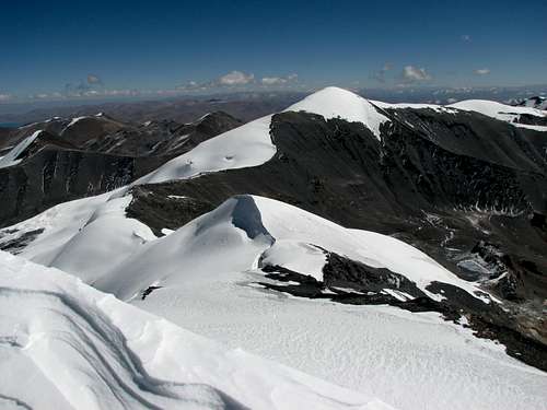 |
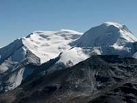
seen from Mt. Qunyang (looking East) Altitude: 6’161m / 20’213ft Prominence: 200m / 650ft Latitude: 29°00'11.3"N Longitude: 90°12'46.7"E | seen from Unnamed Peak (looking West) Altitude: 6’121m / 20’082ft Prominence: 170m / 560ft Latitude: 29°00'10.0"N Longitude: 90°14'08.5"E |
Getting There
See Red Tape section for travel restrictions in Tibet.From mainland China to Tibet:
See the Noijin Kangsang page for a detailed description on the different routes into Tibet.
From Lhasa to the mountain
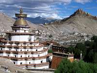
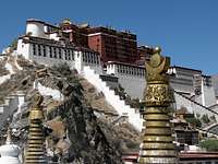 Lhasa LhasaPotala palace | 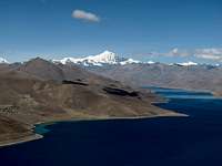 Gampa La Gampa LaYamdrok Yumtso with Noijin Kangsang |  Turn off into Nganyang valley Turn off into Nganyang valleySharp 6300m face in the Kaluxung massif |
Mt Qunyang is located around 185km south-west from Lhasa, near the main road between Nagartse and Gyantse. You can hire a vehicle in Lhasa (Landcruiser is not needed) or take a bus from Lhasa to Nagartse, and then from Nagartse to Gyantse.
The last stretch has been asphalted at the end of 2007, shortening the travel to about three to four hours. Leaving from Lhasa, the road first crosses Yarlung Tsangpo River (Brahmaputra), before climbing Gampa La (4800m), where there are fine views on Yamdrok Yumtso lake and the Karo La group in the background. Noijin Kangsang is the highest peak rising above the lake, while Mt. Qunyung is located on the right of it.
After passing the small town of Nagartse (several hotels and restaurants), continue further up towards Karo La (5'036m). 19 km after Nagartse, the Nganyang side valley will open to your right. Leave the main road at the turnoff and continue north for about 4-5km on a small motorable track. Stop at the end of the road (map P4879m) near the small Kangbu lamasery.
Approach via Shigatse
An approach from Shigatse through Gyantse is also possible, and is worth to be considered if you have just arrived in Lhasa and need a few more days for acclimation. In that case, stop 9km after Karo La on your way down to Nagartse. Total distance From Shigatse to Karo La is 165km.
 Gyantse GyantseLast town on the way to Karo La |  View from Simi La (4360m) View from Simi La (4360m)Turquoise lake on the road |  Noijin Kangsang west face Noijin Kangsang west face Approaching Karo La |
Red Tape
Regulations for entering and travelling within Tibet are changing rapidly, so check on travellers' websites for updated information.To enter and travel within Tibet:
Foreigners need the following documents to enter and travel within Tibet:
Tibet Entry Permit (issued by Tibet Tourism Bureau)
Tibet Entry Permit is usually requested when you buy a train or flight ticket. Local travel agencies in Beijing or Kathmandu can arrange in a few days your Tibet Entry Permit together with your train/plane ticket to Lhasa.
Alien Travel Permit (issued by Public Security Bureau – PSB)
Lhasa and Shigatse cities, as well as a few tourist spots around Lhasa have been declared open to foreigners, so that you don't need any additional permit anymore. However, as soon as you want to move into areas closed to foreigners, you need an Alien Travel Permit (ATP), which lists the places where you will be allowed to travel. Cost of an ATP is 50 RMB.
Climbing Permit (issue by China Tibet Mountaineering Association – CTMA)
Due to the current travel restrictions in Tibet, most peaks are usually proposed within a package including transportation and logistics by China Tibet Mountaineering Association (CTMA). The lump sum varies depending on the number of climbers, and bargain is possible depending on the service level you require.
Contact CTMA at the following address:
China Tibet Mountaineering Association
No 8 East Linkhor Road
Lhasa, Xizang/Tibet, China
Tel: +86-891- 6333687
fax:+ 86-891- 6336366
e-mail: ctma@public.ls.xz.cn
Camping and accommodation
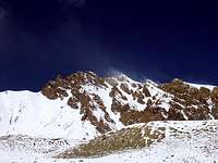
 Unnamed Peak 6161m
from above camp 5285m
Cheap hotels and restaurants can be found in Nagartse, 20km away from the road end.
The are plenty of beautiful campsites along the Ngranyang valley, which are suitable as base camps to attempt the two peaks. The higher you camp, the shorter your summit day will be. Here below the coordinates of possible campsites:
P5330m: Lat 28°58'10”N Long 90°13'23"E (Noijin Kangsang BC near Gama Lake)
P5285m: Lat 28°58'22.60"N Long 90°14'13.50"E (P5241m on the map, confluent Gama-Nganyang)
P5376m: Lat 28°58'48.20"N Long 90°14'18.20"E (in the Nganyang valley, spring nearby)
Then all along the valley up to the (usually) frozen lake at P5650m
P5650m: Lat 28°59'42"N Long 90°13'33"E (lake located between Peak 6161m and Mt. Qunyung)
There is plenty of water available, but in winter you’ll have to melt ice unless you find some unfrozen springs or resurgence in the river. A small perennial resurgence can be found near camp 5376m at Lat 28°58'49.80"N Long. 90°14'13.20"E.
When to climb
Spring (End of March till beginning of June) and autumn (End of September till beginning of November) are the best seasons to climb in the area. Winter climb is also possible, but you will need very warm equipment, as temperatures drop easily below 20°C at base camp altitude.Winds are usually stronger in later winter and spring than in autumn. Weather is instable during the summer rainy season (monsoon).
The following pictures show how drastically the conditions can change…
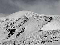
 Peak 6161m on 24 Oct 2007 Peak 6161m on 24 Oct 2007 |  Peak 6161m on 20 Feb 2008 Peak 6161m on 20 Feb 2008 |
 Camp 5285m in late October: Camp 5285m in late October:back from the summit in the warm afternoon! |  Camp 5376m in February: Camp 5376m in February:A freezing night in perspective… |
Routes and difficulty
Three routes are described in the attached pages: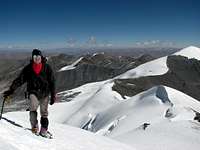
All three routes have the same approach via the Nganyang valley: at the turn off around 9km below Karo La (altitude 4720m), head north into the Nganyang valley for about 4.5km on a small motorable track until you reach the small Kangbu Lamasery (map P4879m), located near the perched Kangbu glacier lake (5124m). The site offers impressive view on Noijin Kangsang East face.
Follow the Nganyang valley upstream for another 2.5km, until you reach the confluent leading to Naji Kangsha (P5084m on the map). Continue heading north in the main valley for another 2.5km, up to the next confluent (P5241m on the map). You can either camp here (see above the coordinates for camp 5285m), where there is an exceptional view of Noijin Kangsang NE face, as well as Mt. Mengjiu Zhari, or continue upstream for another 1km until you reach camp 5376m (see coordinates above), where Peak 6161m becomes fully visible. The valley broadens and offers plenty of additional campsites on the next two km until the small glacier lake at P5650m. Total distance from the turn off on the main road up to P5650m is approximately 12.5km.
Cimbing from the north is possible, but this would require a completely different approach either via Rinpung (on the Friendship Highway Lhasa- Kathmandu) or via the village of Pelde Dzong on the shores of Yamdrok Yumtso. The north side is heavily glaciated with many treacherous crevasses, so progressing with a rope is a must!
Panorama
Both summits offer a very fine 360° views:- To the South: fantastic views on the 6000ers on the south side of Karo La (Kaluxung 6674, Jangsunglhomo 6325, etc.)
- To the Southwest: Noijin Kangsang (7206m) north ridge and northeast face
- To the Northwest: Enigmatic Mt. Lungba (6151m, probably still unclimbed) and distant Mt. Qingmo Kangri (7048m)
- To the East: Lake Yamdrok Yumtso and holy mountain Mt. Yarla Shampo (6636m), still unclimbed
- To the Southeast: nearby Mt. Qigu (6212m), Mt. Naji Kangsha (6106m) and Mt. Menjiu Zhari (6110m)
The following picture shows a 180° panorama taken just below the summit of Mt. Qunyang. Use the horizontal scrollbar to navigate through the panorama (left = south, centre = west, right = north). For a full size picture of the panorama (15530 x 1470 pixels), click here
  |
Maps
Google Earth is a precious tool to plan an expedition to the Lhagoi Kangri range, and can almost replace a map: mark some GPS reference points and print a few images beforehand!The Lhanzhou Institute of Glaciology and Geocryology has produced an excellent 1:50'000 map of Noijin Kangsang area, which includes Mt. Qunyang (altitude according to the map 6121m, GPS measurement 6130m) and neighbouring peaks. The map is published by Xi’An Cartographic Publishing House (1997), and exists in both Chinese and English versions. Unfortunately, the map is not distributed anymore within China (due to lack of sales, according to the publisher), so posting it on Internet is rather a service than a copyright violation…
Abroad, it may still be possible to order the map online at themapsho.co.uk or at mapsworldwide.com.
 Extract from the NK map, with Peak 6161m and Mt. Qunyang 6121m.
Common approach to the possible campsites in marked in blue
South route to Peak 6161m in red
Traverse Peak 6161 - Mt. Qunyang in yellow
Mt Qunyang Southwest ridge in green
Trekking and other climbs in the area
There are plenty beautiful trekking possibility around Karo La, as well as glacier climbs over 6'000m. See the Lhagoi Kangri area/range page for more information.The following peaks in the area have their own page on SP:

External links
Qinghai-Tibet Train Official WebsiteLhasa travel guide