
-
 22302 Hits
-
 86.37% Score
-
 22 Votes
|
|
Mountain/Rock |
|---|---|
|
|
36.66057°N / 105.9827°W |
|
|
Taos |
|
|
Hiking, Trad Climbing, Sport Climbing, Toprope, Bouldering, Scrambling |
|
|
Spring, Summer, Fall, Winter |
|
|
8420 ft / 2566 m |
|
|
Overview
 San Antonio Mountain looms beyond the Sundeck Wall
The sleepy little town of Tres Piedras, 30 miles northeast of Taos in northern New Mexico, is notable primarily because it is the intersection Highways 285 and 64. A few art adventurers make it to the big pink schoolhouse, which serves as home and gallery to the town’s most noteworthy artist. Fewer still come to climb the town’s excellent namesake crags. Known affectionately as the "TP Rocks", it is unclear which three rocks lent their name to the town, for there are actually four or five clusters of granite outcroppings, but the majority of interest will be focused on the largest and northernmost group of rocks. Here one will find one of northern New Mexico’s best climbing destinations. Composed of excellent granite, the crags’ offerings range from difficult, multi-pitch climbing to great hiking and scrambling.
Although the mighty San Juan Mountains are iconic of the Colorado Rockies, the range does dip south of the state line into New Mexico. South of the stateline, the San Juan Mountains are known as the Tusas Mountains. The Tres Piedras Crags are found on the range’s extreme southeastern fringe, where the mountains gradually flatten out into the Rio Grande Valley. To the east, across the valley, rise the Sangre de Cristo Mountains, New Mexico’s highest. The Crags seem somewhat out of place compared the rolling, wooded terrain of the San Juan swan song. However, evidence of volcanic activity in the area is found on the volcanic dome of San Antonio Mountain, 15 miles to the north, as well as in the countless layers of successive lava flows exposed by the Rio Grande.
 West Rocks 1 & 2 from the summit of the Mosaic Wall
The crags addressed in this page are the tallest and largest of a number of different crags in the Tres Piedras area. Closer to town are two more clusters of granite stones. The Tres Piedras Crags themselves consist of six primary rocks. The highest, the Mosaic Wall, is located in the center of the group. This is crag is most popular amongst climbers. Just to the south is the South Rock. This is the first monolith encountered when walking in from the parking lot. Aspen Gulch, a small valley containing (surprise!) a group of aspens, bounds the north side of the Mosaic Wall. On the far side of the gulch is the Sundeck Wall. The high, sheer south-facing wall is another of the more popular climbing walls. Beyond the Sundeck Wall is the North Rock. Flanking this central group is a number of high rocks that are collectively known as West Rock One (adjacent to the Mosaic Wall) and West Rock Two (next to the Sundeck Wall and North Rock).
Views from the summit are outstanding. San Antonio lines the horizon to the north, while in the distance, Blanca Peak, Colorado’s third highest, is visible. The entire length of the New Mexico Sangre de Cristo Mountains consumes the eastern horizon. Wheeler Peak as well as the Truchas group, Pecos Baldy and Santa Fe Baldy are all visible.
Climbing the Tres Piedras Crags
 South Rock from the Mosaic Wall
While not as dramatic as Questa Dome to the east, the Tres Piedras Crags are much more accessible and generally more obscure than northern New Mexico’s highest climbing destination. All of the major rocks boast several established routes. The Mosaic wall has a few multi-pitch routes. Difficulty ranges from 5.4 to 5.13.
Mosaic Wall
Coming soon...
South Rock
Coming soon...
North Rock
Coming soon...
West Rocks
Coming soon...
A few climbing clubs have put out literature on climbing in the Tres Piedras area. The best published information is found in Taos Rock by Jay Foley and Rock climbing New Mexico by Dennis Jackson. Some of the literature about the area mentions a formation called the Far Rocks, which also boasts some established routes. It seems as though these rocks are one of the clusters east of the main crag area, although there is a possible candidate found to the west. More information on these rocks or other aspects of climbing at Tres Piedras is much appreciated!
More climbing beta wanted!
Nontechnical Route To Summit Of The Mosaic Wall
While the Tres Piedras Crags are noted as a climbing locale, it is also a great destination for those looking to hike or scramble. Most of the rocks can be climbed via non-technical routes. The Mosaic Wall, the highest point in the Tres Piedras area, is climbable from the east and west. Surprisingly, the summit has a cistern-like vernal pool.
 The Mosaic Wall
From the parking area numerous use trails lead toward the crags. Follow the trails toward the South Rock, taking care to gradually veer toward the west. When one reaches the Mosaic Wall, follow the base to the west, slowly working your way around until one is in Aspen Gulch. From here, it is a simple matter of climbing a couple of slabs to the base of the northern side of the Mosaic Wall. The scramble to the top is a steep class 3 and should not prove difficult.
It is also possible to reach the highpoint from the east, though a bit more exposed scrambling is required. To achieve this, travel around the right side of South Rock, taking care to climb on top of the bench that lies just north of the rock. One atop the bench, simply begin climbing the eastern side of the Mosaic Wall.
Tres Piedras Map

Red Tape
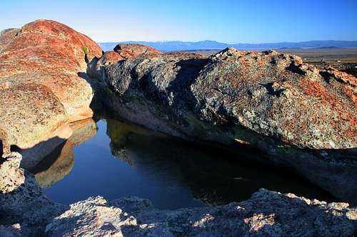 Summit tank on the Mosaic Wall
When traveling through Tres Piedras, it probably does not dawn on people that the Crags are open to the public. For the most part, this is the case as the rocks fall under the jurisdiction of Carson National Forest. However, the southwest corner of the formation does fall on private property. Although the landowner is not thrilled about climbing taking place on his property, he has not forbidden it. He has requested that a waiver be signed if one intends to climb on the portion of TP that lies on his land. In addition, to jstudebaker he states:
"Jan: Yes I still own the property, and yes I'd still like to have waivers on hand - even or perhaps especially from your organization. Only once in awhile do I have problems with climbers, mostly not picking up after themselves. My biggest gripe is that despite repeated requests, the climbers don't remove protection from the climbing routes, which is both lazy and unattractive. Your organization could do me a big favor by doing a group climb and removing the crap that others have left on the various routes so that it is both a pristine part of the landscape, and so that each climber must figure out his own route without relying on the handiwork of others. Gus Foster"
- Quote taken from Los Alamos Mountaineers website.
Regardless, little of the formation is on the property, and it is primarily for the South Rock and access to other climbing areas that it is import. It should also be noted that there are several old, historic cabins on the private property as well. Please refrain from entering the structures. It is important to be respectful of the property owner’s rights. He has graciously allowed access onto his land.
Carson National Forest
208 Cruz Alta Road
Taos, NM 87571
(575) 758-6200
Tres Piedras Ranger District
P.O. Box 38
Tres Piedras, NM 87577
(575) 758-8678
Carson National Forest's Tres Piedras Ranger Station lies less than 0.5 miles from the crags, along Highway 64. It is a great source of information.
Getting There
 Sangre de Cristo Mountains from the Tres Piedras Crags
Directions from Taos:
From Taos, head west 30 miles on Highway 64, crossing the Rio Grande Gorge Bridge and passing the Greater World Earthship Community. At the intersection with Highway 285, continue west on Highway 64 for 0.75 miles. At the large water tower, turn right and follow the dirt road for 0.5 miles to the trailhead.
Directions from Santa Fe:
From Santa Fe, drive north 80 miles on Highway 285. At the intersection with Highway 285, turn west onto Highway 64 and continue for 0.75 miles. At the large water tower, turn right and follow the dirt road for 0.5 miles to the trailhead.
Camping
The nearest established campground is the US Forest Service’s camping area at Hopewell Lake, 20 miles west on Highway 64. Dispersed camping is allowed on Forest Service administered lands. Campgrounds and dispersed camping is also available in the Rio Hondo Canyon near Taos.External Links
- Los Alamos Mountaineers Beta WorkupThis page has a couple of rudimentary maps and lists and descriptions of many of the routes, organized by which rock they are on. The second map of the entire crag complex is fairly accurate. The first one is worthless. This page is in PDF format so it may take a little while to load.
- Los Alamos Mountaineers
- LAM page for Tres Piedras
- Carson National Forest