Planning
We are good friends with an American diplomat in Stockholm and his family. They invited our daughter to spend a month with them in Stockholm. She is a little young to fly by herself, so I flew one way with her. She came back by herself, but I decided to have an adventure while there.
The goal: Climbing Kebnekaise, the tallest mountain in Sweden and one north of the Arctic Circle.
The local transportation is kind of difficult to arrange stateside. I looked into taking either a train or a jet from Stockholm. The train takes something like 25 hours and is about the same price as flying SAS, so one would need to have a lot of leisure time to go that way. (Even cheaper if you fly Norwegian Air, but they don't fly on Mondays.) I have limited vacation days, so it was not an option. Flying back at the end of the expedition, my ears failed to pop on the landing in Stockholm. Very uncomfortable. Next day, flying back to Philadelphia, the same thing happened. Didn't clear until I saw an ear, nose and throat specialist two weeks later. He had to pierce my eardrums and suction out the goop. Maybe I should have taken the train?
Then there is the issue of bus versus taxi. The taxi is much more expensive and must be reserved in advance. However, the bus schedule is set to match that of the train. There is only one SAS flight p from Stockholm to Kiruna each day. There is no way to take it, take the bus to Nikkaluotka, and still walk up to the Kebnekaise fjällstation before their reception desk closes.
Yes, that is right. They don't say it on their website or any of their email, but if you do not reach there by 9:00 PM, not only do you miss out on dinner, you also miss out on your room, your hot shower, et cetera. Do not be late! Do not take the bus! Either that, or you have to spend a night in Nikkaluotka.
The SAS flight lands at 1:15 PM. By the time you pick up your luggage, load it in the taxi, drive to Nikkaluotka, and arrange your gear, you will be lucky to hit the trail by 3:30 PM. It took us five hours to walk up the Kebnekaise fjällstation, including the boat ride across Láddjujávri. So we got there at 8:30, not much time to spare. Plus there was a line at reception desk. I think I waited there 20 minutes, so we got into the dining room barely before the close.
I had prepaid for full board. Dinner was 310 Swedish crowns per night (extra for soda, wine and beer). About $40 US. Didn't want to miss that after paying for it.
I also paid for linens. This includes sheets and towels. They did not give them to me and I did not know that I had to ask for them. By the time I figured things out, they were closed. So remember to ask for the sheets and towels.
There is also only one flight back from Kiruna to Stockholm per day. It leaves at 1:45 PM. You can't have breakfast in the dining room at the mountain station, hike down, and take a taxi in time to make the flight. You must either leave before breakfast or take the helicopter. The helicopter flight is very fast and reasonably priced. They can add it to your bill at the fjällstation. However, be sure they give you a ticket. The staff there charged me for it, but did not give me a ticket. The helicopter staff only check for tickets at landing, so that was a little awkward.
Also, there are no taxi's waiting at Nikkaluotka. You must arrange in advance or you will miss your flight. I had to beg a ride with other tourists in their taxi, or I would have been screwed.
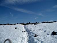
Walking up from Nikkaluotka
We hit the trail about 3:30. I had the 14-year old son of the diplomat with me. It was his first backpacking experience. We were carrying full packs for 5 nights at the Kebnekaise fjällstation. Although we were not carrying tents, food, water filtration equipment, or cooking gear, somehow it still managed to be quite heavy. I had gone through his gear, discarding much that I thought superfluous, but I did not check his bathroom kit. He had a lot of hair gel, shampoo, and other items. He suffered. Luckily, I had Ibuprofen with me when his hips started to hurt. The views are great on the way up. We reached the near end of Láddjujávri about 4:35. This is too late to grab a reindeer burger at Ladtjoluspkåtan by about 30 minutes and too early to catch a good trip across the lake. The next sailing was scheduled for 5:45. I was sure we could walk the 6 kilometers in less time than waiting for the boat, but since his pack was heavy and this was his first experience, we waited for the boat. Nice enough trip. I guess we came out about even on time.
![Boat schedule on Ladtjojåhka]()
Western Route
The guides on the eastern route will not take youth under age 16, so we had no choice but to take the longer and more arduous western route. It is somewhat safer than the eastern route, but there were still times when I feared for the safety of my young friend.
The walk took us 12.5 hours. Dining room hours were again a major concern. The room doesn't open for breakfast until 7:00 AM and it closes at 9:00 PM. If you pay for the packed lunches, they are very tasty, but you must pack them yourself at breakfast. (Breakfast is 90 Skr and packed lunches are another 80 Skr.) So it is hard to hit the trail much before 8:15 AM. But then you have precisely 12.75 hours before you miss out on your prepaid $40 dinner. So we had precious little time to spare.
The route is easy to follow for the most part. We were prepared for difficult water crossings, but they were not bad. We were able to cross without changing into water shoes.
For the first two hours or so, one goes up the Ladtjovaggi (Valley of the Ladtjojåhka) with no view of Kebnekaise. Then one starts climbing in earnest up the Kitteldalen. At about 1200 meters, there is a wide flat area where helicopters sometimes land, making the hike a bit easier. From there, one climbs a very steep snow field to the saddle between Tuolpagorni and Vierramvare. Then a rocky path to the summit of Vierramvare. There are hundreds of cairns at the summit. A whole city of them. The Swedish word for cairn is röse. Kind of fun and spooky at the same time. Sort of a Norse meets Angor Wat.
Then one has to dip down into the saddle between Vierramvare and Kebnekaise. A heartbreaking 180 meters or so to surrender.
Finally, up the side of Kebnekaise. The trail is steep and loose dirt for a couple hundred meters and then changes to scrambling over talus. Finally, about 1900 meters, we started to climb on a snow field.
At about that elevation, there are two shelters and an outhouse. The shit is piled up almost to the brim. Bring your own toilet paper. The Swedes need to develop a system like what US Park Service has at the high camp on Mount Rainier. The shelters are filthy and in poor repair as well. Snow in one.
The snow field was easy climbing. No need for crampons, but since I had carried them that far, I put them on just for the hell of it. Brand new, so I had to try them out.
The peak itself sort of reminds me of I.M. Pei's entrance to the Louvre. A funny pyramid of snow perched atop the mountain. Something about the wind patterns sculpts it. Easy climb to the top, but I was tense, imagining having to report to his parents if my young friend were to slip. There was basically death in every direction if one slipped. He was sure footed though and there was no problem.
On the trip back, we briefly lost the trail back down to the saddle (Kaffedalen) between Kebnekaise and Vierramvare. We somehow strayed too far east. We searched for it and found it. We had been thinking of just heading down to Kaffedalen from where we were. I was very glad later that we had not done this when I looked back up from Kaffedalen and saw the cliffs that we had been approaching.
Kaffedalen itself was covered in very wet snow. At one point, I was concerned that we might fall into I know not what. We backtracked and followed other steps on what seemed like firmer snow. As we started back up Vierramvare, my young friend quit on me for a while. Complained of a severe stomachache. I never heard of exertion causing a stomachache, but he had already climbed about 5500 feet. He had about 300 feet to do and was just about used up. I let him rest for a while, had him eat and drink some, gave him a pep talk, and he was back on the trail. Once we were back up on the ghostly city of cairns atop Vierramvare, he was good for the rest of the trip. We wanted to glissade down the snow field we had previously climbed. We saw others doing it. But he didn't have an ice axe, and there were large boulders at the bottom, so I didn't let him risk it. Silly excess of caution probably. Later though, I did hear that someone had died glissading down that snow field during the prior season.
Sidetrip to Tarfala
We decided to have an easy day after the big hike and just walk in the direction of Tarfala. The weather was cloudy and did not look favorable for another summit attempt. Unfortunately, the map that I bought only showed "summer trails" and there are both "winter trails" and summer trails in the area. The winter trails are laid out for snowmobiles and skiers to use. The snowmobiles cannot use the narrow bridges over the river -- nor do they need them once everything is frozen over. I could see that I was on a marked trail and since my map only showed one marked trail, I thought it was the one I wanted. But nope. It was a winter trail. When we came to the first river crossing, I took off my boots and put on my new Vibram FiveFingers® footwear that I had bought specifically for the purpose. I highly recommend them. They worked great. But my friend thought he could cross in his boots. I said no, please don't. It will go over the top and make you miserable all day. Too late. So he went back to the lodge and I futzed around for an hour or so until I figured out that there were two sets of trails and found my way back to the correct set. The trail to Tarfala is easy and beautiful. I never saw such an array of tall waterfalls, one right after another. And the Smadjejåhka is a brute of a river, ripping along under and between snow fields. I had wanted to cross higher up and try glissading on the bottom of the Storglaciären, but the water was too scary. I ended up turning back before reaching Tarfala. I wanted to get back to the fjällstation to see about climbing the eastern route the next day.
When I got back, the guide service was open with a favorable weather forecast for the next day, so I signed up. I went back to our cabin to tell my young friend that he would have another day on his own. In the mean time, another family had moved into out bunkroom. A couple with a teenage daughter and a dog. The father had been talking with my friend and seemed to like him. He and his family were planning the Tarfala hike for the next day that I had just been on. I was bold enough to ask him if he would mind taking my friend with him. He was more than agreeable, and it suited my friend, so the arrangements were final. I would climb Kebnekaise again, and my friend would hike with this very charming Swedish family.
Eastern Route
![Polarjud on the summit]()
![Henrik]()
![Our guide Petter]()
Although not required, the professional guides from the Kebnekaise fjällstation are a very helpful and pleasant group. We had Petter and Henrik. The vertical climb for the day would be about 4670 feet. We started about 8:00 AM. We packed two lunches plus snacks. The guides set a pretty hard pace. Anyone who didn't keep up on the way to the glacier was to be sent back to the fjällstation, but no one dropped out. We tourists numbered 7 women and 6 men. I was surprised that the women outnumbered us. I was close to being the oldest at age 52, but not quite. There was a slightly older couple from eastern Germany. We roped up for the crossing of the Björlings Glaciär. Bit of over caution. We saw no crevasses. Then we climbed up the cliff. Class 3 in places, but there so many fixed cables and steel rungs, that there is very little challenge left. I was glad I was wearing a helmet though when I pushed myself up too strongly in one spot and banged my head on an overhanging ledge. Once we got past the climb, it was an easy scramble across talus and then snow back up to the base of the final summit apex. Henrik had gone ahead and placed a snow anchor at the top and a rope tether to the top, so it was a lot safer than two days before with my young friend. Still the exhilaration was tremendous. The descent was easy and fun. We glissaded down long sections of the Kebnetjåkkaglaciären. The whole day took about 10 hours and 30 minutes. A much easier trip than the western route.
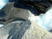
Silverfallet and the Giants' Cauldrons
![Devils Cauldrons]()
![Five finger shoes]()
On our final full day in the area, we explored two less awesome but beautiful attractions. Petter recommended the Silverfallet (Silver Waterfall) of the Siellavagge (Valley of the Siella River) and the Giants’ Cauldrons of the Ladtjovagge (Valley of the Ladtjojåhka or Ladtjo River). The Giants’ Cauldrons were particularly interesting. They are a little hard to find, but are pretty much due south of a small hill called the Lillberget. Petter had told us that there was one spot where it was possible to jump across the whole river. This seemed too incredible to believe as we walked down along the river. In most places, it seemed like certain death to try to cross. Finally, we found the spot. The river really does narrow to about a foot across. There is a narrow space between two rocks that must be awfully deep to allow so much water to pass in such a narrow space. The jump is still a bit tricky. You have to jump downhill onto a wet slippery spot, but it was great fun.
Helicopter ride out
A pleasant flight out in the morning. Very reasonably priced. 700 skr. per person. Be sure to pre-arrange a taxi for the trip into Kiruna. 1250 skr. per car. Otherwise, it is tough to catch the mid-day SAS flight to Stockholm. 2750 skr. per person.
Helicopter reservations
Taxi reservations
Comments
No comments posted yet.