
|
|
Route |
|---|---|
|
|
40.75320°N / 110.3592°W |
|
|
LONG hike/scramble |
|
|
A few days |
|
|
Up to Class 3+, but most of th e ridge is Class 2+ |
|
|
Approach
From the intersection of Highway 121 and Highway 40 in the town of Roosevelt in the Uinta Basin, drive west on 200 North (Highway 121). Stay on Highway 121 as it quickly bends to the north. Most junctions are marked with signs, but they are very hard to read in the dark. At mile 9.9, just after the actual mile marker 10 at a stop sign, at the hamlet of Neola go straight towards Uintah Canyon. At mile 16.7 continue straight. At mile 18, turn right to Uintah Canyon. At mile 21.9 turn right. At mile 22.2 turn left just after the bridge. Park at the trailhead at mile 25.6.Click for full size:

Route Description
Breifly put: From the trailhead (7800 feet elevation), follow the trail north along the Uinta River. After about 3 miles, you will reach a junction. You will turn left here, crossing Sheep Bridge and onto the Chain Lakes Trail. Follow the trail, steep in places to the Chain Lakes Basin. Lower Chain Lake is about 7.6 miles from the trailhead and at 10,580 feet elevation. 4th Chain Lake is two miles beyond and at 10,900 feet elevation. Any of these lakes make a fine campsite.From 4th Chain Lake, take the trail over Roberts Pass to the Lake Atwood Basin, and then over Trailrider Pass to Painter Basin. You could follow the trail all the way to Anderson Pass, but the shortest way is to climb the SE face of Kings directly. There is much boulder-hopping, but no major problems. From Kings Peak, continue south along the ridge to South Kings Peak.
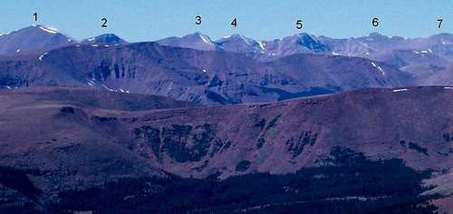
From South Kings, you continue following the main ridge south to Mount Emmons, passing over Peak 13,306; Peak 13,387 (“Painter Peak”); Peak 13,247 (“Trail Rider Peak”); Peak 13,287 (“Roberts Peak”), and Peak 13,068 (“North Emmons”). It is a long traverse and you must do it in good weather. Most of the ridge is class 2+, but there are a few short class 3 and class 3+ sections.
There are several possibilities for descending Mount Emmons, but his is probably the easiest. Descend the east slopes of Mount Emmons to a minor spur south of Oke Doke Lake. Continue on the ridge until the slopes aren’t very steep to the north. From here, you can drop north just to the east of two ponds. From there you can more-or-less follow the creek down to the area around 4th Chain Lake. All that is left is reversing the ascent route to 4th Chain Lakes and back to the trailhead.

Time Needed For Climb
Most climbers will need 4-5 days to complete the route.
Essential Gear
This ridge is very long, and completely above timberline. The weather is the number one concern. Thunderstorms and even summer snowstorms are very common. Bring a good pair of boots, and a pair that won't wear out after many miles of off-trail hiking/climbing. Since this is a multi-day trip, bring full camping gear.Proper gear?