
-
 16845 Hits
-
 89.39% Score
-
 29 Votes
|
|
Area/Range |
|---|---|
|
|
29.4626°S / 29.26630°E |
|
|
Hiking, Mountaineering, Scrambling |
|
|
Spring, Summer, Fall, Winter |
|
|
11424 ft / 3482 m |
|
|
Overview

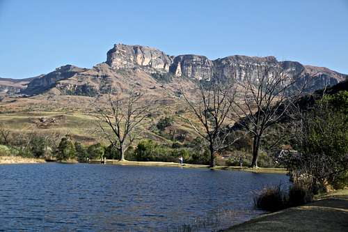
The Amphitheatre
The precise origin of the name is unknown but it dates from the early 19th century. In the Zulu language it is called uKhahlamba - the Barrier of Spears.
It is believed that Drakensberg provided an inspiration for the setting of The Lord of the Rings, written by South African-born J.R.R. Tolkien. (although the story was filmed in New Zealand). And the mountain region is mentioned in the 2012 film - towards the end of this action film the Dragensberg became the highest mountain range in the world since the entire area lifted up, and the rest of the world got flooded.
It is odd that the southern end of Africa’s Great Rift Valley, the 9,700 km (6,000 mile) scar that is slowly tearing the continent in two - inch by inch, millenium by millenium - should actually be a mountain range. But the final thrust of the geological fault is South Africa’s formidable Drakensberg, a 200 km (124 mile) arc of jagged mountain peaks that run roughly north - south through KwaZulu-Natal, forming the border with the mountain kingdom of Lesotho.
Soaring basaltic buttresses, incisive dramatic cutbacks and golden sandstone ramparts all contribute to a spectacular environment. It has been designated the World Heritage List of Unesco in 2000. The rock art of the Drakensberg is the largest and most concentrated group of rock paintings in Africa south of the Sahara and is outstanding both in quality and diversity of subject.
Geography
The Drakensberg Mountains are the massive outer rim of the escarpment of the great interior plateau, which is a major and climatically important feature of South Africa’s topography. It forms a crescent shaped area 200 km long, perched on the eastern border of Lesotho and stretching from the Sentinel in the Royal Natal National Park to Bushman’s Nek in the south. The escarpment itself and the plateau beyond are generally known as High Berg, perhaps the most famous for the 4 km wide sheer basalt wall of the Amphitheatre in the Royal Natal National Park. The highest point is the peak called Thaba Ntlenyama, lying inside Lesotho and at 3482 meters the highest point in Africa south of Kilimanjaro. Below the High Berg is an area of numerous, lower, grass-covered mountains and smaller hills, known as Little Berg, with its steep sided spurs and valleys.

Drakensberg Location
Drakengsberg comprises a northern and significantly larger southern section. The northern section is populated more densely, and the southern section (further away from Johannesburg) offers more solitude, is more lush and green, and even the possibility of spotting a leopard. The mountainous area between these two sections, knowns as the Mnweni area, is tribal land. The Drakensberg is one of the best watered, least drought-prone areas of southern Africa, and has significance for providing water supplies for surrounding communities.
The Drakensberg (or the Berg, as it’s often called) is divided in several sections. There is no single road linking all the main areas of interest so you’re better off selecting one (or a few) places rather than spending most of your time behind a wheel in search of sights.
The Northern Drakensberg runs from the Golden Gate Highlands National Park to the Roayl Natal National Park. Harrismith and Bergville are sizeable towns on this area where you can get major services, e.g banks, groceries, petrol (gas). It is located about 300 km from Johannesburg, and would take about 3 to 3.5 hrs by road to travel there. It is one of the most visited parts of the range, with Royal Natal National Park and the Amphitheatre being known for the most photographed mountain peaks.
The Central Drakensberg spans across a vast area and has several major regions: Cathedral Peak - is about 4 hrs from Johannesburg, 2.5 hrs from Durban by road. This valley is accessed via Winterton or Bergville. It has many hiking trails, and is named after scenic Cathedral Peak.
The Champagne Valley is also about 4 hrs from Johannesburg, and 2.5 hrs from Durban. This valley is a tourist mecca offering a lot of recreational opportunities.
Injisuthi is about 4.5 hrs from Johannesburg and 2.5 hrs from Durban by road. This area provides more solitude.
Giant’s Castle is about 5 hrs drive from Johannesburg and 2 hrs from Durban. this area is well known for Bushmen paintings.
Kamberg is about 5.5 hrs from Johannesburg, and 2.5 hrs from Durban - is home of the best Rock art in Drakensberg.
The Southern Drakensberg is located about 300 km away from Durban and is famed for Sani Pass. This area is less developed that the others, but is no less spectacular.
History of the Park
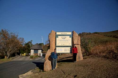
Entry to the Royal Natal National Park
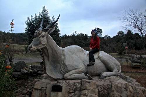
Eland at Cathedral Peak area visitor center.
In October 1903 the Natal Colony government took the first step towards the establishment with a Government Notice which stated its intention to create a game reserve on the Crown land in the vinicity of Giant’s Castle. Next came the establishment of the Natal National Park in 1916, the prefix Royal being added after a visit by the British Royal family in 1947. Gradually more areas were protected by the purchase of farmland and by the late 1960s the park was more or less what it is today.
It comprises 242,813 hectares (almost 2500 km2) and is the largest mountain wilderness area in Africa. The official title “the uKhahlamba-Dragensberg Park” was introduced in 2000.
Ezemvelo KwaZulu-Natal Wildlife = EZKZNW) is the conservation management agency in the province of KwaZulu-Natal and is responsible for the Park. K
Bushmen Paintings
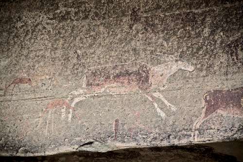
Bushmen rock art - this one is depicting eland

Guide is required when visiting any rock art painting.
The Bushmen (or San people) were classical hunter-gatherers (do you remember the little guy with a coke bottle from the film Gods Must Be Crazy?). The practice of rock painting started at least 2000 years ago and finished when the last of them disappeared in the 19th century. The bushmen were pushed away by Zulus and whites into Kalahari area.
Bushman art was first noted by white settlers about 350 years ago, but for the most part were seen as crude scribbling of a savage society. But over time their artistic sophistication and clearly deep meaning were appreciated.
The rock paintings of Game Pass Shelter at Kamberg were among the first to be recorded from the Drakensberg when white settlers arrived in the 1850s, and they were described in Scientific American as far as 1915.
In the 1980s, archeologist David Lewis-Williams cracked the meaning of some of the rock paintings. The common image shows an eland (an animal sacred to the Bushmen), sometimes in its death throes. Its tail is held by a therianthrope - a mythological creature with a human body and often a bizzare looking antelope-like head. Lewis-Williams realized the therianthrope was the Bushman shaman who painted the image, in the act of drawing spiritual power from the dying eland.
Some paintings are monochromatic but others use two colors or more. The colors tend to be limited to red, brown, yellow, black and white because of the available materials. Paintings in black and white are mole likely to have deteriorated or disappeared, so most of those remaining are of the yellow-red-brown spectrum. Bones, sticks, or fingers were used to apply the paints.
There are several threats to the rock art of Drakensberg. The principal ones are natural weathering of the paint (and of the rock - sandstone) and sadly, vandalism. Fires lit by people camping in the overhanging shelters created smoke damage and some visitors have even wet paintings to improve the colors.
Access to Bushmen painting sites is permitted only if accompanied by registered guide (and extra fee).
Fires
Winter Trail scenery - controlled burning is very common.

Common Tree Fern
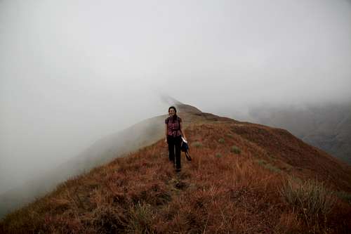
When walking in the Drakensberg you will frequently come across areas of burnt grassland. It can look awful. Most of these fires were set up as controlled burns, some are from lighting and arson.
The use of fire in grassland management is long-established and, when used appropriately, of good benefit. It removes dead organic material in the winter. The main aim in Drakensberg is to maintain grass cover for soil and water conservation. Firebreak creation is important strategy for limiting the spread of natural or deliberate fires. Controlled burns are often carried on two or three year cyclical basis. It is important to check and be aware of controlled burns, you don’t want to walk into it. The information should be available at the visitor centers. These controlled burns rarely kill trees, grass growth is enhanced, and some plants, for example Protea caffra, require the smoke to stimulate dormant seeds. Bigger animals escape the fire,and most of the smaller ones survive in burrows.
Getting Clear of a Fire: If the fire comes towards you and escape is not possible, light the grass around you and follow the line of flames downwind so that you are in a grass free zone. I was watching some of these controlled burns taking place, and it was amazing how quickly they burnt and stopped.
Tree fern are capable of producing renewed frond cover within weeks of fire, their living core being insulated by their fibrous exterior. Tree ferns frequently survive wildfire and attain ages of greater than 300 years.
Health Matters
Malaria - there is no risk for malaria in Drakensberg. There is also no need for special vaccines like Yellow Fever. You can always check information available on CDC website - Traveler's Health.
Gastrointestinal Infections: There is always a risk of gut infection when traveling abroad. Simple precautions such as avoiding fruit that cannot be peeled and drinking bottled water will minimize the risks. I have seen south african hikes drinking directly from the stream, however I would not recommend this - the consequences could be serious. Consider carrying water purification tablets.
Dealing with snake bites: I have visited during south african winter, and have not seen any snakes. Snakes tend to be most active during the summer (December, January, and February). There are at least 3 poisonous snakes living in the Berg: Puff Adder (Bitis arietans), Berg Adder (Bitis atropos), and Rinkhals (Hemachatus haemachatus). Most snakes escape when they hear you coming. Wearing appropriate footwear may provide some defense. Some bites can by dry - no venom injected, so try not to panic if bitten. Immobilize the limb using a splint or a sling. Get help - mobile phones may not have a signal in parts of the Berg, send a "runner". Try to keep victim calm. Wipe excess venom, but do not cut, squeeze, or suck the bite.
Altitude: the heights here are not extreme, but especially if coming from sea level and moving fast, this could be a potential issues.
Dehydration: again same as anywhere else, bring water with you. You can buy bottled beverages, including electrolyte liquids at visitor centers.
Wildlife
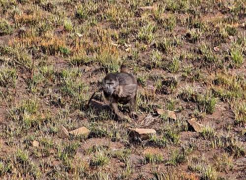
Baboon lifting up rocks and searching for insects underneath it.
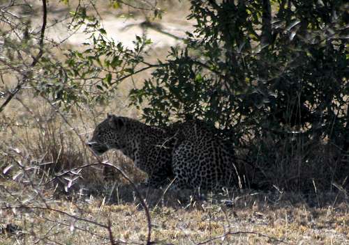
Leopard - still living in southern Drakensberg.
Antelope: Eland, Mountain Reedbuck, Grey Rhebok, Common Reedbuck, Oribi, Blesbok, and Common Duiker are amongst the most common ones in the Berg. Eland is the largest African antelope. Drakensberg is the only place in South Africa when you can spot this wonderful creatures. Males may weigh up to 900 kg. They live in herds, although some are solitary.
Rock Dassie (Rock Hyrax) - sociable animals, look like rodents but are not. They are rock dwellers. Their main predators are eagles.
Black-backed Jackal - dog like carnivore, hard to be seen, mostly nocturnal animals. Their diet ranges from baby antelope, birds and rodents down to berries and fruit. Unfortunately they also kill sheep and goats.
Leopard - this magnificent animal is hard to spot, again mostly nocturnal. It is the only large predator living in the Park (mostly southern parts). There is no risk to walkers.
Getting There

The Sentinel Road
The one frustration is that there are no connecting roads along the mountain peaks so the whole regions ends up being divided into clearly defined districts. A main road, the N3, runs parallel to the range near its base, and a series of side roads lead to small towns including Himeville, Underberg, Balgowan, Nottingham Road, Rosetta, Mooi River, Estcourt, Winterton, and Bergville. From these, mountain roads climb into different areas of the park. The reach the next, you either have to come back down or go on foot.
By Car: The N3 highway (a toll road) is the major road artery through KwaZulu-Natal and connects with Durban to the south and Johannesburg to the north. One of the regional roads leading off the N3 will get you to where you need to be. There are many signs along this road for different sections of the Drakensberg.
By Plane: There are no major airports in the region. The nearest international airport is in Durban. Pietermaritzburg has a smaller regional airport with daily domestic flights. Johannesburg has a large modern international airport.
By Bus: Baz Bus runs a regular service between Durban and Johannesburg/Pretoria with stops in Pietermaritzburg and at he Amphitheater in the Roayal Natal National Park.
Underberg/NUD Express: runs door to door shuttle service between the Sani Pass lodges, Underberg, Pietermaritzburg, Howick, Kokstad, and Durban.
The best way to get around is by hired car. Be cautious of potholes on the road. We blew two tires during our trip.
Red Tape
Fee: It is a national park, so expect to pay an entry fee. During our visit the charge was 30 Rand per person per day (about 3$ per person per day). We also gave a small fee (about 2 Rand) at parking spaces, and another extra fee (this may vary from place to place, we were charged 30 Rand per person) for visiting rock art. Guides take only cash, and ATM machines may be available only in close by cities (they are none inside the parks).Filling papers: You will have to fill paperwork when entering the park - like number of people, vehicle registration number etc at the entry gate, then more paperwork at the start of some hiking trails, e.g. we had to fill paperwork when hiking Thukela Gorge: again our numbers, phone number, color of our backpacks etc. This was not required for Cathedral Peak (at least we did not see anyone at the TH).
Guides: you have to have a guide when viewing rock art. We were also recommended to hire a guide for Cathedral Peak, but decided to go on our own. The trail was easy to follow.
Opening Hours: The different sections of the Park have entry gates and you cannot get in before they open. Typically 8 to 5. You can stay inside the park (hotels, lodges, camps) if you wish to have an early start for your adventures.
Safety: within the park I felt safe, our hotel (we stayed outside the Park) was secured and guarded as common in South Africa. We had no incident of breaking into the car or any other major problems.
External Links
- Drakensberg on UNESCO web site
- Wiki page for Dragensberg
- History of the Park
- Ancient Bushmen Rock Art
- San Rock Art at Drakensberg: Barrier of Spears on pbs
- Ezemvelo Kwala-Zulu Natal website
- Drakensberg on-line: nice comprehensive website
- Drakensberg Hikes
- Drakensberg Hiking Trails on Discover our Drakensberg
- Drakensberg Weather Forecast
Below will be described some of the most popular hikes in different parts of the uKhlahlamba-Drakensberg range.
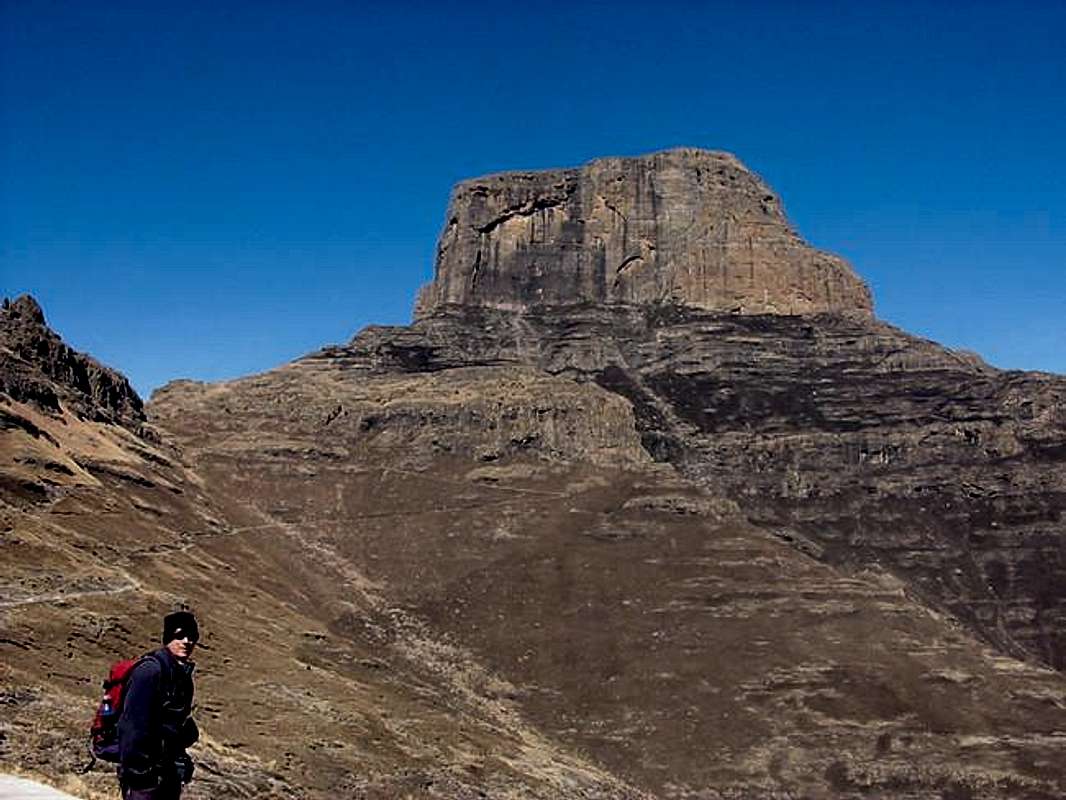
The Royal Natal National Park is isolated from the rest of the uKhahlamba-Drakensberg Park by the farming area of Mnweni, was so designated in 1916. It attained the additional title of “Royal” after a visit by the British Royal Family in 1947. The principal and famous feature here is the Amphitheatre, a stunning and sheer basalt wall about 5 km in length and over 1000 meters in height, extending from Sentinel (3165 meters) to the Eastern Buttress (3045 meters). Thukela river starts high up in the Amphitheatre and tumbles down in a series of five leaps, together giving a height of 948 meters. Most give it the accolade of the 2nd highest waterfall in the world after the world champion, the Angel Falls in Venezuela. Unfortunately, during our visit, dry winter season, the waterfall was mostly dry and only a little bit of water trickled down.
Dam - near the visitor center, popular with fishing.
There is a visitor center in this section of the Drakensberg, a fee station (cost is currently 30 Rand per person per day) at the entry to the park, and well marked trails. You can stay both insie the park, or outside Hotel Mount-aux-Sources is located only a couple of km from the entry gate. Great place for lunch or dinner is Tower of Pizza (surprisingly good pizza and a very nice setting).
Plouwman’s Kop - round trip rom Mahai camp site via Plowman’s Kop.
Distance: 10.5 km Duration: 3-4 hrs
A whole day can be spent on this hike if you wish to absorb natural wonders. This hike takes you to the pools above Gudu Falls on Plowman’s Kop. Starts with a steep ascent and descent up the kop (meaning ‘head’, or hill).
The Crack - a nice outing, which involves easy scrambling and a chain ladder, and leads to topographic feature and geological oddity.
Distance: 10 km to the top of the of the Crack and return
Duration: 5 hrs
Also starts at Mahai camp site, fun excursion in the Little Berg. The Crack is about 100 meters high.
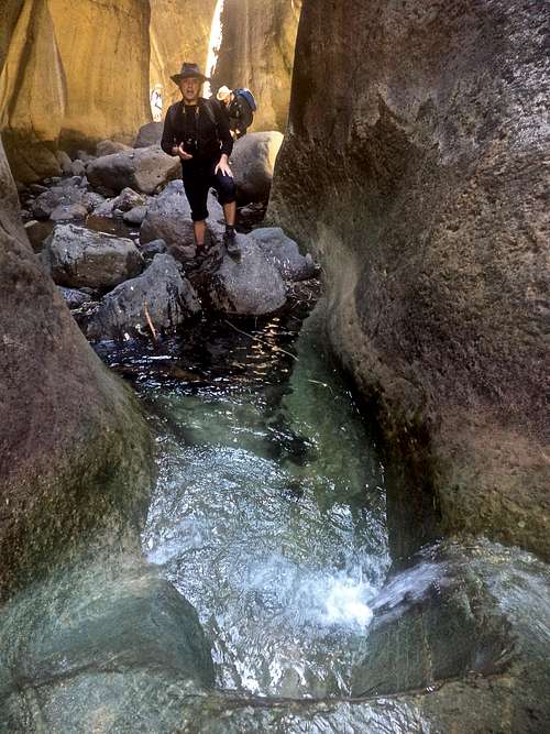
Fun exploring inside the Thukela River Gorge.
Distance: 9.5 km
Duration: 4 hrs
The start is Mahai camp site. The falls at the end is literally the cherry on top; a waterfall of about 50 m falling into a big pond popular for swimming and trout fishing.
Thukela (=Tugela) Gorge (=or just the Gorge). The hike leads to the second highest falls in the world - Thukela (Tugela) falls, and a nice gorge.
Distance: 13 km to the picnic spot and back (more if continuing above chain ladders)
Duration: 5 hrs (more if going towards the base of the falls)
The start is at Tendele Car Park, and this is one of the most popular hikes in Park (expect to see people on this one). If offers excellent views of the Amphitheatre and the situation around the gorge is exciting. We had to pay a small fee for parking and fill some extra paper work at the car park. The path is easy to follow, towards the end you will come to a scenic gorge and you will have to wade through water. It is fun to explore inside the gorge, and if you want to continue towards the base of the falls, it is easier to avoid the gorge and climb the chain ladder, and afterwards a small nearly vertical gully equipped with some large metal pins you can step on during climbing (almost like a little via ferrata). It did not feel to exposed. You can continue upstream towards the falls, there are many nice pools, trail is almost non-existent. During our visit, the falls very nearly dried up, but supposedly during the wet season it is an impressive sight.
Policeman’s Helmet - a nice walk to a prominent top which looks like its name. There is an easy scramble to finish.
Distance: 13 km
Time: 4.5 hrs
The hike starts at Tendele Car Park.

Camel's Hump is 1892 meter high hill
Distance: 10 km if starting at Ruggled Glen, 6 km if starting from Mont-aux-Sources hotel.
Duration: 4 hrs
This walk has two possible starts: at Rugged Glen campsite or the Hotel Mont-aux-Sources. Camel Hump is visible nicely from the road, so it is hard to get lost on this one. The view from its top is nice.
Sunday Falls - easy hike leading to a nice picnic spot with a stream and waterfall.
Distance: 7 km
Time: 2.5 hrs
You can start either at Visitor Centre or at Mahai Car park.
Surprise Ridge and Cannibal Cave - a moderately long but easy walk through a grassland leading to a historic site.
Distance: 19 km
Duration: 6 hrs
The start is the same as for Sunday Falls. The Zulu King Shaka despatched forces to conquer other tribes. Many people fled into Drakensberg and some hid in this cave, or better a large overhang. The name tells it own story and solution to their starvation. There is a small village called Cannibals right before you enter Roayl Natal National Park.
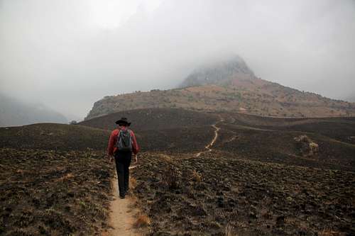
Sentinel
Distance: 10 km to the top of Thukela Falls, 16 km to to Mont-aux-Sources
Duration: 6 hrs
The start of this walk requires a drive to Sentinel car park. Count about 2 hrs on reaching this destination and pay attention to potholes on the road. The path is exposed in places, but plenty wide. There are 2 parallel ladders rising vertically about 20 meters, above is 2nd set of ladders. See SP site for Sentinel.
The Sugar Loaf - an easy walk to a nice summit. Antelope are often seen on this hike.
Distance: 7 km
Duration: 3.5 hrs
It starts at Cavern Berg resort. If you know the area you can descend from this walk to Cannibal Cave.
Cathedral Peak

Cathedral Peak
Mushroom Rock - a relatively short walk to a geological formation resembling mushroom.
Distance: 5 km
Duration: 3 hrs
The hike starts at the hotel. Follow the signs for Doreen Falls. At 1.2 km take right fork with a signpost. You can go through the hole in the mushroom easily and pose for a photo.
Rainbow Gorge - The walk basically follows Ndumeni River upstream, kicking into a narrow gorge where, at the right time of the day, water dripping down the sides throws up sparkling rainbows.
Distance: 15 km
Duration: 6 hrs
Leave the Hotel Reception heading uphill, there will be signpost directing you on the right trail. This walk offers a strenuous adventure through forest, over rock and into water. Rainbow gorge proper is narrow, there is a chockstone jammed between the high walls of the dark gorge. It looks low and small when first seen from a distance, but as you get closer, water dripping from above, it looks more impressive. Standing underneath defines the formal end of the journey but adventurous souls can explore further.
About halfway up the trail climbs up a grassy ridge, locally known as Swine Hill.
Distance: 7 km
Time: 3 hrs
Again, start is at Cathedral Peak hotel, initially the same as for Mushroom Rock and Doreen Falls. It is sing posted trail.
Organ Pipes Pass and Cleft Peak - a tough hike if you include Cleft Peak in the same day. The route is mostly on a good path, but with significant exposure in places at the top end of the route.
Distance: 18 km to Organ Pipes Pass (22 km to Cleft Peak)
Duration: 8 hrs to Organ Pipes Pass (10 hrs to Cleft Peak)
Again, as all hikes in this area, the start is at Cathedral Peak hotel and there are sign posts for Cleft Peak. Elevation gain is 1600 meters to Organ Pipes, and almost 1900 meters to the summit of Cleft Peak. See SP page for Cleft Peak for more information.
Scrambling on Cathedral Peak
Distance: 9 km
Duration: 4 hrs
The start is at Golf Club right below the Cathedral Peak hotel, again is it well signed. Baboon Rock is usually seen from the hotel, again during our cloudy/foggy visit we did not see this rock formation.
Cathedral Peak - the classic route of the area. There are sections of scrambling with some fixed aids, and it is exposed.
Distance: 19 km
Time: 9-10 hrs (could be done much faster if jogging on the way down)
Walk up from the hotel to the trout hatchery and follow the sign towards the river, cross, pass two mountain bike trails and follow the trail. Orange Peel Gap provides a nice rest. The hike is nice and very scenic. SP site for Cathedral Peak.
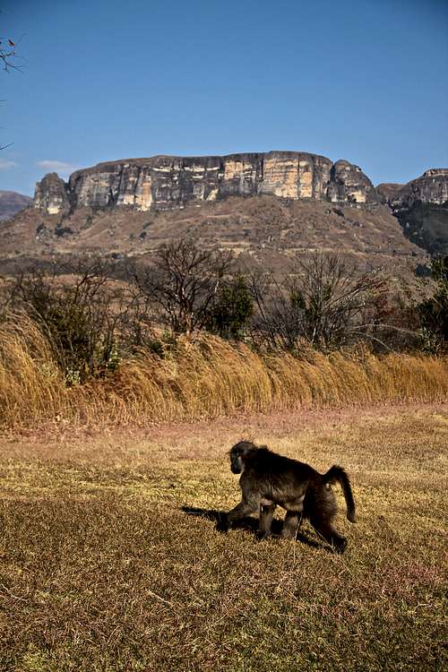
Baboons are so common throughout the park.
The Champagne Valley nestles below. There are excellent self-guided walks to suite all levels of fitness. Not to be missed is the river walk with many forests and waterfalls.
More information on this area is available here.
Injisuthi - some people call it "the hidden gem of the Drakensberg". The name is taken from Zulu meaning "well fed dog". One of the attractions of the park is Battle Cave, a series of Bushman paintings depicting a great battle between two tribes (this is a guided walk). There are several other walks around the park and to the summit. Elands are frequently encountered here.
Giant's Castle - Giant's Castle Nature Reserve is known for its magnificent San rock art, fabulous hiking and great climate. This reserve was named in honor of the peaks of the Drakensberg mountains, whose silhouette resembles that of a sleeping giant. Eland and the bearded vulture are two popular wildlife found here + baboons (those are all over Drakensberg), and there is a vulture restaurant open in winter for visitors to watch bearded vultures feeding. Vulture restaurants provide animal carcasses for the birds to feed on safe meat undisturbed, after their decline has been hastened by farmers lacing carcasses with poison to kill livestock predators such as hyenas and big cats.
More information about Giant's Castle is here.

Game Pass Shelter
Distance: 5 km
Duration: 1.5 hrs
Just across from the camp reception a signpost directs you to the Main Caves. As mentioned above, this is a guided walk and brings you to a large shelter with more than 500 san paintings and life-size models depicting the traditional san way of life.
Kamberg - this area is situated in a wide valley and is somewhat distant from the high Berg. The reason for its popularity is Game Pass Shelter, the renowned rock painting site, and the associated rock art Interpretative Center. Fishing is also popular here.
Game Pass Shelter - This is an easy hike, and you are required to have a guide. The Game Pass Shelter is commonly referred to as the Rosetta Stone of South African rock art, it was here that archeologists first uncovered a vital key to understanding the symbolism of the San Bushman rock art paintings.
Distance: 7 km
Time: 3 hrs
Leave the Interpretation Center, again you should book your guide beforehand. The walk is easy, you pass a seasonal waterfall and come to a large overhang.

Sani Pass
More information about Southern Drakensberg available here.
Hiking trails of Southern Drakensberg here.