August 2007, time for a ROAD TRIP !! I started Wednesday afternoon August 1st driving from home in Medford, Oregon, heading east. I took my usual route, Hwy 140 to Lakeview, Hwy 395 to Burns, Hwy 20 to Ontario, and then I-84 east… The only problem is that it takes me 8+ hours just to get out of Oregon. I was tired and stopped before I got to Burns and crawled into my mobile motel for the night that I call the Tacoma Hilton.
Early the next morning, I was on the road again because I needed to meet SP’er
Dean in Jefferson County that afternoon. We had a whole week of county highpointing planned and wanted to tag the Jefferson County highpoint that afternoon. Jefferson County is in Eastern Idaho and the highpoint is east of Idaho Falls. When I got cell reception a few miles west of Ontario, I called Dean to see if he was on the road yet from Kennewick, Washington. Surprisingly, he answered his phone and he was just pulling into Ontario also. Our timing couldn’t have been better even if we planned it. We met at Denny’s next to I-84 in Ontario and had breakfast.
![Diamond Peak]()
After breakfast we headed east on I-84 all the way across Idaho to Idaho Falls and then east on Highway 26. We didn’t have any problem finding the Kelly Canyon ski area where the county highpoint is located. It felt good to get out of the truck after driving 900+ miles and stretching my legs to tag this easy summit. It isn’t really a summit. It is a highpoint on a ridge. Some of these county highpoints aren’t real exciting and this was one of them.
After, Kelly Mountain, we returned to Idaho Falls for dinner and then we headed north to Clark County and
Scott Peak/Webber Peak. It was dark now and there was a torrential thunderstorm overhead. We slowed down, but kept going. By the time we got to our turn-off for the trailhead, the roads were awash in runoff. We have 4WD, so we kept going. It is about 10 miles of gravel/dirt roads to the trailhead for Scott Peak and the further we went the more water and mud bogs we plowed through. It was exciting watching the lightning and trying not to get stuck in these massive mud holes. As we made our way up the last mile to the trailhead the rain finally stopped and we were able to locate a flat parking spot to car camp for the night. We were both tired and we crawled into our truck bunks to try to get some rest.
![Diamond Peak]()
Early the next morning we got up to perfectly clear skies and a beautiful day for hiking. We had all day to hike Scott Peak and then get over to our main objective, Diamond Peak. We took our time, tagged Scott Peak, Webber Peak and the Clark County Highpoint before returning to the trailhead about 9 hours later. Thunderstorms were forming again and about the time we got back to the paved road, it was pouring rain on us again. We drove slowly for a couple of miles before the thunderstorm passed and then we continued a few more miles before turning off on another dirt road that goes to Diamond Peak.
The road to Diamond Peak passed through a couple of barbwire gates as it progressed across the valley towards the trailhead. We were supposed to meet SP’er
rfbolton and fellow Ultra Prominence Baggers Duane and Grant (all from western Washington) at the Diamond Peak Trailhead. Diamond Peak is one of the
57 Ultra (5,000 ft) Prominence Peaks> in the Contiguous 48 States. This was to be Bob and Duane’s 55th Ultra Prominence Peak.
Dean and I surmised that Bob, Duane, and Grant wouldn’t get to the trailhead for several hours yet, so we would just go there and get set up in the best spots. The road to the trailhead is somewhat circuitous and then when you get close you have to switch to 4WD and descend through a dry creek bed before ascending the last half mile to the trailhead. Just as we were driving down to the dry creek bed, there was Duane’s explorer ahead with Bob and Grant moving rocks off the road to keep from damaging the Explorer. We all gave a big wave and yell as we met. Another perfect timing for arriving at a trailhead. We couldn’t have planned it better.
![Diamond Peak]()
Shortly, we managed to get all our trucks up to the trailhead on the east side of Diamond Peak and we were all busy trying to level our traveling motels so as not to create any hardships for sleeping. There is plenty of room here, so we were able to spread out a little to keep from hearing each other snore. Grant didn’t have a vehicle to sleep in, so he pitched his two man tent down the trail a ways on a flat spot.
It was still only late afternoon, so we took our time socializing and telling tales about our adventures. We had a great group and we all took our turns looking at Diamond Peak and sizing up the hike for the next day. It wasn’t far to the summit, but it sure is steep!!!
We all had some kind of dinner and then one by one we turned in and tried to get some sleep. In the morning, Dean begged out of the hike claiming he was spent from the effort on Scott Peak the day before, and him being the senior citizen of the group we understood fully that he just didn’t want to hike with a bunch inexperienced amateurs like ourselves. After dispensing enough grief on Dean to make a grown man cry, we headed off towards Diamond Peak. Dean took the chastising well as he crawled back in his sleeping bag and went back to sleep. He needs his beauty sleep.
![Diamond Peak]()
The trail to Diamond Peak disappears shortly, but the terrain is very open and you can see where you need to be going. Bob took the lead since he and Duane had been here a year earlier. They had been stormed off the upper ridge. They knew the way and Grant and myself were just tagging along trying to keep up. It was another beautiful day with a few high clouds and we made good progress from the trailhead at 8,000 ft to a little saddle at about 9,400 ft. Up to now it was all good footing following cow trails. At 9,400 ft we had to start climbing a scree/talus steep slope up to a ridgeline at 10,200 ft. We all kind of split up and took slightly different parallel routes up this section trying not to kick rocks down on each other. That is a tough little climb and coming down it wasn’t any easier. On the way down most of us wound up on our butt at one time or another because of the loose footing.
Once at the ridge, the fun started for the climb. We first traversed to our right over to the east ridge and then up the ridge to about 10,700 ft before we encountered the beginning of the Class 3 climbing. From here to the summit there are several areas of Class 3 climbing interspersed with Class 2 stuff. It is probably only about 30% Class 3. The Class 3 rock is good and solid for the most part, but you have to look around carefully to find the easiest route. It looks like climber’s have tried many different paths around some of the obstacles, so if one doesn’t work for you, then try another. We didn’t necessarily follow in each other’s footsteps and usually 2 of us took one path and the other 2 took a different path. In the end it rally didn’t matter because we all came together again further up the hill.
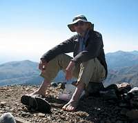
We took our time and still got to the summit early on a beautiful clear warm summer day. We stayed on the summit for at least an hour, ate lunch, took lots of pictures, and congratulated each other heartily. We could see to our north
Bell Mountain had a few thunder clouds forming, but over Diamond Peak it was perfectly clear.
When we were sufficiently pleased with our accomplishment, we reluctantly headed down the same way we came up. We took our time going down because we wanted to be safe. At the bottom of the Class 3 section we met 4 other hikers who were heading up. They seemed to be ill prepared and were more interested in looking at the mountain goats far off to the north. As we were bidding them good luck, we saw a bit of a cloud forming behind Diamond Peak. It looked like it may develop into a thunderstorm, so I took the lead and headed down at a good pace.
In about 30 minutes, just as we got to the bottom of the scree slope, we met Dean who had wandered up the hill after his beauty sleep and having a big breakfast. He was feeling better and his beauty sleep did him wonders. Then, it started raining and so we hurried a little faster now that we were on solid footing. Within a few minutes, lightning was striking high up on Diamond Peak and it started hailing on us. We tried to hurry faster, but there is only so fast this old guy can hurry. Hail was really coming down now and the wind was really blowing, so we found a bit a shelter in a clump of trees and put on our rain gear. We needed protection from this hail. A few of us put our rock helmets back on. Lightning was flashing overhead and the thunder was deafening. There was no place to hide, so we continued down towards the trailhead. In about another 10 minutes, the hail stopped, the rain stopped, and the lightning was moving further east.
We could finally relax and took our time going down the last half mile to our campsite. Grant’s tent had been flattened by the wind. A pole was broken and the tent fabric torn. We all changed out of our wet climbing clothes and made ready to break camp and move on to our next objective. The weather continued to clear and within an hour it was a beautiful clear blue sky again. While we were packing our stuff, one of the climber’s we had passed on their way up, came back to camp. He said he turned around when his hair was standing on end because of the electricity in the air. His companions had hunkered down in the rocks to wait out the storm.
The climb only took us about 7 hours, but it was exciting. This is a great climb with lots of diversity in a beautiful area. Now our group split up with Dean and I heading to
Mount Baird in Bonnevile County, and Bob, Duane, and Grant going north to Montana with their eyes focused on
Snowshoe Peak.


Comments
Post a Comment