
|
|
Route |
|---|---|
|
|
40.12226°N / 15.96556°E |
|
|
Trad Climbing |
|
|
Spring, Summer, Fall |
|
|
Most of a day |
|
|
5.9 (YDS) |
|
|
TD- |
|
|
11 |
|
|
VI |
|
|
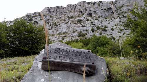
sGeneral Information
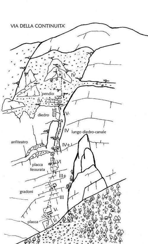
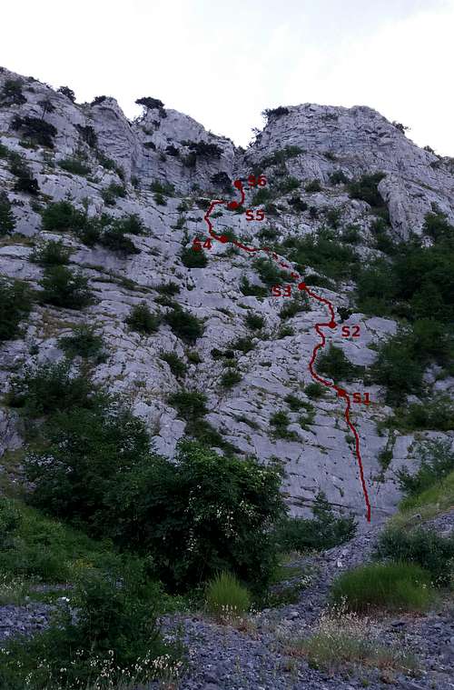
Via della Continuituà - route sketch*
The route was first climbed in trad stile by Rocco Caldarola and Luigi Ferranti who worked out a way up the compact limestone escarpment forming the base of the west face and, higher up, through a distinctive couloir. Brought to completion in several attempts between May 3rd and September 29th 2002, the route is partially equipped with pitons used during the first ascent. Only recently two stances (S1 and S2) have been fixed with steel bolts.
Approaching the west face
The name of the route (engl.: "Route of continuity") is referring to the persistence and tenacity of the two alpinists and not, as one might assume, to the actual course it takes. In fact, both difficulty and character of the single pitches are rather non-uniform.
By now a true classic, this route is still a demanding enterprise. Although the overall difficulty is not exceeding VI (UIAA), the sheer lenght, the rock quality - surprisingly good on some pitches (L1, L2 and L8), rather poor on others, the problematic retreat options and the potential risk of rockfall inside the couloir of the central part are not to be underestimated. And there is also the fact that from the official end of the route (S11) it is still a long and fairly exposed scramble on steep grassy slopes and often loose rocks up to the broad west ridge which eventually rises towards the summit.
What's more, the long descent on the south-facing slopes of the mountain is somewhat precarious, too. Though initially you may come upon a few small cairns, there is no easily discernable trail and it takes about 2 hours of walking on unstable terrain and through the dense undergrowth of the beech forest to get back to the dirt track and trailhead.
Best seasons for climbing this route are, for obvious reasons, spring (April, May) and autumn (late September, October). Given its particular exposure (west), however, it can also be tackled at midsummer. But be assured that the sizzling heat under the southern sun will take its toll. Bring a fair supply of liquids, suncream and, for the ridge, a hat.
All in all, "Via della Continuità", in its entirety, is a fantastic and highly rewarding experience in a severe and remote environment not often travelled. It offers stunning views, unexpected turns and secrets to be discovered with every meter that brings the climber closer to the summit of this solitary mountain.
*image source: Roccia&Resina
Getting There
On the state road SS653 take the exit for Latronico and follow indications for Calda, Contrada Serrone and, later, for Castelsaracceno. At the intersection Cogliandrino take the SP19 Moliternese and follow indications for Frusci and Castelsaracceno. Always keep on the main road. A few hundred meters before the locality Frusci you can park at the side of the road, beneath a solitary tree opposite to a dirt track that branches off in direction of the west face of Monte Alpi (coordinates: 40.114794, 15.954373).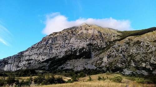
Monte Alpi - west face from the trailhead
Follow the dirt track for about 500m and cross the slopes at the feet of the mountain in direction of a distinctive scree ramp almost at the center of the escarpment. Cross the shrubland and try to keep direction. Where the slope gets steeper, climb the scree ramp until reaching the slick wall that forms the base of the mountain. The route starts on the right side of the final scree ramp, at the edge of the forest. Look for a conspicuous fissure and an old piton with a metal ring.
Roadside/Trailhead - Monte del Papa (Sirino range), background
Note: There are two more climbing routes by the same authors only a view meters to left of this route: "Via di Mezzo" - TD, VI (UIAA) and "Stellina dell'Alpi" - TD, VI- (UIAA). Slighly more difficult than "Via della Continuità", these routes are less protected with pitons. Both routes, however, eventually lead up to the same broad ledge, the "Amphitheater", from where it is possible to rappel down the respective route, or continue up the mountain with the 6th pitch of the "Via della Continuità". For a detailed view see also here.
Route Description
![Via della Continuitu00e0 - first pitches]()
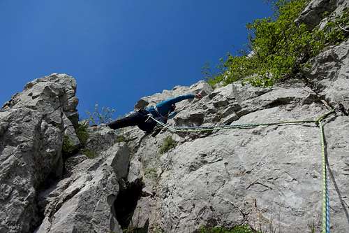
Via della Continuità - first pitches1st pitch - 20m, V- (UIAA) - Straight forward climb on steep and compact limestone slab with several vertical cracks and clefts that make for good hand and footholds. Follow the vertical fissure that runs almost the entire pitch and is protected with several pitons. A slighly arduous move takes you to stance S1 (two steel bolts), situated on a broad ledge.
Via della Continuità - first pitches
2nd pitch - 20m, V- (UIAA) - Quite similar to the 1st pitch regarding rock quality and difficulty. Here the still compact limestone forms larger step-like slabs. After a short traverse to the left a narrow and rather smooth ledge (to the right) leads to S2, situated bellow a young Bosnian Pine. Also this stance is fixed with two steel bolts and accessory cord which may have to be replaced.
3rd pitch - 35m, III, IV- (UIAA) - Climb straight from the stance and follow the small crack. Keep to the left of a small bosnian pine. The first meters on good rock and protected with a piton are the hardest part of this pitch (IV-). From the ledge above this section carry on straight on easier, steplike rocks. There is almost no protection (1 piton, but somewhat hidden) and there is a lot of loose rock, so despite minor difficulties on this pitch you might use spikes or cracks for placing a piece or two before reaching S3 (two pitons, accessory cord).
![4th pitch - Via della Continuitu00e0]()
4th pitch - Via della Continuità, Monte Alpi4th pitch - 30m, III, IV+ (UIAA) - From the stance traverse a couple of meters to the right and follow the conspicuous crack (2 pitons, IV+), or climb the easy dihedron to its left (III). Continue straight on steplike rocks (III-) until reaching a very broad ledge and S4 (two pitons, accessory cord) underneath the almost vertical rockface of the 5th pitch.
4th pitch - Via della Continuità, Monte Alpi
5th pitch - 25m, V+ (UIAA) - Follow the crack to the left of S4. This pitch is protected with several pitons and 1 new steel bolt placed in a quite safe distance. Just follow the pitons and climb the small dihedron to the right. Almost at its vertex there is a loop of accessory cord tied around the branches of a shrub that can be of help with an awkward traverse to the right. After another vertical 2m mount the ledge, traverse still a couple of meters to the right and climb the remaining meters on smooth limestone slabs. Mount the vast ledge that forms the so-called "Amphitheater"; S5 (metal wire and accessory cord, check carefully!) can be found underneath shrubs.
![6th pitch - central couloir from S5]()
6th pitch - central couloir from S56th pitch - 25m, IV (UIAA) - From S5 point to the right, at the large couloir. Things are changing significantly here: some crumbly rock and only occassionaly a piton. In fact, only two pitons can be found on the slick slabs that make a great part of this pitch. It is possible, however, to place mobile protections (slings, friends, nuts.) After a delicate traverse to the left an arduous move (IV, protected by 1 piton) is required to gain the poky niche where S6 is situated (2 pitons and a rusty and battered metal wire, which should be reinforced with accessory cord).
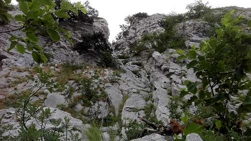
6th pitch - central couloir from S5
7th pitch - 35m, IV+ (UIAA) - Climb the somewhat brushy crack immediately to the right of S6 and continue straight for a few meters. Here you will have to traverse to the left on a inclinated slab and a viciously slick ledge. (There is a piton protecting the last part of the traverse, but its hidden from view until you can almost touch it.) After the traverse the couloir is gradually turning into a chimney (2 more pitons to the left). The last part of this chimney (about 10m) is not protected at all and it takes repeated stemming to get up to a second niche, right above the chimneys exit and S7 (2 pitons + extremly worn metal cable and a small bell).
Parenthesis: Most climbing parties decide to beat retreat after reaching S7 and ringing the little rusty bell. This might be due to the fact that retreat options become increasingly complicated beyond S8, by nature of the terrain. Start early in the morning and you may climb the first 7 pitches, rappel and be still in time for lunch at a nearby restaurant. Not so if you decide to carry on. After the 8th pitch, with VI (UIAA) representing also the crux section of the entire route, you have almost certainly dedicated yourself to a long ascent that is not over with the last pitch of the actual climbing route.
In case you should opt for rappelling down the route from here: 1st rappel is from S7 to S5 (note: this rappel is of somewhat more than 60m and you will walk a few meters on the ledge to S5), 2nd from S5 to S4, 4rd from S4 to S2 and the 4th and last from S2 to the bottom.
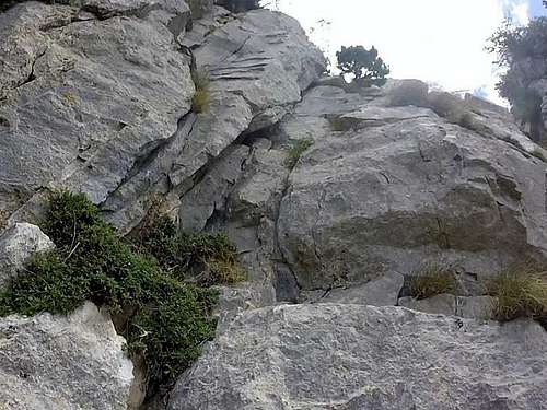
8th pitch - Via della Continuità
8th pitch - 35m, V+, VI (UIAA) - Traverse to the left (2-3m) and climb the dihedron that is protected with several good pitons. - In order to avoid unpleasant rope drag, it is recommendable to leave S7 and prepare a stance right below the dihedron (piton + cam). You might need that extra strenght. - Initially large and around V- (UIAA) it gets increasingly harder higher up. The last part is almost chimney-like and is offering only a large crack for both hands while your feet will have to cope with a slight overhang. There is a very old piece of rope in place, though, that may facilitate the exit that otherwise would require a nasty move and brutal force. (There is only gravel and dirt at the exit.) Once overcome that chimney, climb the grassy slope and look for a large Bosnian Pine that will serve as S8.
9th pitch - III+ (UIAA) - Climb the scarp behind the pine tree and traverse diagonally to the right. Turn slightly left and follow the ragged ridge (III+, 2 pitons) until you come upon an inclined grassy slope. Traverse the slope (about 30m) in direction of a solitary Bosnian pine that will serve as S9.
10th pitch - 60m, n.d. - On this "pitch" there is actual not much to climb. From the pine tree simply walk up the steep slope in direction of a more or less pyramidal shaped rock formation with Bosnian pines on top. Traverse a few meters to the right and look for two steel bolts that mark S10.
11th pitch - 50m, IV+ (UIAA) - This is a quite long pitch on fairly smooth limestone slabs with little protection (3 pitons, somewhat hidden), so you might want to place some protection yourself. Climb the slab to immediately to the right of the edge of the pyramid (to the left of S10 and a young pine tree above!) and point for the Bosnian pines. S11 is the last pine tree, almost on top of the ridge. There you will find a small wooden box with the route-log.
From the end of the route keep following the ridge (easy climbing on instable rocks) for about 100m. Where the ridge gets too steep turn left, descent to the bottom of a large couloir and climb the rocks on the opposite side until reaching the west ridge of Monte Alpi. Follow the ridge to the summit.
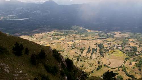
Looking back from the west ridge - Monte Alpi
Descent: From the heap of rocks that mark the summit turn right and start descending on another broad ridge. You will have to loose at least 200m in height. Now point towards the beech forest, enter the forest and keep descending until you come upon something that resembles a trail. For this part of the descent it is highly recommendable to use a GPS track, because its very easy to loose direction and get lost in the thick underbrush. Once on the actual trail keep following it until you hit the scree ramp you climbed to get to the start of the route.
Essential Gear
Although this route is partially equipped with pitons it is highly recommendable to carry complete trad climbing gear. Keep in mind that only the stances of the first 2 pitches have been equipped with bolts. In any case it is advisable to place additional protections and it can become necessary to replace material.Here is a short list of gear that should be in your bag when heading for this route:
- 2 half ropes (60m each)
- at least 10 quickdraws of various sizes
- a number of slings (mostly 60 and 120 cm)
- climbing helmet
- a set of medium and large nuts or wires (+ nut key)
- helpful also a selection of small and medium sized friends (for example BD C4 0.5-2)
- a few meters of accessory cord (for stances and other purpose)
- personal anchor
- ATC, or similar belay device
- a good range of biners
- headlamp (important in case you are starting out late and/or are planing to carry on towards the summit)
- pocket knife (for removing worn out accessory cord and re-equipping stances)
N.B.: Perhaps you will not have to use all these items. But, depending on the current state of the route, you might wish you had brought a little extra gear. In case you should opt for rappelling down the route, however, two 60m half ropes are indispensable once you climbed the 6th pitch which is about 35m.
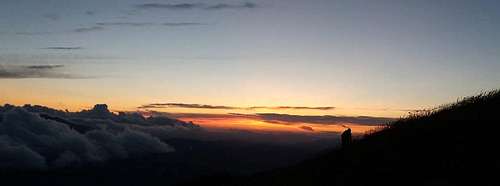
Monte Alpi - Sunset on the west ridge