
-
 2168 Hits
-
 79.04% Score
-
 10 Votes
|
|
Route |
|---|---|
|
|
39.01110°N / 105.517°W |
|
|
Download GPX » View Route on Map |
|
|
Hiking |
|
|
Spring, Summer, Fall, Winter |
|
|
Less than two hours |
|
|
Overview
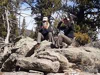
 On the descent
Even if snow or a low-slung vehicle forces you to park lower on the mountain, this is a short and pleasant outing through dense woods to reach an open, rocky summit overlook. While no official trail exists to the summit, a foot path is becoming increasingly defined up the northeastern slopes of this peak. There also area traces of old roads here and there that can be leveraged for easier footing.
Snow Season / Low Clearance Sedan
Roundtrip Distance: 4 miles
Elevation Gain: 1,500 feet
YDS Class: 2
Dry Conditions with Higher Clearance
Roundtrip Distance: Less than 2 miles
Elevation Gain: 1,200 feet
YDS Class: 2
Getting There
 FS 706 is easy to navigate for moderate-clearance vehicles
 Upper parking area
From US Hwy 24 east of Wilkerson Pass
• Head south on Park County 90 (graded dirt).
• Head just 2/10ths of a mile to an un-marked dirt road. (Do not turn onto Pulver Road, which I believe is private.) You may feel at first like you are turning into someone’s rural driveway, but this is a Forest Service road!
o In deep snow or if driving a low-slung vehicle, you may need to park here. Moderate-to-high clearance vehicles will easily reach the upper parking area in dry conditions.
• Follow FS 706, bearing left at junctions, for about 1 ½ miles until it dead-ends in a clearing. Park here.
Route Description
 FS 706 is easy to navigate for moderate-clearance vehicles
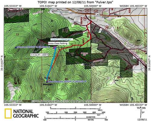
| A note about the route map: I drafted this route map intending to start a snow-season hike from CR 90 (see red line). Due to dry conditions, we were able to easily drive our Jeeps all the way to the highest trailhead at the end of FS 706 (purple dot). The blue line indicates our approximate ascent route. Unfortunately, due to user error, my GPS did not capture our actual ascent/descent route as intended, thus the blue line eliminates some of the realistic meandering of the route. |
From the parking area at the end of FS 706:
While you can bomb up these slopes directly, note that a foot path is developing from the parking area to the summit. This footpath, while faint, may help you avoid the worst of the deadfall and benefit from a slightly more gradual ascent of the peak.
• From the open parking area, head south-west through aspen to begin the ascent.
• A faint footpath will be noticeable in the right conditions to the astute eye.
• Continue the approximately 1 mile ascent through the woods to the summit of Pulver Mountain. It’s that simple.
• The highpoint resides on the far southeast end of the summit plateau and is wide-open and rocky.
• Pay attention to your descent route through the trees to ensure you return to your vehicle efficiently, and that you don’t inadvertently veer off onto private property or into an unfriendly drainage.
Essential Gear
 |  |  |
Hiking equipment appropriate to the season and a higher-profile vehicle (if you wish to drive to the upper trailhead) are the most crucial pieces of gear to have. As always, carry a map and compass or GPS. Even though this route is relatively straight-forward, white-out conditions and/or dense fog can do bad things to the human sense of direction.