
|
|
Route |
|---|---|
|
|
36.56390°N / 118.2911°W |
|
|
Hike/Scramble |
|
|
A long day |
|
|
Class 1 with a class 3 summit block |
|
|
Approach
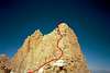
Take the Mt. Whitney Trail to Trail Crest, and go north past the junction with the John Muir Trail. Mt. Muir is difficult to make out from the west side, but it is the highest point on the ridge just past the JMT junction. Look for loose sand/scree on the right side of the trail, and indications of cross-country travel. There are no signs making the start of the route, so keep your eyes open.
Route Description
Leave the Whitney Trail and climb upwards, following the most obviously used routes. There is no "correct" route, so don't worry that you are off route unless the climbing gets harder than class 3. Most of the route from the maintained trail is class 2 until you near the summit.
Just below the summit there are several easy class 3 moves needed to reach the summit. Take your time in route-finding to keep it from getting more technically difficult.
It is less than 300 feet to the summit and can be done in less than 20 minutes, but fewer than 1% of those climbing Mt. Whitney choose to climb Mt. Muir. There is a Sierra Club register at the summit filled with small notebooks and scraps of paper this somehow more fulfilling to add your name to than the large-format log found at Mt. Whitney's summit.
 |
Essential Gear
None required. I climbed it in tennis shoes.
Miscellaneous Info
If you have information about this route that doesn't pertain to any of the other sections, please add it here.