Overview
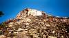
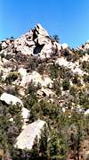
As the highest mountain in the Prescott area, this obscure little gem has some unique and classic history scattered about it's craggy outcrops. Granite mountain boasts adventurous scrabbling and high angle 5th class ventures-in-the-sky. There are no established trails to the summit. But of the trails provide, most tend to ascend skyward. A vague climbers trail was established near the marker of Trail 261.
As far as rock climbing goes, it is the premier proving ground for inspiring traditionalists. Most routes require gear ascents but there are a good number of fixed gear climbs on the Swamp Slabs. The mountain offers semi-arid climate which produces moderate summers and mild winters. It has a longer climbing season then most climbing areas in the United States. Crack and face climbs are the norm throughout Granite Mountain. Most climbs range from 100 feet to 500 feet in length, none of which climb to the summit. The mountain is broken down into 3 sections for the purpose of locating climbs: the Swamp Slabs, the Middle Section and the Right Section.
Getting There
From the town Square of Prescott, drive west on Gurley Street and turn right onto Grove Avenue. Follow Grove, which turns into Miller Valley Road, and turn left onto Iron Springs Road. Follow Iron Springs Road 3 miles and turn right onto unpaved road just after Granite Basin Recreation Area sign. At this point follow umpaved roads 3 to 4 miles to Trail 261 trail-head.
Red Tape
The standard fee of $2.00 parking fee applies
When To Climb
March through June and September through November.
NOTICE: As of March 2002, the National Forest Service has issued a closure restriction until further notice. This closure is part of a wilderness management program that will study the environs of birds of prey. Access Fund is currently moving to reopen talks with the National Forest. Please respect this current closure and preserve the future of this natural resource. The page maintainer will update this section upon any changes or revisions.
Camping
Unlimited camping in and around the Toiyobe Wilderness Area and National Forest. Maintain a low profile if your intenstion are to camp near the trailhead of Trail #261.
External Links
- Arizona Backcountry Climbing Beta
Provides beta on Cochise's Stronghold, the Camelback, Granite Mountain and other climbing areas in and around Prescott and the "outer reaches".


Scott - Jun 23, 2005 2:34 pm - Hasn't voted
Untitled CommentFYI: You may want to replace it.
bcramer - Aug 13, 2008 10:41 am - Hasn't voted
Updated road, parking conditions, peregrine falcon closure and guidebookGranite Basin Rd. off Iron Springs Rd. is paved all the way in to a gated loop road with several parking lot options. The gate is open at 6am-9pm in the summer and 7am-6pm in the winter. The Playa or Metate day use lots are best for climbers. Hike TR 261 1.25 miles to Blair Pass and turn right uphill, at the right end of the second major switchback near a large rock outcrop pick up the climber's trail that wanders down through some cactus at the start. This trail leads up and right towards the Flying Buttress. About half way there is a trail that leads straight up (steep) towards the left edge of the Swamp Slabs area (it begins with a big step just left of a pine tree). There is still a 2 dollar fee, but parking is free Wed.s or everyday if you can display a National Park pass. The Mountain is open for climbing from July to Feb., a peregrine falcon closure is usually in effect from Feb. to mid July. Call the forest service office or check their website for updated restriction notices. There is a fold-out style topo available. "A Climber's Topo Guide to Granite Mountain" by Bill Cramer (that'd be me). You can pick it up in town at Granite Mt Outfitters at 320 W Gurley or Manzanita Outdoors on Hwy 69 (in Frontier Village Shopping Center). I think the REIs in Phoenix may still have it too, but I haven't kept up on their inventory of it lately.
hgrapid - Oct 30, 2018 8:17 am - Hasn't voted
Latitude and Longitude?There is no latitude and longitude. Will you add it?