
|
|
Route |
|---|---|
|
|
39.11400°N / 106.493°W |
|
|
Easy Scramble |
|
|
Half a day |
|
|
class 2 |
|
|
Getting There
The North Lake Creek Trailhead provides access to Casco Peak's west side, via the Lackawanna Gulch The trailhead is right off of Colorado 82, 19 miles west of the U.S. 24 - Colorado 82 junction, at the base of Independence Pass. Locate the tiny, unmarked turnoff just 100 yards before you reach the first major switchback on Independence Pass. There is ample parking space.Approach
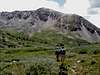
Walk a quarter mile north from the North Lake Creek Trailhead and cross the North Fork Lake Creek to the east. Important note: Through June, the creek may be uncrossable due to heavy spring run-off.Hike generally east on an old mining road. The road switches back first to the south, leaving you to doubt its direction. But follow the road into the Lackawanna Gulch. After a half mile or more the road becomes a trail, while you continue up the gulch past a couple of old prospector cabins. There are lots of possibilities in this area for a secluded overnight camp. After a good mile, look for a crossing to the north side of the creek before it forks, and into the north fork of Lackawanna Gulch. This area is swampy for a brief ways and could be problematic in wet weather. We crossed at the first major break in the trees.
 Above the creek
Pick up a strong trail that leads northeast, above the north fork. The creek in this area runs through a gorge that is 100 feet deep in places. Pass another old cabin and on to flatter terrain as you pass under Mount Champion on your left. By now you should be well above the creek. The creek makes a huge sweeping curve around to the right, eventually terminating under Casco Peak. Continue to gain altitude as you stay on the outside of the curve.
You pass under the mile long, north-south ridge connecting Casco Peak with Frasco Benchmark. Climb toward Casco, to the base of the shortest scree slope under the ridge. You want to minimize the time you have to spend on this loose rock... on your ascent. It is nicknamed "Fiascol". Spread out from your climbing partners, and ascend to the ridge, 300 feet above.
Route Description
 Special views
Once you reach the saddle, climb to the summit (south) along the ridge. Peer down to your right once in awhile for some special views.
On your way back, you may take an earlier exit from the ridge, to catch more scree on the way down. Look back toward the summit, to see the huge face of a bear in the rocks. (Sorry, I didn't get a photo of it.)