
-
 28514 Hits
-
 91.45% Score
-
 35 Votes
|
|
Mountain/Rock |
|---|---|
|
|
39.11400°N / 106.493°W |
|
|
Hiking, Mountaineering, Scrambling, Skiing |
|
|
Spring, Summer, Fall, Winter |
|
|
13908 ft / 4239 m |
|
|
Overview
Casco Peak is the 69th highest peak in Colorado and part of the Centennials. People seeking to climb the 100 highest must climb this peak. It is part of the spectacular Sawatch Range which is known for its many 14,000 ft peaks and broad gentle slopes which often make great backcountry skiing destinations. Casco is right across a basin from the highest peak in Colorado, Mt. Elbert therefore it is not climbed very frequently. You can enjoy a beautiful day of solitude in climbing this mountain while looking across the valley to see a herd of people on Mount Elbert. Casco is often coupled with a climb of Frasco Benchmark (13876 ft) and French Mountain (13940 ft). French Mountain is a ranked peak but Frasco Benchmark is not considered an official peak since it has less than 300 feet of clean prominence. Nevertheless the ridge hike from Casco to Frasco Benchmark and then on to French Mountain is a classic Colorado ridge hike. While you enjoy a peaceful snack on the summit see if you can spot the myriads on top of Elbert!
 Casco Peak Casco Peak |  Casco Peak N Ridge Casco Peak N Ridge |  Casco Reflection Casco Reflection |  Casco Peak SW Ridge Casco Peak SW Ridge |
Getting There
The book by Gerry and Jennifer Roach titled Colorado's Thirteeners from Hikes to Climbs has excellent driving and route descriptions. I highly recommend this book if you plan on doing much in Colorado. If you want to climb Casco Peak from the north (Halfmoon Creek) follow these directions. From Leadville drive a couple miles southwest on US 24. Turn west (right) onto CO 300 and measure from this point. If coming from the south in Buena Vista, go north on Highway 24 and turn left onto CO 300. Go 0.7 miles west to a left turn onto Lake County 11 (gravel road). Take a right turn at 1.8 miles onto a signed gravel road toward Halfmoon Creek. Pass Halfmoon Creek and Elbert Creek campgrounds as well as the Mt. Massive Trailhead and overflow parking area. At mile 9 reach the FS110-FS1103A road junction where passenger cars will need to park. 4WD vehicles can continue much further in summer, otherwise you'll have to walk the road. The drive up the road to the trailhead for Casco is pretty rough but can be done in a high clearance 4WD vehicle without any special modifications or equipment. Continue up this rough road and do an easy ford across a Halfmoon Creek (maybe not so easy in spring runoff-watch out!). Follow the road as it switchbacks up a hill, lots of rocks in the road here. After about a mile the road crosses another creek at about 10,800 ft. Most people park at this point, there are a couple of pullouts that can fit maybe 3-4 cars total. If you were gutsy you could ford the creek and continue but stock vehicles will have a tough time going much further as the road gets much worse. There is a 300 foot section that is especially bad but if you make it up that, you can drive all the way into the basin that is surrounded by French, Frasco, and Casco Peaks on the west side and Mt. Elbert on the east side. The road ends at the old Iron Mike Mine at 12,800 feet but if you get this far the climb becomes merely a short jaunt worthy of maybe an hour or two!
If you want to climb Casco Peak from the south and west (Independence Pass Highway 82) follow these directions. From Leadville head south for 14 miles on Highway 24 with great views across the Arkansas River valley towards all the Sawatch Peaks. Turn right (west) onto Highway 82 with signs for Independence Pass. Continue on this road for 19 miles as it weaves around many curves and through beautiful aspen groves. Just a few feet before the first hairpin switchback turn right onto a dirt road with signs for the North Lake Creek Trailhead. Puul off here and drive a few feet to the parking area at 10,780 feet in elevation. Mount Champion is the broad peak you can see up the valley from the trailhead.
 Casco Peak under snow Casco Peak under snow |  Casco Peak Casco Peak |  Casco Peak Casco Peak |  Casco Peak N Ridge Casco Peak N Ridge |
Route Options
There are two ways to approach this route. Probably the most popular is by the Iron Mike Mine (South Fork Halfmoon Creek) road. Either walk or drive this road (4WD) to the Iron Mike Mine. From the old mine, hike west up the talus slope aiming for 13,240 foot Fiascol which is the saddle between Casco Peak and Frasco Benchmark. Once at the saddle, turn south and follow the ridge up for 0.3 miles to the summit, avoiding any difficulties on the left (east side). The summit is a small rocky point. The second way to approach is from Highway 82 at the North Lake Creek Trailhead. From the small parking area just before the first big switchback in the highway, walk a quarter mile north and cross the North Fork Lake Creek where possible to its east side. This crossing has proven very difficult in early season. Locate an old mining road and follow it generally heading east as it switchbacks up through forest. Although it heads south for a bit don't be tempted to leave this road. Eventually, it heads into Lackawanna Gulch where it continues another half a mile or so and becomes a trail. Continue up the gulch following the trail as much as possible. It stays on the left (north) side of the creek most of the time. When you come to a distinct fork in the valley at 11,600 feet be sure to take the left (north) fork. Continue up along the base of Mount Champion as the trail peters out, passing treeline and cross the creek at around 12,200 feet in elevation to its south side. Climb up gentle talus above the creek veering more south as the valley curves. The peak you see much of the approach in this valley is actually the west face of Frasco Benchmark. Just as the valley turns completely south, locate Fiascol and turn to the left (east) and aim for this 13,240 foot saddle. The final 200 foot climb to this saddle is on dangerously loose rock and extreme caution should be taken on this slope. Once at the saddle finish the last 700 feet up the north ridge.
 Starting the N RIdge Starting the N RIdge |  Summit scramble Summit scramble |  Casco Peak N Ridge Casco Peak N Ridge |  Traversing from Frasco Traversing from Frasco |
Southeast Ridge - Class 2
This ridge is typically approached from the Iron Mike 4WD Road via Halfmoon Creek Road. Either walk or drive to the old mine and instead of heading for the Casco/Frasco saddle head southwest for 0.4 miles over gentle talus aiming for a small rib coming down from the southeast ridge of Casco Peak. Mount this rib and continue up another quarter mile to the southeast ridge reaching it at 13,300 feet. Climb an 0.3 miles up the easy ridge to the summit.
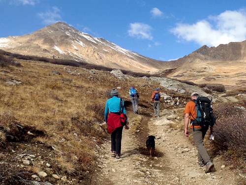
Hiking the Iron Mike Road
This route allows you to summit all three peaks. Casco, Frasco and French are all in close proximity and make a classic Sawatch ridge run. It is best to approach from the Iron Mike Mine for this route. Ascend Casco Peak by either the north ridge (passing by Fiascol) or the southeast ridge and from the summit, descend the north ridge 700 feet to Fiascol. The next part is the most difficult but basically climb north up the ridge to Frasco Benchmark avoiding some towers on the west side of the ridge. The traverse from Frasco to French is very straightforward. Descend the South Slopes route on French Mountain back to the Iron Mike Mine.
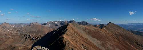
The three peak traverse from Casco Peak
Map
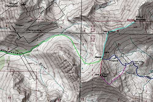
DARK BLUE: Iron Mike 4WD approach from CO 300/Halfmoon Road - Class 1 and 2
GREEN: Lackawanna Gulch Approach from North Lake Creek TH - Class 2
RED: North Ridge Route - Class 2
PINK: Southeast Ridge Route - Class 2
LIGHT BLUE: Casco/Frasco/French Traverse - Class 2+
When To Climb
This peak is a really nice summer hike. The flowers in the basin are beautiful and the surrounding peaks make for great views in all directions. This hike would be fine in the fall until the road gets snowed in. According to Roach the winter closure varies from the start of the Halfmoon Creek road, only 1.8 miles from US 24 to the Halfmoon Creek campground 5.6 miles from US 24. Independence Pass is gated in the winter 3.5 miles from the North Lake Creek Trailhead which will add 7 miles round-trip for the approach from the southwest. This peak would be a long haul in the winter and the avalanche dangers are commonly pretty bad. Be prepared for full winter travel which includes bringing warm clothing, ice axe, crampons, winter boots, shovel, probe, beacon, face and eye protection, and maybe even bivy gear in case you get stuck overnight.
| Casco Peak under snow | Casco Peak | Casco Peak | Casco Peak N Ridge |
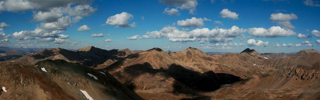
The Summit View
  |
Camping/Red Tape
There is camping at the Halfmoon Campground and the Elbert Creek campgrounds. This would be fee camping and it gets really crowded in the summer, so it's best to get there early. There are also places along the road that you can find to use free of charge. Look for pull-offs that don't have a car in them. There are also some free camping spots if you want to drive past the FS110-FS1103A junction at mile 9, probably about a mile or two continuing up the road. Free camping is also available at the North Lake Creek Trailhead. There is no red tape to speak of here. Casco Peak lies on open national forest lands.
San Isabel National Forest1920 Valley Drive
Pueblo, CO 81008
(719) 545-8737
External Links

Iron Mike Mine