-
 13842 Hits
-
 78.27% Score
-
 9 Votes
|
|
Route |
|---|---|
|
|
41.40900°N / 122.223°W |
|
|
Mountaineering |
|
|
Spring |
|
|
One to two days |
|
|
Getting There

Route Description

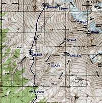
From the parking lot head north directly towards Mt. Shasta. The trail starts next to the restrooms. In about 200 yards the trail crosses over the small ridge on your left and you drop a few feet down into a gully that heads north towards Mt. Shasta. This is the southern end of Avalanche Gulch. Follow the gulch on the well packed trail of the other climbers, skiers, sightseers, and snowshoers.
You climb about 1,000 ft in about 1.5 miles to Horse Camp. Horse Camp is kind of hidden in the trees to the left just below tree line. If the spring is running at Horse Camp this is a good place to fill your water bottles.
From Horse Camp you have a magnificent view of Mt. Shasta, but you can’t see the summit of Shastina. You can see a rounded ridge line (point 9,487 on the topo’s) off to the left or north about 1.5 miles away. That is your objective for now. Head towards that rounded ridgeline on the horizon.
Turn left as you pass the cabin and head through a popular camping area towards a small ridge ahead. This ridge is steep in spots and when the snow is soft it can be a problem climbing. Climb about 300ft to the top of this wide ridge. On the other side you will see a large drainage coming off of Casaval Ridge. This is Giddy Giddy Gulch. Start a climbing traverse to your right. You want to cross this wide drainage, gain elevation, and climb the ridge across the drainage.
This next ridge is the lower portion of Casaval Ridge and it is not technical. Work your way over the ridge as you continue to climb. On the far side of Casaval Ridge you should be at about 8,800 ft in elevation and you can see point 9,487 above you on the next ridge. The ridge from point 9,487 crosses over to Casaval Ridge above you. Head up this drainage to the saddle on the ridge that separates point 9,487 and Casaval Ridge.
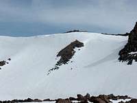
Once you gain the saddle you can see Hidden Valley about 250 ft below you and you can also see Shastina in all her glory. There are 2 ways to get down into Hidden Valley. One is to follow the ridgeline west and then down a steep slope on the west end of the ridge. Follow this end of the ridgeline around to Hidden Valley and enter the valley at the south end of this drainage. The other way is to take the direct approach and find a good spot to plunge off the ridge down into the valley. If you are lucky you will be able to follow the footsteps of others. In high snow years, there could be a large cornice on this ridge that may make the direct approach more problematic. There are several bivy sites along the top of this ridgeline if you want to camp there for the night instead of finding a place in Hidden Valley.
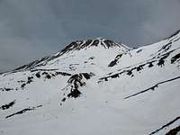
You can see the rest of the entire route directly in front of you for Shastina. Take the shortest route and head directly at the summit. The summer time route follows the Cascade Gulch drainage all the way up to the Shastina/Shasta saddle and then follows a steep talus ridgeline up to the summit. When there is snow in the valley, the route is much easier. I camped in Hidden Valley and the next morning headed straight for the summit.

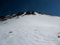
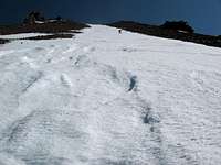
The last chute going from about 11,000 feet up to 11,800 ft didn’t look very far, but it was steep and took quite awhile to get to the top. Once you cross the upper lip of the old caldera, the slope eases up and it doesn’t take long to get to the summit. The last little rocky knob at the summit is steep again and I’ve seen people go directly up it, around to the left and up, and around to the right and up. Depending on conditions, chose the route that is best for you. A word of caution, there is some exposure if you go to the left and then up the back side of the knob.

The overall hike is only about 10 miles, but the elevation gain is 5,880 ft with the up and down getting into Hidden Valley.
Essential Gear