
-
 5195 Hits
-
 86.85% Score
-
 23 Votes
|
|
Route |
|---|---|
|
|
46.42310°N / 13.38688°E |
|
|
Hiking |
|
|
Spring, Summer, Fall, Winter |
|
|
Half a day |
|
|
Hike and Scramble |
|
|
Overview
 Monte Cimone Summit Monte Cimone Summit |
There are two takes on the Normal Route to Monte Cimone, which share the easy parts at the beginning and the final ascent along the Monte Cimone east ridge. The middle part is completely different in character but even so it is hard to tell which route is the more difficult one. The eastern route of the two, described here by Vid, touches upon the most incredible of saddles, Forca Vandul, and has a steep secured section to the summit of Pizzo Viene. The western route, described here, heads up very steep grass slopes along which views develop with each step.
But there's no need to decide between the route as you can combine them in a nice round trip with the Monte Cimone Summit as its highest point. I would suggest to use the western route for ascent, since the steep grass slopes can become quite dangerous in wet conditions.
Getting There
 Altopiano di Montasio with Monte Cimone
The starting point for the route is at the Case di Pecol on the Altopiano del Montasio.
From the South
Take motorway A23 from Udine to the exit Resiutta, where you turn onto SS13 east. At Chiusaforte turn onto SP76 to Sella Nevea. In Sella Nevea turn left onto the narrow mountain road which leads to Predil.
From the North
From Austria take motorway A2 which at the border to Italy turns into A23. At the exit Tarvisio turn onto SS54 to Passo Predil. At the intersection with SP76 turn right in the direction of Sella Nevea.
Route Description
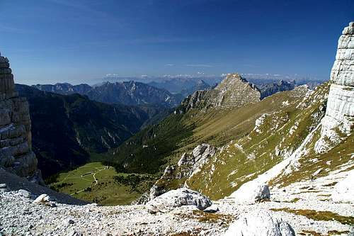
 View into Canale di Raccolana
- Start altitude: 1502m
- Summit altitude: 2379m
- Prevailing exposure: S
- Type: 4h one way
- Protection: None
Start out from Pecol along the lower of the two roads, the one which keeps level, leading westward. You will reach a farm building before which you have to turn left and down, passing the building on its western side underneath. Here finally the road turns into a path, the Alta Via, which, keeping level follows all the dents, valleys and buttresses of the slopes of Monte Zabus above. After a while (30 minutes) the route to Forca Vandul turns off right. But you need to follow the Alta Via for another hour, negotiating the south slopes of Pizzo Viene. Finally after a long right turn you reach the point, where the ascent route turns off right into the Viene Gully.
 Pizzo Viene S Buttress Pizzo Viene S Buttress |  Pizzo Viene S Buttress Pizzo Viene S Buttress |  Monte Sart Monte Sart |
Gully might be too harsh a word for the steeply rising slope. Its sides are rather shallow, only to the east there is the southernmost buttress of Pizzo Viene. The path avoids switchbacks wherever possible and rather heads up directly in north-easterly direction. After half an hour of vey steep climbing the route grows more level above the south buttress of Pizzo Viene, turning into a high valley which heads towards Forca Viene, the saddle between Pizzo Viene and Monte Cimone. If you are lucky you will come across whole herds of Ibexes in this valley.
 Herd of male Ibexes Herd of male Ibexes |  Baby Ibex Baby Ibex |
Another half hour will get you there. However, the saddle is separated from the valley by a deep crevice which you have to pass either to the east or west in order to see into Val Dogna on the other side.
 Jôf di Montasio seen through Forca Viene
The route from Forca Vandul joins here, descending from Pizzo Viene. Both routes now head up onto the Monte Cimone eastern slope avoiding the east ridge on its southern side. There is a small grade II climbing section, not more than 10m, but tricky in wet conditions. Above this section the route joins the ridge, following at all the way up the summit and offering great views into the jumble of rocks beneath the north faces of Cimone and Jôf di Montasio.
 Monte Cimone east ridge Monte Cimone east ridge |  Monte Cimone fore summit Monte Cimone fore summit |  Jôf di Montasio through the clouds Jôf di Montasio through the clouds |