
|
|
Mountain/Rock |
|---|---|
|
|
46.82729°N / 10.10875°E |
|
|
Mountaineering |
|
|
Spring, Summer, Fall, Winter |
|
|
10764 ft / 3281 m |
|
|
Overview
Piz Fliana is an important and beautiful mountain in the southern Silvretta group, located between the highest (Piz Linard) and 3rd highest (Piz Buin) Silvretta mountain.It offers worthwhile ascents on all sides, and is also a rewarding vista point.
Piz Fliana's 1st recorded climb was in 1869.
 Piz Fliana (center) and Piz Buin (right), through the morning mist from Val Tuoi
Getting There
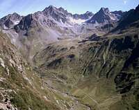 Val Tuoi
There are 2 huts just on opposing feet of Piz Fliana: Tuoi hut, 2250 m, in valley Tuoi east of the mountain; and Marangun hut (no warden), 2025 m, in valley Lavinuoz west of the mountain, between Piz Fliana and Piz Linard.
Tuoi hut is reached by a 2.5 hours walk from the village of Guarda, 1600 m, in lower Engadin. There is a payable parking lot about 100m before Guarda (8 CHF 1st day, 2 CHF every following day, as of 2008).
Marangun hut is reached in a similar walk from the village of Lavin, 1450 m and neighboring upriver Guarda.
There is a changeover between the 2 huts using the Fuorcla d'Anschatscha pass, 2850m (essentially pathless, see below).
For getting to Lower Engadin see Silvretta page.
Red Tape
No ranger-surveilled regulations.Go and leave no traces, that's the philosophy.
Particular plants may be protected.
Routes
 Plan Mezdi east pano - Piz Buin left, Piz Fliana right
 Plan Mezdi area pano
 P. Fliana from P. Buin
 Ascending Fuorcla d'Anschatscha
 S-flank
- North face and NW ridge:
From the saddle below the Plan Mezdi rock island, traverse the steep glacier below the NW-ridge leftwards to reach the upper, easy part of that ridge. Beware of crevasses, also a Bergschrund (rimaye) has to be crossed (compare the pic beside taken from top of Piz Buin in august 2006). Climbing grades I and II UIAA are required. This route is also done in winter/spring as a ski tour. - East face:
Via the east firn (albeit its name a still crevassed glacier) to the upper NW-ridge. The glacier is reached from Tuoi hut through steep pathless gravel slopes, staying south of the shoulder called Cronsel (between Piz Buin and Fliana). The 1st part of the glacier is relatively steep and may be blank in summer. - East ridge:
From Tuoi hut through the trackless grass slopes south of the hut, westward up in direction of the saddle called Fuorcla d'Anschatscha (the 1st 200 m of altitude are very steep!) till about 2450 m. Turn right (north) to a saddle at about 2520 m, which marks the beginning of the ridge. This point may also be reached from north. The steepest part of the ridge is between approx. 3100 m and 3200 m. Climbing in grade II is required. - South flank:
Easy, but rugged and somewhat confusing mixed terrain. Mostly interesting for the descent. Ascent starts and descent ends in Fuorcla d'Anschatscha. Also a scree gully a bit west below Fuorcla d'Anschatscha may be used. - Traverse via Piz Tiatscha:
A highly praised, but strenuous route is the traverse to Piz Fliana from west (Marangun hut) via Piz Tiatscha, 3051 m.
 Looking down to the loophole
 Piz Linard NE ridge
Fuorcla d'Anschatscha, 2850 m, is a saddle mediating between Val Tuoi in the east and Val Lavinuoz in the west, and hence between Tuoi hut and Marangun hut. Despite of its beauty rarely used and without path - you will easily be alone on this route! The Val Lavinuoz side of this saddle is much easier than the east side, due to the steep grass slopes in the lower part of the latter. Across Val Lavinuoz, Fuorcla d'Anschatscha provides a splendid view on the E and N faces of Piz Linard.
BEWARE! When descending to Val Tuoi in foggy conditions the right loophole to the steep section may be very difficult to find!!
External Links
Homepage of Tuoi hut (Chamanna Tuoi)Interactive Swiss map, centered on Piz Fliana