Overview
![Unicorn Peak]() Unicorn Peak
Unicorn Peak
The Griff Creek Trail is a short, steep ascent from the Elwha River ranger station in Olympic National Park. While out in Port Angeles on business I was able to set aside enough time to check out a few things in the park, including this one.
Total one-way mileage is 2.8 miles with about 2900 feet of elevation gain. The starting point is the parking lot at the Elwha River Ranger Station at 390 feet elevation. The highlight of the trail is an observation point at the 1.6 mile mark that has great views of the Elwha River Range, parts of the Bailey Range in the distance, and the Griff Creek drainage down below.
To the observation point
![Olympic Old Growth]() Olympic Old Growth
Olympic Old Growth![Pacific madrone]() Pacific Madrone
Pacific Madrone
Though the trail is named after Griff Creek, I never saw the creek from the trail. The trailhead at the ranger station lies near where the creek flows into the Elwha, but the trail ascends rapidly through dense forest in the Griff Drainage, avoiding the creek. You’re nowhere near water, so be sure to pack what you need.
I started out mid-morning (9-ish) on a beautiful winter day in early March. The skies had scattered clouds. It drizzled off and on, falling as rain at lower elevations and light snow at higher elevations. At the end of the official trail - - let’s call it “Griff Creek Gap” - - there was a strong wind blowing out of the south carrying significant snow.
![Upper Elwha Valley and Bailey Range]() View to south from observation point
View to south from observation point![Mount Carrie from Elwha River Range]() Mount Carrie from Observation Point
Mount Carrie from Observation Point
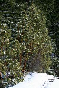
The trail starts with a gradual ascent through an old-growth forest with the thick understory typical of the Olympic Peninsula (and most of the Pacific Northwest). As I was enjoying being back in the Pacific Northwest, the trail quickly became moderate in steepness, with long switchbacks. My first animal sign here was a mountain lion urine dump, with its characteristic little pile of dirt where the cat had covered it up. The dirt was on top of the morning snow, so obviously the lion was close.
A little later, I saw snowshoe hare and bobcat footprints for several hundred yards. Both were following the trail, and the bobcat’s prints were more recent than the rabbit. But I never found any evidence of the end of the story.
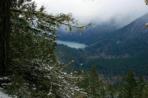
These switchbacks continue to the 1.6 mile point, where there was a sign pointing to the observation point on the left. This is a beautiful, bare promontory sticking out to the south. It’s at 1875 feet. The best views look south and southwest over Elwha River Valley and Lake Mills to the Bailey Range.
To the left are views along the Elwha River Range. Unicorn Peak (5,100) is the most distinctive of these but you can also see Griff Peak (5,120 feet). Below you is Griff Creek Valley, consisting of dense forest.
Most people will find this to be an excellent stop to rest, have lunch, and turn around. But SPers won’t stop here.Beyond the observation point
![Glines Canyon Dam]() Lake Mills and Glines Canyon Dam
Lake Mills and Glines Canyon Dam
I returned to the trail and continued to head uphill. You pop over the crest of the ridge to continue the climb on the north side of the Elwha River Range. At about 2.4 miles and 2300 feet there is an inconspicuous viewpoint peeking through the forest to your left..
From there I continued on the uphill traverse for a third of a mile and about 200 feet of elevation. Our cougar friend had already hiked this stretch of the trail that day, with prints in the light snow and a pile of scat. There was also a set of deer prints but the lion did not follow those for some reason.
After this traverse, we return to some serious switchbacks - - the trail ascends the last 800 feet in 0.5 miles (that’s a 30% grade if you’re keeping score at home). An elderly gentleman who lives in the area and clearly hikes the mountains all the time totally smoked me on this stretch, passing me and keeping an excellent, even rhythm up the hill. He was the only other human I saw on the trail.
The maintained trail ends at Griff Creek Gap, where the weather turned less pleasant with a strong windy and light snow. Both the speedy gentleman and a park ranger told me there is good scrambling up the ridgeline from that point, but that will have to await another day.
The first part of the descent was quite slippery when wet, so be advised about that. The snow died down as I descended, and got to watch two mule deer chew their cuds near the end of the trail.


Comments
Post a Comment