
-
 8245 Hits
-
 84.27% Score
-
 18 Votes
|
|
Mountain/Rock |
|---|---|
|
|
43.99595°N / 10.33748°E |
|
|
Hiking, Via Ferrata |
|
|
Spring, Summer, Fall |
|
|
4196 ft / 1279 m |
|
|
Overview
 Monte Procinto and Monte Nona in front of Monte Corchia and Pania della Croce Monte Procinto and Monte Nona in front of Monte Corchia and Pania della Croce |
The Alpi Apuane are divided into two large sectors, one in the north, one in the south. Both are separated by the barrier of Pania della Croce and its neighbours and are as different as is possible at such a small distance. While the northern sector consists of dolomite-like marble mountains which rise up to heights approaching 2000m the southern sector is low and covered by forests. Here few mountains reach 1400m and the area is best known for its rugged, karst-like appearance. Mountains often form summit plateaus, which drop of to at least one side by massive drops of several hundred metres. In between you can find wonderful towers, sometimes brittle, sometimes made up from high quality limestone. In between there are gorge-like gullies, often with caves and/or rock windowsat their sides.
 |  | 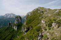 |  |
One of the easiest, yet most spectacular mountains is Monte Nona. On its easiest route its summit can be reached by a 30 minute hike from Rifugio Matanna. Yet, even though the summit views are exceptional, the main attraction is cannot be found on the top of the mountain. In fact it is barely visible from there. Monte Nona is best known for its much smaller satellite, Monte Procinto. The latter is a small square tower, located to the west of Monte Nona's summit. Together with a couple of even lower towers, the Torri del Prato, it prolongs the north face of the mountain towards the west. A ferrata has been established on Monte Procinto's east face, which is rumoured to be rather difficult. Also, protection is old and rusty. I didn't climb the ferrata due to lack of time but followed the line with my from below. It follows the south-eastern edge of the tower, before venturing out onto the south face. Here a traverse takes you to a chimney, which then leads to the wooded topmost part of the tower. The climb looks very animating.
 |  |  |  |
Monte Nona, on the other hand, also displays massive faces to its north and west. Especially the north face drops into the valley with a vertical drop of several hundred metres. Most likely the face has been climbed though it appears rather sharp-edged and brittle. The west face, which is every bit as impressive, is covered with trees, however, so that most of it remains hidden. The most famous view of both mountains can be seen from the saddle between Monte Nona and neighbouring Monte Matanna in the south. Thanks to the short and easy access from Rifugio Matanna this place can be quite crowded on sunny weekends.
 |  |  |
In spring the east slopes of Monte Nona are home to many species of orchids and other wildflowers. This in itself is worth a visit.
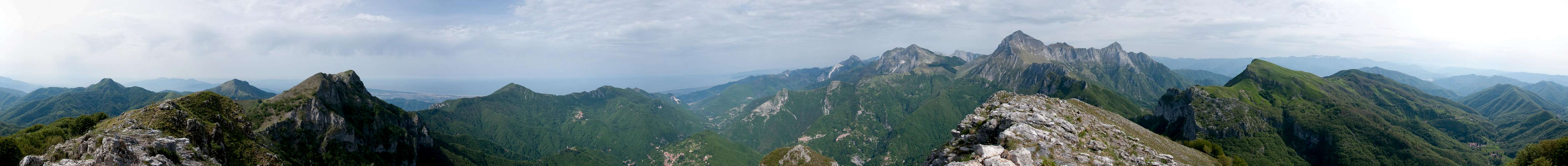
360° Summit Panorama
  |
Getting There
 Monte Procinto Above Stazzema and Pania della Croce
There are two possible trailheads, one at Stazzema directly to the north-west of Monte Nona, the other at Rifugio Matanna to its immediate south-east. From the latter trailhead the climb to the summit of Monte Nona is a 30 minute affair.
From Pisa or Firenze (Florence) the itineraries are as follows:
- Stazzema Trailhead:
- Take motorway A11 to the coast
- Switch to motorway A12 north
- At the exit Pietrasanta take SP9 through Seravezza to Stazzema
- Rifugio Matanna Trailhead
- Take motorway A11 to Lucca
- Switch to SS12 in direction Abetone
- At Borgo a Mozzano switch to SP2
- After 10km turn left onto SP37 through Fabbriche di Vallico and follow the signs to Matanna
Red Tape
 Orchis militaris
The Parco Naturale delle Alpi Apuane was established in 1985 to protect the nature as well as culture of the area within which the Alpi Apuane are located. Its overall size amounts to almos 21000 ha. A constant challenge is the presence of roughly 300 marble quarries which their impact on the environment. A hiker might easily find himself inside one of the quarries and is requested to follow signs and rules there (especially for the start of the western route).
The park's official website
Accommodation
Accommodation is relatively easy to find along the coast of the Tyrrhenean Sea. Viareggio, Massa, Carrara and La Spezia offer lots of hotel rooms as well as campgrounds. Either book them by travel office or go for a google search.On the other hand, to stay closer or within the range you can make use of Agriturismo, farms, which offer food and lodging. The site of the Natural Park has a selection of all kinds of accommodation of the area:
Weather Conditions
Maps & Books
Maps
- Alpi Apuane - Garfagnana
Kompass Verlag
1:50000
ISBN: 3-85491-852-6
- Geological Map Parco delle Alpi Apuane
1:50000
L. Carmignani, P. Conti, L. Disperati, P.L. Fantozzi, G. Giglia and M. Meccheri
Maps Online
Books
- Tuscany North / Toskana Nord
Wolfgang Heitzmann / Renate Gabriel (translation: Gill Round)
Rother Verlag
ISBN: 978-3-7633-4812-1 (English)
ISBN: 978-3-7633-4115-3 (German)
- Guida al Parco delle Alpi Apuane
Edited by: Giuliano Valdes
Series: Guide Felici
ISBN: 88-88327-91-6
- Guida all’Alta Via del Parco delle Alpi Apuane
Angelo Nerli
Felici Editore Srl
ISBN: 88-6019-006-1