
-
 7921 Hits
-
 80.49% Score
-
 12 Votes
|
|
Route |
|---|---|
|
|
46.63783°N / 12.96065°E |
|
|
Hiking, Scrambling, Via Ferrata, Canyoneering |
|
|
Summer, Fall |
|
|
Half a day |
|
|
Medium hard ferrata (C) |
|
|
Overview
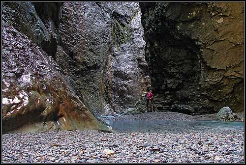
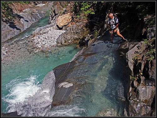
The "First Darkness" - the gorge closes almost completely
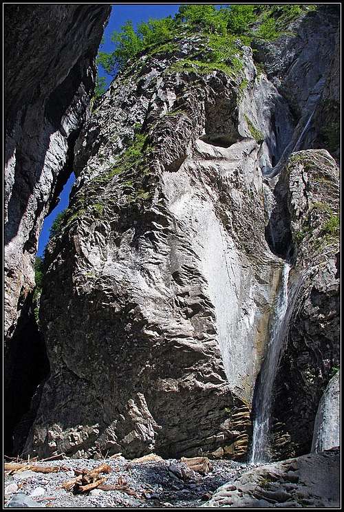
The side waterfall
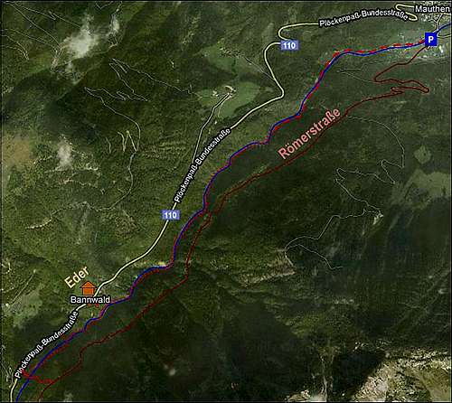
Ploecken Pass / Passo di Monte Croce Carnico is a high mountain pass which has been in use since ancient times. The Ancient Romans built a road over it, thus connecting Aquilea with their northern provinces. Still today remains of that road can be seen on the eastern side of the gorge ("Via Iulia-Augusta"). Today a modern road is running above the western bank of the canyon.
Otherwise Mauthner Klamm is a canyon between the summit of Gailtaler Polinik and Mooskofel. Its most picturesque part is below, where it has up to 200 meters high vertical walls, while above, below Ploecken Haus the gorge is not so deep.
The lower part of the canyon (1.5 km) is a simple hike, appropriate for everyone. The upper two thirds (2.6 km) are hard, appropriate only for experienced. Unfortunately those who return after the lower part can exit the canyon, but must go back by the same way along the Valentin Bach creek.
Klabautersteig was in the last few years closed due to landslides. But in 2010 it was completely cleaned and repaired and has been opened since July.
Getting There
See the parent pages how to get into Mauthen in the valley of Gail/Zilja.
Route Characteristics
Route type: Wading through a wonderful canyon, hard passages are detoured by ferrata sections.
Difficulty: Ferrata sections are rated C by the Austrian (A-E) rating system.
Starting place/altitude: Mauthen - Waldbad, 700 m.
End place/altitude: The road to Ploecken Pass, 1000 m.
Time needed: 2 h 30 min up and 1 h 30 min down (or 20 min with a bike).
Power: medium hard (ferrata sections require some pulling-up).
Psyche: medium hard.
Orientation: no problems.
Best season: Summer (July - September). Water is very cold. Water level must not be very high, otherwise the canyon is unpassable.
Best day time: Around noon when there is sun light in the canyon.
Getting there: See the parent page how to get into Koetchach-Mauthen. Waldbad is a nice recreation area, with a restaurant, few pools for children, etc. In Mauthen there's also a renowned World War I museum.
Logistic: Exiting above on the road, you will hardly catch a local bus back to Mauthen (check itineraries). Other options are bike, walk, hitch-hike,...
Gear:
- For ferrata climbing and scrambling over often slippery rock you need good shoes. But you will not come dry through the canyon. So, clogs are an option, but must have strong (Vibram) soles.
- For children and less experienced hikers a ferrata set can be useful.
- Poleas are useful for wading.
- Bike is highly recommended for a return.
Route Description
From Walbad parking place you go along the creek (inscriptions: Mauthner Klamm) till the interesting entry in the canyon. A picturesque natural wall is perforated, so you enter through a nice gate. Then a comfortable path is going along the creek, crossing it a few times. As the walls immediately become almost vertical, a few tunnels also help the path to come through the most difficult sections.
 The entry |
 Mauthner Klamm |
 Mauthner Klamm |
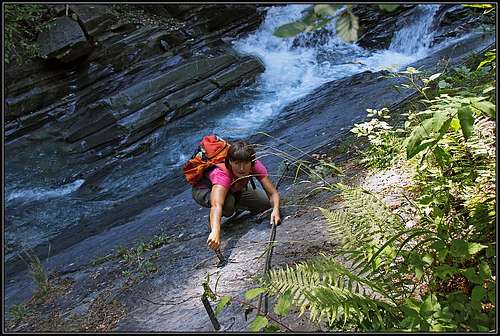
After 1.5 km the path disappears, we are on the right bank of the creek (looking downstream). On the other side (there's no bridge) the inscription says that Klabautersteig begins there. We see a few destroyed bridges, hanging on the walls, but marks will lead us by the water bed. So, take off your shoes, put on clogs or whatever you will use for wading. Behind the corner, the gorge becomes more and more picturesque. Distinct parts are named as for example: "First Darkness", "First Waterfall", "Sunny Beach", "Moss Shower" and "Klabauter Slab". There are altogether three or so darknesses and some six waterfalls on the main creek.
 Wading |
 Scenery |
The "Klabauter Slabs"
So, we mostly walk and scramble by the creek, obstacles are many, from fallen wood logs to big boulders and deeper ponds which we must detour. Allways the best passage is indicated with red marks or arrows.
Some places, especially waterfalls, are harder to overcome - on those places the route goes by the neighbouring walls and slabs, often exposed, but well enough protected. One or two sections climbing requires some strength in hands and if you are in clogs, also finding places to step on is not just easy. That's what the grade C of Austrian ferratas means.
Above a waterfall
In the canyon there are many places of incredible beauty. The first darkness is a closed place, where walls are high, due to geological structure rocks are of different colour and through that labirynth a crystal clear creek is flowing.
On other places rock formations are picturesque, dead wood logs look like funny creatures, from the side walls small waterfalls are pouring into the gorge.
There's one special place, where you just arrive through a narrow gorge, where behind the corner from the left a beautiful, strong waterfall is falling down. And, if you want due to cold water to make a rest, there are sunny places and nice ponds of clear, emerald water to enjoy.
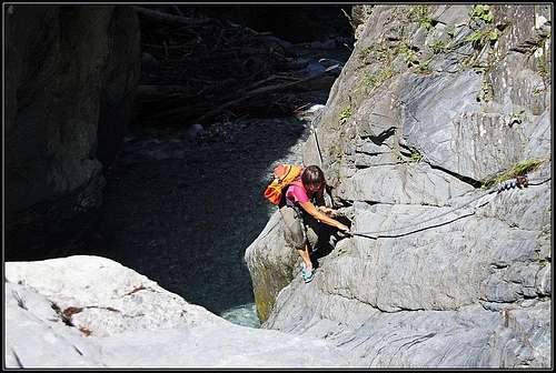
Climbing in clogs
In the upper part you already have a feeling that scenes are being repeated. There it's already time to start thinking of an exit.
The first emergency exit (to the west up) is not to be recommended. The slopes are still high, through a steep forrest the exit would bring you close to Eder hut. If you have bikes waiting you up there, they are probably some 750 meters further up the road, across the side creek which the main road overcomes with a big turn. So, we continue along the creek.
The second emergency exit would soon bring us on the main road (we see it already some 30 meters above), but it's still too early. We used it, but then we continued by the path which brought us into the gorge again. So, continue by the main creek, pass the "Moss Shower", do a few more ferrata sections and finally you will reach the clearing where you can exit either left or right. Towards the right (west) an almost cart-road goes and brings you soon up on the main road. Towards the left (east) you soon get on the marked trail - by that one you can continue returning down to Mauthen. Later it is the marked, easy Roemerstrasse, which will take you 1 h 30 min to return.
Of course it is most pleasant if on the main road bikes are waiting you. In 15 minutes you will be down in Mauthen.