Overview
![Gleckspitze / Collecchio]() Gleckspitze seen from Obere Weißbrunner Alm Gleckspitze seen from Obere Weißbrunner Alm |
, sometimes simply called
Gleck or
Collécchio in Italian is an near-3000er located close to the geographical centre of the
Ortler / Ortles Group. It is the westernmost summit of
Ultentalkamm / Cresta di Val d'Ultimo, the south-easternmost subgroup of the range. Rather than being a single crest like the names appears to indicate the subgroup is a complicated jumble of lesser mountains, located between
Ultental / Val d'Ultimo in the north and
Val di Sole with its side valleys in the south. It is the south-western endpoint of a ridge which separates
Kirchbergtal / Valle Monte Chiesa and
Weißbrunner Tal / Val di Fontana Bianca. It also is located on the language border between the German speaking
Südtirol / Alto Adige and the Italian speaking
Trentino.
Even though the two ascent routes from Rabbi in the south are shorter in terms of length, and even though there are two Refugios at either side of the mountain,
Rifugio Lago Corvo / Haselgrubhütte to the east and
Rifugio Silvio Dorigoni in the west, the mountain is almost exclusively climbed from the north. Thanks to the lower elevation difference - the northern trailhead at
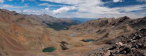
Weißbrunner See / Lago Fontana Bianca is located at 1900m - the long hike through
Weißbrunner Tal / Val di Fontana Bianca is rather popular. Though most hikers avoid the final ascent to
Gleckspitze / Collécchio they enjoy to visit the many mountain lakes of the valley, remainders of the glacier grind during the last ice age.
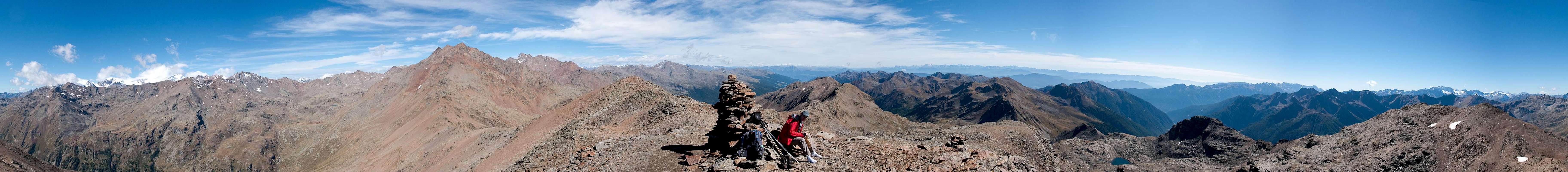
Gleckspitze / Collécchio has two summits of nearly identical height. The northern summit, on which the cross is located is some 2m lower than the southern one. Thanks to their position above the junctions of three valleys, summit views are good, though not perfect.
Gleckspitze / Collécchio is located very close to Hintere
Eggenspitze / Cima Sternai and
Zuftrittspitze / Gioveretto, which block the views to the north-west.
Monte Vioz,
Palon de la Mare and
Cevedale can only be seen across the
Moosferner / Vedretta di Careser Cirque so that only 180° of the whole panorama are open.
360° Summit Panorama
360° summit panorama Gleckspitze / Collecchio |
Getting There
![The Lakes of Weißbrunner Tal]() The Lakes of Weißbrunner Tal
The Lakes of Weißbrunner Tal
There are two trailheads for the three hiking routes to
Gleckspitze / Collecchio, one in the north at the very end of
Ultental / Val d'Ultiomo at
Weißbrunnsee / Lago Fontana Bianca, the other in the south at
Rabbi. The main access road will be from Brenner Motorway (though Rabbi can also be reached via Passo Tonale from Lombardia).
- Ultental / Val d'Ultimo
- Take Brenner Motorway A22 to the exit Bozen Süd / Bolzano Sud
- Switch to SS38 towards Meran / Merano.
- Take the exit Lana and drive through the town, following signs to Ultental / Val d'Ultimo
- Drive through the Valley to its very end at St. Gertraud / Santa Gertrude
- Here turn on a narrow mountain road which leads to Weißbrunner See / Lago Fontana Bianca
- Rabbi
- Take Brenner Motorway A22 to the exit San Michele all'Adige
- Turn onto SS43 north-west until you reach Terzolas and Malè
- Switch to SP86 to Rabbi
Red Tape
Looking across upper Valle di Rabbi towards the southern Ortler Group |
Gleckkspitze belongs to the
Nationalpark Stilfser Joch / Parco Nazionale dello Stelvio where the usual restrictions apply. The area around
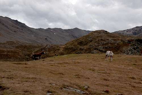
Langsee / Lago Lungo is used as a pasture for goats, sheep and horses which roam free in the whole area but are used to the visits by hikers. Fishing in the lakes is restricted.
Accommodation
Weather Conditions
Maps & Books
Maps
- Digital Maps
- Regular Maps
- Ortler / Ortles - Cevedale
Kompass Map WK 72
1:50.000
ISBN: 3-85491-081-9
Books
- Meran, Burggrafenamt, Ultental, Passeiertal
Kompass Guidebook WF951
Franziska Baumann
Kompass Verlag
ISBN: 978-3854913863
- Rund um Meran - Passeiertal, Texelgruppe, Ultental
Henriette Klier
Rother Verlag
ISBN: 978-3763342907

 4634 Hits
 84.27% Score
 18 Votes
 Gleckspitze seen from Obere Weißbrunner Alm


 The Lakes of Weißbrunner Tal