Starting out...ambitions high
Our plan was to get dropped off at Piney Lake on the west side of the gores and traverse over a few mountain passes; attempt Eagles Nest, Powell, Peak G, West Partner Peak and Peak Q and head out the Slate Creek trail and get picked up on the other side of the range at Highway 9. It didn't work that way.
The beginning of the trip started out well. We started hiking the Piney River trail after we were dropped off at 11:00 pm Friday September 2nd. We made it easily to our camp spot by midnight and set up camp near the shore of Piney river. The plan for Saturday would be to day hike up over Game Pass and climb Eagles Nest, then head back and over Kneecnocker and hit Powell before heading back down to the tent and moving to Upper Piney Lake for the night.
Once again...it did NOT work that way. Looking back on that plan I feel stupid.
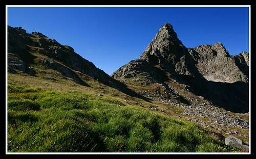
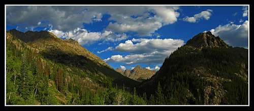
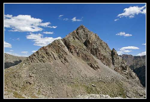
Saturday morning started out nice as we woke up early and got to the lush valley below Kneeknocker Pass before sunrise. Took a small break and finished the climb up to Game pass. To get to this pass, head northwest from the lush valley rather than northeast for Kneeknocker. Just as we started descending into the upper reaches of the Cataract drainage I got this photo looking back at Game Pass.
![Game Pass and Corner Peak]() View looking Back to Game Pass
View looking Back to Game Pass
The plan from there was to descend slightly, drop the packs and climb Eagles Nest following the south ridge route described by Scott in this page:
Eagles Nest
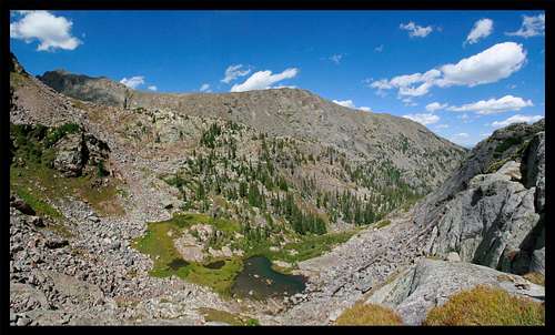
Just as we dropped the packs I took this nice photo
![Upper Cataract Basin]() It's still green in the Upper Cataract basin...impressive for September in Colorado
It's still green in the Upper Cataract basin...impressive for September in ColoradoEagles Nest
We started climbing up the steep talus slopes with GPS and camera in hand. Finding the right gully that would take us to the 12,700 foot saddle between Eagles Nest and Powell was a challenge. After trial and error, the third gully we tried was the one and we got to the col. I was surprised to have already done a difficult class 3 move just getting there. I had no idea the true difficulty of the ridge traverse to come.
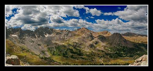
Anyway, I shot a nice panorama of the view to the west from the saddle.
![The Heart of the Gores]() View west from Eagles Nest-Powell Saddle
View west from Eagles Nest-Powell Saddle
We started climbing northward on the ridge and I quickly started shaking. I was already uncomfortable with the exposure. walking up very steep slopes is one thing but narrow ridgecrest exposure is another. I actually enjoy climbing up rock slopes at 45 degrees or greater but I can't handle exposure.
My roommate started going up himself and I told him I'd wait.
Shortly after (maybe 10 minutes) he returns because of the commitment that the ridge required. Some cumulus clouds were forming (crap! the weather forecast said 0% chance...it lies!!!) and neither of us wanted to be up there if lightning was going to strike. So we headed back down the slope to the packs however about halfway down, my trusty pair of Columbia hiking shoes that I've used for 6 years decide to fail. The sole was ripping off on the right foot. They had finally had enough after an estimated 1500 miles of hiking I'd put on them.
So what? It was dry and there wasn't any snow around. I couldn't keep the rocks out and I would risk losing the sole completely if we went over Kneeknocker and up Powell.
Knowing we had to get back to the valley below Kneeknocker we rushed back down there where there was a chance of seeing people. That chance however is still small in the Gores even on a nice Labor day weekend (hence why I love the Gores...so remote!)
A couple more photos on the way back...
![Peak C]() Peak C from just below Game Pass
Peak C from just below Game Pass![Peak C]() Peak C from the lush valley
Peak C from the lush valley
What luck!
We found a group that had just finished Powell and a group about to go over Kneeknocker with their pet goats. They seemed pretty impressed when we told them where we went.
One of them had a small bottle of superglue that worked great on holding my sole on throughout the trip. Unfortunately we found out that our custom route we had planned from Upper Piney Lake to the Slate Creek drainage was not going to work. They told us about cliffs and impossibilities a simple backpacker would not be able to do.
Fail 1: South ridge of Eagles Nest was way too hard and committing for what we had planned.
Fail 2: My shoe broke!
Decisions...Decisions
So we sat there in the valley below Kneeknocker for about an hour deciding what we should do. We finished fixing my shoe and he gave me a Gores map as he overheard our problem with trying to find a new route. We also talked to the group with the goats and enjoyed that. After awhile they started over Kneeknocker Pass (we also figured out why it's called Kneeknocker...the goats actually walk on their knees as we saw first hand).
Here is the fundamental issue we had:
No matter which reroute we planned we HAD to get to Colorado highway 9 somehow. Our original plan was to take us to the Slate Creek trailhead where our ride would be waiting Sunday evening. We figured if we still get to highway 9 we can call our ride to drive up a little further to get us...no big deal right? WRONG!
A series of terrible events led to ultimate fail.
We finally came to the decision to go back down to the Piney River trail, get the rest of our gear and tents and camp at the valley below Kneeknocker Pass. Sunday the 5th we would head over Kneeknocker, bagging Powell on the way and head down the Black Creek drainage and get to Highway 9 by 7pm. The map the guy who fixed my show game us said there was a nice trail from Duck Lake down the Black Creek drainage to Black Lake where there was a road.
That map no longer exists...I destroyed it!
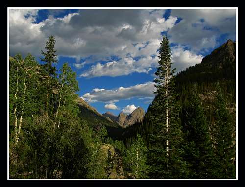
So we retrieved the tents and gear and climbed back to the valley with good lighting. Got lucky with these photos of The Spider way in the distance beyond Upper Piney Lake.
![The Spider]() The Spider from the Trail to Kneeknocker Pass
The Spider from the Trail to Kneeknocker Pass![The Spider]() The Spider from the Trail to Kneeknocker Pass
The Spider from the Trail to Kneeknocker Pass
We set up camp in the grass and went to sleep to mountain goats roaming around our tent.
Fail 3: We thought you could easily hike down the Black Creek drainage
Fail 4: We didn't realize there was private property around Black Lake
Sunday Morning and Mt. Powell
So we got up pretty early and quickly started climbing up Kneeknocker Pass. On our way up I saw someone coming down. Down you say? Yes, someone had woke up very early to get some sunrise photos of Ripsaw ridge from Kneeckocker. I was jealous. I really like photography and had my SLR the whole trip, but didn't wake up that early.
This person happened to be the famous Summitpost member Kane. Amazing; all those Summitpost pages of his I read, many of them in the Gores. We talked awhile about peaks climbed, photography and general traveling before we went opposite ways (probably should have followed him back to Piney Lake!!!)
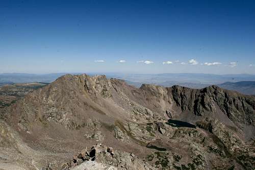
We dropped the packs once again at the base of Mt. Powell and climbed the simple south slope to the top in an hour and a half.
![Eagles Nest from Powell]() Eagles Nest seen from Mt. Powell
Eagles Nest seen from Mt. Powell
Quickly descended knowing we had a long way to go.
Success 1: Mt. Powell
WOW! Our only success
We started descending east towards Black Creek and stopped to take a break as we saw the same group with the goats camped just below Bubble Lake. That was their destination for the day and they just got back to camp.
Duck Lake
We talked some more and found out they were on a three night backpack for Labor Day weekend and they were camping there that night again (Sunday night).
I remember complaining how we didn't get Labor Day off of school and said we had to get to highway 9 by 7pm.
Wouldn't you know it one member of that group had actually descended Black Creek before and told us numerous times we'd be better off going back to Piney Lake.
Being young we just brushed it off. Besides, we HAD to get to highway 9 or our ride would flip out.
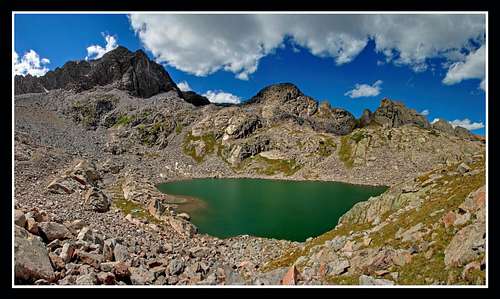
So we pressed on and climbed for our last time up to an unnamed pass at the western end of Dwarf Pyramid and was greeted with one of the few glacial fed lakes remaining in Colorado...Duck Lake
![Duck Lake]() Duck Lake seen from unnamed pass near Dwarf Pyramid
Duck Lake seen from unnamed pass near Dwarf Pyramid![Mt. Powell from Duck Lake]() Mt. Powell Backdropping Duck Lake
Mt. Powell Backdropping Duck Lake![Dwarf Pyramid]() Dwarf Pyramid from unnamed pass
Dwarf Pyramid from unnamed pass
We started looking for the trail as we descended to Duck Lake but couldn't find it. I guessed it may have started a little lower. We took a quick break at the east end of Duck Lake and by the time we camp to a series of cliffs, we knew there wasn't a trail and thats when I realized we were screwed.
Here's a shot of some tarns 500 feet down a series of cliffs (I still felt the need to take nice photos...that's the one thing I do NOT regret doing about that trip)
![Upper Black Creek Drainage]() Tarns in the Remote Upper Black Creek Drainage
Tarns in the Remote Upper Black Creek Drainage
Fail 5: No trail...that map lied!
Fail 6: We now had to negotiate cliffs!
The descent from Hell
We managed to find one way down the cliff bands (luckily) and continued descending following the creek. At first it wasn't bad at all and we were moving down pretty quick. However as we got lower, the trees got thicker and we got slower. By now it was 3pm. We had 4 hours to get to highway 9 and 4 miles of bushwhacking to do as well as a 4 mile road to walk (not to mention hoping the owners of the land would feel some grief for us)
We stayed mentally strong and didn't flip out even though the bushwhacking was awful and we were moving around .5 miles per hour getting scratched up to hell and trying to avoid the creeks and cliffs.
Even saw a wild elk.
The one thing that really amazed me though was the lack of game trails. We were truly bushwhacking. Another problem was the huge mass of down trees everywhere described perfectly by my friend as "walking on pick-up-sticks"
You lose your footing...you sink into an endless pit of demise!
Heres a photo I shot to show what we had to go through for 4 miles.
![Horrible Bushwhacking]() Bushwhacking the Black Creek Drainage
Bushwhacking the Black Creek Drainage
Darkness was slowly setting in. 7pm had long past but the fact that I told our ride to wait until 10pm before worrying and leaving for help kept me pushing hard. I was so focused on getting out that I didn't eat or drink anything since the summit of Powell hours earlier.
We finally got to Black Lake a half hour before dark. We made it right? There was a house on the other side of the lake. We could ask for a phone to call our ride right?
Fail 7: Didn't eat or drink
Fail 8: Grossly underestimated the size of Black Lake
Fail 9: Lost all mental strength
Our bivy and missed day of school (Labor Day)
I blew up. When I noticed how long it was going to take to bushwhack around the lake I gave up. That sudden loss of mental strength prohibited me from moving at all. I sat down and stayed there. If we got there 15 minutes earlier we may have made it but by now it was dark and we were on a rocky slope near the shore of the lake.
We couldn't put up a tent so we laid the sleeping bags out and tried to go to sleep. We left the rain fly of the tent accessible in case it rained.
Sure enough there was a small thunderstorm and about 1 minute of rain. Wasn't bad but it woke me up.
We woke up and quickly packed and finished the bushwhack around the lake.
We got to the road and finished the walk to highway 9.
My cell phone got service for a few minutes and on it was a message from the Summit County SAR, and about 10 people I know.
For gods sake we were delayed 1 night and everyone flips!
I was lucky enough to be in a spot with decent service and I called the search off and notified a few people we were ok.
Our ride was long gone but we were able to hitch a ride to Silverthorne and call another friend to pick us up. I didn't hear the end of our excessive fails for a long time.
Fail 10: We thought we would be able to tackle a LONG cross country backpack through the Gores
Success 2: We have a new respect for the Gores
I came to the conclusion that none of this would have happened if our flippin school gave its students Labor day off!! :)


Comments
Post a Comment