

-
 63960 Hits
-
 95% Score
-
 50 Votes
|
|
Area/Range |
|---|---|
|
|
37.43510°N / 118.747°W |
|
|
Hiking, Mountaineering, Trad Climbing, Mixed, Scrambling, Skiing |
|
|
Spring, Summer, Fall, Winter |
|
|
10230 ft / 3118 m |
|
|
Overview
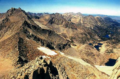
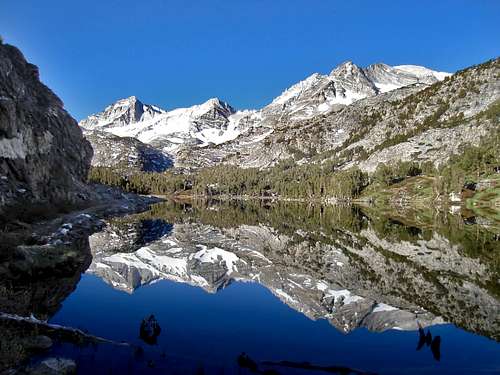 Sierra crest from Long lake
 When driving up the Rock Creek Road from Tom's Place one begins to get a direct taste of the grandeur of this marvelous area of the Eastern Sierra. First, the massive Mount Morgan South at 13,748' looms ahead. A few miles further along there is Bear Creek Spire, Mount Dade and Mount Abbot, all high thirteeners that come into view beyond Rock Creek Lake. A couple more miles bring you to the Mosquito Flat trailhead parking. A short hike of less than a mile and you're in the heart of Little Lakes Valley surrounded by some of the most beautiful scenery the high Sierra has to offer. With a starting elevation of 10,230' at the parking area, and an excellent trail system, one has easy access to a great cirque of peaks and two major passes into the backcountry that can all be done in a day.
The valley is packed with sparkling trailside lakes and streams with lofty granite giants on all sides.
This is truly a mountain lovers paradise for hiking, fly fishing, camping and climbing. With all this being the case the area is a very popular destination in the summer. Everything from short 1-2 hour strolls up to Marsh or Heart Lake to extensive climbing/backpacking adventures along the crest or over the passes await.
Depending on the snow-fall during the year, hiking season may begin as early as Memorial Day Weekend or after July 4th. Typically, the best times to visit are July, August, and September. The area itself rarely has fires, but smoke from wildfires may impact visibility during August and September.
Appreciation is owed to Windsor Riley (aka Noondueler) who created this page, and who passed away in 2016.
Getting There
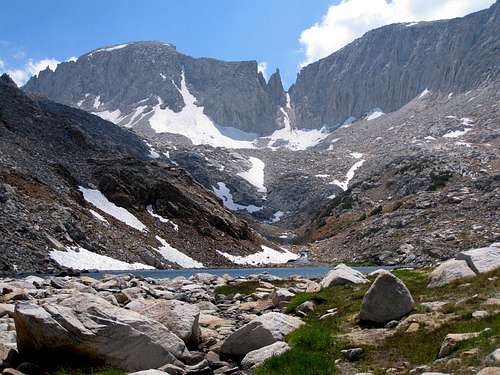
 Chickenfoot Lake north panorama
From the junction of Hwy. 120 and Hwy. 395 at Lee Vining go south 41 miles to Tom's Place. From Hwy. 203 and 395 at Mammoth Lakes go south 14.5 miles to Tom's Place. From Bishop go north on 395 from the junction with Hwy. 6 at the north end of town 23.5 miles to Tom's Place. At Tom's Place turn southwest into the range on the Rock Creek Road and go 10.5 miles to Mosquito Flat where the road ends. This parking lot can fill up in the summer, especially on weekends so you may want to get there early.
Red Tape
 Little Lakes Peak, Morgan Pass and Rosy Finch Peak
Little Lakes Valley is in the John Muir Wilderness. There are no permits required for dayhiking. The Mono Pass and Morgan Pass Trails are quota trails. Wood campfires are prohibited in Little Lakes Valley and bears roam the area. Mosquito Flat didn't get it's name for nothing. Be prepared for a potential onslaught of pesky skeeters in the early summer of Little Lakes Valley especially around trees, lakes and streams. Pack some deet. For camping in the John Muir Wilderness, permits can be obtained at: Mammoth Ranger Station and Visitor Center, 760-924-5500. Box 148 Mammoth Lakes, Ca. 93546 or the White Mountain Ranger Station, 760-873-2500. 798 north Main St., Bishop, Ca., 93514
Activities
 Approaching Mono Pass
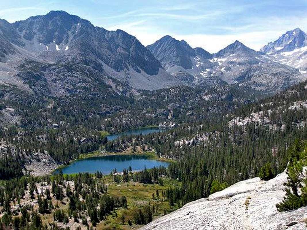 Little Lakes Valley looking south from Mono Pass Trail
Camping
 Mt. Morgan and Little Lakes Peak from the Mono Pass Trail
These campgrounds are all in succession further up the Rock Creek Road. Lower Rock Creek: 7,300', 0.3 miles on the Rock Creek Road from Tom's Place the right 0.2 miles. Aspen, 8,300', at 3.7 miles. Iris Meadow: 8,400' at 4 miles. Big Meadow: 8,500' at 4.5 miles. Palisade: 8,900' at 5.8 miles East Fork: 8,970' at 5.9 miles then go left 0.7 miles. Pine Grove: 9,300' at 7.4 miles. There are several campgrounds around Rock Creek Lake, 9,700' at 8.6 miles. Mosquito Flat: 10,200' at 10.5 miles.
Rock Climbing Stepping up the technical level, on the west side of the canyon you will find Iris Slab, an 80’ low angle, east-facing rock and a great place for easy trad routes and top-roping.
Winter Activities During winter, the U.S. Forest Service’s East Fork Sno-Park area, located about 6 miles up Rock Creek Road from Tom’s Place, can be enjoyed. There is a $5 per day fee to use this area. In this area, you can find yourself a nice spot for a camp and conduct winter activities from your camp, be it snowshoeing, skiing or climbing. If cross-country skiing on groomed trails entices you, several mainly flat terrain routes start at the Sno-Park. One of the routes is to Mosquito Flats trailhead and then on towards Bear Creek Spire. At dinner time, snowshoe or ski up Rock Creek Road to the Rock Creek Lodge where you can enjoy some hearty fare at the lodge’s eating facility.
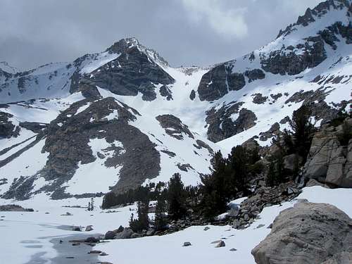
 Practicing snow skills near East Fork Sno-Park, 3.09.
 Snow dog Mr. Wriggles near East Fork Sno-Park
Although there are other places in the Rock Creek Canyon area worthy of visiting (for example, the Hilton Lakes area and Tamarack Trailhead located at Rock Creek Lake), the focus here is on Little Lakes Basin and its environs.
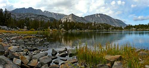
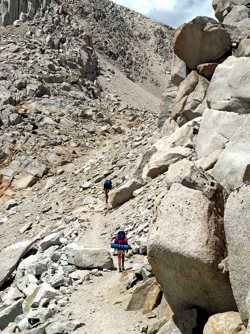
Hiking Little Lakes Valley is a basin where numerous high-elevation lakes are linked by excellent hiking trails and ringed by 13,000 foot + peaks. It is alpine beauty personified. FURTHERMORE, IT IS ALMOST A SIN WHAT BEAUTY IS ACCESSIBLE WITH VERY MINIMAL EFFORT ALONG LITTLE LAKES VALLEY TRAIL. There is no better place for introductory hiking than the Little Lakes Valley Trail. Within 30 minutes of easy hiking, and with minimal elevation gain (remember you start from over 10,000’) you can reach the first of several alpine lakes of stunning beauty; among others, Mack, Marsh, Heart, Hidden Lakes and Long Lake. Because most of these lakes provide excellent campsite areas, they are ideal for beginning backpackers and for family backpack outings with small children.
 One of lakes along Little Lakes Valley Trail
 Lake along Little Lakes Valley Trail
Cross-Country Runners One strenuous activity you might not normally associate with Little Lakes Valley is cross-country training. But during August, the Mosquito Flats Trailhead becomes a popular spot for high school cross-country coaches to unleash their charges on the mountain to do their summer training.
Fishing Fishing is a popular activity along the string of lakes in this basin with small brook trout being the most prevalent catch. There are also 3-5 pound browns to be caught and some lakes have wild rainbow trout as well.
 Looking for a bite at a lake along the LLV Trail
  Along Mono Pass Trail, 8.09
Horse/Mule pack outings
If you don’t want to carry a pack, the Rock Creek Pack Station can set you up with a pack outing so can travel in the saddle and let mules do the heavy work.
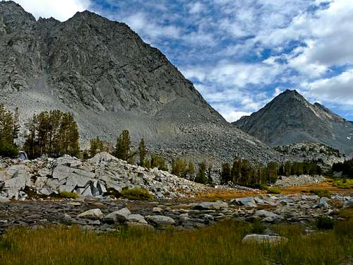
Trails out of Mosquito Flat
 Peaks surrounding Little Lakes Valley from Mono Pass Peak
 Mono Pass Trail: From Mosquito Flat take the main trail south 0.5 miles to the junction to Morgan Pass (10,440') and take the Mono Pass Trail to the right. Continue on the Mono Pass Trail as it climbs up to the right then turns right and climbs up to the pass at 3 miles (12,040'). This leads down into Pioneer Basin. Morgan Pass Trail: Take the main trail 0.5 miles to the junction with the Mono Pass Trail (10,440') and stay to the left continuing up the valley 3.5 miles to Morgan Pass at (11,080'). This leads to the Pine Creek area. Ruby Lake: Take the Mono Pass Trail 1.3 miles from the Morgan Pass junction and go left at a flat 0.3 miles to Ruby Lake (11,140') Mack Lake: To the left of the main trail at Mosquito Flat take the trail to Mack Lake 0.5 miles to the lake (10,377'). West canyon trail: From the junction with the Mono Pass trail at 0.5 miles a trail goes north along the west side of the canyon 2 miles to Rock Creek Lake. FROM ROCK CREEK LAKE: Francis Lake: From the east side of Rock Creek Lake take the trail up and around to the right 2.5 miles to Francis Lake in the small valley northeast of Mt. Morgan at (10,900').
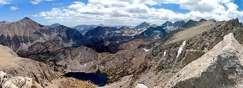
Peaks of the Little Lakes Valley Area.
 Sierra Crest from Bear Creek Spire with Little Lakes Valley below right
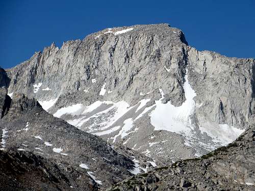
A list of the peaks running clockwise from Rock Creek Lake around Little Lakes Valley to Mono Pass. Mount Morgan (S), 13,748'- accessed via the Francis Lake Trail. All of these peaks are initially accessed via these main trails then off trail scrambling. The Morgan Pass Trail Little Lakes Peak, 12,782' Rosy Finch Peak, 12,744' Pyramid Peak, 12,840' Bear Creek Spire, 13,720' Pipsqueak Spire, 13,268' Mount Dade, 13,600' The Mono Pass Trail via Ruby Lake Trail. Mount Abbot, 13,704' Mount Mills, 13,451' Ruby Peak, 13,188' Treasure Peak, 12,920' The Mono Pass Trail. Ruby Mesa, 13,125' Mono Pass Peak, 12,760'+ Mount Starr,12,835' Lookout Peak, 11,902'
Recommended Hike: Ruby Lakes
 Mt.Abbott (L) and Petit Grifon (C) Mt. Mills (R) from drainage above Ruby Lake
A highly recommended day hike from the Mosquito Flats Trailhead is to Ruby Lake. Along the Little Lakes Valley Trail, the turn-off for Ruby Lake is about ½ mile from the trailhead. On the ascent, you will get incredible views of Little Lakes Valley below. Just below the lake, you encounter marvelous cascades from the drainage above. Ruby Lake is an eye-catching, relatively secluded alpine lake at 11,140’elevation and a great spot for lunch.
 Mt. Starr, (12,835') and Ruby Lake (11,140')
From here, one option would be to continue up the trail towards Mono Pass (elev. 12,045’). The Mono Pass Trail continues west over the Sierra Crest and drops into the Mono Creek Recesses and Pioneer Basin (the latter a popular pack station trip destination). A more adventurous alternative is to head SW cross-country up the terrain above Ruby Lake toward the snowfields below Mt. Abbot. In your line of sight, adjoining Mt. Abbot, will be the beautiful pinnacle known as Petit Grifon (it features a 5.7 alpine route to its tiny summit). You will be scrambling up the drainage alongside the snow melt coming down under the rocks, alternating with level areas where small lakes have formed. It will feel like real adventure in a pristine alpine setting.
Recommended Campsites: Gem Lakes and Treasure Lakes
 Pyramid Peak (12,840') seen from LLV side
If you want to find excellent outlying campsites, pack all the way along Little Lakes Valley Trail to Gem Lakes and you will have an abundance of possible campsites amongst the lakes there. Campsites along Gem Lakes are only about an hour and a half hike from the trailhead with only 700’ of gain. As you hike, be on the look out for a spot where the trees frame a gap with Bear Creek Spire at dead center. It’s a photo op not to be missed. From your campsite at Gem Lakes, you can plan day hikes of Bear Creek Spire, Mt. Dade or Pyramid Peak, to name just a few. In the winter, you can reach Treasure Lakes with a little cross-country jaunt off the Little Lakes Valley Trail and use the area as a base camp to do a classic snow climb like Mt. Dade’s Hourglass Couloir.
 Mt. Dade's Hourglass Couloir seen from Treasure Lakes, Jun 09
If you wish, you can continue past the Gem Lakes turn-off and continue up toward Morgan Pass (11,155’). Over this pass, you will drop SE along Morgan Creek to Upper Morgan Lake and Lower Morgan Lake.
Current Weather and 5-Day Forecast; Map
 Mt. Dade and Mt. Abbot from the Rock Creek Road
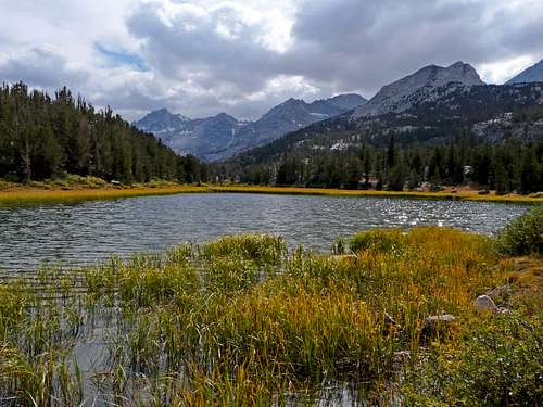 Marsh Lake
For the current weather forecast for nearby Tom's Place click here. The Harrison Map for this area is Mono Divide High Country Trail Map. Have fun and be safe.
 Long Lake, Jun 09