
-
 21308 Hits
-
 85.36% Score
-
 20 Votes
|
|
Mountain/Rock |
|---|---|
|
|
37.42358°N / 118.77834°W |
|
|
Inyo |
|
|
Hiking |
|
|
Summer |
|
|
12780 ft / 3895 m |
|
|
Overview
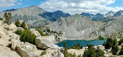 Mt. Morgan, left and Ruby Lake from Mono Pass Trail, Lookout Peak is above the lake
This is a fairly stable sand climb with class 2 summit rocks. The views north over the Mono Recesses and Pioneer Basin are outstanding as well as the high Sierra surrounding Little Lakes Valley.
Getting There
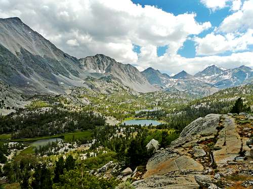 Little Lakes Valley from Mono Pass Trail
Red Tape
 Pioneer Basin from "Mono Pass Peak"
For camping permits in the John Muir Wilderness contact:
Mammoth Ranger Station and Visitor Center. 760-924-5500. Box 148 Mammoth Lakes, Ca. 93546
White Mountain Ranger Station. 760-873-2500. 798 north Main St., Bishop, Ca. 93514
Camping
 South from "Mono Pass Peak"
ROCK CREEK campground, 7,300' .3 miles on the Rock Creek Road from Tom's Place then right .2 miles.
ASPEN, 8,300' at 3.7 miles
IRIS MEADOW, 8,400' at 4 miles
BIG MEADOW, 8,500' at 4.5 miles
PALISADE, 8,900' at 5.8 miles
EAST FORK, 8,970' AT 7.4 miles
There are several campgrounds around Rock Creek Lake, 9,700' at 8.5 miles
Mesquito Flat at 10,100' at roads end 10.5 miles