
-
 9045 Hits
-
 84.27% Score
-
 18 Votes
|
|
Mountain/Rock |
|---|---|
|
|
46.54865°N / 7.01700°E |
|
|
Hiking, Via Ferrata |
|
|
Summer, Fall, Winter |
|
|
6568 ft / 2002 m |
|
|
Overview
 Le Moléson seen from the Hôtel Réfuge de Plan-Francey Le Moléson seen from the Hôtel Réfuge de Plan-Francey |
North of the central Alps main ridge, in the Swiss Canton de Fribourg, you find the region of Gruyère, rather more famous for its cheese than for its mountains. Mostly the region is flat (considering that this is Switzerland) with many large lakes and wide pastures. In its midst, however, there are some half dozen mountains, all in the 2000m range, which from a grouping perspective belong to the Fribourg Prealps. One of these, 2002m high, stands above Lac de Gruyère like a sentinel. Its name: Le Moléson.
Le Moléson is made up from main dolomite rock but mostly covered with grass. Its steep slopes make it resemble some of the famous Allgäu Alps steep grass mountains like Höfats or Schneck. Like these it has several summits (three), which are connected by a knife-edge ridge. The whole ridge has been protected, either by steel cables or (in its western part) by railings.
 |  |  |
Solitary standing Le Moléson is one of the premier lookout mountains in the Swiss Prealps, which in return is the reason why it has been over-developed. Apart from the three hiking routes (south slopes, north-west couloir) there is a two stage cable-car to a shoulder on the south ridge ensuring you will meet crowds on the top at almost all times of the day. Moreover, in 2004 it was decided to equip the north face of Petit Moléson, the northernmost summit, with a via ferrata, Voie Hohl. More recently, a second ferrata has been created, Voie du Pilier.
 |  |  |
Both ferratas are long, between 1100m and 1300m length, and climb the 400m north face on either of its sides. They are very exposed, sometimes overhanging, and require a lot of strength. On the other hand they are severely over-equipped with steel footrests and handholds so that the technical difficulty is largely reduced. If you stretch yourself you won't have to touch rock to reach the top. Thanks to a long ledge traverse almost on top of the route Voie du Pilier is considered easier but make no mistake, it is very demanding as well. It is estimated that 5 tons (!!) of steel went into the protection of Voie Hohl and you can easily see that Voie du Pilier will come up with a similar amount.
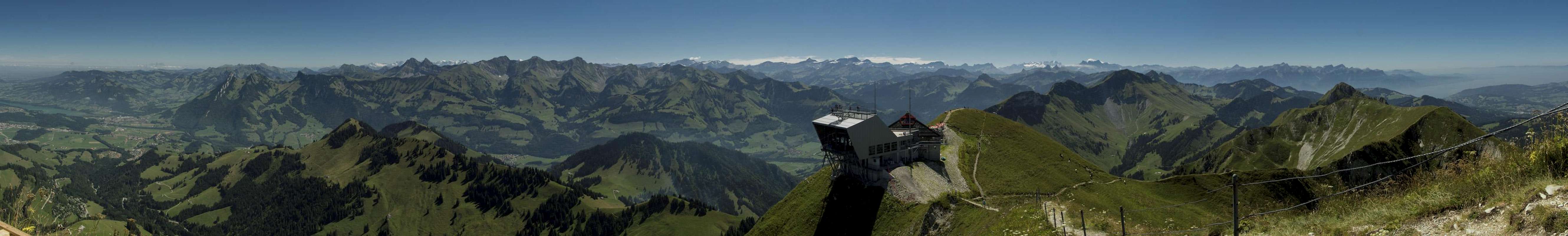
Summit Panorama
  |
Getting There
 Looking towards Mont Blanc from Le Moléson
- Take motorway A12 to the exit Bulle.
- Take B189 the road which circles Bulle to the towns south-eastern end, wher you turn onto B190.
- At Epagny turn right and drive through Prigny to Moléson sur Guyère (follow the signs to Moléson.
- Park your car in the large cable-car parking lot and take either the cable-car or hike to Plan-Francey, where hiking routes and via ferratas start
Red Tape
 Alpensalamander at the base of Le Moléson
Naturally you have to pay fees for the cable-car. Fees can be found here. Also, there is a fee of 4€ (adult, 2€ child) for the via ferratas though I must confess that I'm not aware anyone paid during our visit. I might be wrong.
Accommodation
There is a Hotel - Refuge at Plan-Francey, close to the cable-car central station. From accommodation perspective it is rather a mountain hut though they offer good and ample food. Make sure to get one of their cheese fondues at night.Gruyère accommodation
Weather Conditions
 Heavy Weather around Le Moléson
Maps & Books
Maps
- Digital Maps
- Regular Maps
- Rochers de Naye
Landeskarte 262 T
Schweizer Bundesamt für Landestopografie
1:50.000
ISBN: 978-3-302-00262-0
- Rochers de Naye
Books
- Klettersteigführer Westalpen
E. E. Hüsler
Bruckmann Verlag
ISBN: 3-7654-4212-7
- Klettersteige Schweiz
Iris Kürschner
Rother Verlag
ISBN: 978-3-7633-4305-8