Overview
Golden Wall Trail starts on Route 12 in Red Canyon and goes 700 vertical feet up the red hills to a 7860 ft saddle where it descends into another drainage and then continues to descend and eventually ends at the junction with Buckhorn Trail. At the junction you can either turn left and go up a hill to Buckhorn Point or turn right and descend to Red Canyon at Red Canyon Campground. You can then hike a short distance on the paved bike trail parallel to Route 12 to return to your starting point.
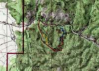
![Map]() Map
Map |
Getting There
From the intersection of Routes 12 and 89 (6 miles to the southeast of Panguitch, UT) drive a little more than 3 miles east on Route 12 and look for the sign for Golden Wall Trailhead on the south side of the road (Just to the west of the Red Canyon Visitor Center).
Route Description
| Place | Elevation | Distance |
| Golden Wall Trailhead | 7150 ft | zero |
| Saddle | 7860 ft | 1.30 miles |
| Low Point | 7640 ft | - |
| High Point | 7800 ft | - |
| Buckhorn Trail Jct. | 7640 ft | 1.30 miles |
| Buckhorn Point | 7800 ft | 0.20 miles |
| Campground | 7280 ft | 0.85 miles |
| Back to Golden Wall Trailhead | 7150 ft | 0.90 miles |
| Total | - | 4.55 miles |
At the trailhead you will see this impressive tower on the north side of Route 12.
The trail goes up near and sometimes into a dry streambed.
You can look back to see the 7889 ft Black Mountain.
![Black Mountain]() Black Mountain
Black Mountain |
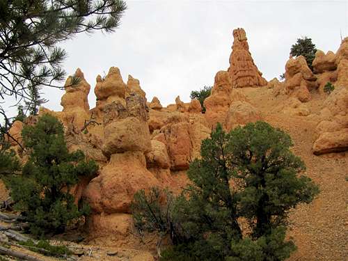
Red colored hoodoos and walls will be visible all around.
The trail makes a series of switchbacks and reaches the 7860 ft saddle. You will have good views of Black Mountain and Sevier River Valley.
![Sevier River Valley from the 7860 ft saddle]() Sevier River Valley
Sevier River Valley |
![Black Mountain from the 7860 ft saddle]() Black Mountain
Black Mountain |
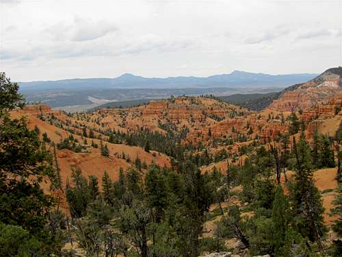
The trail descends into a valley and goes down to a 7640 ft low point and then back up again to 7800 ft giving you spectacular views of the red rock country.
![Black Mountain]() Black Mountain
Black Mountain |
![How Much Longer?]() How much longer?
How much longer? |
![Route 12]() Route 12
Route 12 |
You will then reach the end of the Golden Wall Trail at the junction with Buckhorn Trail. You can turn left and go 160 vertical feet up the steep trail to the top of a narrow ledge at Buckhorn Point where the trail ends.
![Trail to Buckhorn Point]() Trail to Buckhorn Point
Trail to Buckhorn Point |
You will then return back to the junction and continue to descend down a series of switchbacks toward Route 12. Buckhorn Trail will end at Red Canyon Campground.
![Route 12, Black Mountain & Red Canyon]() Rout 12 & Black Mountain
Rout 12 & Black Mountain |
Hike out of the campground. Just before Route 12 you will see a paved bike trail. Turn left (west) onto this trail and hike it 0.9 miles back to Golden Wall Trailhead.
![Bike Trail parallel to Route 12]() On Bike Trail
On Bike Trail |
Red Tape
No Fees or permits needed for day hikes.
For all rules and regulations contact:
Powell Ranger District-Dixie National Forest
Panguitch, UT
Weather
See the forecast for the nearby Bryce Canyon National Park:
Forecast.