
-
 9719 Hits
-
 83.42% Score
-
 17 Votes
|
|
Canyon |
|---|---|
|
|
44.47258°N / 103.84844°W |
|
|
Overview
Spearfish Canyon
Usually when people think of the Black Hills, they think of Mt. Rushmore, The Devils Tower, Black Elk Peak (formerly Harney Peak), The Needles or other mountains and rocks. But no trip to the Black Hills is complete without a visit to Spearfish Canyon, located on the northern edge of the hills. Famous American architect Frank Lloyd Wright, when visiting Spearfish Canyon in 1935, observed of the canyon that it is “unique and unparalleled elsewhere in our country”. He questioned “how is it that I have heard so little of this miracle and we, toward the Atlantic, have heard so much of The Grand Canyon when this is even more miraculous.”
The canyon rises nearly 2,000 feet from north to south. Highway 14A, which runs the length of the canyon, has many pullouts, allowing excellent access points throughout the canyon. Since a majority of the canyon is on public land, most areas on both sides are open for exploration. However, there are some private lands as well. Adventurers need to respect the restrictions posted by private landowners.
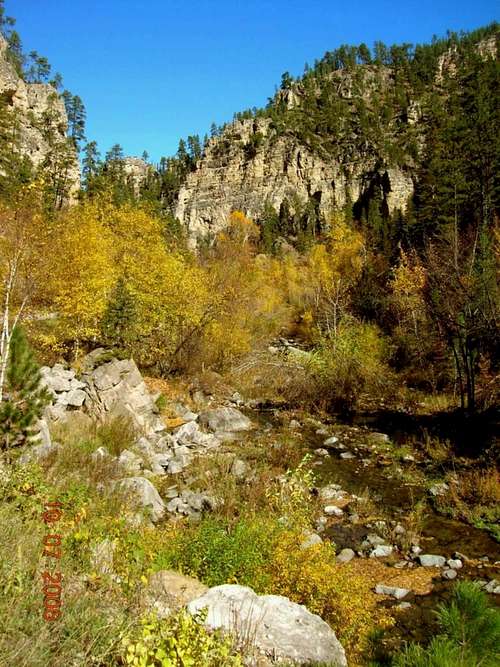
The canyon is a regional favorite for hiking, climbing, biking and sightseeing. Spearfish Canyon is renowned for the fall colors each year. The high limestone cliffs, along with various waterfalls, add much to the photo opportunities here. The canyon and surrounding hills are full of aspen, birch, Ponderosa pines, spruce, oaks, and box elder trees. Wildlife seen in the area includes mountain goats, deer, porcupines, raccoons, bobcats, and occasionally a mountain lion. Eagles are often seen floating down from the high walls of the canyon.
Geology & History
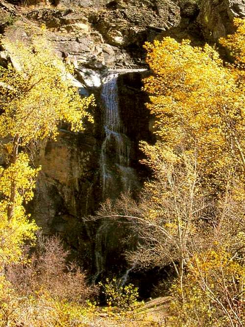
Bridal Veil Falls
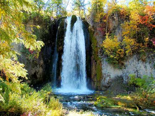
Little Spearfish Falls
There are three distinct layers of limestone that make up the walls of the canyon. The lowest level is Deadwood Sandstone, ranging from 10 to 400 feet thick. The middle level is comprised of Englewood Limestone, ranging from 30 to 60 feet thick. The top level is comprised of Paha Sapa Limestone, laden with fossils, and usually from 300 to 600 feet thick. In some places, the canyon walls are over 1,000 feet high. The canyon also has igneous rock intrusions, most notable in places like Bridal Veil Falls.
Roughly 20 miles long, the canyon was carved by Spearfish Creek. When one observes the small stream flow in some parts of the creek, it’s puzzling how such a mighty canyon could have been carved out by it. But, before mankind started reducing the stream flow, it was once known as the Spearfish River, the second largest stream to come out of the Black Hills. The one major branch in the canyon follows the path of Little Spearfish Creek. There are other, small side branches, like the Iron Creek branch or the Eleventh Hour Gulch (so named because it is so steep that direct sunlight only gets in for about one hour a day).
The Spearfish Canyon area saw a huge influx of white settlers in 1876, during the Black Hills Gold Rush. That same year, the city of Spearfish, located at the mouth of the canyon, was first formed. A steam train route was built through the canyon in 1893, and operated until 1933, when a flood wiped it out. The train line went out of business, and the old bed provided the base for Highway 14A.
Canyon Activities & Opportunities

Ice Climbing in Spearfish Canyon. Photo by mikemcneil
Hiking opportunities abound in Spearfish Canyon, with numerous short trails, several long trails, and plenty of off-trail options.
Rock climbers report there are a number of major areas, and more than a hundred smaller routes possible. The quality of rock climbing in Spearfish Canyon would certainly warrant a separate page (or pages) by someone more knowledgeable than myself. Ice climbing is also reported to be excellent.
Cross country skiing is excellent on the Eagle Cliffs trail system that borders the south canyon area. Mountain biking is popular on some of the trails in the canyon, at Eagle Cliffs, and on Highway 14A (watch for bicyclists during your sight-seeing!). Geocachers love this area, and opportunities are plentiful.
There are incredible photo opportunities in Spearfish Canyon. Winter, spring, summer or fall, each season offers unique perspectives on the massive cliffs, peaks, streams, falls, wildlife, and foliage. The photos on this page barely begin to do this beautiful area justice. SummitPost members are invited to add their photos to the Spearfish Canyon Gallery.
How To Get There

Spearfish Canyon Foliage
Most people access Spearfish Canyon from the city of Spearfish, located on Interstate 94, along the northern edge of the Black Hills.
Others prefer to create a scenic route through the Black Hills, coming in from Deadwood and Lead by way of Highway 85, turning north at Cheyenne Crossing and entering the canyon on Highway 14A from the south. Of course, there are other options available, but these are the most common in South Dakota.
If you are traveling to Spearfish Canyon from Newcastle Wyoming, by way of Highway 85, it is 44 miles to the Cheyenne Crossing junction with Highway 14A.
Red Tape

Roughlock Rapids
Since most of the land in and along Spearfish Canyon is public, the only real restrictions are respecting private property and complying with posted regulations. A careful adventurer in the canyon area will also check for official advice on hunting seasons. If you must be there during hunting seasons, be sure to wear orange. Those planning a visit can check season dates by clicking here:
South Dakota Hunting Season Dates
Inquiries can also be directed to their office:
South Dakota Game Fish and Parks
523 East Capitol Avenue
Pierre, SD 57501
605-223-7660
Spearfish Canyon Trails
Eleventh Hour Gulch Hikers
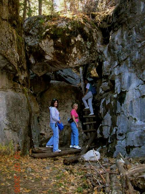
There are official trails in and around Spearfish Canyon, and there are unofficial trails. If you venture off the regular trails, be it an unofficial trail or just bushwhacking, be sure someone knows your plan. Some of the area is extremely rugged and hidden. Being injured in one of the rarely-visited areas could prove disastrous. The list and description of trails below is not exhaustive, but provides an overview of most of what is available. The distances to these locations have the Highway 14A intersection with East Colorado Boulevard in Spearfish as the mileage reference point.
76 Trail – This short ¾ mile trail quickly ascends 1,000 feet up the canyon wall to Buzzard’s Roost, providing an excellent view of Spearfish Canyon and Little Spearfish Canyon. The trailhead is at Savoy (13.2 miles from Spearfish), the junction points of Spearfish and Little Spearfish Creeks, as well as Highway 14A & Road 222 (the Roughlock Falls Road).
Spearfish Canyon Floor Trail – The trailhead is behind the Spearfish Canyon Lodge at Savoy. This short ¾ mile loop trail descends to Spearfish Falls.
Roughlock Falls Trail – This trail starts near the Spearfish Canyon Lodge at Savoy. It is an easy 1-mile trail to Roughlock Falls, and is also wheelchair accessible.
Rimrock Trail – There are upper (4.5 miles) and lower (3.5 miles) loops that share a common segment for a short distance. Hiking just the outer parts of the two trails makes a 6.5 mile loop. The trailhead for the lower loop is at the Rod and Gun Campground near Road 222 in Little Spearfish Canyon, while the trailhead for the upper loop is a couple miles further up the road at Timon Campground. Timon Campground is also the trailhead for the Little Spearfish Trail. Both loops have segments along Little Spearfish Creek and both have segments through forest areas. The lower loop also ascends the canyon wall to the rim for some great views. The upper loop ascends to over 6,000 feet and passes a junction with the Old Baldy Trail, an old ranger station, and an old rock quarry.
Little Spearfish Trail - The trailhead for this 5.7 mile loop is also at Timon Campground. The trail ascends to a maximum altitude of 6,280 feet, through a forested area usually well-populated by deer and elk. Eventually, the trail drops to a route along Little Spearfish Creek and numerous small trout ponds.
Iron Creek Trail – This trail is out-and-back, 1.3 miles long. A parking lot on the west side of Highway 14A is located about 11.5 miles into Spearfish Canyon, or 1.7 miles north of Savoy (Highway 14A & Road 222). Follow the trail along Iron Creek and enjoy the rock formations.
Eleventh Hour Gulch – This very narrow side canyon is a local favorite, but finding a place to park could pose a problem. The access is 9.4 miles into Spearfish Canyon along Highway 14A, 3.8 miles north of Savoy. The short trail to the gulch (west side of road) could very easily be missed, with no signs marking it. To go far into the canyon involves some climbing and very uneven rocky terrain. A small stream trickles through here.
The Devils Bathtub – This is another unmarked trail near Spearfish Creek. About 8 miles up the canyon along Highway 14A, you will see “Cleopatra Place” on the east side of the road. Turn in there and park wherever you can find a place. Cross the bridge and turn right, following the little creek (not Spearfish Creek) up stream for perhaps ¾ mile. The stream has carved several swirled “bowls” along the route. You will have to do some wading, so be prepared for that.
Eagle Cliffs Trails – This trail system is not in Spearfish Canyon, but is very close by. The trails are often used for cross country skiing, and also serve for hiking and mountain biking. The Eagle Cliffs trailhead is 8.4 miles southwest of Lead, SD along Highway 85.
When to Hike or Climb

Autumn along the Iron Creek Trail

Autumn colors in Spearfish Canyon
The northern Black Hills receive substantially more snow than the rest of the hills. The snow depths in Spearfish Canyon can at times prevent hiking or climbing. Ice climbing is a different matter, with abundant opportunities when regular rock climbing and hiking are not feasible. To check out the latest forecast and conditions in Spearfish Canyon, click on the link below:
Spearfish Canyon Weather Forecast & Conditions
Maps
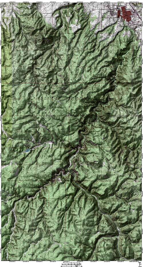
Spearfish Canyon Map is courtesy of Bubba Seuss
A very good map for roads, trails, and features in the area is National Geographic “Black Hills North” edition.
The USGS maps for the canyon are Spearfish, Savoy, and Maurice.
The National Forest Service also offers a free road map for the area, helping visitors to know which forest service roads allow access. These can be obtained from most forest service offices in the Black Hills.
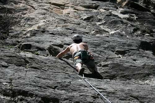
Spearfish Canyon Rock Climbing photo by jharrwyo
Camping & Lodging Resources
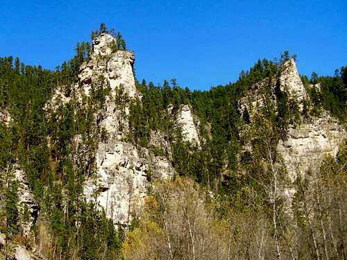
Majestic Rock Formations in Spearfish Canyon
Timon Campground
605-673-9200
Rod and Gun Campground
605-673-9200
Iron Creek Lake
605-642-5851
Hanna Campground
605-673-9200
Spearfish Campgrounds and Lodging
605-642-2626
Spearfish Canyon Lodge
605-584-3435
Other Resource Links

Roughlock Falls
Northern Hills Ranger District
605-673-9200
Spearfish Chamber of Commerce
800-626-8013, 605-642-2626
Spearfish Canyon Foundation Hiking
South Dakota Game Fish & Parks