
-
 5231 Hits
-
 81.18% Score
-
 13 Votes
|
|
Canyon |
|---|---|
|
|
43.55480°N / 103.4663°W |
|
|
Hiking |
|
|
Overview
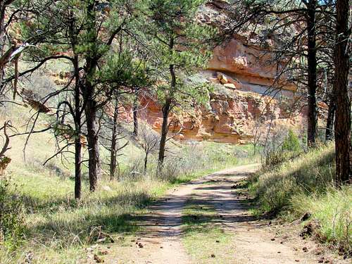
Wind Cave Canyon Trail
For those who enjoy exploring canyons, one of the top choices in the Black Hills is Wind Cave Canyon. Thousands of visitors come to see the famous cave that is located at the bottom of the canyon in the heart of Wind Cave National Park. Many also take the time to hike one or more of the trails. This canyon system is about 10 miles long, with the head of the canyon on the south side of the Twin Sisters Range, and the mouth of the canyon at the junction with Beaver Creek. Wind Cave Canyon is joined by several small side canyons, most notably Cottonwood Creek, Prairie Dog Canyon and Negro Canyon. Elk Mountain and Elk Knob are located on the south side of the upper canyon.
The canyon floor drops around 900 feet over the course of the 10 miles and there is no steady stream flow throughout the entire length of the canyon. When stream flow is encountered, it is usually from a large spring in a canyon bend, and usually returns underground within a quarter-mile from the spring. Flash floods through the canyon have left some impressive debris behind providing hikers incentive to pay attention to weather conditions. Runoff from heavy rains can and does create hazardous conditions on the canyon floor.
Wind Cave Canyon is characterized by some grassy slopes and some forested slopes plus limestone and sandstone walls that vary in height from less than 100 feet to 400 feet in other places. Caves are found in some locations in the canyon, with of course Wind Cave being the most noteworthy of these. While ponderosa pine is the most common tree in the region, other varieties of trees include aspen, birch, cottonwood, oak and ash. Buffalo are the most commonly seen large animals in the canyon. But, visitors to the canyon might also see elk, pronghorn, deer, mountain lions and coyotes. A variety of snakes are often found in and around the canyon. Rattlesnakes are of particular concern, and Wind Cave National Park posts notices to that effect.
Getting There

Wind Cave Canyon Sentry Buffalo
Wind Cave Canyon is usually accessed from Highway 385, which runs through the middle of Wind Cave National Park. The Wind Cave Canyon Trailhead is approximately 10 miles north of Hot Springs, while the turnoff for the Wind Cave National Park Visitors Center is about 1 mile southwest of the Wind Cave Canyon Trailhead, or about 9 miles north of Hot Springs.
Past the national park boundaries and at the extreme western end of Wind Cave Canyon, forest service roads 373 and 373.1D give access to a very old road that follows the course of the upper canyon almost to the Wind Cave National Park boundary. This road is closed to motorized vehicles, but makes a good hiking route, plus provides access to the eastern part of the Twin Sisters Range.
Route Options
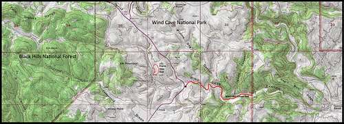 Wind Cave Canyon Map
Four distinct stretches in the canyon help identify possible exploration routes. The uppermost section is on national forest land and runs from the head of the canyon to the national park boundary, accessible from FSR373 as an off-trail hike. The next section would be from the park boundary by Elk Mountain Campground past the Visitors Center and to Highway 385. The Prairie Vista Trail provides the only hiking route in this part of the canyon. The third section begins at Highway 385 and continues eastward to the park boundary. The Wind Cave Canyon Trail covers this section. The fourth section is on the old Sanson Ranch, which was recently acquired by Wind Cave National Park. Due to transitional legalities, no general hiking is allowed there yet. However, there are summer hikes led by Wind Cave Park employees onto the old Sanson Ranch. For more information about those hikes, call (605) 745-1134. The two trails listed below cover the public trail options.

Trail View

Prairie Vista Trail
Wind Cave Canyon Trail is a 1.8 miles (one-way) route to the eastern boundary of national park. This old road is still used by national park service vehicles, but is not open to any other vehicles. This is the most scenic and most popular hiking route in the canyon. The trail includes a nice mix of shade and sun. At the trailhead, you will find warnings to be alert for rattlesnakes, poison ivy, ticks and hostile buffalo.
Prairie Vista Trail is a 1-mile loop trail partly on the canyon floor and partly over adjacent prairie that passes through the picnic area just to the north of the Visitors Center.
Red Tape
Red tape will vary depending on what part of Wind Cave Canyon you wish to explore. If the need arises, please check with the agency (see below) that manages the section you wish to explore and need more information for. For the most part, you can hike the public areas year-around without any red tape. It is when people want to use firearms or build campfires where potential problems could arise. Fossils and unusual rocks are abundant in the area. Removal of fossils and rocks from public lands is illegal.
When to Explore

Bullsnake in the grass
The area can be explored year-around, weather permitting. Because of flash flood potential, you will want to stay up-to-date on the weather. You can find out more by clicking here:
Wind Cave National Park Weather
Hunting is not allowed in Wind Cave National Park, so this should not be an issue during any part of the year. However, hunting is allowed on the national forest land on the uppermost parts of Wind Cave Canyon. You can learn more about the hunting seasons by clicking on this link:
Black Hills Hunting Seasons
Camping & Lodging

Camping in the National Forest portions of the upper canyon are regulated by Black Hills National Forest Camping Regulations. Wind Cave National Park does not permit camping along the trail, but does have its own campground that is actually located in Wind Cave Canyon. Canyon visitors may also camp at the nearby Cold Brook Reservoir’s campground. For more information, please click on the desired link below:
Black Hills National Forest Camping
Wind Cave National Park Camping
Cold Brook Reservoir Camping
Information & Links for Management Agencies

Wind Cave Visitors Center
Black Hills National Forest (605) 673-9200
Wind Cave National Park (605) 745-4600
Useful Maps

Wind Cave Canyon Spring

Buffalo Scratch Post
Wind Cave National Park posts maps for their park trails. You can view their trails page and maps at this link:
Wind Cave National Park Map
Good maps for the area include the Black Hills National Forest map and the Black Hills South map published by National Geographic. Both maps can usually be purchased at area forest service offices. When you are there, you can also get a free Black Hills Motor Vehicle Use Map that will guide you to all currently accessible forest service roads.