
-
 11015 Hits
-
 83.69% Score
-
 17 Votes
|
|
Mountain/Rock |
|---|---|
|
|
47.33600°N / 10.86200°E |
|
|
Hiking |
|
|
8179 ft / 2493 m |
|
|
Overview
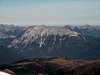
Wannig, also popular under the name Hochwannig, is not a very difficult mountain, but it looks impressive and offers even more impressive views. Marking the west end of the Mieming Range Lechtaler Alpen are very close. Because of its steep slopes to the south it offers great views to the Öztaler and Stubaier Alpen. To the north a impressive rock wall of about 300 metres in height catches your eyes. The easiest route to the top is from Nassereith via the west side of Wannig. This route is very steep and climbed by a lot of people. More interresting is the double traverse of Handschuhspitzen and Wannig from Biberwier.
 | 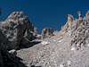 | 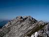 |  |  |
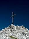
Summit views
 | 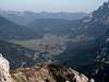 |  |
Maps and routes overview
Maps:| 1:50 000 | KOMPASS #5 Wettersteingebirge Zugspitzgebiet, good overview map |
| 1:25 000 | Alpenvereinskarte 4/1 Wetterstein und Mieminger Gebirge West, more detailed map (useful if you give Wannigs north ridge a go) |
Routes: From Nassereith Trailhead is in Nassereith. Trail 25 leads trough the Brunstwald (a forrest) up to Schnahnggenkopf (1825m / 5987ft). From there trail 26 turn east. Following the very steep west slopes over stones and scree you' ll reach Wanning within 2 hours.
Traverse via Handschuhspitzen Trailhead is a parkinglot in Biberwier. Barberasteig starts directly at this parking lot and leads up to Marienbergjoch (1798m / 5899ft). From there trail 30 turns west and crosses the steep scree field up to Handschuhspitze (2319m / 7608ft). Follow the path along the easy ridge with its steep slopes to the south to the summit of Wannig. Descent trail 26 and turn right onto trail 25, which leads you back to Marienbergjoch and Biberwier.
Wannig norht ridge Difficult route starting in Biberwier. Follow Barberasteig up to Marienbergjoch. From there trail 25 leads west. On the left side (south) a path leads up to Wannigs north ridge (UIAA II, exposed, steep). Descent trail 26 and back to Marienbergjoch.
Getting There
There are two trailheads.If you' re planning to traverse Wanning via Handschuhspitzen (2319m / 7608ft), the parkinglot of a summer-toboggan run at the south end of Biberwier is your goal. Otherwise parking in Nassereith o r at Fernpass is better, because you' re reduceing your way to go.
Biberwier, Fernpass and Nassereith are connected via road 179 (Fernpass). From Nassereith you have a road / highway connection to Innsbruck (airport). From Biberwier a road leads vie Ehrwald to Garmisch Partenkirchen (Germany) and Munich (airport).
In Ehrwald a train station exists, but reaching the trailhead is very difficult, because of the distance of about 10km. (I don' t know if there is a bus connection...)
Red Tape
There are no permits, fees or seasonal closures! Parking is free, but the parking lot is not very big! A cable car to Marienbergjoch (from Biberwier) exists.
When To Climb
Wannig can be climbed all the year, but mainly it is summitted in summer.On summer weekends, the traverse via Handschuhspitzen is not the right place to find a quiet place. Because of its difficulty, Wannings north ridge (UIAA II) is seldomly climbed.
In winter, Wannig offers a lot of different possibilities, to proof your alpine skills. Doing the travers via Handschuhspitzen is tricky, because of the steep south slopes of Wannig. The north side offers many ski-tours. Check avanalche reports before atempting to summit Wannig in winter!
Camping
The area around Ehrwald (including Biberwier) is a very touristic area with many hotels and camping sites. For more information visit the homepage of the area of Ehrwald.I think, camping on the mountain itself is not allowed.
There are two major huts on the mountain:
Muthenaualm - A private hut with no bedrooms, but here you can reload you batteries with a cool beer.
Waldhaus Talblick - Some sort of hotel a few metres above Biberwier.
Mountain Conditions
Webcam: | Webcam near Ehrwalder Alm. Displays current weather information (temperature, humidity and wind speed) and has a live streaming. This webcam is about 5km from Wannig | |
 | Webcam in Biberwier. View direction towards Wannig (south). |
Weather:
| www.wetter.com (Biberwier) | Weather forecast of Biberwier on the north side of Wannig. |
| www.wetter.com (Nassereith) | Weather forecast of Nassereith on the south side of Wannig. |