
-
 17414 Hits
-
 77.48% Score
-
 8 Votes
|
|
Route |
|---|---|
|
|
9.1167°S / 77.6167°W |
|
|
Ice Climbing |
|
|
Summer |
|
|
Expedition |
|
|
D to TD- |
|
|
10 |
|
|
Overview
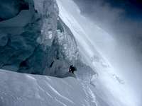
The West face of Huscaran South offers a tremendous variaty of ice climbing. The face is called "El Escudo" ("The Shield") for its peculiar triangular shape.The longest line on the face has about 450 metres elevation gain. The nclination and difficulty on the face changes according with the inclination and nature of the ground. The leftmost line - by fare the most frequently climbed route - is over ice and neve with a slope of 45°-50° and starts at 5,900m, goes on an arête to get at about 6,250 on the top of the face. Lines further right gets steeper and on harder ice. On the left the face get as steep as 60-65° - a couple of pitchs at 70° - and the ice gets harder and more fractured.
On the "Shield" there are probably Huascaran's safest routes as there is nil risk of objective danger (avalanches, seracs' fall). On the other hand the routes are technical and require good proficiency with ice tools.

Getting There
The West face starts at about 5,800m and ends at 6,250m. Getting there is quite straightforward. Follows the normal route and once crossed the infamous "Canaleta" and passed a few enormous seracs leave the route on its right at about 5,900m just before getting to the camp 2. The arête of the shield is clearly visible at this point where there is a safe and convenient camping spot, the route starts at the base of the arête where it is possible normally to find a passage across the big berschrund that goes all the way long over the base of the face.If your intention is to climb on a more direct line you need to cross the berschrund on the left side on the face and this very likely requires to leave the normal route at a lower altitude unless you don't want to cross the berschrund at 5900m and after traverse a long icy section at 50° or more (personally I don't like this kind of traverses). In July 2007, when we opened a new direct line starting from the right side of the base of the "Shield", the most convenient option was to camp in a safe place in the "Canaleta" at about 5650m, leave the normal route at about 5,700m (go high qnd right where the normal route is quite flat) and traverse the berschrund at about 5,800m.
Route Description
Letfmost route (arête) - Difficulty: DThis route is the line followed by 95% of the people climbing the West face. it is classified D+ on all climbing guides, we believe D is a more appropriate grade. The route is straight, over a safe, continous ridge with a slope of about 50°. There is nil objective danger, on the ridge you will find some ice but the ground is mainly good, compact nevé. The route starts at about 5,900m, head for the solid rocks marking the top of the face and once there follows the snow ridge that in 2-3 hours leads to the summit. Slope will decrease progressively and about one hour after the rocks you should be able again to walk. Descend by the normal route. There are about 4 hours to climb the arête, then 3 hours for the summit and from there 3 hours from back to your tent. Early start is essential (eg 2am) if you want to return back to your tent before sunset; times above are for a strong and competent party.
Rightmost route (direct, face route) - Difficulty: TD-
Michael Ybarra (USA) and Silvio Sparano (Italy) opened the route on July 2007. The route follows a direct, aesthetical line starting at 5,800m on the right side of the West face. Once the berschrund crossed, climb about 10-12 pitchs of ice and hard snow at about 60-65° (some short sections are steeper). The ice is hard and fractured at the beginning (clean the surface before placing your ice protections) and gets progressively nevé as long you climb higher. We did not find any "plastic ice" in opposition to the common belief of most of mountain guides in Huaraz.Descend by the normal route. There are about 7 hours to climb the face, then 3 hours for the summit and from there 4 hours from back to your tent (you will need to get lower than if you had climbed the arête). Early start is again essential (midnight); times above are for a strong and competent party.


Manning - Jan 10, 2009 12:04 am - Hasn't voted
Earlier AscentMatt Wells of Hailey, Idaho and I did an earlier ascent of the direct route up the West Face of Husacaran in July of 1977. At the time, we felt is was the first but who knows? Ice tools at the time were not as advanced as they are now. We were unable to get any of our Salewa ice pins or screws in due to the extreme hardness of the ice. We effectively freed the whole route albeit we were roped together the whole way up which in retrospect may not have been wise. It was a very challenging route mentally and physically, it turned out to be my last climb. Matt however and much to his credit continues to climb in South America. Dan Manning