
|
|
Route |
|---|---|
|
|
47.33990°N / 113.883°W |
|
|
Hike, scramble, basic snow climb |
|
|
Most of a day |
|
|
Scramble |
|
|
Approach
From St. Ignatius, take the St. Mary's Lake Rd. south a few miles, then turn left on Mission Dam Rd. Take this road as far as it goes, across the canal and all the way around Mission Reservoir to the trailhead to Mission Falls and Lucifer Lake. The trail starts where the road ends (the last mile or so of road is pretty rough).
Route Description
The first few miles of the trail goes through the lower part of the canyon and is fairly easy. Not much elevation gain until you reach the lower falls (which the trail goes right next to). From here it gets more difficult. The trail becomes much steeper and has a few splits here and there. Just try to stay on the most well-worn path and you'll be all right. Continue on for another few miles until you get to Lucifer Lake.
From here you'll get your first view of Mountaineer, barely peeking up behind unnamed peaks in front of it, on the far right side of the Garden Wall. Cross the outlet of Lucifer and go around the south side of the lake. IMPORTANT: DO NOT try to leave Lucifer's basin here to get out of the brush -- you'll only get in deeper. There is a weak, but welcome, trail that follows very close to the lake's shoreline. Follow it to the other side of the lake.
From here you'll be tempted to head for the lowest section of the drainage that connects Lucifer Lake to Picture Lake 500 feet above, but it's actually easier if you stay to the left of that. It's a little more elevation gain (and loss when you drop a little into Picture), but there's less brush. The bottom near the lake is brushy everywhere, but once you clear that, try to head more in a straight-up direction instead of angling to the low section to the right. You'll save time in the end.
Once you get to Picture Lake, pick your way through the boulder field on the north side of the lake and then side-hill some steep, grassy terrain on your way to the Garden Wall. Try to angle your way up this side-hill part slightly to avoid some brush on Picture's east end. About halfway between Picture and the Garden Wall there is a Bear Lure Station. It is marked with signs, but the signs are only about 20 feet or so from the actual station. The station is simply some barbed wire set up in a small square with something to attract bears buried under some deadfall within the wire. I guess to get some hair samples from the barbed wire? I don't know, but it's something to be wary of.
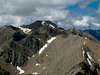
The terrain opens up as you approach the Garden Wall. There is a small stream that flows year-round here. This is a good place to take a break and get ready for the steep part of the climb. Mountaineer looms almost directly above you here -- less than one air-mile and 2,500 feet up.
From here, the route is obvious. Take the narrow canyon to the south between Mountaineer and the unnamed peaks to the west of it. If you're doing this climb any time before July you may want to bring an ice axe and crampons, depending on what kind of winter we've had. The first 500 feet or so up the canyon is the steepest, with loose smaller rocks turning into small boulders near the top of this section. Once on top of this, the bottom of the canyon isn't quite as steep and will most likely be covered in snow through mid-July. Later in the year it's one long rock field.
Take the canyon all the way up to the little cirque at the top. There are a couple of large boulders here surrounded by grass and, in early summer, some runoff water. The peak is about 1,000 feet above you here, looking east (and up!). There are two ways to go: You can angle over to the saddle to the right of the peak and follow the ridgeline up, or simply go straight up. The hillside from here is very fine loose dirt and gravel with a little bit of vegetation mixed in. It gives away fairly easily, so be careful. It's much easier coming back down, however, if you take the ridge over to the saddle and then angle back to the canyon.
 |  |  |  |  |
Essential Gear
If you do this route in the summer and fall months, you won't need anything extra. I would recommend at least an ice axe for any climbs up until June, and that just for the steep, shadowed 500 feet or so at the bottom of the canyon leading to the summit.
Miscellaneous Info
If you have information about this route that doesn't pertain to any of the other sections, please add it here.