
-
 25943 Hits
-
 85.88% Score
-
 22 Votes
|
|
Mountain/Rock |
|---|---|
|
|
47.33990°N / 113.883°W |
|
|
9261 ft / 2823 m |
|
|
Overview
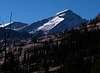
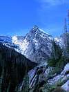
-Mountaineer Peak domintates the eastern view of the Mission Mountains from the Swan Valley near Seeley Lake. It can also be seen on the looker's-right side of the Garden Wall from the Mission Valley near St. Ignatius. It is accessible from the Crystal Lake/Lost Lake area of the Mission Mountains Wilderness (east) or the Lucifer Lake area of the Mission Mountains Tribal Wilderness (west).
-The approach/climb involve trail hiking, bushwhacking, scree fields, boulder fields, scrambling, and alpine snow climbing.
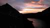
-On a clear day, the view from the summit includes much of the Mission Mountains. To the east are the lake basins of High Park, Lost/Crystal, and Turqouise/Glacier with the Swan Range and Bob Marshall Wilderness in the background. To the west, one can see the Sonielem Ridge, Lucifer Lake, and the actual farmland of the Mission Valley. North of the peak are the Garden Wall and Mountaineer Glacier, and far off to the south it is possible to see Lolo Peak in the Bitterroots.
 |  |  |
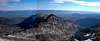
Views from the top
Photos taken October 2003
 |  |  |  |
Getting There
CAR: (EAST)
From Missoula, drive east on I-90 to Bonner, then continue east/north toward Great Falls on Highway 200. Turn left toward Seeley Lake on Highway 83 at the "Stoney's" bull. Drive past Seeley, and turn off at road 79 to Lindbergh Lake, but don't turn off toward the residential area or on logging roads. After several miles, the road ends up at the trailhead.
FOOT: (LOST LAKE)
Walk downhill on a good trail to Crystal Lake. The trail fades away about 3/4 of the way around the lake, and there begins the bushwhack.
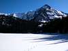
Follow the first big creek to enter the lake that comes from the northwest to Lost Lake. This bushwhack is swampy down low by Crystal Lake and has thick forest with lots of deadfall and thick cedars for most of the rest. There is one difficult stream crossing (we chose to bridge it on a wet, mossy log), and a 20+ foot cliff (with a longer distance to roll) that must be climbed. After this cliff, the terrain opens up to alpine and is much easier to travel until Lost Lake. There, traverse the north shore, which is a long, steep, gravel-sized scree field, to the valley northwest of Lost Lake at the base of Mountaineer.
 |  |  |
Red Tape
-The eastern side of the Mission Mountains Wilderness is a federal wilderness, and is therefore free and usually open from the directions above.
-The western side is the Mission Mountains Tribal Wilderness, and requires a daily (or season) license and camping stamp from the Confederated Salish & Kootenai tribes, purchasable throughout the region. Prices vary for Flathead residents, Montana residents, and out-of-staters.
-North of Mountaineer Peak in the tribal wilderness is the Grizzly Bear Conservation Zone, which has seasonal closures, but no direct approach to Mountaineer passes through this area. This being said, their is the potential for grizzlies to be around Mountaineer, as well as black bears, mountain lions, moose (especially lower), and goats (especially higher). Other dangerous wildlife around Mountaineer include gear-destroying rodents.
 |
When To Climb
The last snowdrifts usually melt off the road in the end of May, but the winter stays up high several weeks later.
The east face appears particularly avalanche-prone due to the funnel shaped bowl of the looker's-left side (which had recent avi debri when we were there in October) and the smooth, steep, terraced cliffs of the looker's-right side, so I would not even go up there when there is a lot of snow. As I said, we were there in October, and just a little fresh snow dusted a solid snowpack that had been there all summer.
As for weather, I have noticed the Missions tend to be really windy, especially at night. On Mountaineer Peak, you will not be able to see any weather coming from the west until it is on top of you. I will not try to predict seasonal weather, but I would think that autumn (few thunderstorms, warm days/cool nights, little snow) would be best to climb.
Camping
-If you camp at Crystal Lake, do not camp in the first sites you see as they are closed (and well marked) for restoration. There are lots of good sites farther up the trail near the north shore.
-There are no campsites along the steep shorelines of Lost Lake, except for a rocky peninsula that is too close to the water to be legal. The only camping is in the valley to the northwest of Lost Lake, where there are flat spots and a clean creek but lots of wind.
Mountain Conditions
You can drive up and look at Mountaineer from Summit Lake to past the turn off to road 561 (best view of east face) on Highway 83.