
-
 10032 Hits
-
 81.18% Score
-
 13 Votes
|
|
Area/Range |
|---|---|
|
|
40.75760°N / 110.91205°W |
|
|
Hiking, Sport Climbing, Scrambling, Skiing |
|
|
11340 ft / 3456 m |
|
|
Overview
 Cliffs of the East side of the main ridge
Whiskey Island Mountains are a group of Uinta 11'ers stretching S to N from Lofty /Scout / Cutthroat Pk to Mt Marsell, Teal Peak, Cuberant Peak, and finally Whiskey Island Peak, along an uninterrupted high ridge.
 The wide main crest of the central part of the ridge
This 5-miler high ridge, home to a half-dozen accessible 11'ers, stands at the triple divide of the basins of the Great Salt Lake (Weber River), Bear Lake (Bear River), and the Pacific (Duchesne River). The ridge zigzags in a general NW-SE direction, with the North and South-facing aspects typically most accessible, and the East facing sides typically the cliffiest.
The Southern-most part of the range already has good descriptions from Scott Patterson, while the 3 less-visited Northern-most peaks are pretty much a blank slate now.
 Rocky pillars of Mt Marsell
Weber River quickly burrows into a poorly accessible gorge, and thus approaches to the range are almost never done from the West side. Most of the visitors head for the few popular lakes on the South-East end of the massif, especially the crowded Ruth Lake. One hardly needs to gain an elevation to reach the lakes. The high altitude forests and meadows provide for easy off-trail travel, but keep in mind that people do get lost and sometimes disappear in this lake country.
More adventureous hikers and horse riders take Lofty Lake Loop trail, crossing between the low-slung Cutthroat / Scout peaks (both are alternatively known as Lofty peaks, due to their location next to this famed windswept lake, the highest in the Western Uintas). The peaks, and the entire Northern part of the range, are a place to find solitude.
Peaks, North to South
 Whiskey Island Peak, South Ridge
 View of High Uintas from Whiskey Island Peak
Whiskey Island Peak 11,340
This peak is the most alpine-looking in the whole range, and also the highest and probably the least accessible. It is shaped by the junction of three steep ridges, and can be climbed along either of them. Both SE and NE faces are cliffy, while the NW side is very steep but not as crisscrossed by cliffbands.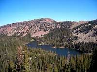 Cuberant Peak and Cuberant Lake
 Summit ridge just East of Cuberant Peak
Cuberant Peak 11,250
The Western-most of the 11'ers of this mountain group, Cuberant Peak is most easily ascended from the South, from Cuberant Lake. The East face consists of cliffs and rockfall-prone coloirs.A long, prominent NW Ridge almost reaches the 11,000 level again in a mile from Cuberant Peak. This spur ridge, although wide at the top, has impressive dropoffs both on the Fish Lake side and on the Weber Canyon side. The easiest place to gain this spur ridge is in approximately half-mile East from Fish Lake.
The main ridge of Whiskey Island Mountains, although bouldery and narrow in places, has only 200 ft altitude drop between Cuberant and Teal peaks, and 300 ft towards Whiskey Island Peak.
 Rocky East Face of Teal Peak
 North slopes of Teal Peak offer easier route options
Teal Peak 11,187
This peak is adorned with spectacular cliffband around the NE bow of the mountain, but it is easy to access from any other direction.Between Teal and Whiskey Island peaks, a wide-open bowl with unnamed lakes, meadows, and streams is an amazing place of solitude even though it is barely 3 miles from the highway.
 Cliffy South aspect of Mt Marsell
 From the high plateau of Lake Lofty, Western Uinta's highest, Mt Marsell looks close and insignificant
Mount Marsell 11,340
At 11,340 ft, Mount Marsell shares the distinction of being the highest in the group with Whiskey Island Peak proper. The peak is usually climbed from the North-West (Cutthroat Lake area) or from the pass to the South-East. South and East aspects have some spectacular cliffs. The ridge connecting with Teal Peak to the North is wide and gentle, dropping no more than 350 ft in between.The peak has a very detailed SP page written by Scott Patterson.
 Cutthroat / Lofty Peak rises beyond popular Ruth Lake
 Cutthroat Peak is dwarfed by its 12er neighbors
Cutthroat / Lofty / Scout Peaks 11,158 / 11,113
Both peaks 11,158 and its sister peak 11,113 are sometimes referred to as "Lofty Peak", after a high lake nested between the two, from which both peaks are typically climbed. The higher one is also known as Cutthroat Peak, and the lower one as Scout Peak, after nearby lakes.The two peaks share a detailed SP page written by Scott Patterson.
The high Eastern spur of these peaks, just shy of the 11,000 mark, has a relatively popular rock climbing area (see below).
Getting There
Most of the trailheads are located on Mirror Lake Highway (UT150) which connects Kamas, UT, with Evanston Wyo. An exception is Fish Lake TH, near Holiday Park on Weber Canyon Road (UT213). In winter, SR 150 is not plowed between Soapstone Turnoff (MP14) and Bear River Lodge, and SR 213 is not plowed beyond S&M turnoff, so there is no easy access to Whiskey Island mountains. Cuberant Lake trail circles around the base of Mount Marsell
 Ruth Lake. The connector trail to Lofty Loop continues to the wide saddle ahead.
Lofty / Cuberant Lakes Trails
Trailhead parking is located virtually across the road from the crowded Pass Lake, at MP 32.3 of the Mirror Lake Hwy. The main trail is a 4-miler loop circling Scout a.k.a. Lofty Peak and passing at the base of Mt Marsell and Cutthroat Peak. If you follow the loop clockwise, a third signed junction to the left (just beyond a pair of forestponds) is a Cuberant Lake spur.Ruth Lake Trail
A posted, improved TH is located at MP 35.6 of the Mirror Lake Hwy. A well-trodden trail to Ruth Lake is only a mile long, a host of lesser lakes is within another mile of easy off-trail hiking. A secondary trail continue in the WSW direction from the West end of Ruth Lake, first up a gully and then gently traversing the slopes of Peak 10,975, and merges with Lofty Lake Loop on a wide saddle at the east flank of Cutthroat Peak. Fish Lake
Fish Lake Trail
Paved Weber Canyon Road, from Oakley, ends at the gate of Thousand Peaks Ranch. An improved unpaved road continues upcanyon across the private land. The signed TH parking is on the left side of the road, just short of the developments of Holiday Park.Whiskey Island Lake Road
A jeep road takes off the MLH near MP 37, across from Kletting Peak plaque. There are numerous forks in the road. At the first fork, barely half mile from the pavement, both left and right roads could be followed to the vicinity of Whiskey Island Lake. On any subsequent forks, try choosing the most Westerly spur. In just over a mile you will be close to the base of the peakRed Tape
Mirror Lake Highway is a fee demo area, and daily or annual pass is required. Ruth Lake TH easily overflows on weekends and illegally parked cars are sometimes ticketed. Fish Lake TH is a small parking spot amidst private property where any roadside parking is illegal.Campfire bans may be in force during the height of the summer season.
Camping
The nearest designated campground are Mirror Lake and Moosehorn to the South and Sulphur CG to the North. Dispersed camping is allowed up to 10 days, at least 200 ft away from the lakes and streams.Ruth Lake Climbing Crags
 Crags South of Ruth Lake are perhaps the most popular rock climbing spot in the entire Uinta Range.
The image on the right (from backcountry.typepad.com) shows one of the bolted routes with Ruth and Naomi Lakes down below, and Whiskey Island Peak on the skuline beyond.
Search for Garrett Bardsley
Garrett Bardsley, a boy scout, disappeared in August 2004 South-West of Cuberant Lake, barely a few hundred feet from the campsite. Hundreds of volunteer-days of searching turned up nothing. At least the trail junctions are all marked now!Read more about the search at the website of the Support Group
Giudebook by Scott Patterson
 Scott's guidebook
Scott has traveled rather extensively in this part of the Uintas,and his "Western Uinta Backcountry Guide" remains the most authoritative printed source. A special half-price offer for the fellow SP'ers may still be valid - please inquire with the author!