
-
 25280 Hits
-
 86.37% Score
-
 22 Votes
|
|
Canyon |
|---|---|
|
|
38.54030°N / 78.3497°W |
|
|
Hiking, Trad Climbing, Toprope, Ice Climbing, Scrambling |
|
|
Spring, Summer, Fall, Winter |
|
|
Overview

Shenandoah National Park is the jewel of the Blue Ridge, and Whiteoak Canyon is the jewel of Shenandoah. Scenic hiking, technical climbing, and even swimming and ice climbing await here, and it is a place for all seasons. Spring features full streams and a weekly progression of wildflowers. Summer offers respite from the heat and humidity of the East and invites hikers to dip into the clear, cold pools along Whiteoak Run. Autumn shows vivid foliage, the last of the wildflowers, and migrating butterflies (butterflies also abound from mid-April through the summer). Winter yields solitude, quiet, clear skies, and ice-adorned cliffs, and during especially cold spells, the waterfalls freeze over and the ice on the cliffs is thick enough for climbing.
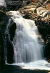
A trail winds and climbs through Whiteoak Canyon. No other trail in Shenandoah National Park offers as much as this trail does, and it ranks among the great day hikes in all the national parks of the United States. The principal lure of the trail is its waterfalls-- there are six major ones along Whiteoak Run, several smaller cascades, a seasonal fall on the canyon’s south side near the third fall, and another fall shortly upstream on Negro Run from where it crosses the trail just below the sixth fall. The sixth fall may be the most scenic because of its twin cascades, but each fall has its own charms. The fourth and fifth may be the most enjoyable since they are hard to see from the trail and are thus in relatively secluded settings. The falls are not the entire story, though—the entire stream is one of Shenandoah’s prettiest; dripping, moss-coated cliffs rise directly from the side of the trail in places; and old, beautiful trees tower in the limited level areas while smaller trees cling to steep hillsides and cliffs. And I did mention those wildflowers and butterflies? Sharp eyes will notice the other insects of the area and will spot the reptiles and amphibians, too.
The Waterfalls


Route and Gear Information
RouteFrom end to end, the Whiteoak Canyon Trail is about 5.2 miles long. It is easy to moderate between the upper end and the first fall, and many people starting from Skyline Drive make that section their hike (RT about 5 miles). The trail is quite steep, sometimes rocky, and often slippery between the overlook of the first fall and the base of the sixth. Between the base of the sixth and the lower end of the trail, the hike is mostly easy. Although a lot of people starting from the bottom hike to all six falls and back (RT about 6 miles), quite a few just go to the sixth and back (RT 3 miles), still a very nice hike in itself.
Except for late fall through early spring, when the leafless trees allow more visibility, the fourth and fifth waterfalls are hard to see from the trail. The easiest way to get to them is to look for an unmarked use trail going toward the brink of the sixth waterfall. From there, it's a short trip to the fifth fall and then to the fourth, but it can be difficult and dangerous climbing out from the fourth fall without taking on cliffs or a moist hillside that considerate people will want to avoid damaging. For most people heading upcanyon, it would probably be better to retrace the way they took until they reach the main trail again.
The Whiteoak Canyon Trail also links up with the Cedar Run Trail (Cedar Run drops through a canyon paralleling Whiteoak to its south), and the approximately eight-mile loop here makes a spectacular hike even better (see the attached route page). Cedar Run Canyon is steeper, narrower, and more rugged than Whiteoak is, and it boasts four waterfalls of its own plus a quieter setting. The Whiteoak Canyon trail system also connects to other trails that will take one deeper into Shenandoah’s backcountry.
A great and pretty easy hiking trip would be to leave cars at both trailheads and hike from top to bottom. This would require at least 60 minutes of driving between each trailhead, though.
Essential Gear
Sturdy hiking boots with good ankle support-- I see many obviously inexperienced hikers out here going in sandals and tennis shoes, and they are just asking for an accident.
Getting There


There are two trailheads. The upper one is between mileposts 42 and 43 along Skyline Drive, the paved road running north-south through the park. To get there from Luray or Warrenton (both in Virginia), take U.S. 211 east from Luray or west from Warrenton until the road crests the Blue Ridge and intersects the Thornton Gap entrance of Shenandoah National Park (this is about 40 miles from Warrenton). From the entrance station, where there is a fee (see RED TAPE), head south. Just past the second turnoff for the Skyland resort, look for a large, marked parking area on the left side of the road. This is the trailhead. People arriving from the south can access the park at Rockfish Gap between Waynesboro and Charlottesville or at Swift Run Gap between New Market and Ruckersville; then drive north to the trailhead. People arriving from the north can enter through the park’s northern entrance by Front Royal and then head south.
The lower trailhead is more remote. At Sperryville along U.S. 211, look for signs indicating 522 and 231 and follow the directions to them. Turn right on 231. You can also reach 231 via 522 from Culpeper, and you can take 231 all the way from Charlottesville. After about 10 miles along 231, you reach a tiny town called Etlan. Look on the east side of the road for a small convenience store. Directly across the road from the store is SR 643. There should be a sign indicating access to Whiteoak Canyon. Follow this road for about 4 miles until you reach a stop sign. Turn right (a sign for Whiteoak Canyon should confirm this). You are now on SR 600, and it takes you all the way to the signed parking area and trailhead, almost at the very end of the road. Instead of turning into the parking area, continue straight for about 0.8 mi to the end of the road, which is where the Berry Hollow Fire Road begins. It is about 5 miles from the junction of 643 and 600 to the trailhead, and the drive takes about 15-20 minutes.
Red Tape


To enter Skyline Drive, you must pay an entry fee and receive a seven-day permit. Currently, the fee is $15, but some parks have recently raised entrance fees. If you are paying cash, carry at least $20 to be safe.
At the lower trailhead, there is a fee of $5 per person to hike the trails. This collection occurs mostly on weekends in spring, summer, and fall, but be prepared anytime. An Annual or America the Beautiful Pass covers up to 4 people.
Annual passes are available and a good idea for people who visit the park frequently but don’t do much other travel to national parks. The pass was $30 the last time I noticed. The America the Beautiful Pass is available, also. If you plan on visiting several parks within a year’s time, this pass is a great bargain at $80; it provides admission for you and all in a vehicle with you to all U.S. national parks and other federal fee areas on Forest Service, BLM, and Fish and Wildlife Service lands for one year.
Arrive early on weekends or go on a weekdays. On sunny weekends in spring through fall, the parking lots at both trailheads will be crowded and may even fill. This is particularly a problem at the lower end since you cannot park along the road. The crowds will also guarantee no peace and quiet and may even affect your ability to take good pictures. Starting at or shortly after dawn will make for a much better experience.
Shenandoah is black bear country. You are unlikely to see any bears in the Whiteoak Canyon area, but you should still take proper precautions, especially with how you store food in the car. This is also raccoon country, and the raccoons can be quite adept at breaking into coolers and stealing food. Just lock all food in the trunk or in a covered area in the car, close your windows, and lock your doors.
To reduce poaching, Skyline Drive is subject to closures during hunting season. The information below, copied and pasted from the park site, illustrates the 2006 restrictions—
From November 13, 2006, through January 6, 2007
Skyline Drive
• between Front Royal (Mile 0 at U.S. Highway 340) and Thornton Gap (Mile 31 at U.S. Highway 211), and
• between Swift Run Gap (Mile 65 at U.S. Highway 33) and Rockfish Gap (Mile 105 at U.S. Highway 250),
will be closed daily between 5:00 p.m. and 8:00 a.m.
The central portion of the Drive, between Thornton Gap and Swift Run Gap, will remain open for overnight access to Skyland Resort and Big Meadows Campground until those facilities close on November 26.
Then, beginning November 27, 2006, through January 6, 2007, the entire length of the Skyline Drive will be closed daily from 5:00 p.m. until 8:00 a.m.
Camping


Camping options for Whiteoak Canyon are not very good. Big Meadows is about 10 miles south on Skyline Drive, and it fills most weekends from May through October, so arrive around noon when campers check out and sites open. Half the sites are reservable through the National Parks Reservation System (see park link below). There are three other developed campgrounds in the park, but they are all at least twice as far from Whiteoak Canyon as Big Meadows is. The campgrounds open in April, but they do not all open at the same time. They also close at different times, but all are closed from December through March.
Backcountry camping is prohibited in almost all of the Whiteoak Canyon-Cedar Run corridor. Private campgrounds outside the park are too far from the trailheads to make reasonable places to stay.