
-
 4607 Hits
-
 75.81% Score
-
 6 Votes
|
|
Mountain/Rock |
|---|---|
|
|
38.05420°N / 107.4381°W |
|
|
Hinsdale |
|
|
Hiking, Mountaineering, Scrambling |
|
|
Spring, Summer, Fall, Winter |
|
|
13158 ft / 4011 m |
|
|
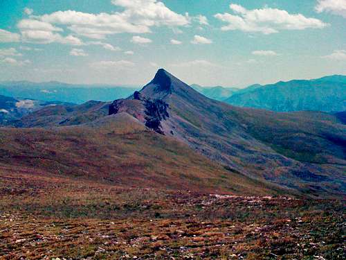
Unnamed 13158 Overview
In-depth Details
Here are more details:Elevation: 13,158 ft.
CO Peak Rank: 516
Range: San Juan
Counties: Hinsdale
Quadrangle: Uncompahgre Peak
Coordinates: 38.0542°N, -107.4381°W
Prominence: 378'
Saddle: 12,780 ft.
Proximate Parent: Uncompahgre Peak
Line Parent: Uncompahgre Peak
Isolation: 1.78
YDS Class Rating: 2
Getting There
 from the sign
From here continue up the trail like you would do for Uncompahgre. Once you get to the saddle marked by a sign, make a left and do the Class 2 accent of the peak. You either descend the opposite way and meet back up with the trailhead, or go back the way you came.
Red Tape
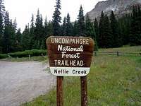 Nellie Creek
Here the info if you need to contact the forest service:
Grand Mesa, Uncompahgre and Gunnison National Forests
2250 Highway 50
Delta, CO 81416
(970) 874-6600
Camping
Camping is available all along the Lake City road including the Blue Mesa. It should not be difficult to find a suitable campsite anywhere near the area.External Links
Uncompahgre Wilderness Servicehttp://listsofjohn.com/PeakStats/Climbers.php?Id=645
Uncompahdre Wilderness