

-
 51466 Hits
-
 95.51% Score
-
 53 Votes
|
|
Mountain/Rock |
|---|---|
|
|
37.63232°N / 107.6466°W |
|
|
La Plata |
|
|
13972 ft / 4259 m |
|
|
Foreword
This page was completely erased, no information preserved, just photos and the climbing log. I hope that the new page will provide some useful information. I tried to give as detailed description as possible for the way up to Pigeon Peak using my own experience, Gerry Roach's 13ers guide book, and several trip reports. The peak is far away from civilization, and if one decide to hike in, expect about 28 miles round trip. Most people take the historic Durango Silverton train, which is pricey touristy attraction, but very scenic. Thank you Jamie for letting me work on this page.
Overview
Pigeon Peak is one of the most prominent mountains in the Needles area. It can be seen from the train as it proceeds along the Animas River from Durango towards Silverton. It rises nearly 6000 feet (1,829 meters) in under 2.5 miles (4 km) from Animas River. Its east face is a 800 feet (245 meter) cliff. It is located in Ruby Basin. Although not a fourteener as its neighbors in Chicago Basin (Eolus, Sunlight, and Windom Peak), it is still a very desirable peak to climb (really just a few feet shy of being a 14er).
Colorado Rank: 57 - this makes this peak very desirable for those trying to complete Centennials (= the highest 100 peaks in Colorado).
Best Time to Climb: July, August (snow does not melt until then), September.
Commonly done together with Turret Peak, which is easier to climb.
 Pigeon as seen from Turret Peak | 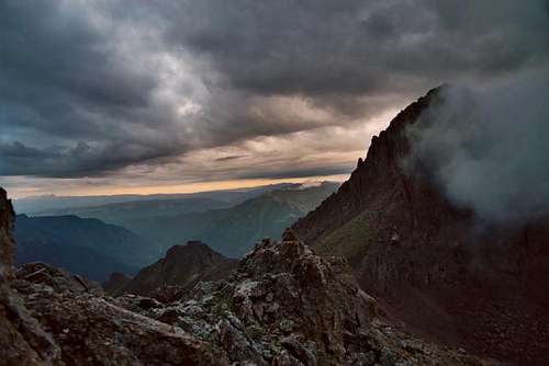 |
 Good morning below Pigeon Peak Good morning below Pigeon Peak | 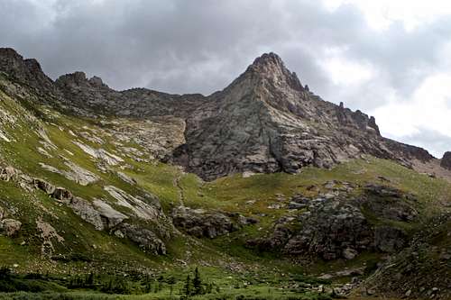 Pigeon Peak as seen from Camper's meadow at 11,740 feet Pigeon Peak as seen from Camper's meadow at 11,740 feet |
Cooper and Hubbard approached Pigeon from New York Basin. They were forced to abandon an attempt on the south face, next to the east-facing precipice. A rain shower and an uncomfortable smooth granite slope leading to a series of two or three steps of giant size forced them to retreat and try a gully on the south face further face. Two or three hundred feet below the summit, they were forced left (west) from their direct route to a notch on the southwest ridge from which they were able to reach the summit. After sunbathing there for two and half hours, their final deed was to look down the 900 foot (they thought it was 1500 foot) 85-degree east face - almost as spectacular as the east face of Longs.
Pigeon was next climbed by two well known pioneers in Colorado mountaineering history. In 1920, Albert R. Ellingwood and Barton Hoag reached the summit via "the large, prominent crack or couloir running up the south face". This was probably the same route taken by Cooper and Hubbard. Ellingwood and Hoag did not find any evidence of the 1908 ascent and in their report incorrectly assumed that they had made a first ascent. Ellingwood and Hoag also climbed neighboring Turret Peak and apparently did achieve a first ascent of it.
During the 1930s, Pigeon Peak received renewed interest. In August of 1935 H.L. McClintock, and Lewis Giesecke discovered what is now the standard route on Pigeon. From a camp in Ruby Basin above Ruby Lake, they walked up the grassy ledges on the west side of the north face. They made the first traverse of Pigeon by descending the southeast chimney.
List of peaks - Needle Mountains
Needle Mountains
The Needle Mountains are a vast climber's paradise. The fact that they are wild and rugged, with few roads and trails, has tended to make them a preserve for mountaineering. Only the Chicago Basin area saw any of the mining activity that swarmed over the rest of the San Juan in the last century. Except for ascents in Chicago Basin, and of Pigeon Peak, many of the first ascents of major peaks were not accomplished until Colorado Mountain Club and San Juan Mountaineer expeditions of the 1920s and 1930s. each decade since has seen new routes and climbs established, especially technical ones. There are still new routes to be explored on remote pinnacles and cold, dark north and east faces. In fact, there is a lifetime of climbing possibilities here. The Needles proper, as part of the large Weminuche Wilderness, lie between the Animas River to the west and Vallecito Creek to the east. In a general sense, the term Needle Mountains also encompasses the West Needle Mountains, west of the Animas River, and the Mount Oso group, to the east of Vallecito Creek.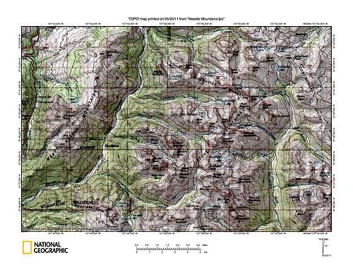 Needles TOPO Needles TOPO | 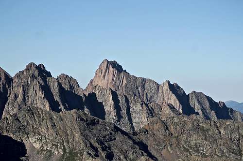 Pigeon Peak as seen from Trinity Peak. Pigeon Peak as seen from Trinity Peak. |
| Peak | Elevation | Access | Note |
| Mount Eolus | 14,083 feet | Needle Creek Access | fourteener |
| North Eolus | 14,039 feet | Needle Creek Access | not recognized as a separate fourteener; it is a short scramble from the low point between Eolus and North Eolus |
| Glacier Point | 13,704 feet | Needle Creek Access | route goes up its easy southeast ridge from lakes |
| Twin Thumbs | 13,420 feet | Needle Creek Access | the north Thumb is harder, rope is needed for short sections |
| Peak Eleven | 13,540 feet | Needle Creek Access | climb from the col between Twin Thumbs and Peak Eleven |
| Sunlight Peak | 14,059 feet | Needle Creek Access | fourteener |
| Sunlight Spire | 13,995 feet | Needle Creek Access | technical route rated 5.10 or easier if aided |
| Windom Peak | 14,082 feet | Needle Creek Access | fourteener |
| Jupiter Mountain | 13,830 feet | Needle Creek Access | several non-technical routes, or a very difficult Windom-Juniper ridge |
| Aztec Mountain | 13,310 feet | Needle Creek Access | can be climbed from Columbine Pass |
| Heisspitz | 13,262 feet | Noname Creek Access | 4th class scramble in a gully |
| Peak Four | 13,410 feet | Noname Creek Access | again 4th class scramble in a prominent gully |
| Peak Five and Peak Six | 13,283 ft and 13,705 ft | Noname Creek Access | both go from the 12,900 foot pass between them |
| Jagged Mountain | 13,824 feet | Noname Creek Access | is one of the more difficult and certainly one of the most rewarding climbs in the Needles |
| Gray Needle and Noname Needle | 13,430 ft and 13,620 ft | Noname Creek Access | interesting technical climbs |
| Leviathan Peak | 13,528 feet | Noname Creek Access | climbed by its southwest ridge, 3rd class scramble |
| Vallecito Mountain | 13,428 feet | Noname Creek Access | 3rd class scramble |
| Knife Point and Peak Ten | 13,265 ft and 13,400 ft | Noname Creek Access | are climbed from the col between them |
| Peak Twelve | 13,120 feet | Noname Creek Access | the route not very technical from pass south of the great wall of Monitor Peak |
| Monitor Peak | 13,695 feet | both Noname Creek and Ruby Creek Access | high east face has some of the longest rock climbs in San Juans |
| The Index | 13,400 feet | Ruby Creek Access | technical peak, route rated 5.7 |
| Animas Mountain | 13,786 feet | Ruby Creek Access | both technical and nontechnical routes |
| Peak Thirteen | 13,705 feet | Ruby Creek Access | both technical and scramble routes |
| Little Finger, Peak Sixteen, and Peak Fifteen | 13,200, 13,500, and 13,700 ft | Ruby Creek Access | all these peaks are technical and hard to get to |
| Pigeon Peak | 13,972 feet | Ruby Creek Access | little scramble, but also technical routes possible. |
| Turret Peak | 13,835 feet | Ruby Creek Access | hike up the talus from Pigeon-Turret saddle |
| Hope Mountain | 13,012 feet | Vallecito Creek Access | can be approached on an old road that crosses north of it going east to Hazel Lake |
| Grizzly Peak | 13,700 feet | Vallecito Creek Access | there are several Grizzly Peaks in Colorado, climb obvious ramp from Jupiter-Grizzly saddle |
| 13,554 feet | Vallecito Creek Access | usually done via ridge from Grizzly to McCauley | |
| Echo Mountain | 13,309 feet | Vallecito Creek Access | steep southwest slopes to the ridge west of the summit |
| Thunder Mountain | 13,108 feet | Vallecito Creek Access | has a 0.5 mile long, sheer cliff face that stops any attempts from the basin, better to climb from by its southeast ridge |
| Greylock Mountain | 13,575 feet | Vallecito Creek Access | is the only walk up in Grizzly Gulch Basin |
| Florida Mountain | 13,076 feet | Vallecito Creek Access | can be climbed most of the way by an old road that traverses south out of Vallecito Basin to Trimble Pass 12,840 |
| Bullion Mountain and Mount Valois | 13,182 ft and 13,185 ft | Vallecito Creek Access | 0.5 miles west of Trimble Pass, and Valois 0.5 miles southeast, are easy walk ups. |
| Emerson Mountain, Sheep Mountain, Amherst Mountain, Organ Mountain | all thirteeners | Vallecito Creek Access | to visit these thirteeners follow the trail south from Trimble Pass three miles to Florida River (good camping) |
| Peak Seven | 13,682 feet | Vallecito Creek Access | is the northernmost peak of Needles Proper, it is climbed by angling over to its easy north ridge |
How To Get There
 Across Animas River from Purgatory Flats
 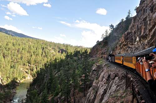 Durango Silverton trail operates daily during summer season, and provides access to peaks in Chicago Basin, Needle mountains, and Grenadiers.
 Once in Purgatory Flats, the trail turns south and follows the Cascade Creek drainage for a lift more than 3 miles down to the Animas River. (the trail never crosses Cascade Creek, I made that mistake on my first trip and tried to figure out a way across. There used to be an old bridge, which got washed away). The Purgatory trail is easy to follow, and you reach the Animas River at 7,700 feet, 3.7 miles from the TH. Cross the Animas river across a nice suspension pedestrian bridge, and then follow Animas River Trail for 5.1 miles to Needle Creek (turn off for Chicago basin) and another 0.9 miles to Needleton train station.
Do not go east up Needle Creek Trail but continue 0.7 miles north on the Animas River Trail to the East end of the footbridge over the Animas River at Needleton. The trail is very scenic, you can see the Durango Silverton train going by at some section. There are beautiful campsites along the trail. This approach is long, can be done in 1 day with a climb by hardcore people:) I used it to get Duchess in that way since pets are not allowed on train. I hike it twice now, and after my 2nd trip - I was thinking it is time to use the train.
Round trip distance: about 30 miles. This would be the same approach as for Chicago Basin, except for Ruby Basin you have to walk further north.
Needleton Trailhead via Ruby Creek or North Pigeon Creek - this is the stop of Durango Silverton train. You board your train in Durango. The train is rather expensive (I believe about 85$ per trip and they also charge 10$ per backpack), but very scenic, and you can drink beer en route. The Durango & Silverton Train operates from May 1 through October 30. During the peak summer season, four trains daily run on the line. Because of the numerous schedules, it is very important to make reservations in advance.
Get off at Needleton and cross the suspension bridge to the Animas River's east side.
Round trip distance: 12 miles
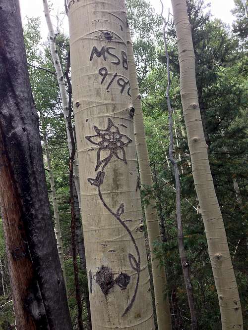 Columbine carved into a tree
 Pigeon and Turret Peaks as seen from Animas River Trail
There are several idyllic campsites here, and Gerry Roach calls it in his Colorado 13ers guidebook "Camper's Meadow". Walk north as the meadow narrows and enter the meadow's 100 yard long northern lobe. Gerry Roach is describing that there is a difficulty to find a trail past here, but the trail was very obvious in 2014. The trail will take you through the trees slightly uphill. This trail, the Ruby Creek Trail, did not connect to the Animas River Trail in the past. And again, as I mentioned I just followed a trail and it was all connected in 2014.
Leave the Animas River Trail and head north on a well-established trail which is now the Ruby Creek Trail. Hike 100 yards east through small trees to the southern edge of another idyllic meadow called "Upper Camper's Meadow". There is a nice established campsite, which I headed for. I lost a trail here. The trail should be taking a surprise turn to the south - again I did not see an established path, but walking across the meadow was easy. Look south from the established campsite (fire pit and huge logs to sit on). There are 2 blue ribbons hanging on a tree and a cairn marking the spot where the trail enters a forest. The trail is strong and easy to follow inside the forest.
Follow the Ruby Creek trail 0.3 miles NE to a rounded ridge at 9,200 feet. Continue 0.2 miles east on the trail as it enters the North Pigeon Creek drainage and climbs to North Pigeon Creek at 9,500 feet. Cross to North Pigeon Creek's north side and here the trail splits: the obvious main trail (per Gerry Roach obvious, to me a more obvious trail heads up) angles NW across the slope. This is not the shortest approach. This trail is a variation, which would bring you to Ruby Creek and Ruby Basin.
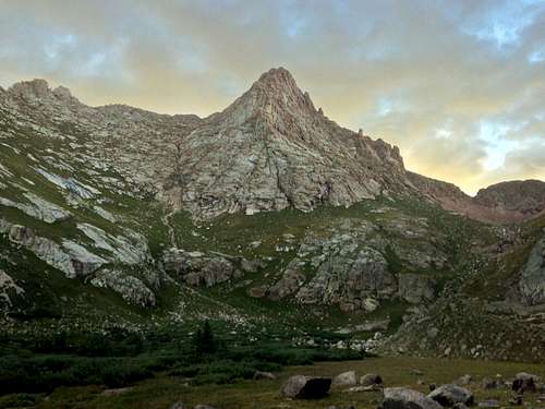
 Pigeon Peak in evening light as seen from Camper's meadow at 11,740 ft
From North Pigeon Creek crossing, climb 0.15 miles NE on the brutally steep Ruby Creek trail and follow it up a tiny ridge to yet another faint trail junction at 9,800 feet. The Ruby Creek approach and the North Pigeon Creek approach diverge at this junction (the Ruby Creek trail will leave the tiny ridge and traverses NE).
The junction is marked by an aspen tree with a columbine carved into it (the tree is about 7 meters from the junction, on Ruby Creek Trail). Trail to Ruby Creek turns north (left), and a small trail - Pigeon Creek Trail - continues straight up - east. This is the shortest approach for Pigeon - The North Pigeon Creek Trail. If Pigeon, or Pigeon and Turret are your only objectives, this is the best approach. If you plan to climb other peaks from Ruby Basin, then you should head for Ruby Creek Trail. There are no difficulties following the trail up to this point. The challenge is coming though.
The North Pigeon Creek approach leaves the Ruby Creek Trail at the 9,800 foot trail junction and continues up the tiny ridge. Climb 0.2 miles east up the tiny ridge, following a faint trail that fades to a cairned route that in turn fades into bushwhacking. At 10,200 feet, bushwhack 0.6 miles east-SE up and across steep slopes to 11,000 feet in the upper North Pigeon Creek drainage. Do not cross the creek.
The drainage gets easier here, and the worst part of the approach is over. I headed mostly east 85% of the time, and 15% of the time was traversing uphills southeast. It was a little interesting from the point that about for 3/4 hr I had no signs of trail (other than game trail), and cairns. Finally, I was able to catch a glimpse of Pigeon Peak through the trees. I knew I was heading in the right direction.
Climb 0.5 miles east-SE through open trees in the drainage to the west end of a large flat meadow at 11,740 feet. Stroll 0.1 miles east-SE into the idyllic meadow - great spot for camping. Pigeon Peak rises dramatically 0.7 miles to the east. Turret is hidden. This meadow is truly amazing - great views of Pigeon, well protected, and a small stream running through it. Mountain goats frequent the area. It is worth to come here… I would not recommend to plan the bushwhack section at night. I think seeing Pigeon Peak is a great orienting point and would imagine finding the meadow in the dark a much more difficult task.
Routes
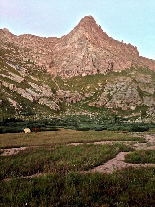 Camper's meadow below Pigeon Peak
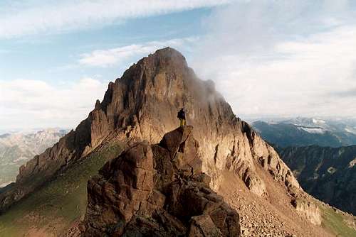
Description from Gerry Roach's Colorado 13ers: From 12,400 feet in the tiny basin, climb 0.3 mile east up the basin's steep grass slopes to 13,500 feet (class 2). Dodge small cliffs en route. Continue 0.1 miles east up steeper, rubble gullies to the northeastern base of the summit pyramid at 13,700 feet (class 2+). Climb 30 feet south up a blocky weakness in the summit pyramid (class 3). Climb 15 feet up a steep, chimney like slot (class 4). This is the route's crux. Continue 80 feet south up the weakness, then climb 100 feet east to the highest point (class 3). Pigeon's summit is the northern of two points and is capped by a cracked block.
North Pigeon Creek Approach - I believe that this approach is becoming lately more popular, and is shorter than Ruby Creek Approach. Just follow the direction as described above for the North Pigeon Creek trail and camp at a small meadow at 11,740 feet. The route is very obvious from here although appears steep. I found no class 4 moves, and I am not sure if I even encountered class 3 moves. My rating would be class 2+. You ascend the grassy slopes while heaving the main Pigeon's summit slightly to the east. Once you get into the rock, section, you fill find cairns. Follow the well cairned route zigzagging over blocks until the summit. The route avoided major technical difficulties and the chimney described in Gerry Roach's Colorado 13ers book will be avoided. (I actually never found that chimney). I was honestly surprised how easy it felt.
Most of the route goes on steep grassy slopes and then high up on stable blocks zigzagging in between. It is a very pleasant peak from the point that it avoids much of the infamous San Juan loose scree peaks, and one of those I would enjoy summiting it again.
North Face: There is a much more direct route that lies west of the first large gray rock ridge that runs from the north face of Pigeon. It climbs grassy ledges and continues up the northwest ridge. Under ideal conditions and excellent route finding it is not too difficult, but it is easy to get into technical trouble here, and a rope and protection ought to along for those anxious moments. To gain the route, contour west below the north face to climb the "grassy ledges" described by Ormes which lead to the northwest ridge.
The north face route is by no means the walk up that some have characterized it to be. The right route is hard to find and in bad weather can be difficult. It is also possible to take a more direct route on the north face by several technical variations on the east side of the north face, which are about 5.5 in difficulty and hard to protect. About the only way to protect the eastern routes are with knife blade and angle pitons. The rock is too crumbly to trust other protection.
East Face: 10 pitch route (five involving 5.9 climbing) was noted in the January/February 1978 issue of Climbing. The route follows a prominent dihedral crack system on the right (north) side of the face. One pendulum was used to switch cracks, but otherwise the route was all free. The rock is reported to have been extremely rotten.
Southeast Chimney: The common descent off Pigeon, particularly if the next objective is Turret (Colorado rank # 89), is the southeast chimney. To find it from the top, use a couloir which descends south from west of the summit and splits about 400 feet down, then rap the chimney to the saddle. Two double rope rappels are required. The first from a chockstone 30 feet below the start (many old slings around it - examine the condition of the slings), the second 120 feet long, from hardware, 80 feet lower. The second rappel is 120 feet long. The ledge at the start of 2nd rappel holds comfortably only 2 people. And you can't see the rappel anchors from the top of the first rappel. This grungy chimney would not be a good ascent route.
SUMMIT VIEWS FROM PIGEON PEAK
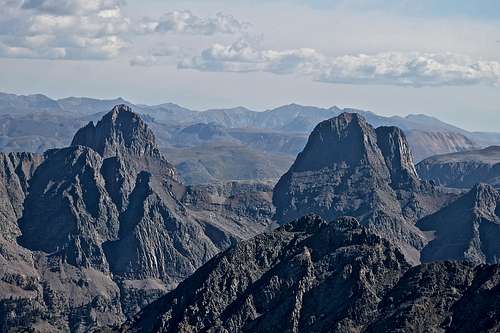 Vestal and Arrow Peaks Vestal and Arrow Peaks | 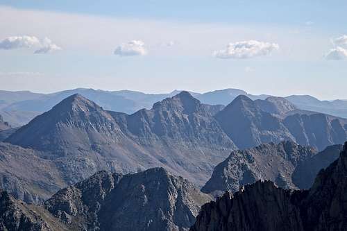 Trinity Peaks Trinity Peaks | 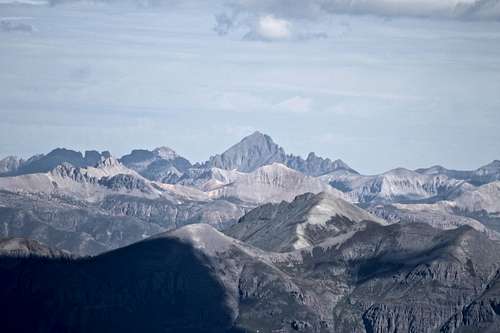 Mt. Sneffels Mt. Sneffels |
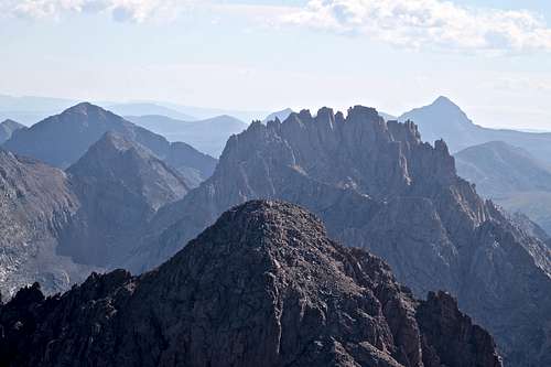 Jagged Mountain Jagged Mountain | 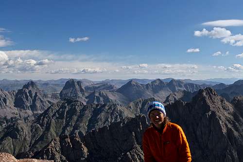 Pigon Peak Summit Pigon Peak Summit | 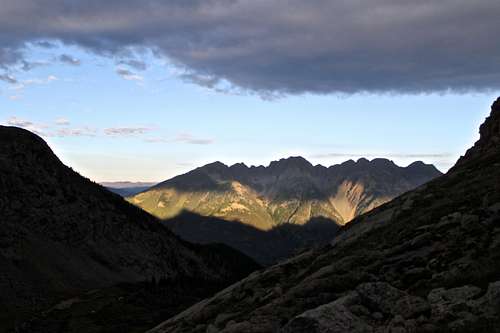 West Needle Mountains - Sunrise West Needle Mountains - Sunrise |
External Links
- Pigeon Peak on Mountain Project
- Pigeon Peak on 13ers.com
- Trip report on 14ers.com
- Detailed description of the approach, routes - Gerry Roach "Colorado's Thirteeners From Hikes to Climbs"
- Lists of John - Pigeon Peak
- Durango Silverton Train
- Purgatory Trail (511)
Brian Kalet - Dec 11, 2013 3:05 pm - Hasn't voted
Needle Mountains LinksLooks like there are SP pages for Leviathan Peak, Peak Fifteen & Knife Point in case you want to add links to your Needle Mountains list...
Liba Kopeckova - Dec 11, 2013 9:37 pm - Voted 10/10
Re: Needle Mountains LinksAdded. Thanks.