

Viewing: 1-4 of 4

EricChu - Jan 21, 2010 7:59 pm - Voted 10/10
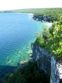
Beautiful album!The color of the water in many of these pictures is just a dream!!

ArankaP - Jan 25, 2010 11:16 am - Hasn't voted
Re: Beautiful album!One of the places I like to visit every year even just for few days.

climbncookie - Jan 22, 2010 12:02 pm - Hasn't voted
Great Shots!Great collection of photos. I love the water out there. You've inspired me to get up my photo's from my trip out there this past December.
ArankaP - Jan 25, 2010 11:23 am - Hasn't voted
Re: Great Shots!I was skiing in Blue Mountains this weekend hoping to make it there for a day trip. It begun to rain Sunday afternoon so I drove back home.
Never been there in winter. Looking forward to explore it soon.
Thank you for stopping by.
Aranka
Viewing: 1-4 of 4
Comments
Post a Comment