
|
|
Area/Range |
|---|---|
|
|
Hiking, Toprope, Bouldering, Ice Climbing, Skiing |
|
|
Spring, Summer, Fall, Winter |
|
|
577 ft / 176 m |
|
|
Lake Huron
Lake Huron, 59 600 km2, elev 176 m, 332 km long, 295 km wide, max depth 229 m; total shoreline length, including islands, 6159 km. Lake Huron is the second largest of the Great Lakes and fifth-largest lake in the world. Samuel de Champlain visited Georgian Bay and Lake Huron with the French scout Étienne BRULÉ and a fleet of Indian canoes in 1615.
Four interconnected bodies of water - the main lake, Saginaw Bay, the North Channel and Georgian Bay - form the lake. Major inflows are the Straits of Mackinac and the St Marys, Mississagi, Saginaw, French and Spanish Rivers. Lake Huron discharges into Lake Erie through the St Clair R., Lake St Clair and the Detroit River. The Straits of Mackinac between Lakes Huron and Michigan are spanned by the Mackinac Bridge which upon completion in 1957 was the longest suspension bridge in the world. It remains one of the longest in the world today.

Georgian Bay
Air masses from the Arctic, Pacific and Atlantic oceans and the Gulf of Mexico converge on the lake, which therefore experiences 4 distinct seasonal patterns and extremes of weather conditions. Its basin is composed of the Precambrian Shield and the Phanerozoic rocks and it was formed during the most recent ice age, with its present form developing only 2000-3000 years ago. The Canadian side of the basin is primarily covered with mixed forest consisting of pine, hemlock, birch, maple, oak, beech, walnut and hickory. Some of these trees are 750 years old.
The northern basin is an isolated, underdeveloped hinterland, with a few settlements engaged in the exploitation of forest and mineral resources. Southern settlement is founded on lumbering and agriculture. Important industries include mining, pulp and paper, food processing, chemical production, transport equipment and metal fabricating. Sudbury, the center of the mining and smelting industry is the only major urban center in the area. One of the world's largest nuclear power plants is located at Douglas Point on the Bruce Peninsula. The lake supports commercial fishing (whitefish, perch, walleye, chub, carp) and sportfishing (bass, perch, walleye, pike, rainbow trout). The Canadian side of Lake Huron is renowned for the beauty of its scenery. The North Channel and Georgian Excellent beaches extend from the Bruce Peninsula to Sarnia. The basin offers wide, unpolluted waters for swimming, boating, cottaging and camping.
Georgian Bay

Emmet Lake trail

Flowerpot Island
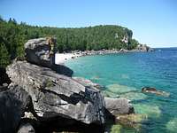
The fresh waters of Georgian Bay - Lake Huron, Ontario provide some of the finest beaches in North America. Beaches and several areas along Georgian Bay are having some of the cleanest and best quality water in the world.
Backcountry Camping: There are wilderness sites in the park along the Bruce Trail following the Escarpment at High Dump and Stormhaven. The sites are accessible to backpackers along a rather rugged trail. There are 18 sites in total and you must pre-register to obtain one. Reservations will prevent you from being disappointed, so contact the park early. There is also a camping area on Flowerpot Island in Fathom Five National Marine Park located just off Tobermory. There are six campsites that are available only on a first-come basis. Advanced kayakers can paddle to the sites after picking up permits. Bad weather may hold you down for days here, so be sure to bring extra supplies.
The Bruce Peninsula National Park of Canada
The Park is situated on the northern tip of the Bruce Peninsula, between Georgian Bay and Lake Huron. The beautiful park, with a size of 155 square kilometers, at the tip of the Niagara Escarpment, consists of limestone cliffs, caves and underground streams, and ancient forests with some of the oldest trees in Canada. The Bruce Peninsula National Park is comprised of an incredible array of habitats from rare alvars to dense forests and clean lakes. Together these form a greater ecosystem - the largest remaining chunk of natural habitat in southern Ontario

Indian Head Cove
History of the Bruce Peninsula National Park
In 1987 the Park came into existence. The federal and provincial governments established an agreement – which was not greeted with open arms by some of the residents in the Northern Bruce Peninsula. Today – both local residents and visitors have increasingly embraced the park. A park survey of Bruce County residents found, for example, that 73% of respondents felt that the most important role of the park was protecting the natural environment. Sixty percent of the local residents surveyed had visited the park in the previous year. Meanwhile, it is estimated that close to 10 million people now live within a four-hour drive of the park.
The final park boundaries encompass an area of approximately 156 square kilometers, with significant private land holdings within these boundaries (covering about one-fifth of the park’s area).

Grotto
Hiking
There are hikes for all levels, from the beginner to the advanced, from a leisurely stroll along a boardwalk or rail trail to challenging multi-day hikes.

Flowerpot Island
In the Cyprus Lake area, the trails are accessible from the Head of Trails area. Except for the Cyprus Lake trail, all of the trails lead to Georgian Bay and connect to the Bruce Trail. Head north along the Bruce and have a picnic at the Grotto at Indian Head Cove or south to the campsite at Halfway Dump.
Cyprus Lake Trail is an easy and very pleasant 5km trail hike that loops around the lake - access from the Head of Trails.
The Horse Lake Trail is an easy 1km to the bay along the shore of Horse Lake - access from the Head of Trails.
The Georgian Bay - Marr Lake Trail reaches out to the bay, then loops back to the head of trails. As the name implies, the trail passes by Marr Lake - access from the Head of Trails.
The Grotto has a slightly difficult climb down. Once in the Grotto you will see a fantastic underwater cave that goes next to Georgian Bay. On many weekends you will see scuba divers swimming through it. A very, very good swimmer can make it through. If you go from the inside out to Georgian Bay there will be light to guide you. For the beginners on the way down into the Grotto, there is an easier climb through the hole. It can be found close to the wooden steps.
Singing Sands Self Guided Nature Walk is 1.5km and an easy walk. This is an area with a very interesting ecological history and is well known for its orchids. The trail is on the west side of the Peninsula in a separate isolated section of the park across the highway from George Lake.

Flowerpot Island
Halfway Log Dump is accessible from Emmett Lake via the gated road. This 3km hike will take you to one of the most spectacular areas of the Escarpment that lies within the park. This trail will also bring you to the area for bouldering and climbing.

Lion's Head Trail
On Flowerpot Island you'll find the Loop Trail which passes the flowerpot sea stacks and allows access to the lighthouse. There's also an out-and-back in the form of the Marl Trail which takes you to the western side of the island.
The Island is located off the tip of the peninsula from Tobermory and is accessible by boat, or for expert paddlers by kayak.
Lion's Head Trail
Location: Getting to the Trailhead: Once in the town of Lion's Head, hang a right on Moore Street and proceed for about two kilometers, until you see the white Bruce Trail blazes on the right. There is some parking at the trailhead on the roadside, but if it is too busy, park in the schoolyard about one kilometer back and walk to the trailhead.

Bruce Trail
Camping for Cyprus Lake Trail, The Horse Lake Trail and The Georgian Bay trail, The Grotto and Marr Lake Trail: all these trails can be reached by foot from Cyprus Lake Campground

Climbing
Climbing, ice climbing and bouldering in this area is considered one of the best in Ontario. We hiked and bouldered along the shore at the Georgian Bay in the summer only.
Nice area to boulder is at:
Halfway Log Dump also marked as Emmett Lake Rd.
Direction to Halfway Log Dump:
See album Bouldering at Georgian Bay
For more climbing information: lions-head-peninsula
Extreme Adventures
Ontario Access Coalition
Bruce Trail

Georgian Bay
The Bruce Trail is a continuous, 850 km footpath on the Niagara

Lions Head Trail
Escarpment connecting Queenstone, near Niagara Falls, with the village of Tobermory in the Bruce Peninsula, Ontario. The trail follows the escarpment cliff through the fruit lands of Niagara and the city of Hamilton, across the Dundas Valley, north through the Caledon Hills to the Blue Mountains, then northwest across the Beaver Valley to Owen Sound and onward, seldom out of sight of Lake Huron's Georgian Bay, to Tobermory.
The sparkling blue waters of Lake Huron and Georgian Bay splash upon the sandy beaches and rocky shorelines of Grey, Bruce and Huron counties, offering breathtaking sunsets. The Niagara Escarpment rises up from the rolling farmlands, offering a backdrop for picturesque countryside, inland lakes, colorful towns and hamlets. Hiking the Bruce Trail along the limestone cliffs offers glimpses of birds and wildlife, ferns, orchids and ancient dwarf cedar trees, for which this area is renowned.
Camping on Bruce trail area of the peninsula see Backcountry Camping in Georgian Bay section
Bruce Trail
Bruce Trail Map
Calendar events
Southern Georgian Bay

Southern Georgian Bay features more than 30,000 islands. Georgian Bay Islands National Park's beauty is serene. Windswept pines, majestic towering cliffs, endless beaches and clear blue water all create a one of a kind destination. Discover the rich marine heritage and lighthouses that dot the coastline, relax on a beach, explore the great outdoors or cruise the best roads on your motorcycle. The Georgian Bay Coastal Route presents the best that Georgian Bay has to offer.
Georgian Bay Tourism Getaways - Autumn visitors may want to visit one of Ontario's finest parks for fall hiking and biking, Awenda Provincial Park just outside of Penetanguishene, or Georgian Bay Islands National Park. Walk and explore the many beaches in the Southern Georgian Bay area. Take a romantic fall color cruise and savor the history that lived along the Southern Georgian Bay sites of Saint-Marie among the Hurons, and the Huron-Ouendat Village in Midland.
Protecting one of Canada's national treasures for your enjoyment: from Honey Harbour to Twelve Mile Bay in southern Georgian Bay you will discover spectacular landscapes, time-worn rock faces, diverse habitats and the rugged beauty of the Canadian Shield. These magnificent islands are accessible by boat only. The largest island, Beausoleil, offers tent camping, overnight and day docking, heritage education programs and hiking trails.
Other parks along the Georgian Bay shoreline
Killbear Provincial Park

This Georgian Bay peninsula is a water lover's paradise for swimming and sailing, fishing and boating. Camp by a sandy beach, on a rocky shore or under the trees. Hike to lookouts for views of Parry Sound, that lonely white pine on a windswept rock or one of Georgian Bay's spectacular sunsets. Killbear Provincial Park
Killarney Provincial Park
Considered one of Ontario Parks' crown jewels, this majestic, mountainous wilderness of sapphire lakes and jack pine ridges so captivated artists - including The Group of Seven's A.Y. Jackson - that they persuaded the Ontario government to make it a park. Once higher than the Rocky Mountains, La Cloche's white quartzite cliffs gleam like snowy peaks from afar. Where paddlers, hikers, skiers and snowshoers now journey through in this craggy, imposing landscape, there is evidence that others passed thousands of years before. Killarney Provincial Park
Wasaga Beach
This 14-kilometer safe sandy beach, the world’s longest freshwater beach on Georgian Bay attracts thousands every summer. So do the park's other features: hiking and cross-country ski trails through sand dunes or pine-oak forests; a historic site that tells Wasaga's colourful naval history; jazz concerts and military re-enactments. Wasaga Beach
The Massasauga
Stretching along the coast of Georgian Bay from Parry Sound to the Moon River, this park takes in hundreds of windswept islands as well as inland forests and lakes. Accessible only by water, it is a protected sanctuary for the Massasauga rattlesnake and home to prairie warblers, five-line skink, hybrid toads and map turtles. Moor in a quiet cove, fish for muskie and bass, camp by the bay or paddle to inland lake sites. Be sure to visit Calhoun Lodge for a glimpse of 1930s cottage life.
The Massasauga
Ipperwash Provincial Park

SOUTHERN LAKE HURON, Kettle Point next to Ipperwash Provincial Park

Ipperwash Provincial Park
The Stoney Point First Nation claims the park contains a native burial ground. The status of the park, along with the adjacent military facility at the former Camp Ipperwash led to a violent protest in September 1995 that resulted in the death of Dudley George. The park remains closed to this day due to the land dispute; it is unclear when, or if, it will reopen to the public.
Mackinaw City and St. Ignace

St. Ignace
Mackinaw City is at the southern end of the 5-mile long Mackinac Bridge, which allows travel to the Upper Peninsula of Michigan. Mackinaw City, along with St. Ignace across the straits, is a base for ferries to Mackinac Island.
According to AAA's 2009 TripTik requests, Mackinaw City is the most popular tourist city in the state of Michigan. Local attractions include Fort Michilimackinac, Mill Creek, the Old Mackinac Point Light, and the McGulpin Point Light
Mackinac Island


Arch Rock
Travel to Mackinac Island is by boat, ferryboat, or by small plane. Ferryboats depart from Mackinaw City in the Lower Peninsula and St. Ignace in the Upper Peninsula every half hour during the summer season. Boats have an enclosed lower deck for a comfortable trip of about 20 minutes, offering visitors the opportunity to stay on the Island for a short or longer visit. You may spend a few days enjoying the outstanding beauty of Mackinac Island.
The majority of Mackinac Island is preserved as Mackinac Island State Park, undeveloped wilderness with 140 miles of trails and footpaths for biking, hiking, and horseback riding. There is an 8-mile perimeter road around the island, ideal for a carriage tour or a bike ride.

British Landing Nature Center
Stop at British Landing Nature Center where the British landed during the War of 1812. As you travel the Island, don't forget to view Arch Rock, 150' above the eastern shore; lakeside caves; Sugar Loaf, the large inland slab of limestone; unique rock formations; wildflowers; and woodlands.
For visitor information and a free visitors guide:
contact the Mackinac Island Tourism Bureau
Box 451 Mackinac Island, MI 49757
Telephone: 877.847.0080
Castle Rock

Castle Rock
Castle Rock is a geological limestone stack and tourist attraction located 3 miles (5 km) north of St. Ignace, Michigan on Interstate 75 in Michigan's Upper Peninsula.
Castle Rock, which rises 195.8 feet (59 m) above the waters of nearby Lake Huron, was created by erosion of surrounding land. After the Wisconsinan Glaciation, post-glacial Lake Algonquin formed. The Ice Age melt-off caused the waters of Lake Algonquin to be much higher than the water level of Lake Huron is today. Over time, the declining water eroded much of the land. Castle Rock, which resisted this erosion, is made of limestone breccia.
From Wikipedia, the free encyclopedia
For more information
Wikipedia
Georgian Bay
Spring Flowers & Hiking Bruce Peninsula
Bruce Trail info
Bruce Peninsula National Park of Canada