

Comments
No comments posted yet.
|
|
Trip Report |
|---|---|
|
|
Jan 2, 2012 |
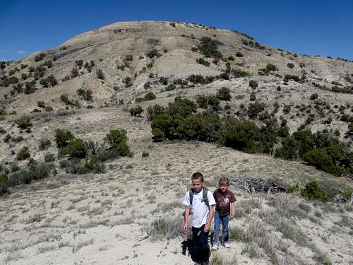
This is just a simple log to keep track of our 2012 trips.
See the 2011 Trip Log for 2011.
See the 2010 Trip Log for 2010.
See the 2009 Trip Log for 2009.
See also the 2008 Trip Log for 2008.
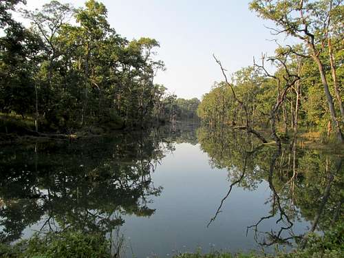
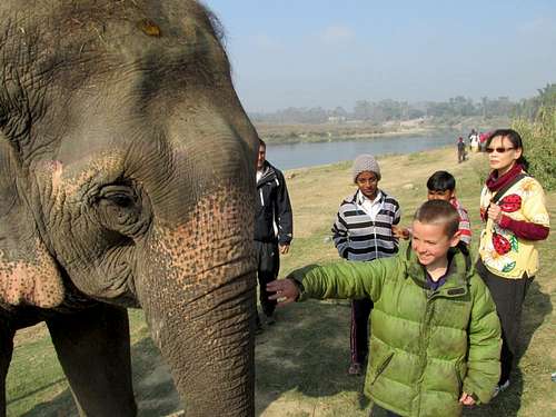
December 31: Chitwan Trek (Nepal)
In the morning we took a nice elephant ride to look for rhinos, tigers (sightings are rare), birds, spotted deer, barking deer, etc, but we didn't see any rhinos (last time I was here 11 years ago, we saw several). We did see lots of deer and birds.
We then took a canoe ride down the river and saw many marsh mugger crocodiles (including several big ones) and birds. It was then elephant bathing.
We then did a hike through the jungle to look for animals. We saw more deer, birds, a crocodile, and a monkey, but unfortunately still no rhinos. After that was a visit to the elephant breeding center.
December 30: River Trail/Chitwan (Nepal)
We took a hike along the river to look for wildlife. We did see one rhino from quite a distance, but no rhinos up close. We saw a lot of bird life though.
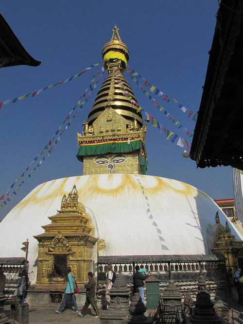
December 29: Swayambhunath (Nepal)
After flying back to Lukla in the morning, we walked most of the way to Swayambhunath, known as the "Monkey Temple" and set on top of a hike hill in Kathmandu. We did take a wrong turn and flagged down a taxi for a short ride, just so we'd know how to get there.
After arriving at the base, we climbed the stairs up the big hill and spent some time around the temple admiring all of the architecture (and the monkeys of course) before walking most of the way back to Thamel.
December 28: Phakding to Lukla (Nepal)
Kessler got sick last night, but we were still glad that it happened at the very end of the trek rather than at the beginning or middle. Other than that, the walk back to Lukla from Phakding was rather uneventful.
We had beautiful clear skies and a morning temperature of 33F (1C) which was a welcome relief from the cold.
In the afternoon we bade farewell to our porters and gave them their tips and also let them keep the backpacks they had been carrying. They were very happy to receive them.
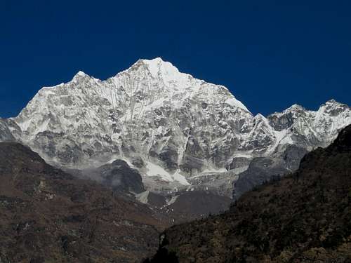
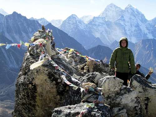
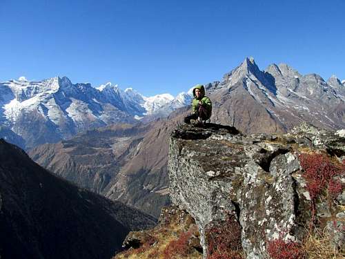
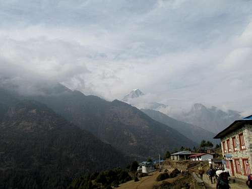
December 27: Chhorkung Ri (Nepal)
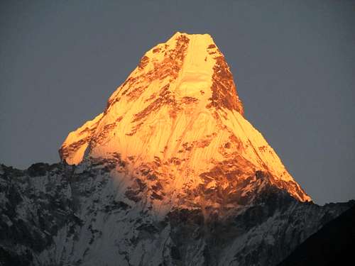
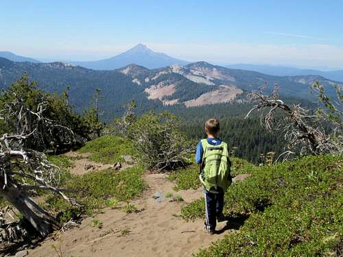
We had to get just one more small peak above Namche Bazaar in before heading back down, so we decided to climb Chhorkung Ri before heading back down. We also descended to the Sagarmatha Park Headquarters and Museum and got several last photos of Everest and the surrounding peaks before our descent.
The last view of Everest, Lhotse and Ama Dablam was actually below Namche Bazaar along the trail (we missed the views on the way up do to clouds). After Bengkar, there are no more really big peaks visible, but the walk is still very beautiful with the forest, river, and views of the "small" peaks.
December 26: Jaro Ri (Nepal)
Today we walked from Potorse Tenga to Namche Bazaar. It was another sunny day and 12F (-11C). It was an up and down route all the way and we decided to go through Khumjung and Khunde visiting the Hillary School, Gompa, and hospital.
We also decided to climb Jaro Ri, the highest point on the south side of these two towns. It was actually harder than expected and was a stiff rock scramble with some bushwhacking. The views were awesome though and we saw some colorful pheasants.
After climbing the peak and admiring the views, we descended to the Syangboche Airstrip and then down to Namche.
December 25: Pheriche to Phortse Tenga (Nepal)
It was 2F (-17C) in the morning which was colder than I expected since now we were at the comparatively low elevation of 14,042 feet/4280 meters. I didn’t sleep well for the first half of the night because of all the barking dogs at Periche (they were not a problem in the other places we stayed).
Before leaving Periche, we visited the Everest memorial for all the climbers that have been killed on Everest. Along the way to Phortse Tenga, we saw two very colorful birds that looked similar to peacocks. We also saw a mountain goat.
About half way along the trail, there was someone dressed as Santa Clause and handing out candy canes to all the passing trekkers! The children in Phortse were very friendly and came out to greet us as we walked past. Other than that, it was a fairly uneventful day.
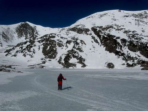
December 24: Kala Pattar (Nepal)
Today was quite eventful and in some ways a little scary.
Because of the cold, I didn’t want to get up early and thought that we should wait until later for warmer weather and better lighting conditions for photos.
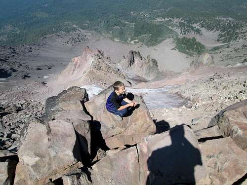
All went well except for one scary moment when the Sherpa got altitude sickness. When we climbed Kala Pattar, it was -19F/-18C and fairly windy. I wanted to sleep in until it got warmer, but the Sherpa wanted to climb early in the morning. Because it was so cold and the sunlight was beckoning up higher, Kessler and I hurried very quickly 16,995 feet/5180 meters to 18,373 feet/5600 meters making the 1400 feet/420 meter climb in an hour, which is much faster than normal. Since we had no idea that the Sherpa was feeling altitude sick, we climbed both little peaks around Kala Pattar.
The Sherpa got sick trying to keep up, but we didn't know that he was sick until we got down and he couldn't walk well. He wouldn't admit that he was altitude sick, but we and others could tell. It was apparently a matter of pride that he couldn't keep up with Kessler and the Sherpa people have a hard time admitting to altitude sickness, so we had no idea (he was apparently a well known climbing Sherpa whom had been to Everest several times as a porter, which made it harder to admit sickness).
We were supposed to head back to Lobuche and climb the Lobuche Pinnacles today, and cross the Cho La the next day, but since the Sherpa got sick we descended quickly to Periche and divided the load between the other porter and myself.
We got the Sherpa back down to a lower elevation and after taking Diamox, he was OK again and was back to normal and going strong. We were very glad everything worked out well. I would have felt really guilty if anything had went wrong. The altitude sickness never was life threatening, but it was scary since it was very difficult to try and talk the Sherpa into descending.
Other than that scary incident everything ran perfectly. It was cold, but we had clear and cold skies the whole time. It was so spectacular and I took many photos so far. So far, the people in the mountains were really nice and the mountains were great.
Focusing on the good part, Kessler beat his altitude record set on Chhukhung Ri, but only barely. The Sherpa felt bad that we had to change our plans, but we assured him that we were fine with the change of plans and wouldn’t mention him by name. We gave him part of his tip early to show that we weren’t upset at all.
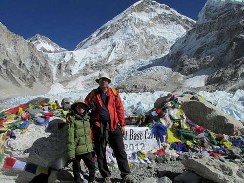
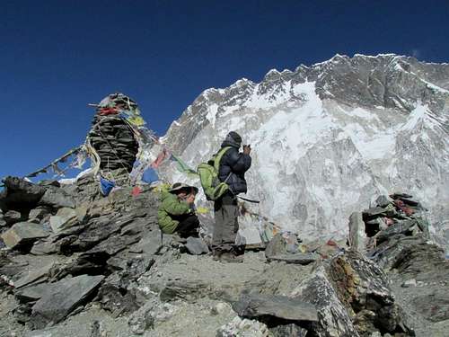
December 23: Everest Basecamp (Nepal)
The wind really blew hard all night and it sounded like the roof was going to blow off the tea house. By morning it was 2F (17C) inside our room. I didn’t take an outside temperature until the sun was fairly high in the sky and even then it was 0F (-18C).
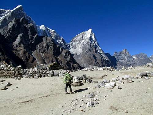
After breakfast, we walked from Lobuche to Gorak Shep, which at 16,995 feet/5180 meters, is the highest settlement in the world. After lunch we headed for the Everest Basecamp. It actually took much less time than it was supposed to (according to the guidebooks) and we made it in 1 hour and 25 minutes. It felt good to be walking so fast since it meant that we were acclimatized.
The mountains were certainly spectacular here and the walk was well worth it. We say one fur ball pika long the way. At first, I was confused as to where the Khumbu Icefall spills out of the Western Cwm because it is so hidden until you are there. The basecamp was actually much cleaner than I expected it to be and there was actually hardly any trash other than a few left over posters and old prayer flags.
Kessler wanted to spend a lot of time poking around and playing at basecamp. We spent 1.5 hours there before I talked him into going back down.
At Gorak Shep we had a nice spaghetti dinner before heading off to bed.
December 22: Chhukhung to Lobuche (Nepal)
We awoke to 7F (-14C) this morning, but there was only a light breeze. We did the long hike from Chhukhung to Lobuche under clear skies and made excellent time. We passed everyone else on the trail, even though we walked farther than most (we were well acclimatized now because we had climbed several peaks by now). It took us one hour Chhukhung to Dingboche, another 1 hour 20 minutes to Dhugla, and another 1 hour 15 minutes to Lobuche.
The mountains were beautiful, but the afternoon was quite windy. Along the way, we visited various memorials to the climbers that have been killed on Everest and other nearby mountains.
At Lobuche, Kessler and I took a very cold bath just below the spring. Most of the water was frozen, but we had been walking and climbing several days without a bath or shower, so we took a bath in the freezing ice water anyway. Kessler only went up to his ankles in the water and washed from there.
After washing some of our clothes in a bucket, we headed for the Pyramid, a high altitude research station. The wind really picked up and it became very cold.
December 21: Chhukung Ri (Nepal)
It was extremely windy last night, but we awoke to only a stiff breeze. The climb of Chhukhung Ri was on!
After a nice breakfast of pancakes and porridge, we headed up the mountain. We made good progress and admired the yaks, including a huge one that was the biggest that I ever seen. He must have been the alpha male.
We continued up the steep track to the saddle between the two Chhukhung Ri peaks. We decided to climb the lower peak (17,772 feet/5417 meters) first. It was very windy and cold on top, but the views were spectacular. After climbing the lower peak, we descended to the saddle and climbed the higher peak (18,238 feet/5559 meters). It had some tricky scrambling and the climb took much longer than it looked.
The exposed scrambling was similar to Pyramid Peak in Colorado and Kessler got really tired just before the top. It was the highest peak that he had ever climbed.
The views from the higher peak were even more spectacular than the first peak, but it was very windy and cold so we didn’t spend that much time on the summit.
We were right there in front of the huge faces of Nuptse and Lhotse and could look down on all the glaciers. The views of Makalu were spectacular as well. It was the grandest mountain scene that I have ever laid eyes on.
After enjoying the summit, it was a long hike back to Chhukhung. It was a very rewarding climb, but the second peak was little harder than expected and due to the long and tiring day before (Dingboche to Island Peak Basecamp and back to Chhukhung) and the extreme winds and cold, it wasn’t that easy of a day.
December 20: Dingboche to Chhukhung/Island Peak Basecamp (Nepal)
It was a beautiful, but difficult day. We walked all the way from Dingboche to Island Peak Basecamp and all the way back to Chhukhung. We hoped that we didn’t wear ourselves out too much for the next day’s climb.
It was really windy and cold all day and there were lenticular clouds over the peaks, especially Lhotse. It gradually got clearer in the afternoon, but the wind was really cold and brutal. The route was very long as well and Island Peak Basecamp is at 16,900 feet/5151 meters. We found that Basecamp was abandoned. The yaks up here are really hardy creatures because they didn't seem to mind the wind and cold.
The walk was really spectacular, but we were really glad to make it back to Chhukhung. At 15,600 feet/4755 meters, this was our highest sleeping altitude in quite a while.
December 19: Nangkartshang Peak (Nepal)
Today was another spectacular one and we climbed Nangkartshang Peak. At 16,676 feet/5083 meters, this would be the highest Kessler and I had been for a few years (November 2007). We awoke to 19.8F (-7C) and again, it was sunny, but very windy and dusty.
This climb was a good one and was fairly straightforward. It was a much easier ascent than Hamugon which we climbed a few days earlier.
The views were the most spectacular yet and we got some unusual views of Cho Oyu. Makalu was really spectacular as well, as were our different angle views of Ama Dablam, Cholatse, and Toboche.
After climbing the peak we returned to Dingboche. More people showed up at the lodge and the porters were all gambling. They taught Kessler how to play tigers and goats, a board game.
December 18: Ama Dablam Lakes (Nepal)
It was yet another gorgeous day. It was very windy and sunny except for a few high cirrus clouds (which may indicate an approaching storm).
We hiked up to the Ama Dablam Lakes and to a minor peak. The views of the frozen lakes and surrounding peaks were really spectacular. We were right up near the glaciers and we could see many peaks, including our first views of Makalu.
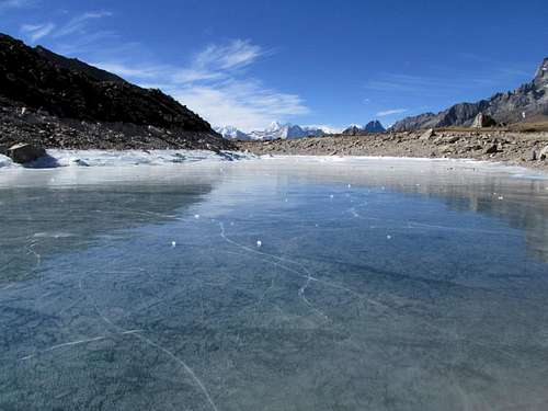
Kessler loved the frozen lakes and we played for many hours throwing ice blocks across the lakes. The lakes were cracking and groaning despite the 12”+ (30+ cm) ice thickness. On the way down we passed some slower groups.
We were hoping for good weather for the next few days, but were a little worried about an approaching storm. I also had my first minor stomach trouble, but luckily it was very minor.
December 17: Pangboche to Dingboche (Nepal)
It was yet another beautiful and clear day. We awoke to 21F (-6C) and hiked from Pangboche to Dingboche. The mountains are very beautiful, but prices kept rising as we went higher.
I almost got shoved off the mountain by an angry yak! Usually yaks appear to be gentle creatures, but this was must have been in a foul mood because it shoved me right off the trail as it passed.
Peak 32, Ama Dablam, Lhotse, Island Peak, etc., all put on a good show for us in the afternoon and evening.
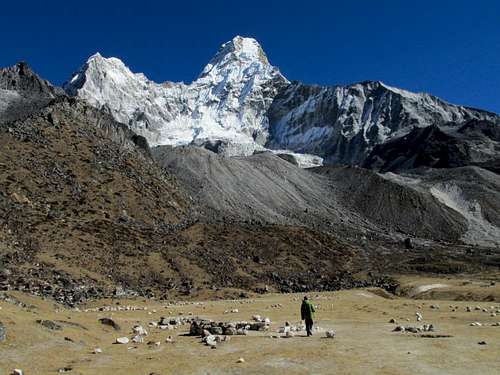
December 16: Ama Dablam Basecamp/un-named peak (Nepal)
Today was another beautiful and clear day. We awoke to 22F (-6C) and walked to the Ama Dablam Basecamp and climbed a minor peak near Mingmo. The trail was moderately steep at first, but not bad at all. All along the way we got some really spectacular views of the mountains. We got really close to Ama Dablam and the glaciers and we explored around the basecamp before heading back down. We saw some more pheasants.
The evening sunset was another really spectacular one!
December 15: Hamugon [Peak] (Nepal)
Today was another great day. We awoke to 23F (-5C) and climbed Hamugon, the peak above Tengboche, which was much more difficult than expected.
The first 1/3 of the climb was easy and with spectacular views. We saw many pheasants along the way. On the way up we witnessed a helicopter landing below in Tengboche. We theorized that it was the sick person from Singapore we met the day before (this assumption was correct as we were to find out when getting back to Tengboche)
The next 1/3 of the climb up Hamugon was an enjoyable and challenging class 3 scramble. The next 1/3 of the climb was a scary 4th class ascent on steep grass covered ledges.
The porter and climbing Sherpa/porter didn’t climb the last 1/3 of the ascent with us. Kessler and I finished the climb, but it was tough and scary in several places. The views were spectacular, but getting down was also challenging!
After climbing Hamugon, we ate lunch in Tengboche and visited the Gompa. We then pushed on to Pangboche. The trail was icy in a few places, but the sky was beautifully clear all day and the views were spectacular.
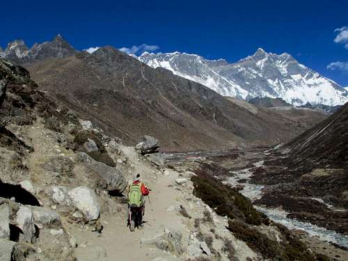
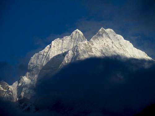
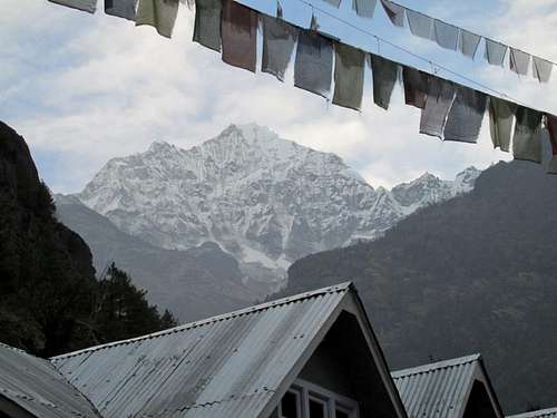
December 14: Namche Bazaar to Tengboche (Nepal)
Today was one of the most beautiful days ever and the most spectacular to date on this trip. The views of Everest, Lhotse, Nuptse, Kangtega, Ama Dablam, etc., were spectacular.
Tengboche was our destination. On the way up we met someone from Singapore who was really altitude sick. We advised him to descend, but he pushed on to Tengboche.
Once at Tengboche we rested and admired the views of all the surrounding mountains. The sunset was really beautiful and after dark we saw several shooting stars, including the biggest and brightest one that I have ever seen.
December 13: Thame Gompa (Nepal)
We awoke to more snow and cloudy skies. Most other trekkers decided to hang around Namche Bazaar, but we decided to hike to Thame Gompa through the snow.
One porter stayed with us and we sent one back to Bangkar to pick up the pillow I left there the night before. It’s hard to sleep without my pillow since I am used to having my arm around my wife at night. I didn’t tell the porters that this is why I needed it though. At least I didn’t send them back for a teddy bear or something.
After calling my wife Kimberly, we hit the trail while it was snowing. The snow really didn't accumulate much, so it wasn't a problem, but it did hide the spectacular mountain views we were supposed to have. Even though it was overcast and snowing, the villages were interesting as were the monasteries.
We did get a few peekaboo views as we headed up the trail, but most of the peaks were hidden. We did pass many yak trains, saw Tahrs, the Himalayan mountain goat, and several pheasants. Also passed was some interesting artwork on the cliffs and several frozen waterfalls. We also saw an interesting natural arch at the bridge across the river as well.
Because it was cloudy, we were unable to see into Tibet, but we made our way to the interesting village of Thame. Not many trekkers or climber come here and in December, even less, so what lodges there were appeared to be closed for the season. Our porter was able to find someone to cook us lunch and the people as the lodge were really happy to see us.
After lunch we climbed up the hill to visit the impressive Gompa. The clouds also began to break and we got some occasionally views of the lower mountains.
On the way back it began to snow harder and the bad weather stuck with us until well into the night.
December 12: Bengkar to Namche Bazaar (Nepal)
We finally got a good night sleep (the first in many days) since it's much quieter in the mountains than it was in Kathmandu. It was 34F (1C) in the morning and we actually got some views of Thamserku. The clouds quickly rolled in though and it began to snow lightly.
It snowed lightly the entire walk to Namche Bazaar. In the late evening it finally cleared somewhat and we got some nice views of some of the surrounding mountains. We explored Namche and emailed home before heading off to bed.
December 11: Lukla to Bengkar (Nepal)
It was a long trip to get to Nepal, but we (Kessler and I) finally arrived the evening of December 11. We immediately wanted to head to the mountains so we booked a morning flight to Lukla.
Because of the fog in Kathmandu, all domestic flights were delayed and we had to wait around the airport for several hours. There wasn't much to do except watch the few monkeys that hang out around and inside the airport. Finally, in the early afternoon we were off!
After arriving in Lukla, and meeting two porters, we ate lunch and walked to Bengkar very quickly. Most people stay the night in Phakding, but we were restless from the long journey and wanted to push on. Clouds obscured most of the peaks along the way. We saw a walking stick insect in the evening. We stayed at a lodge next to a nice waterfall before heading to bed.
See the trip report for more photos and details:
A Return to the Himalaya
December 2: Sand BM (Colorado)
I did an evening climb of the Sand BM. There was no snow and it was completely dry.
December 1: Shrine Mountain (Colorado)
After spending the night in Chuck's Cabin, Kessler, Shaylee, and I decided to climb Shrine Mountain and the Wingle Ridge. Kim stayed behind in the cabin and read while the kids and I climbed the mountain. There wasn't near as much snow as there is normally this time of year and it didn't feel like December. It was 28F on top with only a light breeze and by December standards at nearly 12,000 feet, it was a really warm day. We had some nice views of Mount of the Holy Cross too.
It was also Shaylee's 200th mountain and was a beautiful day!
November 30: Shrine Mountain (Colorado)
Kessler, Shaylee, Kimberly and I hiked up in the dark to 11,209' and spent the night in Chuck's Cabin.
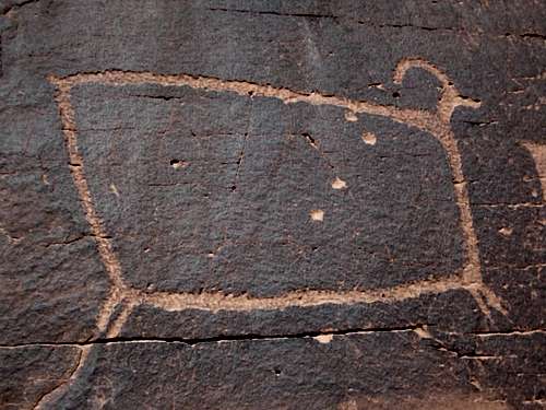
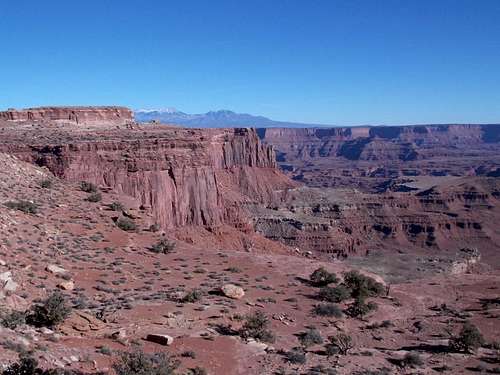
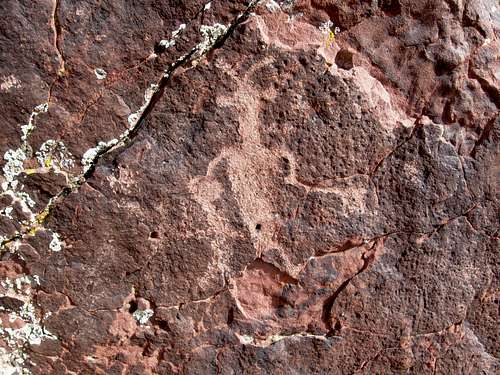
November 25: Sevenmile Canyon (Utah)
Kessler, Shaylee, Kimberly, Shane Burrows, Shauna Burrows, Stormy Burrows, and Diane were going to do the Rubys Ladder Route through Sevenmile Canyon, but we found that the upper ladder had collapsed. Kessler and I found two climbing routes to bypass the ladder, but the group did not complete the route.
We still enjoyed looking around and visited the petroglyphs before heading back home.
November 24: Bighorn (Utah)
Kessler, Shaylee, Kimberly and I met Shane Burrows, Shauna Burrows, Stormy Burrows, and Diane at the Arches Visitor Center for a trip to the Tunnel and Bighorn.
We drove to the trailhead and hiked up Courthouse Wash to the Tunnel before exploring it and climbing to the top of the mesa. We made our way over the Bighorn drainage in a leisurely pace before making the descent.
Most of the drops were down-climbable and we all had a good time. It was a nice laid back day.
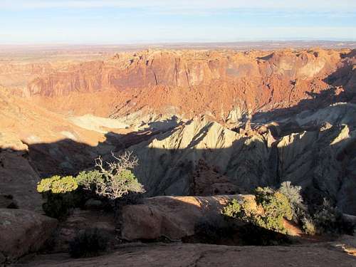
November 23: Aztec Butte/Mesa Arch/Lathrop Trail/Un-Named Butte (Utah)
First Kessler, Shaylee, Kimberly and I climbed Aztec Butte and the smaller butte to the north. The granaries on the southern butte were accessible, but the ones on the main Aztec Butte were blocked by a sign saying not to continue along the ledge.
After climbing Aztec Butte we hiked the short, but beautiful Mesa Arch Loop, including the climb up and over the arch.
After our two short hikes, it was time for a long one. We did the upper half of the Lathrop Trail and climbed an un-named butte as well. In my opinion, the Lathrop Trail area is second most scenic area on top of the Island in the Sky after the Grandview Point to Monument Basin Trail.
November 22: Upheaval Dome (Utah)
Kessler, Shaylee, Kimberly and I first hiked to the Upheaval Dome Overlook, then we did the loop down Syncline Valley and up Upheaval Canyon. We also took the side trip into the crater as well. It was a beautiful day and all three added together made a nice 12 mile day.
November 17-18: Main Canyon/Cottonwood Canyon/Hoodoo Trail (Colorado)
November 17
Kim needed a break from the kids, so Shaylee, Kessler and I went for a big loop hike in the Main Canyon/Little Book Cliffs Complex.
After driving down after lunch time, we arrived at the trailhead around 2 pm. We hiked up Main Canyon, crossing the creek many, many times. Since Jerry Creek (which flows through Main Canyon) was really muddy, we had hoped to make it to Aspen Spring using headlamps since it was unlikely we would make it by dark.
We hiked up Main Canyon to the Cottonwood Canyon junction and everything was pretty easy until then. Going up Cottonwood Canyon we found that the clay was very saturated and the thick mud made the going slow. It was even messier once we reached snow.
Just before dark we had reached the point about half way between the Cottonwood Canyon junction and Aspen Spring. There was a nice flat spot and since we had plenty of snow around to melt for water, we decided to camp there. It would make the next day’s hike long, but we had hoped to get up early and walk out on the frozen snow and mud.
November 18
We had hoped the night would be clear and cold enough to freeze all the snow and mud for us, but the joke was on us and it rained all night instead. Out thermometer recorded that temperature reached freezing sometime during the night, but all the precipitation was rain. Everything was even more saturated by morning.
We talked about returning the same way, but the kids said they wanted to push on with the loop. Part of the going was easy, but much of it was slick mud. We took a break to fill our water bottles at Aspen Spring before climbing to and crossing the plateau.
It was thought that the plateau would be fairly easy to cross, but it was actually challenging because of the mud. The shallow snow would sometimes provide better footing, but the mud under the snow was very squishy.
After Monument Rocks we missed the Crazy Ed Cutoff trail, which was covered in snow, so we had to take a longer route. We eventually made it to the Crazy Ed trail (indistinct) and followed it to the top of the Hoodoo Trail. Near the top of the Hoodoo Trail, we climbed a high butte for a good look around. We were originally going to take the Spring Canyon Trail back to the trailhead, but since it faces north, we knew it would be covered in mud. Instead we took the steep and longer, but dry Hoodoo Trail back to Coal Canyon and then to the trailhead.
We were all tired by the time we reached the trailhead. We had completed 14.5 miles this day and much of it wasn’t easy.
November 11: Malad Gorge (Idaho)
To stretch our legs on the long drive from Boise to Colorado, we stopped at the Malad Gorge State Park for a hike. We went to the end of the trail on the west side of the gorge before returning to the bridge and hiking the east rim to the second set of big lava cracks in the ground. Because it was cool and windy, we stopped there.
November 4: Sand BM (Colorado)
Kessler and I took an evening hike to the Sand BM.
November 3: Deerlodge Peaks (Colorado)
Kim wanted a break from the kids, so I took them camping at Deerlodge in Dinosaur National Monument.
It was 15 degrees in the morning, but it was a beautiful sunny day. Kessler, Shaylee and I hiked through the valley and up to the top of the plateau where we climbed two distant peaks. After enjoying the fine views, we returned to camp.
October 28: Cedar Mountain (Colorado)
Kessler and I made an ascent of Cedar Mountain, even though we did it the day before. There were too many deer hunters on the other mountains (hunting is not allowed on Cedar Mountain). Because of the mud on part of the route the day before, we just did an out and back ascent in good conditions.
October 27: Cedar Mountain (Colorado)
We were originally planning on Quandary Peak, but I had a lot to do and two of us had colds. We also got a later start than wanted, the roads were also in snowpacked conditions and I wasn't in the mood for driving a long distance.
We actually made a night ascent with flashlights of Cedar Mountain. We completed the short loop, but it was muddy at the end from a fresh snowstorm (the long loop is usually not muddy).
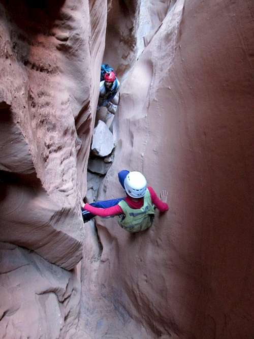
October 21: Bull Pasture Slot (Utah)
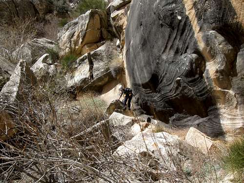
Kessler, five other people and I decided to go through Bull Pasture Canyon today. The canyon is much easier than the one we did the day before, but still has some challenges. There were two rappels and two spicy and fun downclimbs. The slot was nice and we all had a good time exploring the beautiful canyon.
The exit out of the canyon was easy to find and we made the round trip in a respectable 4.5 hours.
October 20: Alcatraz Canyon/un-named dome (Utah)
Alcatraz is one of the best slot canyons anywhere. It is dark, exciting, challenging, and fun.
Kessler, two other people, and I set off to do the canyon. It starts with the exciting rappel off the car bumper and then it’s climbing, squeezing and grunting all the way through. We only rappelled once while actually in the canyon and were able to downclimb everything else. I am probably right at the size limit for the canyon and it is always a grunt to get through. Having Kessler along was a great help since I could give him my pack and he could squeeze through everywhere that I couldn’t.
We all had a really good time and completed the canyon in 5.5 hours, while taking some time to enjoy it. On the way back, Kessler, I and one other person climbed one of the high domes for good photographs and views. It was then a scramble and walk back to the trailhead.
It was very windy that evening. Kessler and I actually moved our tent into the old line shack at Granary Springs because it was so windy.
October 14: Row Bench (Utah)
On the way back from Salt Lake City, Kimberly, Kessler, Shaylee and I went for a hike of the Row Bench Trail in Daniels Canyon. It was a beautiful sunny day and some of the autumn leaves were still out. After an hour we turned back and hiked back to the car for the rest of the drive home.
October 9: Sand BM (Colorado)
I went alone for a climb of the Sand BM. Since my bike has been broken down, I needed some exercise.
October 7: "Timberline Point" (Utah)
What a cold night for early October it was! I recorded a -1F at Hacking Lake! It was the coldest we had ever camped in October. It was cold enough to freeze much of the lake over.
In the morning, Kimberly, Kessler, Shaylee and I did our best to warm up before setting off up the mountain. Originally we were thinking of climbing Leidy Peak, but because it was cold and windy, we decided that Timberline Point would be less so. Besides, I’d never climbed Timberline Point and it is the eastern most peak in the Uinta Mountains that rises above timberline.
It was a bright and sunny day, but not too windy except where the ridge-tops were really open and barren. The spring on the southeast side of Leidy Peak was all frozen over and we walked across the ice.
From there it was a walk along the west ridge of Timberline Point to the summit. Most of it was pretty easy and up and down, but the final saddle before the summit was a bit tedious with deadfall.
We listed to our church conference along the way and spent some time on the peak before heading back the same way. It was a bit cool, but it was a beautiful and sunny fall day.
October 6: Mount Untermann/Lakeshore Peak (Utah)
Shaylee, Kessler, Kimberly and I decided to head for the Uinta Mountains since we could hear our church conference on the radio from up there. The weather forecast was predicting sunny, but cold weather after a dry cold front.
With a late 11 am start, we headed up towards the mountains in sunny, windy, and cold conditions. It was so dry this year that there were hardly any snowbanks at all visible, which is quite unusual for the Uinta Mountains.
After making steady progress, just before Point 11,651, it was remembered that since we switched the stove out at the beginning of the trip, we had left the lighters behind. The original plan was to climb Untermann, Deadman,and Lakeshore Peaks before heading down into the Lakeshore Basin to camp. With the cold weather and with no way to light the stove, we decided to forego that idea.
We decided that Kessler and I should make a run for one or more peaks and that Shaylee and Kimberly would stay behind and on top of Point 11,651. That way we could complete our route by dark.
As fast as we could, Kessler and I set off to climb Mount Untermann. We took only a very brief break before heading towards Lakeshore Peak. We had wanted to climb Deadman Peak and it was tempting to do so since it looked so tantalizingly close, but we decided we shouldn’t make Kim and Shaylee wait that long and to have us all walk out in the dark.
It was disappointing to turn our backs on Deadman Peak, but we headed to Lakeshore Peak as quickly as we could. After climbing Lakeshore Peak, we returned back to Point 11,651 to meet Shaylee and Kim.
Together we all headed back to the trailhead arriving in time to set up the camp before dark. It was a cold and windy climb, but dry and with sunny skies.
September 30: Cedar Mountain (Colorado)
Shaylee, Kessler and I went for an evening climb of Cedar Mountain. Since it gets dark earlier now, we did the short loop, completing it right when it got dark.
September 29: Sawtooth Mountain (Colorado)
Shaylee, Kessler and I went for a climb of Sawtooth Mountains in the Elkheads. Many times we had viewed the mountain from many of the nearby ones, and it looked interesting, but this was the first time we set out to climb it.
We made our way to the trailhead and started out approach to the mountain. We went cross country part way, crossed the Bears Ears Trail before following it a ways and then climbed up to the base of the volcanic dike. We followed the base for a while before climbing up to the top of the dike.
We had hoped to follow the crest of the dike, but it was too rugged and technical so we dropped off the north side. Unfortunately there were several rose bushes to get through, but we followed the north side of the dike westward until they petered out. From there on, it was an easy climb to the summit.
After enjoying the summit and the views of the autumn leaves, we headed down the south face, making a good scramble down a cliff before heading cross country to Sawtooth Park. It was a trail walk from there back to the trailhead.
September 23: Chamber of the Basilisk (Utah)
With two friends, Shaylee, Kessler, Kimberly and I went for a trip through the Chamber of the Basilisk. It was fine, as always, but Shaylee wasn’t in the mood to go this time.
September 22: Quandary Canyon (Utah)
Kessler and I did the challenging Quandary direct route with Tom Jones and other friends during the SUWA gathering. Conditions were challenging and the route was scenic and great. We used sandbags on several occasions. With the fairly large group we went slow and as soon as we reached the mouth of Quandary, the group split up and I too the fast group. We arrived back at camp right when it got dark and the slower group just a little more than an hour later.
It was a great excursion.
September 16: West Spanish Peak (Colorado)
Both Kessler and I had a cold and as mentioned on the Mt Lindsey Log we decided to spend some time outdoors rather than stay home and infect everyone.
We got a late start for West Spanish Peak and didn’t leave the trailhead until 9:15 AM. We made our way as quickly as we could up the mountain and summited at 11:35 AM, which wasn’t too bad considering that Kessler is 10 and we both had colds. It was slightly windy on top, but not nearly as much as the day before. It was still a bit hazy from the forest fires as well.
We met two other people on the summit (one of which we passed on the way up) and ate a good lunch before heading back down. We made our way quickly down the mountain since it was a long drive back home.
It was a nice little trip.
September 15: Mount Lindsey and Iron Nipple (Colorado)
Kessler was supposed to sing in a church activity, but we both had colds and Kessler had a very sore throat. Rather than stay home and infect everyone (both at home and in public) we decided to break away and go spend some time climbing mountains. We only decided to go about 10 minutes before we left. Gear was quickly thrown in the car and we drove south before spending the night.
The next morning we went for a climb of Mt Lindsey. We made our way up the mountain as quickly as we good, but got sidetracked on a false trail below timberline. We found the error and the correct route and then made our way quickly to timberline. From timberline, it was obvious that much of the route was snow covered.
We hiked over to the couloir and then climbed it. It was pretty icy in places, so we had to be careful. We passed several people in the couloir while making our way up the mountain. We summited in 2 hours 45 minutes, which wasn’t too bad for hacking and coughing. We had some nice views, but it was hazy because of forest fires.
It was very windy on the climb up, but the summit was surprisingly calm. One lady on the summit had banged her leg up good when she slipped on the ice.
After a long lunch we headed back down the mountain via the icy couloir. I slipped a couple times and it was found that the walking stick I stashed on the way up was gone. I assume that someone was having trouble with the slippery conditions and took it. Anyway, I bruised and scraped my side in a short slip before reaching the saddle.
From the saddle, it was decided that we would climb Iron Nipple, but because my walking stick was gone and since I tend to get sore knees without it, we wouldn’t climb Huerfano Peak. We climbed Iron Nipple, which was more interesting than expected before heading back down the mountain and to the vehicle. After that we drove to the Walsenburg area to get ready for a climb of West Spanish Peak.
September 8: Sheep Mountain (Colorado)
Kessler, Shaylee, Kimberly and I went for a climb of Sheep Mountain, which is the second highest mountain in the Flat Tops. The mountain looked easy on the map, but the road up South Derby Creek was much rougher than expected (even with a 4wd) and we didn’t make it to the trailhead the night before.
In the morning we started up the rough road, but we tired of beating the vehicle up and parked just above Still Water (not be confused with the Stillwater Reservoirs farther north). We walked the road to Crescent Lake and to Mackinaw Lake and found the trail to the pass in surprisingly good condition, considering that it isn’t used much.
From the pass, we climbed the easy West Ridge of Sheep Mountain to the summit. We (everyone but Kimberly) climbed the other sub-peaks as well. After enjoying the summits, we descended the south face of Sheep Mountain. This was a mistake as the rock and gravel were quite loose and it was much less pleasant than the West Ridge.
After reaching the 4WD trail, we walked it a short distance to the vehicle. It was a good climb, but it took much longer than expected due to the fact that we didn’t drive the road to the end and because descending the south face was harder than expected.
It was still a good climb and the autumn leaves in the area are already at peak color.
September 3: Sand BM (Colorado)
Kessler, Shaylee and I made an evening climb of the Sand BM. It was a nice leg stretcher since we spent the morning on an airplane.
September 2: Aspen Butte (Oregon)
Kessler and I climbed the peak from Clover Creek.
The day before we climbed Mt McLoughlin, but the sky was very smoky and the views weren’t that great. September 2 was much clearer so we decided to climb Aspen Butte. It was a nice little climb and the views were better than they were the day before. It was still too smoky to see Mt Shasta though. We still got a good view of Mt McLaughlin and north to the Mt Thielson area.
There were four other people climbing the mountain and two others seen on the trail, but it was a much less popular climb than Mt McLaughlin. There were no mosquitoes so early September must be a good time to climb.
September 1: Mount McLoughlin (Oregon)
The original plan was to climb Mount Rainer, but my work didn’t allow me to get Friday through Tuesday off so I had to change plane tickets/destinations. Plans were changed to Mount McLoughlin since it’s a solitary mountain and I had too many peaks on the wish list for areas like the Three Sisters or Crater Lake that could be completed in just a weekend.
My son wanted to join me as well so we flew to Medford late Friday night. The next morning we picked up a rental car and had to go shopping, so we didn’t begin the climb of Mt McLaughlin until 10:30 AM. We made good time up the mountain and found ourselves on the summit for a late lunch.
The skies were completely cloud free, but there was much smoke in the air from forest fires down south, so the views were a bit disappointing since we couldn’t see Mt Shasta or the Three Sisters. It was still a nice climb and we made it down the mountain rather quickly and with plenty of time to set of camp at Lake of the Woods and to have a nice BBQ buffet there. The only mishap was that there were many hornets on the way down and I got stung twice.
August 25-26: San Luis Peak
School was starting the next week and work has been stressful, so we thought we would climb another 14er. This time we took aim on a much easier objective; San Luis Peak in the San Juan Mountains.
August 25
Kessler, Shaylee and I left late morning from Craig to drive to the Stewart Creek trailhead. The drive took longer than expected, so we didn’t get there until evening.
It was raining right when we started the approach. We made steady progress up the trail, especially since we didn’t take any rest in the rain. I was planning on camping somewhere near the highest beaver ponds shown on the topo map, but the trail has been recently rerouted leaving much of it near timberline to be high and dry.
Once at timberline, the creek was far below, but we weren’t worried since I could make a run down to water if needs be and there was still a lot of daylight available to backtrack if we didn’t find a campsite.
We ended up finding a nice little stream and a sheltered place in the willows well above timberline at 12,350 feet; about 100 feet above the trail and next to some lonely and tiny little stunted trees, about the highest little trees in the basin. The willows provided shelter and since it was a small semi-flat place in the middle of a steep slope, lightning danger would be minimal (less than in the trees around timberline). The ground was lumpy and the high altitude would make sleeping a little harder perhaps, but the views were great, the clearing skies meant that the stars would be in full view, and the sun would reach this place much sooner than it would back in the forest.
August 26
After a nice night (we could hear the wind at night, but the willows provided shelter and the wind didn’t blow the flaps of the tent much) we woke up just before sunrise. It was 34F. We took our time getting ready in the morning since it was a bit chilly and windy. We then hiked back down to the trail and started up the mountain under completely clear skies.
We made steady progress up the mountain and stopped to watch a marmot not far below the saddle. The rest of the climb went smoothly and we had the mountain to ourselves until we reached the summit at 10 am where a few other climbers had also just reached the summit from the other side.
We spent 35 minutes at the summit before heading back down. When we reached the summit of San Luis, the skies were clear, but by the time we left the summit there were some small puffy clouds. We hiked back to camp and packed up under skies that were getting cloudier as time went on.
We headed down the mountain and eventually the rain and thunder came around noon, but we were well below timberline and back in the thick forest. It rained most of the way down, but that didn’t bother us much. It was a nice little getaway.
August 17-18: “Ptarmigan Flat Top” [Peak 12,008] (Colorado)
August 17
Kessler, Shaylee and I went for a climb of “Ptarmigan Flat Top”, the peak on the west side of Mandall Pass in the Flat Tops. We left Friday afternoon and drove the 1.5 hours to the trailhead before starting up the mountain.
When we started out, the skies were very smoky (from distant forest fires), but free of clouds. The weather forecast was good, but the sky quickly clouded up and it began to rain and then snow (though the snow didn’t stick). Because of this we only made less than two miles before setting up camp, just before the stream crossing of Mandall Creek.
August 18
After waking up to clear skies and a rather cool 30F (enough to cover the ground with a good layer of frost), we ate breakfast and headed up the mountain. We made our way rather quickly to the base of Mandall Pass, but we lost the trail near the base of the pass. We picked up a cairned route, but it got into some loose scree (which in normal years would always be covered in snow) which we had to slog up before reaching the final slope below the pass.
Once as Mandall Pass, we made our way up to “Ptarmigan Flat Top”. We saw 21 marmots and several pikas along the way; I believe 21 marmots are the most I’ve even seen on a mountain.
The climb was easier than expected (one steep place, with gentle grass slopes) and we found ourselves in the summit area earlier than expected. We had to search around for the summit since the top is a huge nearly flat expanse of tundra. We found many ptarmigans right on the summit and we photographed them.
After finding the top we signed the summit register (with very few signatures) and set off to two other points in the distance that looked like they might be higher. It was found that the first point we reached was the highest.
After a rest and snack, we headed back down the mountain. We made a short side trip to Black Mandall Lake before heading back down to pack up camp and then heading home. Despite the cool start, it was a hot day for high altitudes. It was a good trip.
August 12: Green Mountain Falls (Wyoming)
On the way back from our anniversary get-a-way, we stopped to walk to Green Mountain Falls. The Subaru couldn’t make it very far up the road to the trailhead, so we walked most of the 4wd road. Some ATVers were illegally trying to drive the trail, but other than that the hike was very pleasant.
We startled an elk about half way to the falls and there were many chipmunks and squirrels running all over the place. After reaching the falls we took a rest and talked before heading back to the trailhead.
It was a great weekend to celebrate our 19th anniversary.
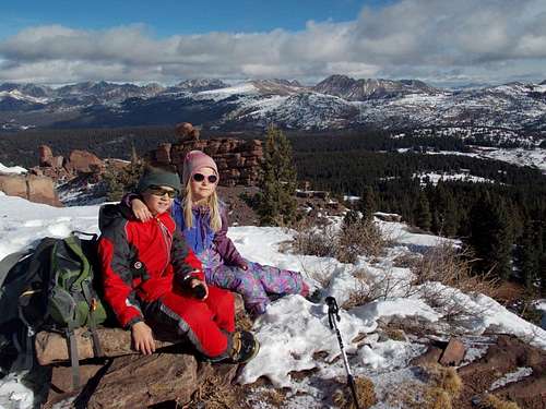
August 11: Medicine Bow Peak (Wyoming)
Beautiful Kimberly and I climbed this mountain (again) for our 19th anniversary. We did the big loop hike from Lake Marie.
It was windy and cold going up and we had a brief lunch on the summit before it began to snow!! The snow was fine, but then it began to hail hard and rain, which made the rocks slippery. We made our way down the mountain until we found the snowfield in the photo where we could have our friendly annual anniversary snowball fight. After that we completed the beautiful loop hike passing by many spectacular lakes and seeing many pikas and a marmot.
After we were pretty wet from the hike, it was time to go back to the resort and eat dinner before soaking in the hot springs.
August 3-4: Maroon Bells (Colorado)
I have been doing several climbs with my 10 year old son Kessler, but the class 4 peaks such as Pyramid (completed on June 30) are no longer very challenging for him and he wanted something a bit harder.
After admiring the Maroon Bells from Pyramid Peak, the thought of climbing the traverse was certainly looked appealing. The only problem was that the Maroon Bells Traverse seems to have a rather fierce reputation among climbers. Photos make the route look quite difficult. Could we do it? Were we ready? The ridge is long on class 4 and 5 terrain and is considered to be one of the more difficult connecting ridges between 14,000+ foot peaks in Colorado. Kessler and I had certainly done several technical routes together. Should we just climb one of the peaks and see how things go?
On the weekend of August 4th, several 14ers.com members were also planning on the traverse, which was worrisome because of rockfall, but good because we hoped to find some partners. We expressed our interest in joining up and were ready for to attempt the climb.
August 3
In the evening, Kessler and I hiked to Crater Lake to look for a campsite. Luckily we found an unoccupied campsite and we set up camp before heading to bed. Unfortunately I had trouble sleeping (one reason was that I had forgotten any type of pillow, the other was that there were several animals stirring in the bushes).
August 4
Today was the big day. We got a later start than we had wanted to and didn’t start until 6:30 AM. We made our way quickly up North Maroon Peak. Because there were several people on the route, we wanted to get ahead of them to avoid rockfall. We passed probably 15 people on the way to the summit and summited in a rather quickly 3 hours 20 minutes. Along the way we climbed several of the cliff bands directly, both for fun and to avoid crowds.
Once we were on the summit, there were two other climbers preparing to climb the traverse. We asked if we could join them until after the rappel. They accepted and because they were leaving right then we immediately left the summit of North Maroon without stopping or even snapping a photo.
We made good progress along the traverse and passed the 14ers.com members near the rappel. Our group of four rapped down the rappel, but there were still many climbing obstacles between the rappel and the notch/lowpoint between the Maroons.
We made steady progress and basically stayed on route until the low point. On the climb up to Maroon Peak, Kessler and I got into a nasty gully that was a pain to climb. We were a bit off route and this was the worst part of the traverse.
Eventually Kessler and I summited Maroon and decided to eat lunch. It has taken us 1 hour 40 minutes to complete the traverse, which is supposed to be a pretty good time. We waited for the other two climbers (we never did catch their names!) at the summit before bidding farewell and heading down the mountain.
On the way down we got a little off route because we stayed too close to the ridge crest right from the summit. We crossed a notch and followed a cairned route up the other side. The cairned route eventually petered out at a sub-peak and we were forced to backtrack, losing almost an hour. This route was the only route on any 14er where I have ever gotten off route so far.
The descent of Maroon Peak was a pain and after making our way back to the standard route and along all the ups and downs, we were “home free” as all as we had to do was descend directly down to Maroon Creek. The route down was relentless and loose though and seemingly took forever. It took us longer to descend Maroon Peak than it did to climb North Maroon and do the traverse.
We arrived at camp rather tired, so we took a short rest before packing up and heading for home. On the way down we chatted with several people.
The Maroon Traverse was a good one, but with much loose rock, it has a higher risk factor than most other 14er routes. The route was fun to the summit of Maroon Peak, but the descent of Maroon Peak is relentless, not too aesthetic and isn’t a route I’d care to repeat. Other than the descent of Maroon Peak, Kessler had a blast and is excited to do more 14er traverses. I had a good time too, so it was a very successful trip.
See the trip report for more details and photos:
Ringing Hell's Bells
July 29: Sand BM (Colorado)
Kessler and I made an evening hike of the Sand BM.
July 27-28: Mount Zirkel (Colorado)
July 27
Mount Zirkel was the chosen climb for this weekend. Kim needed a break, so it was the kids (Kessler and Shaylee) and I. I actually got off work late, so we wouldn’t get as early start as I had hoped. We arrived at the trailhead a little after 6 pm and started up the mountain.
As we hiked along the trail, it began to rain, sometimes rather heavily. We crossed the stream on a long log and quickly made our way to Gold Creek Lake in about 1.5 hours. It was still raining hard which made the next stream crossing slippery. Kessler slipped off the rocks and into waist deep (and cold!) water. He wasn’t happy and we found a campsite as soon as we could. After setting up the tent, the kids got in and took off their wet clothes while I cooked dinner and filtered water in the rain. We made about 3 miles, so tomorrow’s climb would be long. Luckily the weather cleared just after sunset.
July 28
It was 36F in the morning and clear, which was a good sign. Our boots were still wet (I should have snow-sealed them before the trip) so they weren’t fun to put on. We hiked rather quickly up the Slavonia Basin before taking our only rest on the way to Red Dirt Pass. We then climbed to the pass for a final rest and to get a good look at the weather. The weather was still clear so we took a break and headed up the ridge towards Mount Zirkel. The kids wanted to climb the subpeaks as well, so we climbed several of those (up to class 3 in difficulty) before climbing up to the main summit. There was some boulderhopping, but it wasn’t a difficult climb.
After soaking up the spectacular views in great weather, we headed back down the mountain and packed up camp. We then hiked down. The biggest incidence was while taking our final rest, literally hundreds of hornets came pouring out of the ground from under a rock. We didn’t hang around and quickly hiked back to the trailhead.
By the end, our feet were quite sore and we were tired. Including the subpeaks, we had hiked for 15 miles today and with much elevation gain. It was still a great climb and a beautiful peak.
July 22: Cedar Mountain (Colorado)
Because we ran the Yampa River with my brother the day before, I didn’t get a climb in so I decided to climb Cedar Mountain in the evening, completing the loop hike. I should have brought a headlamp because it was really dark not long after sunset, which made the climb down difficult. I had a few stumbles before getting back to the trailhead.
July 19: South Castor Peak (Colorado)
Since my bike was broken down and I had to drive to work, I went on a climb right after I got off work. I climbed South Castor Peak in the Williams Fork Mountains. It was a hot afternoon and evening, but was a nice climb.
July 13: Cedar Mountain (Colorado)
I made an evening climb of Cedar Mountain via the long loop. I saw a deer, a snake and many birds. I was hoping to get a good sunset, but clouds put an end to that idea.
July 12: Sand BM (Colorado)
Kessler and I made a climb of the Sand BM. There were quite a few deer about.
July 11: Sand BM (Colorado)
I made a late evening climb of the Sand BM.
July 7: Doane Peak/Red Mountain (Wyoming)
Originally we had planned to climb some of the more challenging 14ers, but the weather forecast put an end to those plans. Last minute, Shaylee, Kessler and I decided to head up to the Sierra Madre in Wyoming. Originally I was thinking of climbing Quartzite Peak, but with the weather, I changed plans and decided that we would hike the Baby Lake Trail from Battle Mountain Pass down to the Baby Lake Trailhead.
After starting the trail, when we neared Doane Peak and Red Mountain, there was no thunder so we decided to attempt both peaks. Both climbs went well, but Red Mountain was the best of the two climbs since it had some interesting little scrambles and great views. It was raining at the summit.
After climbing the peaks we headed down Red Mountain and met the trail right where the junction of the Baby Lake Trail and Continental Divide was. We followed the Baby Lake Trail west and found out that after the first initial easy to find section that the trail was more a route than a trail and had been given back to nature especially in the blow-downs and marshy areas. We had continuing rain on and off and it began to thunder as well. We had to pay close attention to the trail markers and lost the trail several times.
Eventually the trail conditions improved and we made our way back to the highway. We had walked a total of nine miles in five hours, including quite a bit of off trail travel, so it was time for a rest. We had to wait 30 or so minutes before catching a ride back up to the pass.
July 4: Black Mountain (Colorado)
After making Kimberly breakfast in bed and going to the 4th of July parade and the community BBQ we couldn’t start a climb until afternoon. Shaylee, Kessler and I decided to climb Black Mountain. The skies were cloudy and there was no thunder.
We made a quick nonstop climb of Black Mountain from the Southeast Ridge. It sprinkled very lightly for a few seconds, but other than that there was no rain. If fact, the cloud cover was actually pleasant since we were in the middle of a heat wave. The snow was completely gone, the first time I have seen it gone before August.
June 29-30: Pyramid Peak (Colorado)
June 29
The plan was to get a late afternoon start to hike up to Crater Lake, but Kim got stuck at work late and we (Kimberly, Shaylee, Kessler and I) didn’t leave the trailhead until after 8 pm. We hurried to the lake with our backpacks and arrived in a pretty quick 45 minutes. It took a while to find an empty campsite and we set up camp in the dark.
We me Kevin, his 15 year old son Tristen and his 13 year old Chance who was camped next to us. He knew Kessler and expressed his interest in joining us, so we agreed to do a joint climb of Pyramid in the morning.
June 30
Kim and Shaylee stayed behind at the lake, while Kessler and I headed from Crater Lake shortly after 6:30 AM. Once we started up the steep slope we saw the others below and waited for them to catch up. Kessler and Chance were the speedy climbers of the bunch and they had to wait for the rest of us several times. After crossing a few snowfields, we we climbed up to the saddle where I told Kessler to wait for us (they beat us by 25 minutes).
Kessler, Chance and I made the rest of the climb to Pyramid. We were ahead while Tristan and Kevin took up the rear. The route up to Pyramid had some fun exposed scrambles, but was easier than expected, especially the route-finding part. We got off route a little once, but other than that the route was pretty obvious and easy to find.
We found ourselves at the top in just under 4.5 hours of climbing. After a long lunch to wait for the others we headed back down. At the saddle, Kessler and Chance went on ahead and beat us to the lake by 45 minutes. We then bid farewell to the others before packing up camp and heading back down to the trailhead.
It was a great climb and with perfect weather.
See the trip report for more photos and details:
Pyramid Peak
June 23: Single Tree Creek and Sulphur Creek (Utah)
Kessler went to Cub Scout day camp today, so Shaylee and I decided to go play in Southern Utah since she likes the water so much and since it would be a good place to escape the heat.
We met Dean, his wife Amy, and two daughters Haley and Marlee at the Single Tree Campground. We first decided to check out the canyoneering potential of Single Tree Creek. We went down to the waterfalls and checked things out before returning to the trailhead to gear up.
We went to rap the waterfalls, but Haley and Marlee didn’t want to, so along with Amy they bypassed them. We all met again and followed the creek for a ways, but it became evident that the canyon was only going to stay a wide valley down below, so we returned to the trailhead and headed for Sulphur Creek.
Even though I just did Sulphur Creek the month before, we did it again since we knew that it was always a good choice in hot weather. All of the kids had a blast in Sulphur Creek and we took our time through the canyon. It was easier than the month before because the water was clear and there was much less of it.
It was a great day.
June 19: Sand BM (Colorado)
Shaylee, Kessler and I made a climb of the Sand BM in windy conditions.
June 16: Slater Peaks (Colorado)
Today, Shaylee, Kessler and I decided to climb the Slater Peaks. After driving to the trailhead, we made our way up the dusty trail to the saddle between the highest Slater Peak and the one to the north. We decided to climb the big one first. There was no trail from here on; the route was quite slippery in a few places and was steep, but we made it to the summit with no problems. There were some snowfields, but we could avoid them. We found that there were 6 signatures in the register in the past nine years, indicating that the popularity of the peak pretty average for the higher summits in the Elkhead Mountains.
After climbing “Slater Peak” we made our way back down to the saddle. Shaylee fell three times on the way down and Kessler and I one each.
From the saddle, we climbed “North Slater”. It was an easier climb since it was only steep at the end. We found four signatures in 14 years in the register.
After climbing the peaks we returned down the trail to the trailhead. Because it has been so dry, the trail was really dusty.
June 9: Crater Lake (Colorado)
After rafting the Roaring Fork River, Justin Kuhn, Kessler, Shaylee and I went for a hike to Crater Lake in the Maroon Bells/Snowmass Wilderness. The hike is not difficult, but it is one of the most scenic ones in Colorado.
We enjoyed the views from the lake before heading back down. It was perfect weather the entire time.
June 8: Cave Rock (Colorado)
In the evening, Shaylee, Kimberly, Kessler and I went for a hike to a local cave. After seeing the small cave we hiked to the top of the rocks above the cave before heading back home.
June 6: Cedar Mountain (Colorado)
It was time for an evening hike, so Kessler, Shaylee, Kimberly and I went for a climb of Cedar Mountain. We completed the entire loop without resting and had a nice view of the sunset on the way down.
June 2: Mount Antero (Colorado)
Shaylee, Kessler and I decided to climb a 14er this weekend. We decided on Antero since I hadn’t done it yet and since it was assumed (correctly) that it wouldn’t require an ice axe.
After getting up fairly early we drove a ways up the 4wd road before parking. Antero is an easy mountain for a 14er, but the climb can be a bit tedious. We grinded our way up the Jeep road to the saddle and then climbed to the summit on the steep rocks. We summited around 10:30 AM.
It was sunny going up, but clouds were gathering when we were at the summit, so we didn’t spend long on top. After enjoying the view we made our way quickly down the mountain. There was a little thunder and it began to snow very lightly. Since we were on a north south ridge with a drop off to the west the snow was "falling upwards". Not at an angle, but straight upwards caused by the updrafts buffeting the mountain. It wasn't that windy, but since the snow was light and fluffy, it was "falling" completely vertically and upwards. It wasn't blowing wildly up, but looked just like it was falling up, in the same manner that it falls down. We felt upside down!
After the brief snow and wind, the weather was good and we were back to the vehicle in no time. It was a nice little climb.
May 31: Black Mountain (Colorado)
Shaylee, Kessler, Kimberly and I decided to climb Black Mountain (via the Southeast Ridge) after I got off work. After eating dinner, we were off to the mountain. Since it was late, we hurried as quickly as possible in order to complete the 6 miles round trip before dark. There were a few snow patches and many fallen trees to contend with, but no major problems. The worst part was the mosquitoes. I didn’t think they would be out this early in the year, so didn’t bring repellent.
We found ourselves on the east summit after 1 hour 18 minutes. After a break, we made our way back down the mountain in a quick 1 hour 8 minutes. The kids are certainly getting faster and this was a good training hike. There was much less snow than is usual for this time of year.
May 28: Sulphur Creek (Utah)
Because today was supposed to be the hottest day of the three day weekend, Shaylee, Kessler, Kimberly, Jeremiah and I decided to explore the deep slot canyon containing Sulphur Creek. This is probably the 2nd best non-technical hike in the park, after Halls Creek Narrows.
We started from Chimney Rock and followed the side canyon down to Sulphur Creek. As we continued down canyon we could see people way up on the rim (an NPS roadside overlooks exist up there) 800-900 feet above us. They could see us well enough to wave.
We continued down canyon through the nice narrows. Even though it was a warm day, we still got chilled slightly with all the water around. There were three challenging waterfalls to climb; otherwise the only other challenge was just lots of wading and rocks. The kids had a lot of fun climbing the waterfalls.
The last waterfall was the messiest of all and required some delicate maneuvering. After the last waterfall, it was a nice and pretty walk all the way to the visitor center.
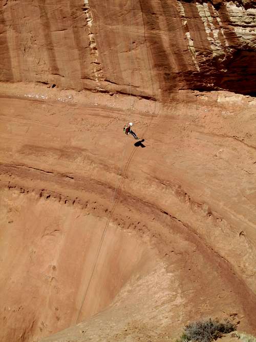
May 27: Cottonwood Wash (Utah)
Cottonwood Wash was our next adventure in Capitol Reef. This time, Shaylee wanted to spend time with her cousin, so Shaylee, Kimberly, Josh (her cousin), Mark (my brother) and my dad would hike as far as they could upcanyon from the bottom. Jeremiah, Kessler and I would descend the entire canyon with technical gear.
We found the approach to upper Cottonwood Wash to be quite pretty. It was easier than the approach to Burro Wash too.
After many minor obstacles, we found ourselves at the first rap into the slot. Jeremiah went first and I last. Kessler had a lot of fun on the raps and challenging downclimbs.
The second rap was into a nice alcove. Normally it has some hanging gardens, but it had been so dry that there wasn’t too much greenery left. The canyon became a very beautiful slanted slot with many banded colors; perhaps the best part of the canyon. The narrows and obstacles continued and there were many more challenging downclimbs to come and two huge dry falls to climb around.
Eventually we found ourselves at the last rap which was off a deadman cairn, but the narrows and obstacles continued for a long way down canyon. It was all great fun.
Eventually we made our way all the way through the canyon and back to the second vehicle. This night, we were tired of all the sand and wind so Kim, the kids and I went to go stay at the nearest B & B for a good night’s rest!
May 26: Burro Wash (Utah)
Burro Wash was our first adventure on this Capitol Reef Trip. With extreme winds and dust storms, it was a rough night the night before. We ended up setting up our tent in the culvert pipe for some wind shelter. Before we even started the canyon our ears and everything else were filed with dust and sand!
Kimberly (wife), Shaylee (daughter), Kessler (son), Jeremiah (friend from Canada) and I drove to the head of the canyon to make a full descent with technical gear. Mark (brother), his son Josh, and my dad would hike from the bottom end and go as far as they could without technical gear.
After climbing to the head of the canyon and seeing some great petrified logs along the way, we took a slightly difficult route variation that included one nice technical pitch, so it would be a good warm up, we dropped in. It was very windy before we hit the slots.
After some tedious bushes and obstacles we found ourselves as the first slot; this one in the Wingate Sandstone. The canyon alternated between open and tight as we continued down.
After the Wingate slot there were several good slots through the Navajo Sandstone and all of them contained some nice downclimbs with a few rappels. We were able to downclimb everything except for three raps and the kids’ skills have improved much in the past year. The kids favorite part of the canyon was the “slide”.
The second to the last rappel required an exposed climb along ledges to get to the rappel station. After that the final big rappel landed us in a huge and impressive chamber that was spectacular. The action wasn’t over yet and there were still many downclimbs and tight squeezes to go.
The canyon eventually opened up and then it was an open walk though the sand through the open desert. It was very windy, so this made it more difficult than it otherwise would have been, but we made it across the desert without stopping. We were all relieved to make it back to camp, even if it was in a windy culvert pipe!
Burro Wash was a grand adventure.
See the trip report for more details and photos:
Capitol Reef Adventures
May 20: Sand BM (Colorado)
Kessler and I made a quick evening climb of the Sand BM.
May 13: Fish Creek Falls (Colorado)
Kimberly, Kessler, Shaylee and I went for an evening hike to Upper Fish Creek Falls. Since church didn’t get out until 4 PM, we had a quick dinner at the trailhead and didn’t start up the trail until 6 PM. We hurried up the trail as fast as we could and without any breaks and arrived at the falls after 1.25 hours. After a quick rest as the Upper Falls, we returned as quickly as we could and reached the trailhead at around sunset. We had completed the 5 miles round trip with 1700 feet elevation gain in less than 2.5 hours, so we were ready for a well deserved rest when we got home.
May 12: South Fork Buckwater Draw (Colorado)
Kimberly, Shaylee, Kessler and I decided to make a quick canyoneering trip to South Fork Buckwater Draw. We chose this canyon because it can be done on a day trip from our house.
We made our way to the canyon before dropping down the steep slope and into the canyon. The action started immediately and we had a lot of fun with all the down climbs and the two rappels. The kids did great on the downclimbs and their skills have increased much in the last year. After enjoying the canyon it was time to pay the piper and we had to climb out of the canyon. We were tired by the time we reached the vehicle again.
See the trip report for details and photos:
A Return To Buckwater Photo Trip Report
May 8: Fortification Rocks (Colorado)
Shaylee, Kessler, Kimberly and I headed for the Fortification Rocks for some fun climbing and scrambling. We climbed several of the rocks including the highest one and had some fun on the technical routes. The Fortification Rocks are very photogenic, but unfortunately we forgot our camera.
May 6: “East Castor Peak” (Colorado)
I climbed East Castor peak in the evening. The weather was great, but the climb took much longer than I had remembered it taking on a previous trip so I got back well after dark.
April 29: Sand BM (Colorado)
Kessler and I made an evening climb of the Sand BM.
April 28: Bald Mountain (Colorado)
Kessler, Shaylee and I went for a climb of Bald Mountain on a dry and breezy day. We climbed the peak and since I heard that the summit register was in poor condition, I brough a replacement. After climbing the peak, we did some more exploring around the summit and found more fossils and an interesting “monument” on the north ridge.
After exploring around we headed back up to the summit and down the west face.
April 22: Loop Canyon and Un-Named Peak [Needles] (Utah)
I decided to head off alone along the Colorado Overlook Road to do some exploring since I hadn’t been in that area of Canyonlands for several years. I explored around the ledges and ridges above Loop Canyon before descending Loop Canyon all the way down to the final ledge before the Colorado River. I had already been to the River along a variation of the route years ago, so I headed back up the long and steep route out of Loop Canyon. After climbing the highest butte I could find I headed back to the vehicle and drove to the Lower Jump which I hiked down to. Surprisingly it was flowing over the big waterfall at a trickle.
April 21: South Six Shooter Peak and Indian Creek (Utah)
I met Brian C and friends for our climb of South Six Shooter Peak. Noah wanted to climb North Six Shooter (which is a harder climb) so the group split in two. Noah and his partner headed off for their climb while Brian, Joe and I drove up Davis Canyon to climb South Six Shooter.
We found our way up the strenuous approach up the slopes of South Six Shooter to the base of the technical pitches of the tower. There were three technical pitches of rock. The first pitch was straightforward and the second had one scary leap/traverse. The third pitch was the crux. The more in shape Brian and Joe climb it with ease, but I struggled and grunted up the pitch and with folly tried to climb the corner too far right. Once I got my foot on the other side of the groove it was easier, which I should have done in the first place.
It was getting pretty hot by the time we were on the summit and on the final pitches. Brian and Joe climb the second sub-summit tower (which may be slightly higher) before we headed down the rock face.
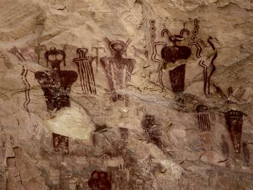
Since Noah’s climb was more difficult, we figured that they would take longer so we headed up Davis Canyon to explore around. I had hoped to show them a big arch/ruin combination back in there, but we wandered around many sometimes precarious ledges and along ridges and still didn’t find it. We then hiked up canyon to some ruins and to the really nice Five Faces Pictograph.
After Davis Canyon we returned to the rendezvous point to find that Noah’s group had been unsuccessful due to the unusually hot weather (the owner of the Needles Outpost said she recorded 93F that day).
I asked the group if they wanted to visit a swim hole and they all said yes. We drove to the waterfall and pool for a refreshing swim (where we also set up camp). After swimming we climbed some minor, but fun rock buttes (the rest climbing two and me one).
April 20: Thompson Canyon and Un-Named Butte (Utah)
On the way to the Canyonlands National Park area, I stopped in Thompson Canyon. I did the short hikes around all the petroglyphs and petroglyphs panels before heading farther up the road to where it ends in Thompson Canyon. I hiked a ways up Thompson Canyon before climbing a high butte for the views.
April 15: Sand BM (Colorado)
Kessler and I made an evening climb of the Sand BM.
April 13: Cedar Mountain (Colorado)
The weather was threatening, so Cedar Mountain was the obvious choice of an evening peak to climb. We completed the medium loop just in time for the bad weather to hit. We had wind and a few snowflakes, but it wasn’t bad at all.
April 9: Cedar Mountain (CO)
Kessler and I made an evening climb of Cedar Mountain. We had a great sunset, but I didn’t bring the camera. We did the short loop and the trail was completely dry. There was no sign at all of snow on the mountain in contrast to most years in early April.
April 6-7: Homestake Peak (Colorado)
Kessler (my nine year old son) and I decided to make an attempt of Homestake Peak, a 13,209 feet (4025 meters) peak in the Northern Sawatch Range. It was going to be a practice trip for the Himalayas later this year, but due to poor snow conditions, the trip turned out to be more challenging than expected.
April 6
Since there were a few spaces left, we made a last minute reservation for the 10th Mountain Division Hut near Slide Lake and drove to the Tennessee Pass, starting up the trail at 2:30 PM. Due to the extreme drought conditions, snow conditions were terrible with much bare ground, mud, ice and crusty snow along with some weak sugar snow in some places (especially around the willows).
We had to take off and put back on our snowshoes on many occasions, which was a hindrance and the going was very slow where I would punch through the weak layer sugar snow and the ice was a struggle with snowshoes as well. It was very windy, but much of the route was protected by trees. We struggled for four hard hours to cover the 5.7 miles (9.2 kms) to the hut and were very glad when we first got sight of the hut.
The hut was supposed to be nearly full tonight (14 people), but it appeared that everyone else whom attempted to reach the hut had given up. We ended up having the hut all to ourselves. We cooked a dinner of salmon pasta and headed off to bed shortly after.
April 7
After a mostly windy night, we awoke to calmer conditions and a rather cool 0F (-18C). The cold front must have just gone through. The cold morning was actually a real blessing and the snow conditions were much better with the frozen snow. We could walk on top of it without snowshoes so there was no constantly switching between snowshoes and no snowshoes.
We set off to explore the Slide Lake Basin before climbing the peak. Slide Lake was a neat area and was interesting when frozen over. We found it easier to walk around the lake on the ice rather than in the willows with the sugar snow.
After exploring the Slide Lake Basin (wandering around checking out various places), we headed to the Southeast Ridge of Homestake Peak for our attempt. We decided to make a steep and direct climb up to the ridge for some checking out of the snow conditions. I also wanted Kessler to practice some rope work on steep snow.
We found a steep and direct route and climbed up it to the ridgetop. The steepest section was 40 degrees, but I had to cut steps in places due to the hard snow. In other places the snow was perfect for climbing and kick stepping and we were glad to find out that it would have been fine for glissading as well.
Once we were on the ridge, it was more or less a straight shot to the summit. We put on our snowshoes, but Kessler’s snowshoes don’t have very good crampons on them, so it was harder for him than it was for me. We could stay on the snow most of the time, but had to cross rocks in a few places. It was breezy in places, but calm in others.
After three hours of non-stop (other than to get a few quick snacks and much water) climbing, we found ourselves on the summit of Homestake Peak! It was a lot of work with the more challenging than normal snow conditions, but the views were worth it.
After 20 minutes on top (where we had lunch), it was time to head down the mountain. I roped Kessler to me so we could do some belay work on the steep northeast face of the mountain which we would use for our descent. We descended the ridge a short distance and then descended onto the steep northeast face of the mountain. Conditions we worse than expected and the snow was pretty icy in places. We cautiously descended the very steep face to a bare rock and scree slope which we would descend until we could find better snow. We were able to do some glissading on the crust, and we attempted to find better snow. We finally did find some reasonable snow on the lower half of the face and had a fast ride down the rest of the face to the valley above Slide Lake.
Once we were at the lake, we descended down to the hut, but overshot it and had to backtrack, losing 30 minutes in the process. After reaching the hut we ate a second lunch, packed up and headed back down the mountain by 3 pm. Again the hut was supposed to be full with 16 people and again no one else had shown up.
This time we decided to try the “summer route” because we were hoping to find better snow conditions. This turned out to be a good move and we only had to remove our snowshoes once at which point we could walk on the frozen crust and bare ground back to Tennessee Pass. It was a tiring day since we had covered a very hard 10 miles (16 kms) and took only a few short rests. We could see where another group had presumably turned back and gave up reaching the hut. We finally reached the pass at 6:15 PM and were very glad to see the vehicle.
Homestake Peak was a hard won summit due to the snow conditions, but it was a memorable trip as well and it provided some good practice for our trip to the Himalayas later this year. I was very sore on the drive home, but Kessler fared better.
See the trip report for details:
A Hard Won Summit: Homestake Peak
April 1: Desert Voices/Un-Named Peak/Fossil Discovery Trail (Utah)
Kessler and I went for a hike of the Desert Voices Trail (Dinosaur National Monument). We hiked the loop and took a detour to climb an un-named peak for some fine views.
Later in the afternoon Kessler, Shaylee, Kimberly and I hiked the Fossil Discovery Trail to the Dinosaur Quarry. There were many fossils along the trail and it added a little excitement over driving up to the Quarry.
March 31: Hog Canyon (Utah)
My brother Richard, his wife Holly, friend McKenzie, Kessler and I decided to try a canyoneering adventure in Dinosaur National Monument. We tried Hog Canyon and climbed up the challenging ridge between Hog and Box Canyons. The ridge was 4th class (maybe a little harder) and quite exposed in places, but we found a possible route into Hog Canyon.
We descended an incredibly steep chute that was quite technical with several 5th class downclimbs and three rappels. It was a little intimidating, but after much work, we made it to the main canyon and then down canyon to known ground.
It was a great adventure, but we missed part of the upper slot of Hog Canyon, something that we will have to attempt in the future.
March 28: Yampa River Trail (Colorado)
I hiked a section of the Yampa River Trail. It was almost dry with only a little mud and no snow, something highly unusual for this time of year.
March 24: Gates of Ladore/Vermillion Creek/’Vermillion Peak” (Colorado)
Last night Kessler, his friend Kayden Herring and I camped at Gates of Ladore Campground and first thing in the morning we hiked the trail to the Gates themselves. After that we drove to Vermillion Creek to look for the petroglyphs. We did find them, but Vermillion Creek was too high and cold to cross so we had a difficult hike through brush and loose rock. After climbing some loose exposed and ledges to get to a big panel of petroglyphs, we decided we had enough of the canyon and climbed up the west wall.
We then decided to climb the highest peak around (“Vermillion Peak”) for some views. After climbing the peak, we returned to the vehicle and visited the road side attractions of the Irish Canyon Petroglyphs and Vermillion Falls.
March 22: Cedar Mountain (Colorado)
I did a sunset climb of the short loop on Cedar Mountain. There was one section of snow to cross near the summit ridge, but that was it.
March 21: Sand BM (Colorado)
I climbed Sand BM alone. There was only a little mud and one snow patch.
March 17: Main Canyon (Colorado)
Kimberly and I took a hike up Main Canyon (in the Little Book Cliffs WSA) to the Spring Canyon confluence. Along the way we saw many wild horses. It was a nice little hike.
March 16: Fourmile Draw/Mount Garfield (Colorado)
I gave a slideshow in Vernal the evening of the 15th and then had to be in Palisade the next night. On the way between Vernal and Palisade Kimberly and I stopped at Fourmile Draw in Canyon Pintado. We hiked the supposed two mile (according to some sources; we believe the loop is shorter) loop past the pictographs and petroglyphs.
After Fourmile Draw we headed to Palisade. We still had time to climb Mount Garfield.
It was really windy, but we made the climb anyway. It was almost hot climbing up the mountain and we made our way rather quickly to the summit. After enjoying the fine views, we returned down the mountain. I didn’t bring trekking poles, so the very steep climb down was very slippery.
March 14: Sand BM (Colorado)
Kessler, Shaylee, Kimberly and I climbed Sand BM in the evening. This time it was drier than before and there were only a few small snowbanks and a little mud.
March 10: Peak 6690 (Colorado)
Kessler and I had planned to climb Bald Mountain and the Godiva Ridge. Since it has been so warm and dry we could see from a long distance that the south slopes of the mountains were mostly dry.
When we got closer to the mountain, however, it was found that the roads were extremely muddy. After narrowly missing having the car getting completely stuck we decided to climb an un-named summit instead.
We climbed the highest un-named peak that we could see from the road and then we saw another one out in the distance. We decided to climb that one too, but the alternating deep snow and mud caused us to be unsuccessful. We returned back to the vehicle covered in mud.
March 9: Sand BM (Colorado)
Alone, I went for an evening hike of Sand BM. I saw many deer. There was a little snow and mud, but with quite a bit of dry ground.
March 3-4: Beatty Bear Hut (Colorado)
March 3
Kim, Kessler, Shaylee and I had a reservation to snowshoe up to the Beatty Bear Hut in the Sawatch Range north of Mount Massive. The hut is one of the more challenging ones to reach in the 10th Mountain Division Hut System (though it’s easier to reach than the nearby Skinner Hut).
Since the hut requires a 7 mile approach with 2000 feet elevation gain, most of which is at the last part of the route, the plan was to get an early start. I quickly learned a less though, that if you want an early start, do not spend the night at a hotel with a hot tub!
Because it snowed that night, the drive was very slow and with our late start in the morning we actually didn’t hit the trail until 11 AM. It was overcast, but a previous group (luckily) had broken trail through the fresh snow.
We brought headlamps just in case, but our goal was to make it to the hut before dark (the guidebooks say that the route should take 6-8 hours). We didn’t dilly dally around much and went non-stop except for three short breaks.
We made our way quickly to the steep climb for our final rest. After climbing over the highpoint we unexpectedly found ourselves at the cabin. We had made the entire route in a fast 5.5 hours. It was still overcast so we didn’t get many views.
March 4
After waking up in the morning to 7F, we found ourselves with perfectly sunny skies and great views. We admired the views while having breakfast after which we packed up and headed down the mountain, wishing we could stay longer.
We make it back to the car in four hours and had spectacular views the entire way down. It was a great little trip.
February 27: Yampa River Trail (CO)
I took a hike along the Yampa River Trail in windy conditions. Some snow and quite wet and muddy (more typical of April conditions).
February 25: Walton Peak (CO)
Kim needed a break from the kids (and me), so Kessler, Shaylee and I decided to climb Walton Peak. The kids said they wanted to try something hard, but we didn't know if we could make it or not since in winter it's a 12 mile round trip on snowshoes.
We got a late start, but the kids persevered to the summit. The weather started out clear, but it was windy so in open areas there was a ground blizzard. The kids still had a great time though by the end Shaylee was tired. 12 miles on snowshoes is pretty good for a seven year old girl, even if she is tough. We got some good sliding in on the way down.
After climbing the peak we stopped at Wendy's in Steamboat and then headed home to Kimberly's open arms. It was a great day!
February 20: Box Spring Canyon (Utah)
We were afraid of hitting snow to the east of Green River, so we backtracked to the San Rafael Reef. We (Kessler, Shaylee, Kimberly and I) decided to explore Box Spring Canyon (between I-70 and Black Dragon Canyon) in the San Rafael Swell.
We all hiked up the canyon, fighting brush in places until reaching a big falls and pool. I wanted to explore the canyon above, but since the others weren’t interested, they waited at the falls and pool.
With all my technical gear, I retreated down the canyon until I could climb the south wall. Before descending the canyon I climbed to a high point on the rim so I could view more of the canyon. I retreated back and followed the rim of the canyon until I could climb down a very steep slot into the main drainage. I then descended to the steep slot. It was borderline technical, but I managed to climb it without a rope. After descending the main drainage, I found that it contained many interesting potholes and a short narrows just before the overhanging drop.
At the top of the drop I shouted to Kim and the kids and they watched while I rappelled down after setting an anchor. After meeting back with everyone we hiked back out the canyon. It was a nice little exploratory excursion.
February 19: Hog Canyon (Utah)
It was raining today, so it was mostly a rest day. Kessler, Shaylee, Kimberly and I hiked up to the waterfall and pool in Hog Canyon. It rained the whole time on our hike so after retreated back to the highway we decided to pack up camp and head towards Green River or Grand Junction (where I was supposed to be before the night of the 20th). It began to snow and we decided to stop in Green River since the eastern San Rafael Reef appeared to be missed by the storm, while it seemed snowier as we headed east.
February 18: Shillelagh Canyon/Death Canyon (Utah)
In the morning, Kim, Kessler, Shaylee and I met with Bruce and Penny to attempt Shillelagh Canyon. Along the approach, Kessler and I made a direct technical climb (one short pitch) on the highest butte around before regrouping with the others.
We made our way to the head of Shillelagh Canyon and dropped in. Things went well, but the second anchor is not set up well, so it creates rope grooving. I lowered Shaylee off a different place and then Penny and I rapped off at a slight different angle to eliminate rope grooving.
The canyon was dry except for one small avoidable pool.
In the afternoon, Kessler and I met up with Penny, Carrie and Tim to go through Death Canyon. We hiked up to the dryfall in Death Canyon where Penny decided to stay. The rest of us climbed up the west wall of the canyon and followed the rim before dropping back in. The route in was a steep 5th class descent, but it was fun. After dropping into the canyon we went down canyon until we reached the top of the drop.
This time around, the drop was more difficult than it used to be. Debris are wrapped around all the chockstones making them difficult to anchor. We downclimbed the first drop to where we did the final rap off a deadman anchor. The final rap was wet and slimy, but once the first person was down the others could stay dry.
February 17: Chamber of the Basilisk (Utah)
Since this is the kids’ favorite canyon, they wanted to do it again. Kessler, Shaylee, Kimberly and I met up with Bruce in Green River before heading for Goblin Valley. We made a now routine descent of the Chamber of Basilisk, exploring one other cave along the way.
February 11: Duffy Mountain (Colorado)
I climbed Duffy Mountain today via the Northwest Ridge. Usually this is a good snowshoe or ski in February, but it has been extremely dry and warm this winter so it was more of a mud fest than a real snowshoe, though there was a fair amount of snow in sections along the crest.
After following the crest for a long distance, I returned back to the trailhead. It was even muddier going down since the ground had thawed and there was some fresh (from the day before) snow covered some icy sections, so I took two tumbles on the way down.
February 4: Emerald (Quarry) Mountain (Colorado)
Kessler, Shaylee, Kimberly and I made a winter ascent of Emerald Mountain. The weather was sunny and the views were nice. On the upper slopes of the mountain we took the Lane of Pain (name of the trail) to the ridge and headed back east over the summit and took a more direct route (breaking trail along the way) to the north.
It was a good climb, but since the kids stayed up late the night before they dragged a little towards the summit. It took 3 hours to climb the mountain and 1:15 to descend.
February 2: Yampa River Trail (Colorado)
Hiked another section of the Yampa River Trail.
February 1: Yampa River Trail (Colorado)
I hiked a section of the Yampa River Trail. Since it’s been so warm, it was a mix of mud, snow and ice; and no snowshoes were needed.
January 28: Castor Ridge (Colorado)
I was supposed to go on a Boy Scout camp out, but I opted out of an overnighter because I had a cold. In the morning I decided to climb an un-named peak along the Castor Ridge (Williams Fork Mountains). Kessler joined me for the climb.
Usually the area is buried in snow, but this year is a really light snow year. In some places, snowshoes were helpful; in other places the snow was too shallow or bare to use them.
We climbed up to and along the ridge to the summit of the un-named peak. It was a beautiful day and after enjoying the views we returned back to the vehicle.
January 13-16: Boreas Pass/Boreas Mountain/Madonna Dome (Colorado)
January 13
Due to a previous mistake on the school schedule, I thought the kids had the day off school, but they actually did not. Rather than have the kids miss a day of school we decided to snowshoe to the Section House (10th Mountain Division Hut on Boreas Pass) in the dark with headlamps! The route is 6.5 miles long, so we were a little worried about the trip (since we had our seven year old daughter and nine year old son) with us. We hoped for good weather.
After seeing that the weather was good, Shaylee, Kessler, Kimberly and I drove to the trailhead, arriving at 3:30 PM. We walked to Baker Tank (3 miles), arriving there right at sunset. We ate a quick dinner of crackers and snacks before continuing.
After walking a few miles we put on our headlamps and arrived at the Section House at 7:40 PM. It was actually a nice walk in the dark and we could see thousands of stars and the Milky Way.
January 14
Shaylee and Kimberly stayed behind at the Section House, while Kessler and I went for a climb of 13,082’ (3987 meter) Boreas Mountain. We had left our snowshoes at the hut, but it was evident that this was a mistake since we were potholing on the lower slopes.
As we climbed higher and higher, the wind got stronger and was an estimated 40-50 mph up high, with a few gusts of 60 mph. It was quite cold, but not too extreme considering that we were up at 13,000 feet in January.
The summit area of the mountain was quite interesting with a long, flat and shallow valley on top of the mountain. We made our way to the SE part of the massif where it was obvious that the highest summit was located.
It was sunny, but very windy and Kessler had trouble standing up in the high winds. It had taken us three hours to reach the summit. We hunkered down and lay down in the wind shelter on top to eat our lunch. The views were fantastic and we could see all the way to Pikes Peak on the east, Quandary, Lincoln, Bross, and all the Tenmile Range on the west (Quandary Peak is especially impressive from this angle), all the way to the Crestones on the South and all the way to the Gore Range on the north. Regrettable, we had left our camera home on this trip.
After lunch we descended the mountain. We slid down the snow part way and were moving very quickly. It only took us an hour to descend to the Section House where we met Kimberly and Shaylee.
January 15
There were some girls having a birthday party in the Section House, so Shaylee decided to stay with them after they invited her to come. Kim, Kessler and I decided to climb Madonna Dome, a 12,331’ (3759 meter) peak west of Boreas Pass.
With snowshoes we made it to Point 12,027 and enjoyed the views from there. The winds were high and it was cold, but the winds weren’t as strong as the day before on Boreas Mountain.
After Point 12,027, the rest of the route to Madonna Dome was blown clean of snow and we ditched our snowshoes. We climbed down to the saddle and up the steep slopes to the summit of Madonna Dome. It was windy, but we found shelter behind a snow bank and ate lunch there before returning down the mountain. The views were great and once again we regretted not having the camera.
January 16
It was snowing lightly and we decided to get a fairly early start. After breakfast we quickly packed up and started down the mountain. As we descended the mountain, it snowed harder and harder until the snow was fairly heavy at times. We took one short break at Bakers Tank before pushing on. We made it back to the trailhead in 3 hours and 15 minutes, which was a good thing because the drive back was very treacherous and snow packed.
January 5: Castillo de San Filipe del Morro/La Muralla/Castillo de San Cristobol (Puerto Rico)
In contrast to most of the other days on our trip, this really wasn’t a wilderness type hike, but Shaylee and I did end up visiting both Castillos and walking the La Muralla and the Paseo de Princesa between the two impressive forts in San Juan. The two forts were started in 1539 and 1634 and took a few hundred years to finish. The Paseo de Princesa is the walking trail at the base of the wall of La Muralla and stretches from one end of Old San Juan to the other. We couldn’t complete the entire path along the coast because parts of it were closed due to big ocean waves crashing over the walls. It took most of the day to complete the trip.
January 3: Morne Diablotin (Dominica)
Today Shaylee and I climbed Morne Diablotin, the highest mountain in Dominica. Some sources say that Diablotin is the toughest climb in Dominica, but we found it to be slightly easier than Trois Piton.
From Portsmouth we took a taxi to the beginning of the trail and asked the taxi driver to pick us up at 4:30 PM from the same location. The trail to Diablotin starts off with a steady grade, but isn’t too difficult. The rain forest in marvelous and we got some quick glimpses of the rare endemic parrots which happen to squawk quite loudly.
Once the ridge is reached, the climb became much more challenging and we were constantly wading through deep mud (sometimes nearly knee-deep) and climbing over roots and logs. This is what is known as a jungle-gym climb because you are often climbing over roots several feet above the ground. There were some slippery rock scrambles as well. The going was quite slow and because of the mist it was quite slippery as well. It was also the muddiest climb that I have ever done.
The weather was mostly misty, but on occasion the sky would partially clear for brief period and at other times there would be heavy rain. After lots of tiring work, we found ourselves at the summit, but we couldn’t see that much because of the mist.
The climb down was as challenging as the climb up and we had to hurry in order to get back to the trailhead by 4:30 PM. We had some torrential rains and Shaylee had a couple falls and got a few bruises.
We made our way down the mountain as quickly as we could, but we missed the 4:30 PM time by seven minutes. When we didn’t see our taxi waiting for us, we walked down the deserted road for over an hour before another taxi picked us up. He knew the other taxi driver that was supposed to pick us up and it sounds like he left for a couple minutes to go get some water and it just happened to be at the exact time when we got to the road and thought he wasn’t coming. Everything worked out fine, but it was a pretty long day.
January 2: West Cabrit/Douglas Bay/East Cabrit/Indian River (Dominica)
Shaylee and I decided to climb the two Cabrits (hill or mountain) and to visit some of the old ruins in the area. We took the bus to near the entrance of the national park and we walked the rest of the way. We hiked to and visited the old Fort Shirley before climbing the West Cabrit. Along the way we saw many hermit crabs and many lizards, which Shaylee liked to watch. The weather was clear and we had some great views from the summit of West Cabrit. There was a cannon on top as well.
After climbing the West Cabrit we walked back down the mountain and then headed north towards Douglas Bay. The ruins at the old battery felt quite mystical since trees and vines had taken over much of the old ruins. After exploring around we backtracked a ways and located the trail up to the summit of the East Cabrit. We saw a snake along the way and the views were really nice. At one point we could see all the way north to the island of Guadeloupe.
After climbing the East Cabrit we walked all the way back to Portsmouth, visiting Purple Turtle Beach along the way. We also took a boat ride up the Indian River and did a short trail around there and saw many land crabs, birds and an iguana.
Accumulated Totals for 2012:
Days that I went hiking or climbing: 127
Summits Climbed: 99
Summits Attempted: 99
Rock Towers: 1
Rock Towers Attempted: 1
Technical Canyons: 14
Technical Canyons Attempted: 14
Overseas Climbs: 3
Goals for 2011:
Days spent hiking or climbing: 130
Summits: 75
Summits with the kids: As many as possible!
Rock Towers: 5
Technical Canyons: 20
Highest Elevation Reached
18,372 feet (5600 meters) on Kala Pattar (Nepal); December 24.
Highest Elevation Reached in USA
14,276 feet (4351 meters) on Mount Antero (Colorado); June 2.
Highest Sleeping Altitude
17,008 feet (5184 meters) at Gorak Shep (Nepal); December 23-24.
Highest Sleeping Altitude in USA
12,350 feet (3764 meters) at Stewart Basin (Colorado); August 25-26.
Highest Elevation Climbed To By Month
| Month | Feet (USA) | Meters (USA | Feet (World) | Meters (World) | |
| JAN | 13,082 | 3987 | 13,082 | 3987 | |
| FEB | 10,559 | 3218 | 10,559 | 3218 | |
| MAR | 11,180 | 3408 | 11,180 | 3408 | |
| APR | 13,209 | 4026 | 13,209 | 4026 | |
| MAY | 10,815 | 3296 | 10,815 | 3296 | |
| JUN | 14,276 | 4351 | 14,276 | 4351 | |
| JUL | 12,180 | 3713 | 12,180 | 3713 | |
| AUG | 14,162 | 4317 | 14,162 | 4317 | |
| SEP | 14,047 | 4282 | 14,047 | 4282 | |
| OCT | 12,074 | 3680 | 12,074 | 3680 | |
| NOV | 11,209 | 3417 | 11,209 | 3417 | |
| DEC | 11,888 | 3624 | 18,514 | 5643 |
Highest Outdoor Sleeping Altitude By Month
| Month | Feet (USA) | Meters (USA | Feet (World) | Meters (World) | |
| JAN | 11,490 | 3502 | 11,490 | 3502 | |
| FEB | 4451 | 1357 | 4451 | 1357 | |
| MAR | 11,120 | 3389 | 11,120 | 3389 | |
| APR | 11,370 | 3466 | 11,370 | 3466 | |
| MAY | 5180 | 1579 | 5180 | 1579 | |
| JUN | 10,200 | 3109 | 10,200 | 3109 | |
| JUL | 9700 | 2957 | 9700 | 2957 | |
| AUG | 12,350 | 3764 | 12,350 | 3764 | |
| SEP | 9460 | 2883 | 9460 | 2883 | |
| OCT | 10,625 | 3239 | 10,625 | 3239 | |
| NOV | 11,209 | 3417 | 11,209 | 3417 | |
| DEC | 11,209 | 3417 | 17,008 | 5184 |
January 3
Highest ascent in Dominica; 4747 feet (1447 meters).
June 2
Highest June ascent; 14,276 feet (4351 meters) on Mount Antero. Previous June record was 14,069 feet (4288 meters) on Humboldt Peak on June 16 2007.
August 4
Highest August ascent in Colorado; 14,156 feet (4317 meters) on Maroon Peak. Previous August record was 13,309 feet (4057 meters) on James Peak on August 16 2003.
August 25-26
Highest August camp/sleeping altitude; 12,350 feet (3764 meters) at Stewart Basin. Previous August record was 11,000 feet (3353 meters) at Wall Lake on August 18 2007.
September 1
Highest ascent in Oregon; 9495 feet (2894 meters) On Mount McLoughlin. Previous record was ~9000 feet (2743 meters) on Mount Hood on July 17 1999.
October 6
Highest October ascent in Utah; 12,074 feet (3680 meters) on Mount Untermann. Previous October record was 12,028 feet (3666 meters) on Leidy Peak on October 1 2005.
October 7
Coldest October camp at Hacking Lake (UT) at -1F (-19C). Previous October Record was 1F (-17C) at Box Canyon (CO).
December 23-24
Highest sleeping altitude; 17,008 feet (5184 meters) at Gorak Shep (Nepal). Previous record was 16,404 feet (5000 meters) on Chimborazo January 16-17 2007.
December 24
Highest December ascent; 18,372 feet (5600 meters) on North Kala Pattar. Previous December record was 17,303 feet (5274 meters) on Nevado Tolima on December 31 1998. This was also the highest ascent in Nepal.