-
 10321 Hits
-
 85.67% Score
-
 21 Votes
|
|
Mountain/Rock |
|---|---|
|
|
42.55350°N / 19.50300°E |
|
|
Hiking, Mountaineering, Sport Climbing, Bouldering |
|
|
Spring, Summer, Fall, Winter |
|
|
6991 ft / 2131 m |
|
|
Overview
Position
If you are stationed in Podgorica, the capital of Montenegro, a low laying city (42 m alt.) in fertile Zeta river plain, very much under hot Mediterranean climate, and if you decide to climb the nearest high mountain (a mountain with summits above 2,000 m) in the Dinaric Alps, then your first natural choice would be 30-40 km (1 hour drive) distant Žijovo (Žijevo), situated NE of the city in Montenegro´s Kucka krajina mountains.When observing from Zeta plain, peaks of Žijovo (Žijevo) are the first in the rows of summits higher than 2,000 meters, and they mark the real beginning of the Central Belt in the Dinaric Alps (or High Dinaric Alps), in Podgorica area. Because of such peripheral position this is also the area where warm Mediterranean climate mix with cold and harsh mountain climate.
The Name, Pronunciation and Terminology
The name of this mountain is Zijovo but another name Zijevo is also in use. The name Zijovo is read as: zhiyovo (where zh is read like s in pleasure; and the same principle applies to Zijevo name variant.).But the term Zijovo itself is not unambiguous. Actually, the term Zijevo stands for:
1. The main summit: Zijovo vrh (Zijovo summit), at 2,131 m (42°33´12,2˝ N Lat; 19°30´10,9˝ E Long.)
2. A slightly wider area, SW edge of SE Section in Kucka Krajina mountains (see the reference map on Kucka krajina mountains Page), that includes few peaks on mountain ridges adjoining (better say branching off) Zijovo´s main summit. This Zijovo SP-page talks about this mountain-ridge area.
  |
3. Zijevo or Zijevo mountain is also the name used to describe the most of the southern parts of Kucka Krajina Mountains including there Sila, Kanjavi vrh, Smojan, Surdup and many other mountains and peaks of Kucka krajina´s Central and SW Sections. You will many times meet people, or read written materials which use the term Zijevo instead of Kucka Krajina Mountains to name all the mountains in this area. Neither of these two is wrong, but to understand the difference something must be explained. Kucka krajina (Kuci region) is the name of a region in Montenegro, situated NE of Podgorica, close to Albanian border and populated by members of traditional Kuci family klan. This region stretches from Komovi mountain in north all the way to Podgorica (SW) and Cijevna river canyon (SE). Today, all these mountains - with the exemption of Komovi group - are being more and more called Kucka krajina mountains. Previously, geologically and historically people had defined two distinctive areas in the region of Kuci: the northern one with the older rocks, south of Komovi, around Maglic (Kucki) mountain, and the rest of the area to the south (south of katun Mokro and katun Sirokar) dominantly karstic mountains - all of them named Zijevo (and this is Zijevo in its widest sense). But such wide Zijevo-area is very heterogeneous with many separate “entities” (mountains, peaks, rocks, plateaus, valleys). Some of those “entities” have recently become more popular as individual mountaineering targets (like Surdup, Treskavac, Stitan, Sila, Vila), and term Zijevo has been more and more restricted just to the area around Zijevo summit (in SW part of the group), while all the mountain group together is nowadays more and more known as Kucka krajina mountains.
ADDITIONAL NOTE: On many (especially the older) maps you will still notice the term Zijevo standing for all the mountains in the area of Kuci. This is mostly because Kucka Krajina Mountains is, like it has been previously explained, a contemporary term that tries to describe this mountain group.
Geology and Morphology of Zijevo
 |
Like all of Prokletije and Komovi mountains, Zijevo too was also being shaped when the mountain ranges of Dinaric NW-SE direction collided with mountains of Albanian (meridian: north to south) direction.
Although the main peaks of Zijevo are at app. 30 km distance from Podgorica, the southern and south-western slopes of this mountain descend in series of plateaus all the way to the village of Medun and further to the outskirts of the city of Podgorica. These lower slopes are made of the limestone and Cretaceous dolomites with so called Durmitor flysh layers coating over it.
Western slopes of Zijevo descend first to smaller plateaus of Gornje (Upper) and Donje (Lower) Stravce and then fall deep into Mala rijeka (Small river) canyon.
The main Zijevo summit is located on SW end of a 3-4 km long, curved, expressive mountain ridge stretching from Sila peaks in north. This rocky ridge, just slightly undulating in height - like all the main peaks along its length - nowhere descends under 2,000 m of altitude. The most of the peaks along this ridge (Sila Mala, Sila Velja, Stozac, Kanjavi vrh), including Zijevo summit are small rounded plateaus, which makes the walk over the ridge a great pleasure - once you climb up there. Since the ridge is treeless, rocky and grassy, the views from it are wide and open. The main ridge has more branching sub-ridges in all directions. While the most of Zijevo mountain mass is built of Triassic limestone, the highest summits of Zijevo are built of Jurassic limestone.
The immediate surrounding of Zijevo ridge abounds in varieties of glacial and karstic features. One of the greatest attractions, slightly to the north and deep under the Zijevo summit is a vast glacial cirque named Vala od Zijeva, a 1 km wide depression, the remain of a former glacier. Vala is a local folk term, originating from the Roman word valis (valley) and here a synonym for a depression, a basin. More than any other, this part of Zijevo was especially reshaped by glacial erosion, and the evidence for this are clearly expressive cirques and moraines, vertical rocks, cones, cuttings and dry cauldrons (tochila, locall.).
In geological history, Prokletije mountain range and surrounding mountain areas of Montenegro and Albania witnessed the presence of the largest glaciers in this part of Europe. Here, the glaciers were spreading from Zijevo mountain in western (to Krzanja and Moraca river) and south-eastern directions (Cijevna river). Also thanks to strong glacial processes (moraines and fluvial-glacial materials) vast plateaus of Stravce, Krzanje and Momce were created in wider Zijevo area, on its western and southern slopes.
But the rest of Zijevo summit area (southern, western and eastern slopes, as well as branches of the ridge) also shows well-indented plasticity and presence of many different geological forms thanks to combined influence of glacial and later karstic processes in the limestone - especially sink-holes in the limestone, deep ravines, rocky slabs and towers, glacial gorges full of karst material and karstic fragmented rocks. Because of such rough terrain Zijevo summit ridge is difficult to approach from the most sides, and especially indented are the lower parts of the ridge.
The main summit of Zijevo (2,131 m) is a small rounded plateau full of smaller scattered rocks and covered with low turfs of grass. The summit and all surrounding ridges have received many thunderstrucks and the proof for this can be easily found all around in a form of a loosely rocks and crushed stones.
Other Features
 |
Climate – Southern slopes of Zijevo enjoy warm Mediterranean climate influences, which penetrate deeper inland in direction of Zijevo and ease harsh and cold mountain climate present in northern parts of Zijevo and Kucka krajina mountains. High mountain parts can have snow-drifts until late spring and in some depressions and snow-pits snow layer remains until late summer.
Vegetation - The highest parts (the mountain ridge) of this mountain are completely treeless, grassy and rocky. Lower areas, especially southern, southwestern and western slopes of Zijevo have mixtures of beech, coniferous and other sorts of trees. Such features make the mountain easy for orientation but only on the highest grounds. Lower areas covered with some woods are a labyrinth of rocky-karstic and glacial formations covered with thick vegetation and this can make you lots of trouble, especially if you walk outside the designated paths. On the other parts of the slopes are larger grassy plateaus suitable for grazing.
Water – Water is very scarce on karstic and limestone built Zijevo and considerable surface flows do not exist, except on the southern and western foothills of Zijevo ridge and Kucka krajina, and these too are mostly periodical. There are some water sources or water torrents in lover parts of rocky Zijevo mountain mass, but they abound in water during snow-melting and autumn periods only, and usually dry out in summer. The all year-round water sources are mostly set up as wells, used both by people and livestock.
Agriculture and livestock rasing– There is a scarce of land suitable for land-farming in Zijevo area, therefore the main human activity is livestock raising. Because of difficult terrain shepherds do not use higher mountain ridge as a grazing land but they stay on foothills of the ridge which have more areas with grassy meadows especially in Krzanja and Stravce area.
Settlements - On plateaus which are suitable for grazing more periodical shepherds settlements developed and are used for some centuries by brotherhoods (and families) of Kuchi clan who came here to live, over summer, with their livestock. Around Zijevo you can still find clusters of shepherds huts (named stan or katun) positioned close to pastures. Such cluster is called katun. Some of those katuns are stil lively (from June to September), but like a situation in the rest of Dinaric Alps and Prokletije, depopulation is also present here - some of katuns are being abandoned (katun Gladista) and some of them are being transformed into weekend-houses settlements.
Views
 |
The peripheral position of Zijevo in Kucka krajina mountains Group and on SW edge of the Central Belt of Dinaric Alps, together with the non-existence of trees and bushes - not only on the main summit, but also along all of Zijevo´s ridges - make this summit and mountain a great sightseeing point. From the summits of Zijevo you can see and feel the might and influence former glaciers had on the morphology of surrounding mountains and the whole region – a sight on plateaus, chasms, carstic valleys, rigdes and crests, towers, etc.
From the main summit - starting from north, clockwise - one can observe all Kucka krajina mountains with its highest summit Surdup (2,184 m), Komovi mountains (2,487 m), Visitor mountain above Plav-Gusinje-Vermosh valley, mountains of Central and SW Prokletije range, large Scutari lake (Skadarsko jezero), mountains of the Maritime range in Montenegro (Rumija (1,594), Lovcen (1,748), Orjen (1,893 m)), Garac mt. (1,436 m) in Central Montengro, and finally to the north-west, the Moraca Mountains and Maganik, Sinjajevina and mighty Durmitor (2,522 m) which is 75 kms away.
Routes Overview
 |
After you solve the major problem of coming to the region of Kucka krajina by public transport (see Getting there section) you should consider and choose some of the approaches to Zijevo mountain from its foot. But be aware that the most of the approaches are partially or not marked or existing marks have already faded. The approaches to Zijevo last from 3-6 hours, depending on the trail and beginning point you choose. Because of the lack of appropriate accommodation people usually decide to climb Zijevo in a day (getting up there and back).
The best and the most usual starting points to climb Zijevo are small isolated villages or shepherds´ summer settlements (katuns), situated mostly at the foot of the mountain, on its western (Gornja Krzanja (1,082 m), Brezovice (1,305 m), katun Radan and katun Gornje Stravce / Kastrat), northern (katun Guzovalja (1,650 m), Kastrat well (1,478 m) and southern side (katun Korita).
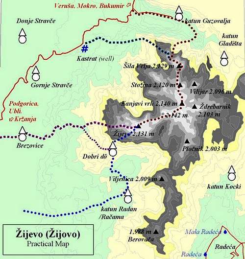
The most used paths to get to the summit are (see practical Map at the end of the page):
1. The SW Approach - from Krzanja village - over Brezovice settlement; this is the shortest climb to Zijevo that is marked or partially marked. (3-3:30 h walk)
2. The Northern Approach - from Kastrat well – this climb includes wonderful walk along the ridge. (3:30-4:30 h)
3. The Northern Approach from katun Guzovalja – includes a steep climb through thick woods and dry cauldron and after that a nice walk along the ridge. (3:30-4:30 h)
Getting There
 |
For Zijevo ascents the best way to get close to starting locations is by car. There are some bus connections from Podgorica, but only to get to the outskirts of Kucka krajina mountain Group, and then, to reach the foot of Zijevo you could continue by foot only or pick up transport from locals. No other kind of public transport does exist in the vicinity of Zijevo.
To get close to the wider area by plane
The most appropriate way to arrive by plane is to Podgorica airport. The airport still has no web-site so try to get info on the sites of two biggest airline companies that operate to and from Podgorica:
Montenegro Airlines
JAT – Yugoslav Airlines
Belgrade Airport - for flights between Podgorica and Belgrade and between Tivat and Belgrade.
There are also other possibilities to arrive by plane but it will take you more time to travel from there to Kucka krajina. They are Tivat Airport (Montenegro) and Dubrovnik Airport (Croatia).
To get close to the area by bus
The closest you can get by bus is to Orahovo - via Ubli (to approach Zijevo from south-east, via katun Korita and from south-west via Stravca/Krzanja) or to Verusa settlement (to approach Zijevo from north, via Mokro and Bukumirsko lake) .
Bus connection from Podgorica to Ubli and Orahovo 4-5 times a day (starting from=7:00, 10:30, 13:15, ..), maintained by "Minic" transport company, every day MON-SUN. Departure: Podgorica main Bus Station.
Bus connection from Podgorica to Verusa (via Lijeva Rijeka): 2 times a day at 07:00 and 14:20 h, maintained by "Minic - prjevoznicko preduzece" (read: Minitch) transport company, every day MON-SUN. Departure: Podgorica main Bus Station. Info at: ++381 81 621 923 (you are much in advantage if you understand local Slavic language).
There are no bus connections to the area from/to Kolasin.
To approach the foot of Zijevo mountain by car/bike or similar transport you can use next roads:
1. Podgorica – Ubli – Krzanja – Brezovice – for SW Zijevo approaches.
2. Podgorica - Ubli – Orahovo – katun Korita – Radeca - to approach Zijevo from SE.
3. Podgorica – Bioce (read: Bioche) – Lijeva Rijeka – Verusa (r: Verusha) – Mokro - Bukumirsko lake - katun Guzovalja - for northern Zijevo approaches mostly (via Sila mt.).
4. Podgorica – Bioce – Lijeva Rijeka – Verusa – Mokro - Bukumirsko lake - Kastrat well (Gornje Stravce) - for western and northern Zijevo approaches (via Sila mt.).
To approach the Group and summits by train
Very attractive Belgrade-Bar railway passes by western outskirts of Kucka krajina mountain group. There are more stations close to Kucka krajina, but except Podgorica you will have problem to find convenient public transport from those stations to Zijevo. All stations have 3-4 trains a day in each direction (north or south) and Podgorica and Kolasin even more, 6-9 per day.
The stations to choose are: Podgorica, Bioce, Seliste, Matesevo.
Best information on train schedules at:
Serbian Railways-homepage (search under „Passenger Traffic“, then „Train Sequence table – Stations Timetable, then choose your stations).
Serbian Railways-direct access to Station Timetable.
 |
Red Tape
Because of the vicinity of border with Albania, have your IDs with you. This warning would matter more if you plan to climb Zijevo from East (from slopes closer to the borderline). Recently, Montenegrin police has taken over border posts in the area from the military, but they left some of previous border-posts vacant, so if you visit the area these days you will not be able to see as many border patrols as you could do it before. It is also worth the effort if you visit a local police station (in Podgorica) before your trip to border areas and to report your future plans - especially if they are more comprehensive.The danger you must count on, is the fact that the mountain receives lots of precipitation throughout the year; it is treeless and therefore very exposed to atmospheric influences (winds, snow, and especially thunderstorms). The ground is not solid on many locations, so take care of crumbling rocks and theirs´ disintegration. Also, always take enough water with you!
 |
Camping and Accomodation
Like for the rest of Kucka krajina mountains GROUP, there are no mountain houses/huts or bivouacs in the area, also no official camping places. Even in wider area (up to 30 kms) you will not be able to find such objects at convenient distance.By state laws (like everywhere else in the world!) the camping is not allowed outside camping areas mostly because some would avoid to pay for prenotation, but this area is still remote and tourist-undeveloped that many laws simply have no sense here. So hikers very often put up their tents close to shepherds´ huts or small settlements. There are no special rules on camping. No one can stop you from puting it up, especially when you have no alternative to find another accommodation before night. But even if you camp in such "wild" way, please behave eco-consciously!
In case you need a shelter on higher grounds on Zijevo many times you will even have a problem to find appropriate place which is secure enough (from thunderstruck, wind), or even flat enough (!) to put up a tent. Sometimes, the most you can do is to hide under some of the cliffs, rocks or wholes.
Like for the most of mountains in the area, here too you can try to ask local shepherds for a sleeping place in their huts in nearby katuns (shepherds´seasonal settlements, clusters of huts). They are modest people, they will never try to profit from you, not even ask money from you, so don’t take advantage of them. An offer to pay for accommodation, even to give some sweets to their children would be very nice and I strongly recommend it to you. And especially from June to early September, there will always be some people on many of those katuns.
Katuns in the area around Zijevo, where you can still find some people in summer period are: katun Guzovalja (1,650 m), katun Radan, and Gornje Stravce and Brezovice (1,305 m) settlements.
Other accommodation possibilities (if you plan a day hikes) are in Podgorica or Kolasin area, and Podgorica (1 hour drive) is much better choice because of larger number of hotels/motels, while accommodation in Kolasin is less expensive.
When to Climb
 |
Other periods of year can be favorable, too. Despite the high altitude the area still lays close to the “Mediterranean Sun” and Mediterranean influence mix here with the continental one, thus giving lots of precipitation throughout a year, but sometimes easing sharpness of a mountain climate. Daily summer hikes can be hot – don’t forget the highest parts of Zijevo are completely treeless. Shades and shelters from sun, wind and rain are scarce.
The mountain is nice in winter too. But be aware of many chasms, crumbling rocks and avalanches.
Mountain Conditions
As the most important warning concerning the weather in the area: be very much aware of the danger of thunderstrucks and snow blizzards!! All of Prokletije mountain range and surrounding areas are well known for it! |
The nearest weather stations to the mountain are Podgorica, Kolasin, and Medjurijecje (in Moraca valley).
Podgorica meteo-station is in located in Zeta river valley which is very much open to Mediterranean influences, therefore the weather in Podgorica is many times better and much milder than in the nearby mountains as is Zijevo. But for the lower SW slopes of Zijevo, overlooking the city, Podgorica weather forecasts may be the best reference.
For weather conditions on Zijevo summit itself, Kolasin´s and Medjurjecje´s weather reports and forecasts can be many times more useful because any weather disturbance in this mountain area would probably influence both mentioned stations as well as the summit.
Since Zijevo is situated on the border between high Dinaric mountains and low laying river valleys close to warm Adriatic, for any Zijevo climb the best would be to check weather forecasts for all nearby weather stations (both mountain (Medjurijecje, Kolasin) as well as for low laying locations like Podgorica).
Weather information at:
Pogorica at Accuweather
Kolasin at Accuweather
Kolasin at MultiMap-5 days Forecast
Medjurijecje at Accuweather
Other local weather info (sorry they don´t have English pages) at:
Meteo-CG.
There are no live web-cams in the area to look at live weather situation.