Kučke planine (Kuči Mountains; Žijovo)

Kučke planine (Kuči Mountains; Žijovo)

Page Type Page Type: Area/Range
Location Lat/Lon: 42.57530°N / 19.55760°E
Additional Information Elevation: 7165 ft / 2184 m
Sign the Climber's Log

What´s new on this Page

4 April 16th, 2005 – Initial set up of the page
4 June 2nd, 2005 – Added link to new SP page: Maglič (Kučki)
4 November 1st, 2005 – Added link to new SP page: Surdup
4 May 24th, 2006 – Added link to new SP page: Žijevo (Žijovo)
4 July, 4th 2009. Žijovo - Kučke Planine, new similar page on the same mountain area added on SP.

Geographical Structure

Dinaric Alps 4 Central Belt 4 Površi i brda (Highlands and mountains) area of Montenegro 4 Kučke planine

Overview

Bukumir Lake (Bukumirsko jezero) in late June
Bukumirsko jezero (Bukumir lake), at 1,443 m

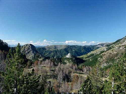
It is almost untouched, pristine, remote and quiet. Region called Kučka krajina or sometimes Žijovo («the Region of Kuči» – a Montenegrin clan) situated north-east of Podgorica the capital of Montenegro, next to the Albanian border, is one of not so known gems of the Montenegrin Dinarids.

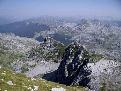
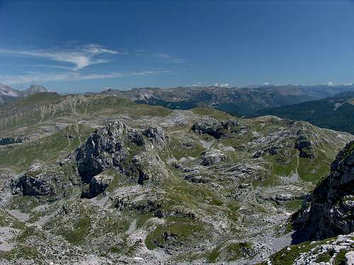
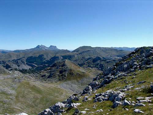
In fact this is a vast karstic plateau (povrs) from which more groups of summits, single mountain-like summits and mountains rise.
While some Montenegrin sources consider this group a western continutation of Prokletije mountain range (some Montenegrin Government papers even call them Kučke Prokletije, Prokletije of Kuči), because they share more similarities to neighbouring Malesija e Made and Prokletije/Bjeshet e Nemuna in Albania, the sources from other geographical schools and mountainering clubs, as well as old JNA (former Yugoslav National Army) maps keep the name Prokletije for central parts of Prokletije, only, namely to a montain range that stretch east of Cijevna river to Cakor mountain pass, not even counting NE extensions of the range over Hajla and Žlijeb mountains. Because of present status of three people-three opinions-three politics this page talks about Mountains of Kuči as a separate group, part of Montenegrin high karstic Povrsi i brda (High mountains and plateaus) region.


Along its western side, rivers of Moraca and Mala rijeka («Small river») and road Podgorica – Lijeva Rijeka – Verusa, make the limits of the area. River Cijevna and vast river valley of Zeta make south and southwerstern borderline of Kučka krajina (area of Kuči). To east, the area extends to the summits along Montenegrin-Albanian border and a smaller mountain ridge that enter into Albania (over Vermoshi) and finally, from the north side the first neighbour of Kučka krajina is Komovi mountain group.

Mountains of Kuči area are connected with ranges of central Prokletije at theirs´ northeastern side – starting east of Vila mountain and Rikavačko lake in Kučka krajina, and continuing over mountains of Vermosh in Albania and Maja e Grebenit (1,842 m) they meet Prokletije of Gusinje and Plav area (Trojan and Popadija) more to the east. On northern side Kuci mountains are connected to Komovi and Planinica-Mojan mountain ridge with another mountain ridge.

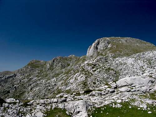
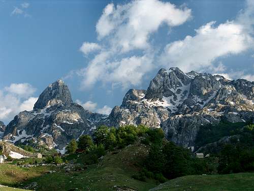
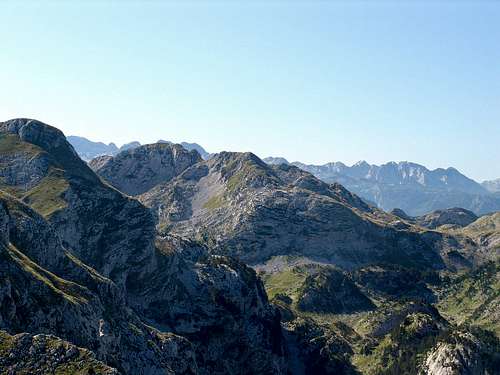
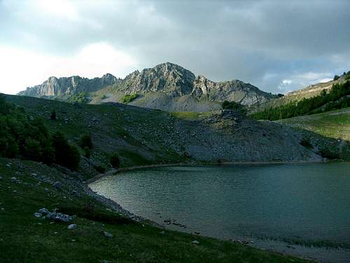
The physical features of Kučka Krajina Mountains show many traces of glaciation, as it is case for Prokletije mountain range. Also the relief of the group is very indented. Like the main part of Prokletije, which shape resulted from a colisiom between Dinaric and Sara-Pindus tectonic plates, the mountains in Kučka krajina too, deviate from usual Dinaric Alps´ NW-SE stretch and they stretch here in all directions – no dominant direction (see attached map – a chaotic disposition is visible there) .

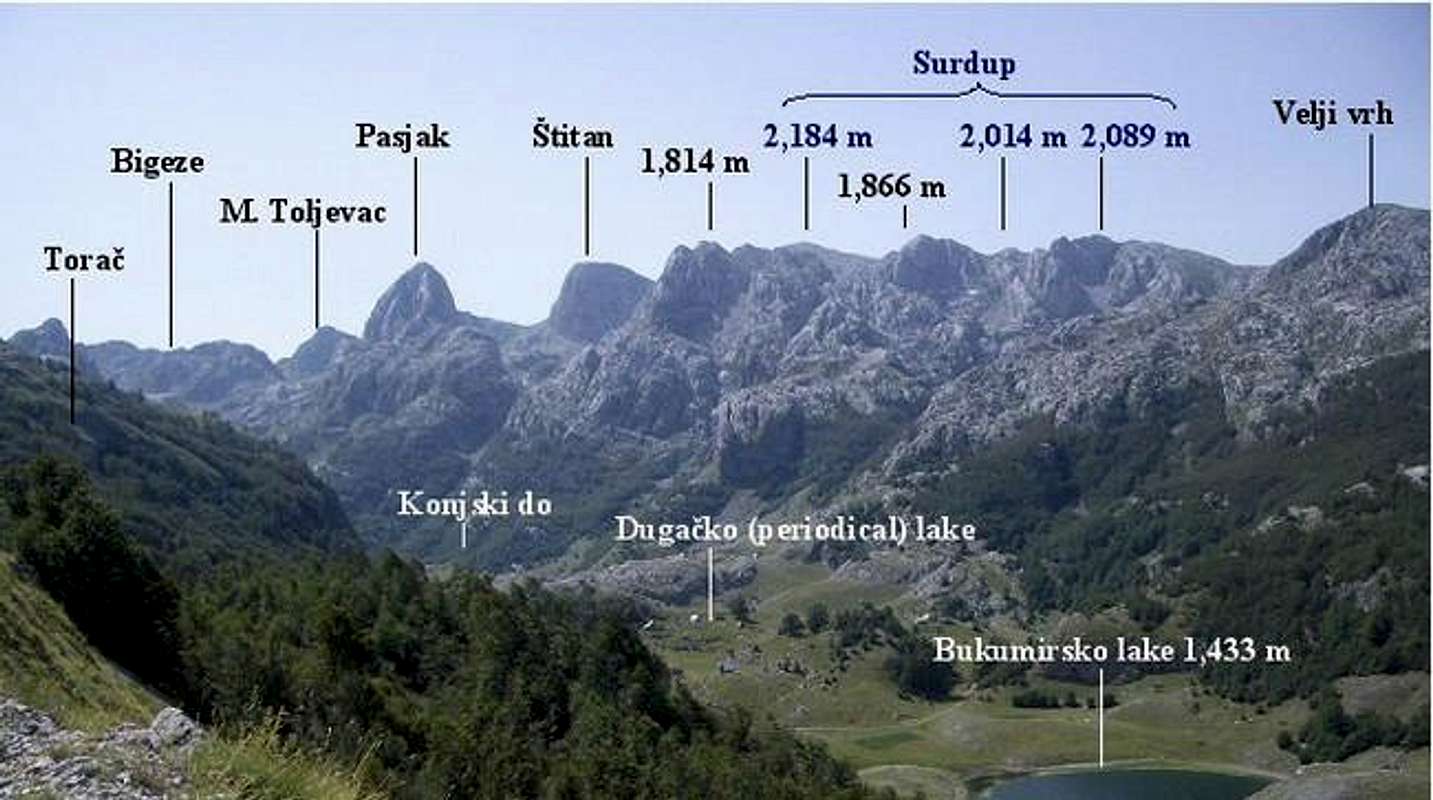
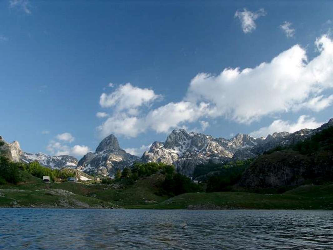
The highest summit of Kucka Krajina Mountains is Surdup with 2,184 m. There are more than 15 summits higher than 2,000 meters here. Because the mountains/summits rise from already elevated undulating plateau you will not always have feeling of such hight when looking the mountains of the region. But despite the false feeling of their real height they show a full high-mountain physionomy – sharp tops, glacial ridges, glacial chasms, lakes and valleys. The wide glacier that stretched over the plateau of Kucka krajina in the older geological period was up to 200 meters thick.

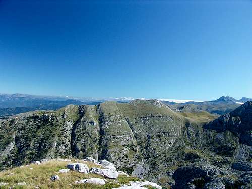
Only northern, and even more, the southern parts of Kučka krajina mountains have more woods. The most of the region is woodless, a magnificent mix of wild carstic and glacial structures and features combined with nice green grassy pastures.

On some maps and some literature the whole area is also called Žijovo or Žijevo (read: Zhijevo) after one mountain (area) in the region. Though, many writers are trying to standardize theirs´ name, by more often using the name Kučka krajina mountains / The mountains of Kučka Krajina, or simply Kuči mountains (Kučke planine)..

Still partly preserved stock-breeding tradition on these mountains give pastoral and picturesque image to the region. Katuns (“katun”, singular), small clusters of shepherds´mountain huts, can be found throughout the area, though in smaller numbers than before.

A practical map of the highest part of Kuči Mountains that is mostly visited by mountaineers

Practical Map of Kuči Mountains Group


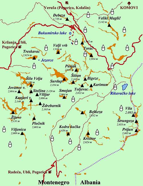
The Structure of the Group

Kucka krajina Mountains-subgroupsThe most recognisable groups/clusters of summits of Kucka Krajina Mountains are:

1. Central Cluster: Treskavac-Surdup-Stitan-Toljevac-Torac,

2. South-western Section: Zijevo and Sila,

3. South-eastern Section: Krisitor to Vila and summits along Montenegrin-Albanian border,

4. Northern Section: Maglic mountain (it is not the same mountain as the one on border of Montenegro and Bosnia&Herzegovina!)


Geomorphologically, the group can also include Albanian mountains north of river Cijevna (Albanian part of Vila, Prijun etc,...), and a branch south of Vermosh although these areas are even less known and less mountaineer-"exploited". I have included thas area as part of Southeastern Section of the GROUP.

Also, the area west of Central Cluster and Southeastern Sections in direction of river Mala rijeka and all the way to Moraca river canyon are by most divisions of Montenegrin mountains a kind of no-man´s-land, not described and not mentioned. This area is also not mountaineer-"exploited" and rarely is defined as a part of Kucka krajina mountain group, although geomorphologically it can fit into it. Untill someone else or myself define that area more precisely or establish some moutaineering highlights there, I shall leave it undescribed and not consider it as a separate section of Kucka krajina mountains GROUP.

Central Cluster


MOUNTAINS AND PEAKS OF CENTRAL CLUSTER

Surdup from south Surdup
The highest mountain in Kucka krajina group. Just as it´s first neighbor Stitan, Surdup´s summit is a wider grassy plateau from one side and steep cliffs on the other sides. Central postion makes it a nice view point, like all other peaks in the Central Cluster.
Peaks: Surdup summit 2,184 m, also other peaks along its mountain ridge, at: 2,104 m, 2,089 m, 2,052 m , 2,051 m.
Stitan
One of the most popular peaks to climb in Kucka krajina. Cone shaped. The summit area is a steep grassy plateau from the south and vertical cliffs from all other sides. Nice setting in the center of the group just as Surdup, its first NW neighbor.
Peak: Stitan 2,165 m
Pasjak as seen above Bukumir lakePasjak
Probably the most recognizable, it is a “sugarloaf”shaped structure,especially whenseeing from NW. The peak is an excellent viewpoint.
Peak: Pasjak 2,051 m
Treskavac from south, from Sila mt.Treskavac
Peaks: Treskavac 2,024 m
Smojan from westSmojan
Peaks: Vrh od Smojana 2,080 m - Obrucan 2,064 m
Both Toljevac peaks from StitanToljevac
Peaks: Veliki Toljevac 2,022 m - Mali Toljevac (…)
Pasjak and Bigeze from Surdup summitBigeze
Although without marked paths, with their amphiteatrical position they make nice background when climbing Stitan, Surdup and Pasjak.
Peaks: 1,988 m
Torac from katun LakovicaTorac
Peaks: Suvi Torac 1,882 m - Sirovi Torac 1,842 m
Debeza from Bukumir lakeDebeza
Read D in Debeza as j in jeep
Peaks: Debeza 1,755 m
Velji vrh peak from south, from SurdupVelji vrh
Peaks: Velji vrh 1,916 m
.Kariman
Peaks: Kariman 1,875 m
Planinica from Mokro-Ubli-Podgorica roadPlaninica (near Verusa)
Peaks: Planinica 1,566 m

Central Cluster of Kucka krajina mountains, with Bukumir lake below, seeing from north from Mokro-Stravca non-paved road


Panoramic photo of Central Cluster of Kucka krajina mountains


Shepherds settlement Širokar Lakovića on Kučka krajina mountains

South-Western Section


MOUNTAINS AND PEAKS OF THE SOUTH-WESTERN SECTION

Zijevo mountain ridgeZijevo (Zijovo)
Nice ascents and walks over Zijevo mountain ridges. Read as zhijevo (Z is like s in pleasure)
Peaks: Zijevo 2,131 m, also other nerby peaks at: 2,084 m, 2,057 m, 1,984 m
Sila Velja from southSila
Gentle slopes around summit. Summit is small plateau. Nice view on 3 km long, and all over 2,000 m high Surdup-Stitan massif in Central cluster. Read the name as «shila»
Peaks: Sila Velja (Djevojacki grob) 2,129 m, Sila Mala 2,022 m
Stozina from Sila veljaStozina
Peaks: Stozina 2,120 m
Kanjavi vrh from NWKanjavi vrh (crest)
Peaks: Kanjavi vrh 2,140 m
Zdrebarnik from SWZdrebarnik
Peaks: Zdrebarnik 2,103 m
Jovanov vrhJovanov vrh
Peaks: Jovanov vrh 2,084 m
.Plocnik
Read as plochnik (ch like ch in punch)
Peaks: Plocnik 2,003 m
Vilenica (Viljenica), eastern slopesViljenica
Peaks: Viljenica 2,009 m, Berovaca 1,988 m
Vilijar from westVilijar
Peaks: Vilijar 2,096 m
Hum oraovski, eastern sideHum oraovski
Peaks: Hum oraovski 1,834 m
Kozenik above katun KoritaKozenik
Read the name as Kozhenik. Some people aslo call it Kazenik and some maps note the peak as Kacenik (read as Kachenik). This is a somewhat solitaire peak, separated from the rest of the mountains and rising from a high plateau of katun Korita just north and above river Cijevna canyon
Peaks: Kozenik 1,650 m

South-Western Section as seen from the summit of Stitan (2,165 m)


Kucka Krajina, South-western Section

South-Eastern Section


MOUNTAINS AND PEAKS OF THE SOUTH-WESTERN SECTION

Vila fromNorthVila
Easy recognizable. Borderline passes over its summit, nice view of Albanian side and Central Prokletije.
Peaks: Vila 2,093 m
Vila and Strungeze from westStrungeze
Peak: Strungeza 2,053 m
.Prijun
Peaks: Prijun 2,005 m
Kristor and Central ProkletijeKrisitor
Its´ summit area is a green pasture. Nice views of Prokletije mountains especially on Albanian side.
Peaks: Krisitor 2,024 m
View on Beskeza from NWBeskeza
Peaks: 1,954 m (while a topo-map notes just one peak at 1,954 m, some other sources put one of its eastern summits to 2,032 m)
Prasica (Prosica) from katun RikavacPrasica (Prosica)
Peaks: Prasica (Prosica) 1,882 m
Kodra kucka from southKodra kucka
Peaks: Kodra kucka 1,858 m

South-Eastern Section as seen from the summit of Stitan.
Behind Kucka krajina mountains a wall of central area of Prokletije can be seen (Maja Jezerce is behind the summit of Prijun)


South-eastern Section as seen from the summit of Stitan

Northern Section


MOUNTAINS AND PEAKS OF NORTHERN SECTION

On Maglic (Kucki) mountain ridgeMaglic (Kucki)
Step-like physionomy with nice grassy plateaus and elongated mountain ridge (5 kms). Nicely positioned south of Komovi and on the northern edge of the whole Kucka mountains group. Very accessible, even by a non-paved road that passes nearby. Best access to Komovi mountains from the South. Mostly treeless with beautifull vistas all the way along.
Peaks: Veliki Maglic 2,142 m - Mali Maglic 2,060 m - Sovrh 1,915 m
Crna planina from the summit of Maglic (Kucki)Crna planina
Peaks: Suvovrh 1,911 m
...

Getting There

The best way to get close to the area is by car. You can also count on some bus connections from Podgorica only to get to the outskirts of the Group, and then to continue by foot or pick up transport from locals. No other public transport exist in other part s of the group.

To get close to the area by plane
The most appropriate way to arrive by plane is to Podgorica airport:. The airport stil has no web-site so try to get
info on the sites of two biggest airline companies that operate to and from Podgorica:
Montenegro Airlines
JAT – Yugoslav Airlines
Belgrade Airport - for flights between Podgorica and Belgrade and between Tivat and Belgrade.

There are also other possibilities to arrive by plane but it will take you more time to travel from there to Kucka krajina. They are Tivat Airport (Montenegro) and Dubrovnik Airport (Croatia).

To get close to the area by bus
The closest you can get by bus is to Verusa (northern/western approaches) and to Orahovo - via Ubli (western/southern approaches).

Bus connection from Podgorica to Verusa (via Lijeva Rijeka: 2 times a day at 07:00 and 14:20 h, maintained by "Minic - prjevoznicko preduzece" (read: Minitch) transport company, every day MON-SUN. Departure: Podgorica main Bus Station. Info at: ++381 81 621 923 (you are much in advantage if you understand local language).
Bus connection from Podgorica to Ubli and Orahovo 4-5 time a day (starting from=7:00, 10:30, 13:15, ..), maintained by "Minic" transport company, every day MON-SUN. Departure: Podgorica main Bus Station.
There are no bus connections from/to Kolasin.

To approach the Group and the summits by car/bike or other you can use next roads:
1. Podgorica – Bioce (Bioche) – Lijeva Rijeka – Verusa (Verusha) - for central, western and northern parts of the Group, mostly
2. Kolasin (Kolashin) or Andrijevica – Matesevo (Mateshevo) – Verusa - for central, western and northern parts of the Group
3. Podgorica – Ubli – Krzanja (Krzhanja) – Gornje Stravce (Gornje Stravche) – Bukumirsko lake- for central, western and northern parts of the Group, mostly
4. Podgorica - Ubli – Orahovo – Radeca (Radetcha) - for southern, eastern and central parts of the Group, mostly

To approach the Group and summits by train
Very attractive Belgrade-Bar railway passes by western outskirts of the Mountain group. There are more stations close to Kucka krajina, but except Podgorica you will have problem to find convenient public transport from those stations to Kucka krajina. All stations have 3-4 trains a day in each direction (north or south) and Podgorica and Kolasin even more, 6-9 per day.
The stationst to choose are: Podgorica, Bioce, Seliste, Matesevo.
Best information on train schedules at:
Serbian Railways-homepage (search under „Passenger Traffic“, then „Train Sequence table – Stations Timetable, then choose your stations).
Serbian Railways-direct access to Station Timetable.

Red Tape

No special red tape.
Because of the vicinity of border with Albania, have your IDs with you.
If you plan to hike for more than a day in the area have at least your tent with you.

When To Climb

Area between Torac and Sirokar
The area between Sirokar and ToracJune to September are the best months especially for multi-day hikes, because of nice weather and the presence of shepherds who live here over the summer, together with their live-stock. Other periods of year can be nice too. Despite the high altitude the Region lays close to the “mediteranean Sun” and mediteranean influence mix here with the continental one, thus giving lots of precipitation throughout a year, but also easing sharpness of a mountain climate. Daily summer hikes can be hot – don’t forget the area is very much treeless. Shades and shelters from sun, wind and rain are scarce on most of location.

Camping and Accomodation

Surdup´ mountain ridgeThere are no mountain houses/huts or bivouacs in the area, also no camping places. Even in wider area you will not be able to find such objects at convenient distance.

By state laws (like everywhere else in the world!) the camping is not allowed outside camping areas mostly because some would avoid to pay for prenotation, but this area is so remote and touristically undeveloped that many laws simply have no sense here. So hikers very often put up their tents by lakes in the area or close to the huts. There are no special rules on camping. No one can stop you from puting it up, especcially when you have no alternative to find another accomodation before night. But even if you camp on that "wild" way, BEHAVE ECO-CONSCIOUSLY!

Like for the most of Prokletije group, here too you can try to ask local shepherds for a sleeping place in their huts in Katuns. They are modest people, they will never try to profit from you, not even ask money from you, so don’t take advantage of them. An offer to pay for accommodation, even to give some sweets to their children would be very nice and I strongly recommend it to you. And especially from June to early September, there will always be some people on many of those Katuns.

Other accommodation possibilities (if you plan a day hikes) are in Podgorica or Kolasin area, and Podgorica is much better choice because of larger number of hotels/motels, while Kolasin has only one hotel (another one was/was not to open) but very cheap – cheaper than a hostel in Europe.

North of Maglic in Kucka krajina in Komovi area locals are very ready and accustomed to accept hikers in their huts or around them (Katuns Carine – just south of Komovi is very convenient because of its vicinity from Maglic).

NOTE (from spring 2006.) Mountaineering club "Komovi" from Podgorica has got for use a former border station from Montenegrin police in 2006. The Club plans to refurbish the building and open a new Mountain house here, the first in this area. The future Mountain house is located 35 km east od downtown Podgorica in Korita (Kucka-Hotska) settlement (SE edge od Kucka krajina mountain area, close to Albanian border), next to a new small church.

Mountain Conditions

Nearest weather stations to the Region are Kolasin, Podgorica and Medjurijecje (in Moraca valley). Since Podgorica is in Zeta river valley it is very much open to Mediteranen influences and the weather in Podgorica is many times better and much milder than in mountaineous areas. So Kolasin´s and Medjurjecje´s weather reports and forecasts can be more usefull to you.

Weather information at:
Kolasin at Accuweather
Kolasin at MultiMap-5 days Forecast
Pogorica at Accuweather
Medjurijecje at Accuweather

Other local weather info at:
Meteo-CG.
I was not able to find any live web-cam in the area to look at live weather situation.

Natural, cultural and other attractions

Lakes (find them on a map)

There are more lakes in the area, most of them of glacial origin. In late spring and early summer, after snow melting you will also find more small ponds, some of them natural some of them adapted for use by shepherds.


LAKES IN KUCKA KRAJINA MOUNTAINS

Bukumir Lake (Bukumirsko jezero)Bukumir lake (Bukumirsko jezero), alt. 1,443 m
This lake, together with central cluster of Mountains of Kucka krajina in the background make one of the most famous and most pictoresque scenes in the area. The lake is situated by the road from katun Mokro to Brskut or to Ubli, at 1,440 m above sea level. The lake is 210 m long, 130 m wide and 13-16 m deep. The length of the shore is 585 m, surface area is 1,982 sq m. The lake is of glacial origin. Its waters are home to abundant aquatic vegetation.
One of the most famous endemic inhabitant of this lake was a triton - a reptile known in hydro biological literature as tritus alpestis montenegrinus, which looks like a little crocodile.
Situated around the lake is katun Jezera and nearby katun Popovica.
The lake is popular especially in summer as an ad-hoc camping place, or nice place to refresh by swimming in its waters.
Northern side of the lake is rocky, while southern one is more gentle and covered with vegetation.
Lake is also used as a watering place for livestock in summer.
Water of the lake is clear and transparent - visibility up to 4 meters deep.
Dugacko periodical lakeLong or Small Bukumir lake (Dugacko jezero/Malo Bukumirsko
Next to Bukumirsko, 5-10 minutes walk away from it. Dugacko lake (read: Dugachko) is also called “Malo” (Small) Bukumirsko jezero, it is a periodical pond, 200 m long, next to Ivanovica (family) huts in katun Jezero. The lake is present here during times of abundance of water, especcially after snow melting. Then in early summer it dries out.
Rikavac lake (Rikavacko jezero)Rikavac lake (Rikavacko jezero), alt. 1,313 m
It is the largest lake in mountains of Kucka krajina group, 525 m long, 230 wide and 14 m deep. It is situated between Sirokar area (read: Shirokar) which is a pass/plateau where katun Sirokar Ljakovica (1,765 m, read: Lyakovitcha) is situated, and Vila mountain (2, 093 m). Water torrents from surrounding mountains bring lots of water but also lots of land material into deep where the lake is situated and into the lake itself so Rikavacko lake is becoming shalower each year.
The lake is predominantly of glacial origin but there were also some tectonic influences present in its shaping.
It is accessible in 30 minutes by steep road from Sirokar Ljakovica or from the south from katun Korita.
Next to the lake is katun Rikavac (1,403 m). The lake is very close to Albanian border – just few hundred meters away from it.
People do fishing here too (trout).
Jezerce lake or Guzovalj lakeJezerce or Guzovalj lake, alt. 1,867 m
This lake better say a pond is situated between Treskavac and Surdup mountains. The exact location of this pond is Jezerce high valley and plateau at 1,867 m north of Treskavac pass (Cafa od Treskavca). This plateau there is a spring and Jezerce pond, where endemic tritons live. This site is one of beginning points (cirk) where from glaciers descend from the mountains by valleys, to the east in directin of Bukumirsko lake and to the west to Bljusturni (read: Blyushturni) do (field).
.Nenze (Neuze) lake
This is very small, beautifull, permanent lake, situated SW from Rikavacko lake under Prasica (Prosica) carstic plateau, accessible by a trail leating to Vila summit and Studenica katun.


Rivers


MAJOR RIVERS IN THE VICINITY OF KUCKA KRAJINA MOUNTAINS

River Cijevna canyonCijevna river and canyon
River Cijevna (Cem, Cemni in Albanian) is left tributary to Morača river. The spring of Cijevna is located west of Trojan mt. (2,183 m) in Proletije mt. range, and the river flows from there in SW direction as Cem Selcit through Malësi e Madhe region in Northern Albania. After Cijevna reaches the border of Montenegro, and finally enters Montenegro south of Suka Mizdrakut (1,144 m) mt. it forms a canyon with high and steep sides. As the river flows more to the west the canyon becomes wider and its sides lower until Cijevna enters Zeta plain close to Dinoša settlement few kilometers SE of Podgorica the capital of Montenegro. From here another very attractive part begins, as Cijevna had carved its course in low laying horizontal rock slabs in Zeta plain (Ćemovsko polje-field) thus forming a miniature canyon, a kind of half-opened natural tube (and really, in local language the noun cijev stands for english tube and this may be the explantion for the origin of the river name). Despite the fact that Zeta plain is very (very) hot place in summer Cijevna river stays very cold all year round. For the most of its length its water is drinkable.
.Mala rijeka canyonMala rijeka
Mala rijeka is a left tributary to Morača river (flowing into Moraca in the village of Bioče). “Mala rijeka“ means „Small river“. For the most of its lenght its river bed is a canyon straitened between Vjetrenik mountain (west side) and Kučka krajina Mountains (east side). While upper parts of its river bed receive a lot of fresh water from the mountains in the area of Vasojevići clan (area around Komovi mountains, north of Kuči region), the lower parts of Mala rijeka dries out in summer and waters flow underground below surface. In spring during snow melting Mala rijeka usually brings very strong torrential waters to Morača river. The river and spring waters in the area are very cold, measuring 5°C, at average.
Western sides of Mala rijeka around Vjetrenik mountain belong to Bratonožići clan, another of Montenegrin clans. This is one of the most underdeveloped parts of Montenegro, mostly because of difficult rocky terrain not suitable for agriculture. Such conditions make life very hard for local people. In this area, alongside Mala rijeka canyon passed an old road from Zeta valley inland, for long time the only major connection from Montenegro to Sandžak (Sandjak) area, Kosovo and central Serbia.


Settlements and other locations

Veruša (1,010 m)
After 50 kilometers by road from Podgorica in direction of Mateševo and Kolašin (via Bioče and Lijeva Rijeka) you reach Veruša (read: Verusha), the most popular starting point for Kučka krajina mountains, because of easy access. Veruša today is mostly a week-end settlement of the citizens of Podgorica. It is very picturesque and peacefull place, at the western end of a valley which can take you into central, northern and eastern parts of Kučka krajina mountains. Fishing in the area on rivers Veruša, Opasanica and Tara (brook trout).

Belgrade-Bar Railway

This is one of the main attractions on western slopes of Kucka krajina mountains. This 476 kms long railway connects Belgrade, the capital of Serbia with Bar the largest port in Montenegro. And out of totally 476 kilometers, 175 km pass through Montenegro. It was probably one of the most difficult railways in Europe to build. The railway is mostly highland/mountainous in character, especcially its Montenegrin section. Nearly 25% of totall railway´s length are tunnels and bridges!
It took 25 years to build it - starting from the year 1952. untill the first train passed through in 1976.
Montenegrin section of railway has 105 tunnels (totally 43 kms) and 93 bridges (totally 7 kms)!! Because of such features people wittily call this railway a „Montenegrin subway“!
This is very much true, especcially when someone observes very difficult part of railway just above Moraca river valley at the western edge of Kucka krajina mountains, on section from Kolashin to Bioche. It is often said that the railway doesnt go on surface here, but instead of it, it goes either underground (tunnels) or though the air (bridges). On this section 40 kms long there are 54 tunnnels – that are almost 24 kms long! Travelling by train you can experience astonishing views of Moracha canyon in Lutovske Platije (steep rocky cliffs above Moracha river canyon).

And in mountains of Kuchi region, 20 kilometers north of Podgorica, there is a famous railway bridge that passes over Mala rijeka (river). Travelling by train you approach this bridge by exiting a tunnel and after you pass the bridge´s 499 meters of length you enter another tunnel again.
This viaduct is the highest railway bridge in Europe (I dont have recent info if any other bridge is higher than this one…) its rail level standing 200 meters above the Mala rijeka river level. Because of strong winds that can blow here the traffic on the bridge is also secured by a strong steel net. The base of central column of the bridge is larger than a tennis court. Nice view of the bridge can be seen from the village of Klopot on the Bioche-Mateshevo road.

More Photos

Maps


Children

Children

Children refers to the set of objects that logically fall under a given object. For example, the Aconcagua mountain page is a child of the 'Aconcagua Group' and the 'Seven Summits.' The Aconcagua mountain itself has many routes, photos, and trip reports as children.