The Adventure Begins – Day 1 & 2 (20th and 21st Dec’ 2007)
Bidding goodbye to my wife, I flew out of College Station for a connecting flight from Houston to Mexico City. It felt good to meet up with Rakesh Thakare (Rakya), my long-time climbing partner who had flown in from Cleveland, Ohio. The crew for our flight had not arrived, as a consequence of which, instead of 9 pm, our flight took off around 11:15 pm, dropping us off at the Benito Juarez Airport of Ciudad de Mexico at an odd time of 1:30 am. Now, this was the time when I was going to try out whatever Spanish I had learnt by utilizing the 4-hour-per-week driving time from Houston to College Station (for about 6 weeks). We got some dollars exchanged for Pesos, at a rate of 10.65 per dollar. Stammering with whatever words I knew, we got ourselves directed towards the second floor, and started walking towards the “Ground transportation” sign. “Estrella Roja” means “Red Star” is a fantastic bus service, which picks you up from the airport, so you don’t have to think of taking a taxi, and trying to reach the bus station in the city. Now, when we both saw the prices, we almost got a heart attack! In Mexico, they openly use the “$” sign, even for their own currency. The ticket to Puebla was $170, which actually means 170 pesos. The first bus out of the airport was at 6 am, so we had to sleepily spend the next 4 hours somewhere. Fortunately, the bus service has maintained a good rest area,
![Another view of the rest area]()
where you can relax on sofas. Kirk, a fellow SP-er from NY was going to join us on this climb, but we hadn’t heard from him. So, Rakya tried calling him at the hotel number he had provided, but we couldn’t get a hold of him. Later, in the small internet area provided by the bus service company, Rakya checked his email and learnt that he had missed his connecting flight to Mexico City. I and Rakya tried our hand at sleeping on the sofas, but were constantly woken up by other people passing by. 6 am – we board the fantastically built-much-better-than-an-airplane bus at the airport, and we leave for Puebla (Climbers need to make sure that they buy a ticket to CAPU bus station, and not 4-point in Puebla). On way to Puebla, we had fantastic views of Izta and Popo, the other two high volcanoes in Mexico. It is not allowed to climb Popo, due to recent volcanic activity, but a lot of people climb Izta. The Spanish movie on the TV did not make much sense, but the music was kind of nice, and we both caught up on some sleep, only to be awakened by people at the Puebla bus station, knocking on the window, offering their help to unload our backpacks and carry them, to wherever we were going. We both got down in a hurry, to make sure all our stuff is still there, and politely refused help. Now, the next aim of our journey was to find a bus heading towards the small town of Tlachichuca, at the base of Pico de Orizaba. With the help of sign language, and whatever Spanish I could piece together (here, I was eternally thankful to my parents who took immense pains to instill in me, a sense to pick up a language – in other words, being a son of “language-background-parents” helped) we made our way to a huge central place (for future climbers, take the overhead covered bridge connecting the “ER” side of terminal to the “AU” side of terminal), where hoards of bus companies had set up shop, for people to travel to all parts of Mexico. We were on the lookout for “AU” Bus Company. The lady at the counter ticketed us at the rate of 38 pesos per person, and waved her hand in a direction where we had to board the bus (obviously coupled with direction in extremely FAST Spanish). With a backpack each on both sides of my body, and a carry-on luggage in the hand, we both were trying to find the gate
![Gate at Puebla Station]()
![Schedule]()
for about half-an-hour (to the amusement of probably everybody at the bus station, who were staring at us, as if we were aliens). During this time, we both walked the entire length of the “AU” bus service gates, trying to find “Tlachichuca” on any one sign, amidst all kinds of names we sometimes couldn’t even pronounce. Finally, found the gate, which happened to be the second-last one, where relatively fewer passengers waited to board the bus (Climbers, this gate was the one next to the restrooms at the far end of the pathway with gates on it). We were amazed to see the bus driver cross check our tickets by punching something on the “keyboard-type-of-thing” in front of him, which spitted out a receipt for us both. Even the buses (which happened to be Mercedes-Benz make) going to far-flung places had technology built-in. Be sure to load your luggage in the bus’s belly yourself (Rakya did this)
![Rakya loading the sacks]()
, unlike in “ER”, where they do it for you. We lost some time on the road, as there was a big accident. Unlike US, and very much like India (where I come from), the driver opened the door of the bus for passengers to go out, feed on their curiosity, and make the clichéd-and-utterly-obvious discussion on “What happened? How big is the accident?
![Accident]()
How much time will it be before we leave? AND a final – Why is THIS happening to US?” Two considerate gentlemen (in a totally uncaring and obvious “who cares?” manner) even washed part of tires of the truck in front of us giving vent to nature’s call. In the meanwhile we could see Pico de Orizaba in the far distance. The sheer height of the mountain dwarfed everything in its vicinity. The accident cleared, and our bus rattled its way through small towns (where you have to constantly check if your luggage is still in the bus, as people keep on boarding and leaving the bus, and the driver keeps on opening the bus-belly. At Tlachichuca, Senor Canchola and Senor Reyes happen to be two of the main organizers for the climber’s community who come to this town for Orizaba. A lady walked us to Senor Canchola’s house
![Senor Canchola s House Entrance]()
(a 10-min walk from the bus stop). Inside, Maribel greeted us in English (she can speak a little bit of English, which is helpful). After a hearty meal at her place, followed by a thorough check-up of the gear, we were dropped off at the Piedra Grande hut by Senor Canchola himself in his distinct yellow colored Jeep. I would define the two-hour ride to the hut as “THE ULTIMATE road test for ANY 4x4 vehicle”. We felt that the municipal council / corporation of Tlachichuca can earn a lot of business if they “rent-out” the trail to all 4x4 manufacturing companies.
Feeling Like Crap – Day 3 (22nd Dec’ 2007)
Our original plan was to leave for high camp on day 1 itself, and establish the campsite, with an even more (over) ambitious and optimistic plan of attempting the summit on Day 2. But, once we reached the hut at about 4:30 pm on day 1, we decided to move to the next elevation the following day. We did take a casual hike above the hut, to follow the “climbs high, sleep low” philosophy.
On day 2, we left in the morning for setting up high camp. Once you pass Campsite 1 and 2,
the third (this is what is called high camp) campsite is about 45 minutes away (depending on your speed). But, you do need crampons after campsite 2. We reached the high camp at around 2:30 pm, and set up camp. The altimeter on Rakya’s watch was showing 15,300 feet. As soon as we set up camp, we drank some soup, and had some “lunner”, a combination of lunch and dinner.
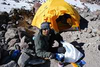
![Cooking]()
Inside the tents, both of us actually felt like crap. We had severe headaches, didn’t feel like eating or drinking, just felt like sleeping – all the symptoms of AMS. We did try to not get inside the sleeping bags, and stay as much outside the tent as possible, so that our bodies acclimatize. But, nothing seemed to be working. A group we had met on the way to Tlachichuca, in the bus, was going to hike up all the way up from the hut to the tip of the glacier, for acclimatization. They greeted us on the way back, at about 4 pm. Finally, in the state of “feeling utterly crappy”, we both went to sleep at about 7 pm, in conclusion that we will get up around 3 am to decide whether to go for the summit or not. The next day was supposed to be the summit attempt day.
(Supposedly) Summit Attempt Day – Day 4 (23rd Dec’ 2007)
4 am in the morning – we both hear voices outside our tent going past towards the summit. A voice from my sleeping bag went out to Rakya – “Rakya, what do you say, should we go for the summit?” A rather stupid question on which almost all climbers would laugh, as we had hardly prepared our backpacks (leave alone our minds) for the summit. A voice from the other sleeping bag said, “Let’s sleep right now and will go for it tomorrow”. And, we woke up at 8 am, with the tent glowing bright yellow because of the sunshine.
I crept out of the tent, and walked around the campsite, ignoring the breezy but warm morning. About an hour or two later, I woke up Rakya. Again, a cup of coffee, Maggi noodles constituted of our breakfast. We were running out of water, so we had to put on crampons to go get some snow in a trash-bag. The jetboil stove system Rakya had took quite a while to melt the snow to fill up 3-litres of water bottles.
![Melting Ice]()
A couple (Chad and Christi) from Fairbanks, Alaska met us on their way down. They gave us some tips on what all to observe while climbing, and descending (I will illustrate them at the end of this TR). After a quick lunch of Sante Fe Chicken and Rice (the one you get in REI, and the kind we both were getting nauseated with) I decided to hike up a little, and explore the route we were going to take the next day for the summit. I was feeling fine, but Rakya’s headache was still prevalent, so he decided against going up for a height gain. I thought of going up to the tip of the glacier, but just before I was going to top off the labyrinth, clouds started forming and coming in,
![Clouded]()
eventually forcing me to descend. I reached the camp, spent some time outside, before going inside the tent, to make sure I was ready for the next day. Once I started packing for the next day’s summit attempt, Rakya declared what I feared – that he won’t be attempting the summit the next day. There were two plain facts – his headache was still there, and Pico de Orizaba was there to stay. The idea of climbing by myself, all alone dawned on me, and I began thinking of whether I will make it or not. With all kinds of thoughts in my mind, I and my restless mind went to bed. I took Rakya’s watch, on which I set up an alarm for 2 am.
Me and the Mountain – THE Summit Attempt Day – Day 5 (Dec 24th’ 2007)
Although I contend that I never ever heard the alarm, I woke up at 2:10 am, and immediately started making some coffee. The coffee was followed by forcing Maggi noodles down the throat, followed by about half-an-hour of getting ready. As usual, it was so hard to get the crampons on, with the gloves on. With the headlamp set on the trail, I started climbing at about 3 am. The labyrinth is not something very difficult to tackle, but at some junctures, the trail (footprints and crampon-marks) split, so you have to make a conscious decision as to which way you want to head. Following the tips from the couple from Alaska, I took the one on the right. On some sections, it was so icy that the ice axe had issues going in, neither would the crampons. The crampons teeth actually slipped off the moonlit-and-shiny surface of the ice. It was here, when I suddenly felt all alone, by myself, not roped-up and exposed to the slope which was visible from between my own feet. After I topped off the labyrinth, I decided to take a break, and eat and drink some, to re-energize myself. To my horror, the water in the hydration sack had frozen, and all I had was two small bottles of mango drink. I finished one, along with half a cliff bar. I could see the summit with about 2800 feet separating us. I turned right towards the gully that takes you to the tip of the main glacier. Meanwhile, the group that started from the hut joined me, and we all took a break. The sun was rising on the horizon,
![Pico de Orizaba, at Sunrise]()
and it was one of the most spectacular sunrises I have ever seen in my life. This was the time for getting your goggles out, putting on some sunscreen, and continuing with the climb. I did the “taking-out-goggles” part, after which, just couldn’t wear the gloves. Neil, the group leader / guide amongst the other group helped me. Their group overtook me, and I was by myself. I tried keeping up with their pace, but the lack of water as an energy source just wasn’t helping. I must admit, that it was about 2-3 times that I thought of giving up the summit, and returning to the campsite. But, again, I told myself – This is IT or it is never! I have come all the way from the US to scale this peak, and if I turn back now, I don’t know when I will be able to return back. So, pushing myself mentally, I carried on. Although I had promised myself that I won’t allow the group in front of me to go out of sight, I could see the group topping off at the summit rim and disappearing in front of me. Now, there was me and the mountain. After a while, two things happened – one, I saw clouds coming in at a rapid pace, and two – I saw the group descending from the summit rim.
I – “How much more is left for the summit? Is that rim the summit?”
The lead guy – “No Dude, you still have about 500 vertical feet to go. Once you top off on the rim, you have about 200 feet to circle on the rim before you reach the summit. You got to take a compass reading. The clouds are coming in. By the time you come down, it will be a complete whiteout. How are you going to find your way down?”
I – “I think I will trust my sense of direction”.
The lead guy – “I have a spare compass, if you would like to borrow”
I – “Its no use. I don’t know how to use one. I think I will be fine.”
I am pretty sure that the conversation must have left them speechless. They must be thinking – “How the hell does he NOT know how to use a compass???, and how is he going to make it down???”
I reached the rim, circled it, and summitted Pico de Orizaba at about 11: 30 am.
And this was the time, when the water in my hydration sack un-froze and started flowing. In all, it took me a total of 8 hours to reach the top. It was a problem for me to take a photo of myself with the Indian flag, so had to take one by keeping it on the backpack. A quick clicking sequence,
![Summitted at 11:30 am]()
and a couple of bites of cheese, chocolates, and water later, I was heading down the rim. The clouds were already in, but I guess, god was listening to my prayers, by helping the sun peek in, once in a while. It felt as if the sun and the clouds were competing or actually playing a game of hide and seek, and I was benefiting from it. I was about to lose my way twice in the glacier, but thankfully, got back on the trail, once the clouds cleared. I couldn’t help but think of sliding down the glacier on my butt. This could have definitely saved me some time, but being all by myself, I decided against taking that risk (and also, had not read of anybody on SP ever glissading down the glacier on this mountain). After descending the same gully I had ascended in the morning, I reached a point at the top of the labyrinth, where I wished I had planted flags for times like these. Believe me, it was so confusing, as to which way to descend, that I actually spent half-an hour navigating my vision through the boulders. Finally, with the sun behind the mountain, clouds caving in, temperature dropping, I decided on a trail, and started descending. But, I must admit I wasted some precious time there. Once at the tent, I saw that Rakya had taken the fly with him, and left the tent and the poles, along with my stuff, for me to pack-up and carry to the hut below. At the campsite, I sat down, doing nothing, for about 15 minutes. I was so exhausted that, when I started packing, it took me almost half an hour to pack my sleeping bag. To worsen matters, it started to snow. After my personal packing was done, I packed the tent, trying to shove off the flurries of snow as much as possible, and left for the Piedra Grande hut. Because of the snowfall, everything was white, and it was kind of hard to look for the trail. Passing campsite 2 and campsite 1, I saw a few tents, which I guessed were empty. Once I saw the hut, I felt relieved. It felt pretty good that I had not fallen / slipped even a single time. This changed the moment I stepped foot on the concrete that leads the way to the hut. All I saw was two of my feet in the air, in front of my eyes, and I landed on my ass. I hit my left wrist so hard, that for a moment I thought I had fractured it. Limping along the trail, I reached the hut, where I was greeted by Kirk (my first SP-er meeting),
![SP-er]()
who was supposed to join us on the climb (he missed his connecting flight to Mexico City). And then I witnessed a rare species – an Indian female (she was a Punjabi) along with her buddies. Very few Indians enjoy mountaineering activities, and on top of it, an Indian female is all the more rare. She offered some rice, which I could hardly eat. The liter of hot water provided by Kirk really helped. I learnt that Rakya had left for Tlachichuca in the afternoon. This news killed whatever enthusiasm I had of eating a good meal, and sleeping in a nice bed at Senor Canchola’s house. Again, the sleeping bag came out, and I had to sleep over the wet sleeping mat, which I had attached to the outside of the backpack. The next day, when I saw the yellow 4x4 arriving towards the hut,
I was relieved.
A Dedication
All my family members and my wife’s family members from India, my friends, my wife, everybody was constantly telling me not to go to the Orizaba climb, as my wife is pregnant and we both are expecting a third member in June. How can you leave her and go like this – was everybody’s question for me. All I could say was – keep faith in me. I know what I am doing, and believe me – I am also concerned about me, my wife, and all I ask of you is – trust me.
They did, I went, I climbed, and I came back safe and sound, although I must admit that at places it got a little risky. I could get through those by keeping calm, focusing on the slope I faced, thinking of my wife (who had warned me y saying, “If, at any juncture, you feel that it is not safe to go ahead, promise me that you won’t, and return back from there) and praying to god. Because of my family’s trust in me, I dedicate this climb to all of them, especially to the unarrived member.
Now it will be a while before I plan my next big climb, with a certain hope that all three of us make it to the next climb.
Some Helpful Tips:
On the route:
• Once you go up about 500 – 600 feet from the hut, about half an hour from the hut, you see a well-built short embankment, made of rocks. Here, the trail diverges to the left as well as right. And to everybody’s surprise, there are cairns kept on both the sides. Be sure to take the trail on the right, as it will take you to campsite 1, 2 and high camp.
• After the third (high) camp, once you get into the labyrinth, there are about 2 places, where again, the trail diverges. Here also, make sure you take the one on the right. One won’t get terribly misled if one takes the left trail, but it will take you to a point farther away form the tip of the glacier that you ascend for the summit.
• Once you reach the top of the labyrinth, you see the rim of the volcano at approximately 1 o’clock (spatial orientation). Make sure you start moving towards 3 o’clock (which has about 2-3 gullies, which takes you to the base of the glacier). Again, if one starts going straight in 12 o’clock direction after topping off the labyrinth, one can surely climb the peak, but it gets a bit steeper towards the end.
• Once on the glacier, try to look out for footsteps from the previous climbers, which are sure to give you a sense of direction, while going up. You don’t want to end up on the other side of the mountain, where I have read that the gradient is pretty steep.
Some terms in Spanish:
Although I know that there are a lot of books / CD’s / tapes available out there, via which one can learn basic Spanish, but, I felt I should put down a few commonly used terms which would help an amateur in Mexico (like me). Native Spanish speakers – pardon me, if I err somewhere, and do make the necessary changes in the statements.
• Hola – Hello / Hi
• Como esta usted – How are you?
• Si – Yes
• Mañana – Tomorrow
• Aquí – Here
• Mui Bien – I am fine; y tu? – And you?
• Gracias – Thanks
• Desayuno – Breakfast
• Almuerzo – Lunch
• Comida – Dinner / Food
• Que Hace Tiempo – How is the weather?
• Hace Frio – Weather is cold
• Mi cuenta – How much?
• Uno, Dos, Tres, Cuatro, Cinco, Seis, Siete, Ocho, Nueve, Diez – One to Ten
• Senor – Sir; Senora – Madam; Senorita – Miss
• Habla usted espanol (ingles)? – Do you speak Spanish (English)?
• Yo hablo un poco espanol? – I speak a little Spanish
• Sal – Salt; Pimienta – Black pepper
• Buenos Dias, Tardes, Noches – Good Day, Afternoon, Night
Additional Information for the hotel is as follows:
Location: -Tlachichuca, MX. The hotel is nothing but a few rooms built within the compound of Mr. Canchola, and his daughter, Maribel Canchola. They both are very helpful.
Phone Number: 011 52 245 45 15082
Address:
Av. 3 Poniente No. 3.
C.P. 75050
This is nothing but a 10 minute walk from the bus stand where the bus will drop you off.
Charge: For the transportation from and to the Piedra Grande hut, she charged us $175 per person. She prefers this amount in USD, but she can also accept pesos. Also, the food, lodging and the equipment we took from her (gas, water etc), all costed about $70 per person. We were there about 2 nights, and had about 2-3 meals, which were pretty delicious.
Email Address: cancholashouse@yahoo.com.mx


Comments
Post a Comment