El Pico De Orizaba / Iztaccihuatl- Normal Routes
February 2nd to February 7th 2009
One of the great things about a trip like this is the minimal planning
required and the relatively inexpensive costs. I was excited to learn
about the Mexican volcanoes and the fact that these are the 3rd and 7th highest
peaks in North America, yet highly accessible and doable in a day, each. We
decided that the priority peak would be Orizaba, so we would go for that one
first, despite that fact that many do Itza first, as an acclimatization climb.
We also came fully prepared with ropes, harnesses, crevasse rescue setup,
cramp-ons and ice-ax just in case. It was still a long way to come to not be
fully prepared for all conditions. When it was all said and done we used nothing
but the ice-ax and cramp-ons. The biggest factors that made this trip so enjoyable was the fact that the people were so helpful and nice,
and the fact that we hired a full time driver (Rogelio Garay). Even with the
added cost of a driver, this is about the cheapest international (from a U.S.
perspective) mountain climb that can be done.
![Itza summit]()
Day 1
The flight down from Boise to Mexico City via Phoenix wasn't bad at all,
especially compared to the previous years flight to Argentina. We planned to
stay at Servimont in Tlachichuca, Puebla and had a driver pick us up at the
airport and take us directly to Servimont. The alternative was to catch a series
of buses to get there that would have added about 1 extra day to the trip,
each way. The driver took us out of the massive Mexico City and east onto a
freeway. Later we would speak with 2 young Swiss climbers that told us they got
pulled over in their rental car just outside the airport and the police officer
gave them a choice of handing over 1300 pesos, or the vehicle. We left
Mexico City at 7349 feet above sea level and traveled over a 10,000+ foot pass
and then back down to Tlachichuca at 9000 feet where we would spend our first
night.
Day 2
Servimont is an amazing compound-like enclosure sitting in Tlachichuca that
you would never know exists. It's closed off from the rest of the city by high
plain walls and a secured gate. Once inside, several buildings and garages exist
from 1800's. We stayed in the traditional climbers area- a converted old
Soap Factory that had a lot of charm and history associated with it. Much to our
delight we were the only ones staying, and we met the owner Senor Reyes who is a
very accomplished climber and business man. He was extremely helpful, as was his
whole staff. He also advised us of the current conditions on the mountain which
happened to be very favorable. Given that we were the only ones there (Feb is
toward the end of the climbing season) we were able to tell the cook staff when
we wanted to eat and the drivers when we wanted to go places!
![Itza summit crater glacier]()
We headed up to the Sierra Piedra hut at around 10am and sat in the back of
a pickup truck (Covered and padded). The going was bumpy, but it wasn't too
bad. We stopped at several small towns on the way up. One small town sat at over
11,000 feet. At 12,000 feet there were rows of crops. We
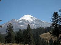
reached the hut, which sits on the north side of Orizaba, and had our first view
of the highest peak in Mexico. There were several climbers finishing up and
packing to leave. Soon enough, it was only us and 2 Swiss climbers in the hut
for the night. The hut sleeps up to 60, but that would be very tight. After
arranging gear I took an acclimatization hike from 14,000 feet (hut) to 15,300
just below a section called the Labyrinth. The weather was windy and
partly sunny (50F).
Day 3
I had read that many groups start at 1 am or 2 am to climb in ideal
conditions and beat any afternoon weather. If I was to do it again I would have
probably waited until 4-5am, but to be sure, I awoke and got going by 3:30am
after learning that my partner did not feel well. The Swiss climbers left just
after me and caught up to me 2 hours later at around 16,000 feet. I made my way
through the dark and even though it was marked and cairned fairly well, I was
glad I took the acclimatization hike the day before to familiarize myself with the
beginning of the route. Below the Jamapa Glacier there's a short steep
section that goes up a rock slot. Near here I put on my cramp-ons, and made my
way up the steepest section of the route. Once on the Jampa Glacier, it was just a
steady and steep slog up the north side of this massive volcano. There was
no real climbers trail once on the glacier, so it was basically just up and up.
While on the glacier the sun came up to the east over the Gulf of Mexico and it
was spectacular. It was cold, but not cold enough to warrant the Down jacket for
me. Just ahead one of the Swiss climbers was continually shaking out his foot. I
would later learn he had a little frost nip on his toes.
![Evening on Itza]()
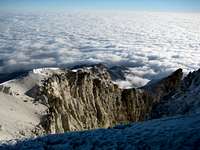
After nearly 2000 feet of straight up the glacier, I reached the crater rim at
about 18,000 feet. Once onto the west rim The sun shined brightly on me as I
reached the summit. Amazingly it was windless and warm after a pretty chilly
north side climb. I looked into the massive opening of the volcano and realized
I may never see something like this again. I couldn't see the bottom of the mile
wide opening. At the summit was remnants of an old metal cross. I enjoyed the
amazing views and made my way down the glacier. Side-stepping down the Jamapa
Glacier was far more tiring than I thought. There was no switch back style climbers
trail or such to help out. The Swiss climbers decided to glissade and one of
them lost control and slide hard and fast for 30 feet before self arresting.
That's not my style, so I continued to methodically down climb. Once off the glacier it was a
combination of rock and snow to negotiate most of the way back. On the way down
I had the distinct feeling that it was getting late, but in reality it was about
10am! By 11:30am I was back to the hut and packing up for our ride back.
In hindsight it was a pretty easy and straight-forward climb and easily done
solo. While packing up we learned the Swiss climbers had planned to parachute
off the summit. They also expressed their Swiss views of the Americans and how
much President Bush was despised over there. Overall, the day's weather was
mostly sunny with some wind. At it's coldest it was probably 10F (without the
wind) and 55F at the warmest.
![Itza Shadow]()
Day 4
After a great night sleep in the Servimont bunk area, we awoke to a leisurely breakfast and day of sight
seeing. Our driver took us up to some ancient ruins- the largest collection of
ancient ball courts ever discovered. We were the only ones in the entire place
as we walked through several miles of excavated courts, pyramids, and ancient
city walls. We enjoyed the rest day and packed our bags for the following day's
adventure on Itza. We took a walk around Tlachichuca later that day and took in
this small city. There was little to see except stores that sold basic
necessities for those that lived there and a beautiful church in the city
square. Blasting from a giant town P.A. system all day long was some type of
advertising jingle that got into our head.
Day 5
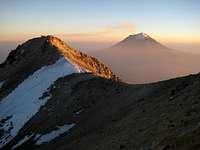
On our drive to Itza we saw nearby Popo (closed because of volcanic activity)
blow some giant puffs of smoke into the air. It was quite the spectacle. We
approached the peaks from the east and picked up our permits at the ranger
station, which sits between Pop and Itza. These peaks are located in a national
park. We reached the trail head and got started about 11am. Initially we planned
to hike up to around 16,000 feet and bivy, then finish the rest of the peak the
next day. Our driver stayed at the trail head and slept in the van awaiting our
arrival the next day. I had a feeling that this could be done in a day, even
with the 11am late start. So when we reached the 16,000 feet hut we cached our
overnight gear. The temperatures on this peak were much warmer, and the style
greatly different than Orizaba. Orizaba was basically straight up. This climb
went up, but it meandered around rock towers. Then after about 16,500, feet it
went up and down many times as the route traverses this long mountain. Because
of time constraints and pace, my partner decided to wait for me at the rat
infested hut at 16,000 feet while I finished up. Little did I know that
there were two more glaciers to cross and many ups and down.
![Glacier on Itza]()
When I finally reached the summit crater it wasn't clear which of 3 points
was the highest, so I touched them all and found what is accepted as the high
point. Unlike in the U.S. there are no summit logs on these peaks, only crosses and
tons of memorials along the routes. I hurried back to my partner and reached him
just at dark. After telling me about the rats in our sleep area, we made the
decision to just push all the way back down in the dark via headlamp. The going
was pretty tough in the dark, particularly where the route crossed rocks or
dropped steeply, but nothing was ever too extreme. We reached our driver at 9pm
who was getting ready to crash at the trail head. "Mexico City?" he asked. We
made our way to a hotel in Mexico City after a long day climb and slept well in
the comfort of a real bed. In some ways I viewed Itza as a harder peak for us
given it's ups and down and the route finding challenges. It was also plain hot,
even at 17,000 feet.
Day 6
While in Mexico City we did some sight seeing in the day thanks to our
driver, and then on our last night went to a Mariachi restaurant and The Hard
Rock Cafe and King's Pub for some wild fun. We never felt unsafe in Mexico City
or anywhere in Mexico, thanks in part to having a driver. It was easily the best small
amount of money I've ever spent. Not worrying about logistics let us focus on
the climbing. In addition, it was easier to take in the culture and scenery.
Conclusions
1. Get a driver
2. Don't worry about safety
3. If your comfortable climbing on Mt. Hood, then the climbing style on
Orizaba will be no problem
4. If your altitude sensitive: Be aware of how you feel at Tlachichuca, and
how you feel at Sierra Piedra Hut- gauge it from there.


Comments
Post a Comment