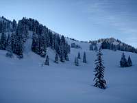
Intro & ascent to Ochsenkopf
It snowed a lot during week nr. 50 and when I checked the weather forecast on Wednesday a high pressure zone was proposed for northern Europe.
The result was very low temperatures right after fresh snowfall. Fog, mist and clouds built up in lower areas, but blue skies could be found in the mountains.
My goals were set up pretty fast: go for another one day solo ski-tour in Allgäu Alps on Sunday, my third weekend ski-tour in a row.
I picked out a two-mountain-tour which can be safely done even with a higher risk of avalanches (there had been a grade 3 proposal by the Bavarian avalanche service).
My route started at the end of the public road inside the Ostertal (1000m) and ascended up to Großer Ochsenkopf (1662m) first. From the summit a first ski decent lead back into the valley. After skiing half way down back into the valley the route went up again and ascended to Rangiswangerhorn (1615m). From the top of Rangiswangerhorn a nice ski decent lead down all the way into the valley and back to the end of the public road where the route started. The total altitude difference for this route was about 900 meters, so this can be seen as a nice and easy tour for one day including the 460km drive from my home to Allgäu and back again.
I started kind of laid back with a comfortable breakfast and left my home in Gerlingen about 10:30. Even it was cold outside there was actually no snow in the Stuttgart area, but I knew from studying some webcams there was a lot of snow in the Allgäu Alps all the way down into the valleys waiting for me. I drove through a cloudy Germany that morning, but coming closer to the Alps I could witness the clouds were hanging low, so the mountains were in the sun.
The Allgäu Alps welcomed me with a lot of white powder and glooming light was streaming through the mist. The higher I got the more the sun was shining.
My drive to Gunzesried was fast that Sunday and I reached the parking lot within 2hrs. at about 12:30. Thanks to the intelligent traffic system at German highway number 8 between Stuttgart and Ulm, that cancels all speed restrictions if the amount of cars is low on the highway. We should have that everywhere on German highways!
One more time the weather was totally different than at home. I guess many of you know that feeling looking out of the window at home starting to think, “it can’t be fun to go outside today”. Once you overcome your disbelief and witness totally different conditions in the mountains it always gives a special drive.
I had that special drive immediately after getting out of the car. Minus 14 degrees Celsius, the sun was shining, the air was dry and everything around was a winter wonderland.
It took another 30 minutes to get my gear ready.
After leaving the parking lot I crossed the bridge to get to the eastern side of the valley.
A first steep hillside was gained and after that the route mainly followed a summer track used by mountain farmers.
I could witness a good track going up to the left directly to Rangiswangerhorn but my first goal was Großer Ochsenkopf, so I followed the valley in a slow elevation heading southwest.
I took a look back once in a while because the clouds were floating slowly deep into the valley behind my, looking like some kind of cream.
I overtook a couple with snowshoes passed some closed summer-farmhouses and overtook another couple with touring skis and really enjoyed the fantastic scenery around.
The only thing bothering me a little was the strong cold once the route went into the forest leading to the result that the sun was not warming me anymore. The track was of small elevation at that passage so I took up some more speed, but still didn’t really get warm.
After something over an hour I reached a crossing where one track went up to the left leading to Rangiswangerhorn again.
My track turned to the right and I came by another closed summer-farmhouse.
The last 250 meters were steeper terrain and I welcomed that, because I got warm again.
Closely before reaching the summit an older couple came down skiing. I greeted one of them and we exchanged some words about this fantastic day. He had that shine in his eyes that people get when the snow is powdered.
The glooming continued on my last meters ascending to the summit. It was for sure occasional, but the sun was reflecting directly in the summit cross coming from my direction.
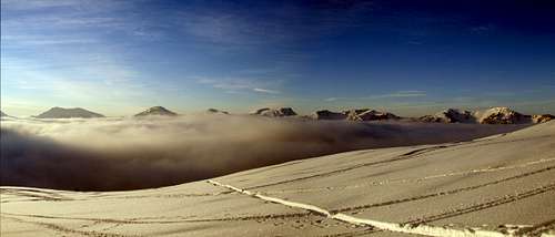
The summit offered a fantastic panorama all around the Allgäu Alps. I could see the higher mountains in the south and a sea of clouds swashing slowly into the valley to the north.
When checking my GPS I found out that the extremely low temperatures killed the batteries. It must have had shut down some time ago.
I took some pictures, swallowed two Power Gels, but couldn’t drink anything, because the water in my backpack was totally frozen.
Ascent to Rangiswangerhorn
Then I started my ski descent back into the valley. The snow was fantastic and by that time the clouds covered nearly the whole valley. I was diving into the clouds and pretty fast back at the crossing to ascent my second goal, the Rangiswangerhorn.
Ascending again I pushed the right foot down, because I was emerging from clouds and wanted to see the sun again.
At a certain stage the forest thinned out and I could see some trees further up to the right already touched by the sun.
I reached a plateau without trees and had a spectacular view over the valley filled with clouds. The mountains on the other side of the valley peaked out.
The sun was going down and touched the whole scenery into a warm and soft light. The snow was so fine that every little structure was reflecting in the sun.
I reached a saddle that opened another spectacular view to the east into the Oberstdorf valley.
From there it was not far anymore and my route followed the ridge on the last meters to the summit.
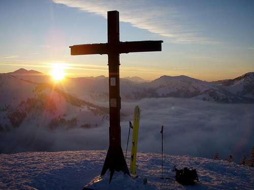
I was alone on the summit of Rangiswangerhorn at about 16:00 and the sundown was just about to happen.
I took another panorama and focussed the sundown and then prepared for the final decent.
Detour in winter wonderland
I didn’t know the way down exactly because I had not skied down from Rangiswangerhorn into Ostertal before. Besides the not working GPS I had a paperback guidebook with me, that included small maps with the routes around.
I studied the way down on that small map and could see, that the route should go down a small passage to the north turning left to the west, but always staying close to the forest on the left side (from going down). To the right side a huge area was free from trees, but that was not the right way because it led into the wrong valley.
I could see some tracks and felt pretty safe after reaching a small closed down hunting lodge which I remembered from looking at the guidebook’s map just some minutes ago on the summit.
The lodge was on a small crest and I could see ski tracks go down to the right of the crest. I was thinking about the map in my head and remembered in the guidebook’s map the route was drawn going down to the left of the lodge.
Then I made the mistake of the day. Instead of taking out the guidebook again and checking the situation I trusted the ski lanes. My trust was amplified by the fact that there were not only lanes going down but also a good track from many skiers coming up. I remembered the first track I could see right after I started from the parking lot that was going up directly to Rangiswangerhorn and drew the conclusion: “this must be it”.
Swinging down was enjoyable again and I was drawing some fresh lines but then suddenly stopped to find myself in a miserable situation. All ski lanes ended at a certain point, the forest got dense and the conclusion was coming to me within a second: this was a trap and many others fell into it before. Everybody going down here before had to find out this was a one way tour forcing to return back up. That was the reason for the good lane: all those people produced it, when turning around and going up again. I misjudged that from the top.
I had to make a decision. Turn around like all others and ascend 300 meters of altitude again? It was getting dark fast and I didn’t like that idea, because once I would reach the hunting lodge again it might be totally dark and finding the right track could be hard under those circumstances. The right way down couldn’t be to far way from here, I thought. It should be somewhere to the left.
Since there was about one meter of snow cover I decided to give it a try, skiing through the forest and doing something different than everybody before. Maybe my decision was consolidated by the fact, that following the lanes had been wrong and I didn’t want to follow everybody else for a second time leading to something wrong again.
I am a pretty safe skier, so from a technical point of view crossing the forest with so much snow was not a problem.
After giving it a try to the left the forest opened up and I was right on top of a small valley with a little stream in between. Now I knew: going cross country had been the second wrong decision in a row. Some adrenaline was pumping through my veins now, because in this time of the year it’s getting dark pretty fast after the sun went down in southern Germany.
Outside temperatures were way down below minus 15 degrees Celsius and could maybe drop under minus 20 degrees Celsius during the night.
I was alone, had nothing to drink, just a small bivisack with me and should better make it back into civilisation pretty fast.
I worked on my mind to calm me down and told myself: “no problem, it can’t be far back to the road from here anymore, just no more mistakes and don’t hurt yourself!” I remembered packing my headlights into my backpack in the morning and quickly had the idea that those headlight batteries might also work with my GPS.
A minute later I had 9 satellites in my display and knew where I was. My Garmin GPS has a 2 GB Micro SD with topographical maps including the whole Alps installed.
A short analysis later I knew I was in a wrong valley, but this was not the biggest problem, because crossing the valley to the left with loosing some minor elevation would lead into the right direction. From where I was the distance to the road was about 2 kilometers.
I skied down the tree free valley and crossed my first stream that day. It was a comfortable crossing, because the stream was kind of small at that passage, but it shouldn’t be the last one on that day.
The deep snow that I loved so much shortly before now made everything harder than needed. After crossing the valley I had to dive into dense forest again. This started to take all my reserves, but I took a calming down look at the GPS display once in while what showed me, I was heading in the right direction.
It was nearly dark now and I could only see the surrounding but no details anymore. After routing and scrabbling myself through another forest I came to another area free from trees. I skied down the area “blind” into the dark of the night which was an interesting experience and demonstrated me that skiing skills work by intuition more than from what someone sees.
Coming to the end of that section another belt of forest had to be crossed. It was really dense this time and I thought about taking of the skies and re switching the batteries back into my headlights.
My intuition told me to look to the right of the forest belt, before loosing time again and I was lucky. To the right there was a small passage through the forest probably used by lumberjacks in the summer. I fumbled my way down that track still keeping the GPS going. The track turned here and there and after some more going down I could see a light down in the valley. The third tree belt was crossed and right before me were meadows leading down and covering the last distance into the valley.
I calmed down and just got sucked up by one more river crossing. This time it was a wider one than my first challenge. It was easy to get down, but definitely not easy to come out on the other side of the notch. Lose snow broke down and I kind of rolled myself out using the poles to help a little bit.
When I reached my car it was totally dark. I had my mobile phone with me all the time, but didn’t turn it on, because I had not been in real emergency at any time. Maybe I didn’t want to find out that there might have been no service.
Back at the car in the middle of the valley I turned it on to witness there was some minimal service of one connection bar in the display. I called my wife. She already had been seriously worried about me and so I told her, “I am fine and will be home in two hours”. Then I found something to drink inside my car that had not been totally frozen. Good thing after feeling thirsty for some hours.
Conclusion: don’t follow any tracks if you don’t know where they go to! Trust on yourself and check all information before making decisions!


Comments
Post a Comment