Introduction
![Himmelhorn (2111m)]() Himmelhorn Himmelhorn |
I am
not a skier, in fact I actually kinda hate the sport and so I generally avoid the mountains in the wintertime. “Hüttenzauber” (binge drinking) or loud Volksmusik echoing across ski runs and mountain slopes, overcrowded parking lots and traffic jams during the approach to the ski resorts – I can live very well without them. Thus, I rarely see mountains covered with snow and ice unless it is a glacier which survived the whole year well into early autumn.
Yes - I do have my prejudices.
But then – late last year – the management of our company decided to stage an incentive team building event in Oberstdorf – in the middle of the Allgäu Alps on March 8th and 9th. Obviously I didn’t complain and hoping for a decent weather forecast I booked an additional day for whatever activity might be called for. There had not been much snow in the German Alps so far and I thought I might get a chance for a good hike – I was dreaming of the Rubihorn – Gaisalphorn ridge traverse and an ascent along the Nebelhorn west ridge. But things turned out quite different – though the weather couldn’t have been better.
The following TR mainly deals with Sunday morning, March 11th 2007 but in the context of the whole teambuilding weekend.
Anticipation
More than a week before the event weekend I started to hunt down favourable weather reports but all I could find was acceptable weather for Friday, snowfall (ugh) on Saturday and a cloudy Sunday. Judith , my girlfriend, who had planned to come for two days, drew the bad weather option and decided to stay at home. I agreed with a colleague of mine to pick him up on Thursday morning and drive the 480km to Oberstdorf together.
Say what you will – the weather on Thursday was perfect. We had a nice quiet drive without any jams – very rare on Germany’s motorways. Since we had started at 7 a.m. we slipped by the worst spots right after the morning rush hour and were a bit faster than the GPS system had predicted. But as we got closer to the Alps, clouds started to appear in the south – and as we entered the Iller Valley, which leads to Oberstdorf, the sky was overcast. At Sonthofen the clouds had dropped to about 1000m, so that none of the mountains, not even the lower ones of the Allgäu prealps was visible. As we closed in on our destination it started to rain and mist and fog obscured any view. Though I had been to the area before, it had been in the early 1990s, and I couldn’t remember very much anymore – certainly not in the fog.
But the forecasts had called for a decent, but cloudy Friday and the reminder of Thursday was reserved for a meeting anyway. We learned about ITIL and IT governance, I rapped up a recent project and then it was time for food and drink. Little food but lots of drink. In fact way too much …
Igloo Building
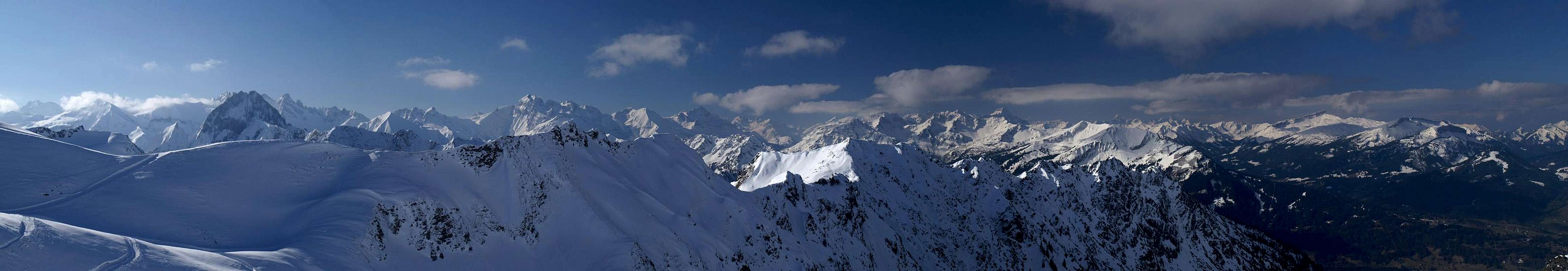
IfenspitzenRauheckKreuzeckKl. HöfatsGr. KrottenkopfHöfatsKrottenspitzenFürschießerKratzerTrettachspitzeHochfrottspitzeBockkarkopfWilder MannHohes LichtRotgrundspitzeLinkerskopfBiberkopfHüttenkopfSeeköpfelSchattenbergGrundköpfeSchafalpenköpfeKemptener KopfWiddersteinKanzelwandFellhornLechquellengebirgeWallmendinger HornHoher IfenGottesackerwände ![]() |
The agenda for Friday morning called for a team event – igloo building. There was no snow left in Oberstdorf itself but we were shipped by car and cable-car to the ski runs south of Nebelhorn – to an elevation of approximately 2000m. Decent weather? What an understatement! It was a perfect day – clear skies (thanks to the rain the day before) with just the right amount of picturesque clouds. Every mountain within a range of 100km was visible – and you may well suppose that I spent much time shooting pictures before learning the craft of iglooing.
![Team Igloo in front of Östlicher Wengenkopf]() Igloo and Östl. Wengenkopf
Igloo and Östl. Wengenkopf
In winter the Oberstdorf community and cable-car operators clear a “winter hiking trail” – 30 minutes to each side of the cable-car station “Höfatsblick”. We took the southern branch and decided to build our igloos near its end at Zeigersattel – in the shadow of the small but impressive north face of Hüttenkopf (1942m). I climbed the remainder of the trail to Zeigersattel and from there headed out on the kife-edged ridge of Hüttenkopf. Much exposure and a gorgeous view – but then I returned and took my share of the igloo construction. After three hours two igloos were finished and we returned to the cable-car for a hearty lunch. We were left on our own for the remainder of the day and I roamed up and down the blasted winter hiking trail. Far too short imo – but I managed to climb a second smaller summit, Zeiger (1995m), a eastern neighbour of Hüttenkopf, far less impressive and much easier to get to without proper equipment. And it offered good views to the east, which I hadn’t been able to see the hours before.
Time for food and drink – much food and much drink this time…
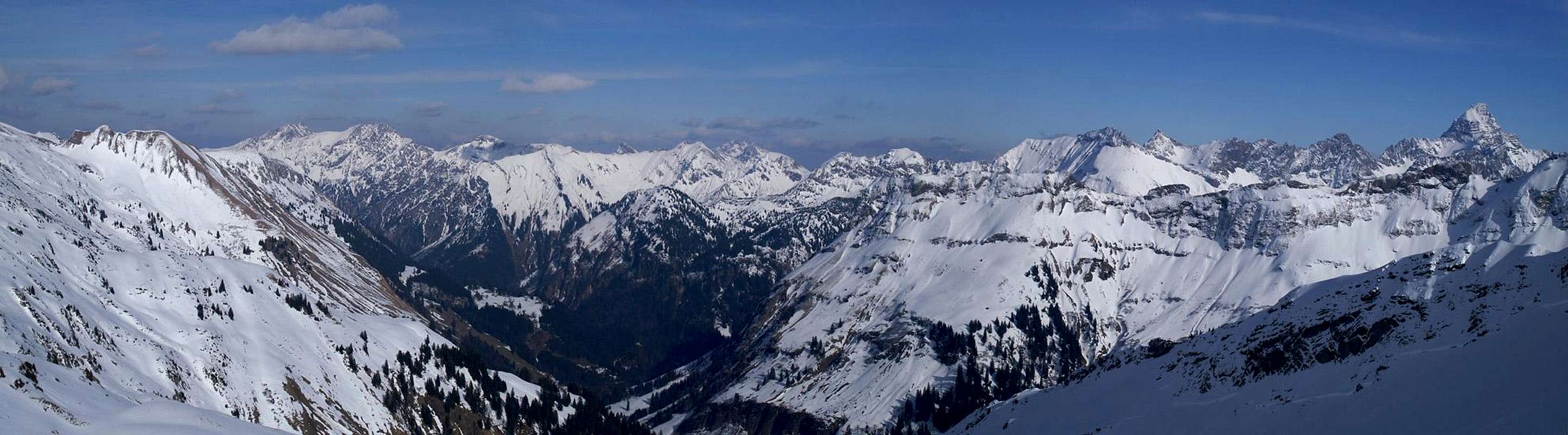
LaufbichlkircheGaishornRauhornKugelhornKnappenkopfLellachspitzeKirchendachKastenkopfRoßkopfLahnerkopfKälbelespitzeGiebelLärchwandGlasfelder KopfKesselspitzeFuchskarspitzeKreuzspitzeHochvogel ![]() |
Breitachklamm
![Breitachklamm]() Breitachklamm
BreitachklammNext morning again another team building session – this time it was ice stock sport (a kind of curling) without ice but with lots of snow coming down on us from above. We spent an hour but then the first colleagues left for home. By lunchtime only nine were left, thereafter only two – our sales guy who wanted to go skiing for the rest of the week and poor old Gangolf who wondered were the heck he should hike to in that kind of weather.
I decided on Breitachklamm, one of Europe’s most impressive canyons. The Breitach River, which runs out of Kleinwalsertal Valley has cut a deep slot canyon out of the chalk and limestone of the Allgäu mountains. A secured hiking trail leads through it negotiating the narrow overhanging passages on bridges, always protected by railings. It might not appear like much fun but it’s a good way to spend a rainy (or snowy) day. You have to spend €3 but luckily on Saturday afternoon there were no crowds.
The canyon is very deep and very narrow. You can touch both walls with your fingertips in te narrowest passages but above you there are still some 200 or 300m of vertical or overhanging rock left. Walking through the canyon often seems like walking through a cellar. There’s only little light and in some places you can’t see the sky in any way. On a day like this lots of rain and snow water drips down on you and I had a hell of a job to do to protect my camera.
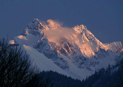
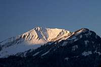
In the end I wriggled my way out of the gorge and headed back to the hotel. Weather was already getting better and someone had promised a picture perfect day for tomorrow. By the time I returned the sun was setting in the west. Out of my hotel room I took two shots of Trettachspitze, Mädelegabel and Hochfrottspitze , mountains on the Austrian – German border in the south of the Allgäu Alps. There was more to come the next day.
![Alpenglow on the Allgäu Alps Trinity]() Alpenglow on Trettachspitze, Mädelegabel, Hochfrottspitze
Alpenglow on Trettachspitze, Mädelegabel, Hochfrottspitze
And again it was time for food and drink – much food and little drink this time…
The Wonderland
Due to the snow my plans for the coupled ridge traverses from Rubihorn to Gaisalphorn to Nebelhorn had to be cancelled. I decided to take a shot at Älpelesattel, a saddle between the Oytal and Dietersbachtach Valleys. It is less than 1800m high and after our iglooing experience I thought I might have a chance to struggle over it. I knew I was not equipped for any serious winter activity and planned to retreat as soon as circumstances required it.
FürschießerKratzerTrettachspitzeHimmelsschrofenLinkerskopfHochgrundspitzeHochrappenkopfGrundköpfeSchartenkopf ![]() |
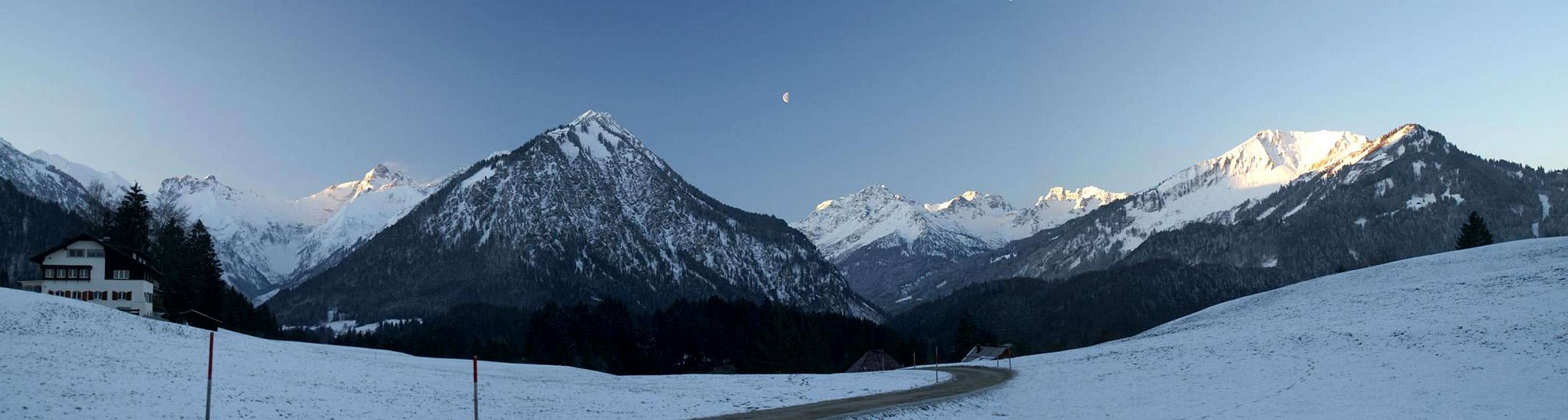
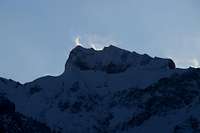
I drove to downtown Oberstdorf early in the morning, way before sunrise. The night had been clear and now it was a frisky morning, which promised unparalleled views. I headed out towards Oytal Valley and as I cleared the forests around Oberstdorf and reached the first spot with a view the sun decided to rise on the mountaintops to the south. A magic moment, even as the moon was setting behind Himmelsschrofen. I could look down all the way through both the Trettach and Stillach Valleys to the mountains on the border ridge between Austria and Germany. One after the other they started to glow brightly while the valley floors remained in deep shadow. I was moved very much.
![Sunrise on Trettachspitze]() Trettachspitze Trettachspitze | ![Grundköpfe]() Grundköpfe Grundköpfe | ![Himmelschrofen Moonset]() Himmelsschrofen Himmelsschrofen |
![Sunrise on Kratzer]() Kratzer Kratzer | ![Hammerspitze (2259m) and Hochgehrenspitze (2253m)]() Hochrappenkopf Hochrappenkopf | ![Linkerskopf]() Linkerskopf Linkerskopf |
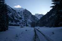
But I decided to move on – if I wanted to reach Älpelesattel I had to stay on time. A sign on the outskirts of Oberstdorf had claimed 4 hours! And here I was – certainly having to struggle through snow without equipment. I couldn’t dare to lose too much time or I would be forced to retreat. So I entered Oytal Valley – and immediately the fierce easterly winds forced me to cover my head. Since I was heading in the direction of the rising sun, the mountains at the back on the valley were only visible as shadowy shapes. Spindrifts on the summits of Schneck and Großer Wilder indicated strong winds on the mountaintops. I reached Oytalhaus, the restaurant in the centre of the valley. Still nothing was moving in the vicinity – it was still not yet 8 a.m. I headed on towards the back of the valley and now there were only the tracks of two men and one dog to indicate the direction.
![Schneck]() Schneck Schneck | ![Oytal Valley]() Oytal Oytal | ![Hüttenkopf]() Hüttenkopf Hüttenkopf |
![Schattenberg]() Schattenberg Schattenberg | ![Schneck]() Schneck Spindrift Schneck Spindrift | ![Höfats and Seilhenker]() Höfats and Seilhenker Höfats and Seilhenker |
However, after a couple of hundred metres the tracks stopped near a bench. Now I was left to my own wits – and rabbit and fox tracks, which both led in the correct general direction. At Untere Gutenalm I lost the last indication of the dirt road which was supposed to be hidden beneath the snow. I had to cross a wild halfway frozen creek and then got lost. Luckily I could see the road further on up in the back slopes of the valley so I tried to guess how to get there. I was successful and finally reached the Stuibenfall waterfall. By the time I was struggling through harsh snow, covered by a 6 inch layer of new snow. I was doing well for the circumstances but it started to dawn on me that I would be tired out before I reached the end of the current stage Käseralpe at 1400m.
![Kleiner Höfats]() Kleiner Höfats Kleiner Höfats | ![Höfats NW Summit]() Höfats NW-Summit Höfats NW-Summit | ![Höfats]() Höfats Höfats |
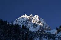
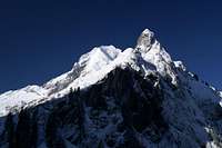
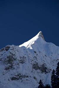
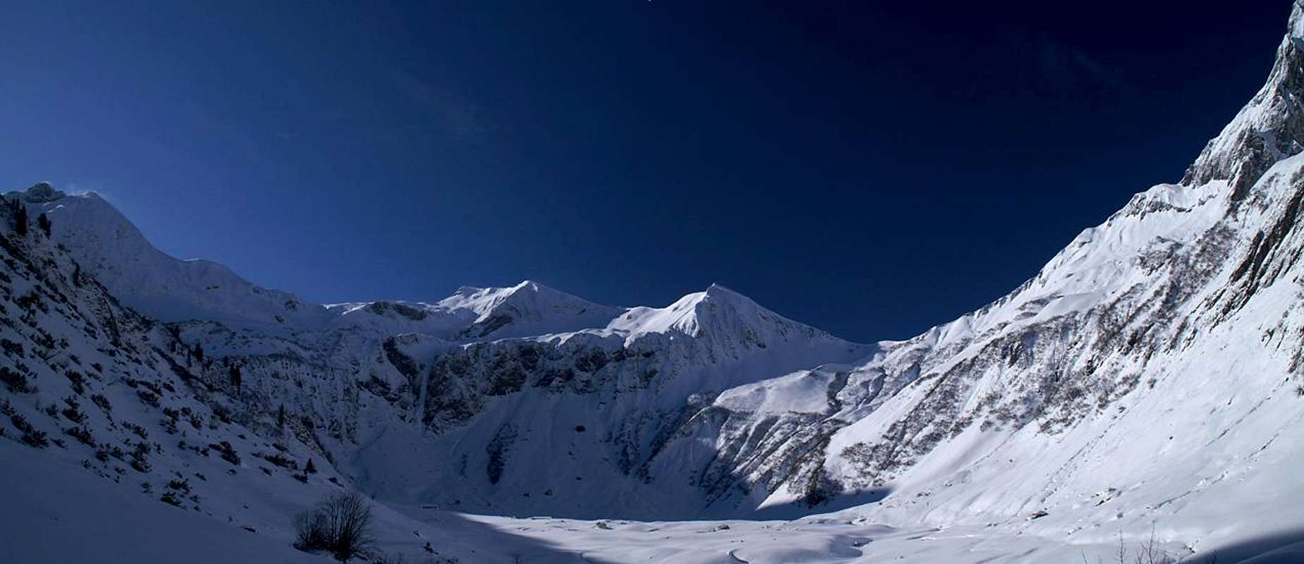
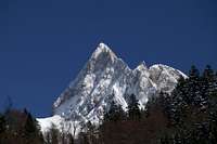
I had promised myself that I would definitely go as far as the Alpe Building before turning around – there was supposed to be the support road somewhere around here. Off and on I could distinguish the road, especially on the switchbacks which lead from the valley to the Alpe. As I got closer to the valley end the views got more and more breathtaking. Two pillars – Himmelshorn (2111m) to the north and Seilhenker (1791m) to the south guarded the entry to the high, plateau-like cirque of Käseralpe. And Schneck (2268m) to the north and Höfats (2258m) to the south added to that sentinel impression. The sky was a
deepblue, so deep that it seemed to turn to black above Höfats.
I reached the “meadow” plateau around Käseralpe – it was covered in big, beautiful mounds of fresh snow. So big, that after a few steps in the direction of the main building I broke through the lower level and one of my legs disappeared altogether. I managed to struggle out of the hole but at that instant I knew I wouldn’t reach the saddle. Nevertheless I headed on for several hundred meters to get to the building but after some more breakthrough experiences I decided to retreat. Moreover the sun was just now circling the Rauheck summit and immediately started to warm up the valley. I didn’t want to think what it would be like to break through 2m of wet snow and quickly got back on “safe ground”.
![Schochen (2100m), Himmelhorn (2111m), Schneck (2268m)]() Schochen, Himmelhorn Schochen, Himmelhorn | ![Himmelhorn Spindrift]() Himmelhorn Spindrift Himmelhorn Spindrift | ![Käseralpe]() Käseralpe Käseralpe |
![Höfats]() Höfats Höfats | ![Oytal Valley]() Oytal Oytal | ![Schattenberg]() Gutenalpe Gutenalpe |
The retreat was every bit as beautiful as the ascent had been. In the few hours the sun had moved quite a lot so that now many of the shadows had vanished from the floor of Oytal Valley. A party of tour skiers came up as I had almost reached the valley floor again. They must have been wondering were I had been coming from but I’m sure they had the same destination I had had (only with more appropriate equipment) and they surely would find out soon enough. As I closed in on the Oytalhaus Restaurant hordes of hikers came the other way. There was a public feeding of wildlife animals and lots of cameras were installed on their tripods. Obviously I was back in civilization and I didn’t stop for the “show”.
Instead I returned to Oberstdorf, which I reached around noon. This tme the food consisted of two old rolls and the drink was a liter of sparkling water. Add some crisp fresh air and I will prefer this kind of food and drink over any other in the world!
Trettach Valley
![Trettachtal]() Trettachspitze above Trettachtal Valley
Trettachspitze above Trettachtal Valley
Now here I was – at noon in Oberstdorf – what was I supposed to do with the rest of the day? I had toyed with the idea to drive to dome cable-car lift, go up and enjoy the views. But I couldn’t stand the idea of being enclosed with hordes of ski tourists. I could try to get up to my saddle from the other side, through Dietersbach Valley. In hindsight I think it might have been possible since here were the southern and western sides of the saddle. Well, I didn’t want to be frustrated another time and honestly, I was already so tired that a climb of 1000m just didn’t seem feasible.
Therefore, I decided to hike out the Trettach Valley, which I could see from the bench I was having lunch on. In the back of the valley there is a little village, called Spielmannsau, where I hoped to get some coffee and maybe an Apfelstrudel. But I was not the only one who had this idea. Again hordes of people were on the road to Spielmannsau and I amongst them. Every bar, café, restaurant was packed full and I said goodbye to my strudel. I reached the village but refrained from heading out to the hamlet of Oberau, which is some 4km to the south of Spielmannsau. Now it was 1:30 p.m. and I started to head back slowly. I was hurting all over from this morning’s struggles and I would certainly
not take another hike today. Still, all restaurants were packed, though here and there were free tables in the shadows. I was feeling cold already and headed on.
![Spielmannsau]() Spielmannsau and Traufberg Spielmannsau and Traufberg | ![Höfats West Face]() Höfats West Face Höfats West Face |
When I finally reached Oberstdorf again I had hiked 35km (22miles) and climbed 1500m (4500 feet). My back and my left leg (which had broken through the snow on Käseralpe) were hurting and the only thing left to do was drive back home – another four hours to go. I took a rest and now my refreshment was restricted to the remaining water in my Sigg bottle.
From my viewpoint on the “Festwiese” I could see the Rubihorn – Gaisalphorn Ridge beautifully with Nebelhorn in the back.
Still, I wish I had been able to climb it…
![Rubihorn, Geißalphorn, Nebelhorn]() Rubihorn, Geißalphorn, Nebelhorn
Rubihorn, Geißalphorn, Nebelhorn


Comments
Post a Comment