A Wet Morning
My eyes popped open a few minutes before 6am and I stepped outside to look at the weather. The rain had stopped, but the clouds seemed socked in as they scudded across the high cliffs surrounding the Lone Eagle Cirque. Lone Eagle seemed even more intimidating in person as the fog shrouded the mountain's high flanks in secrecy. I figured that as long as the rain wasn’t falling it was worth at least starting up Solo Flight. We (3 of us total) gathered our things that had hastily been stuffed under a tarp the night before during the downpour. We had a quick group prayer and were on the trail by 7am.
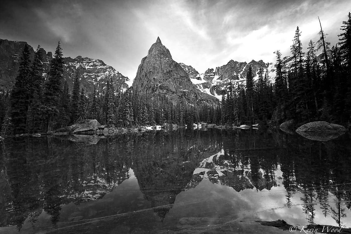
![Lone Eagle Reflection]() Lone Eagle Reflection
Lone Eagle ReflectionOn the Trail
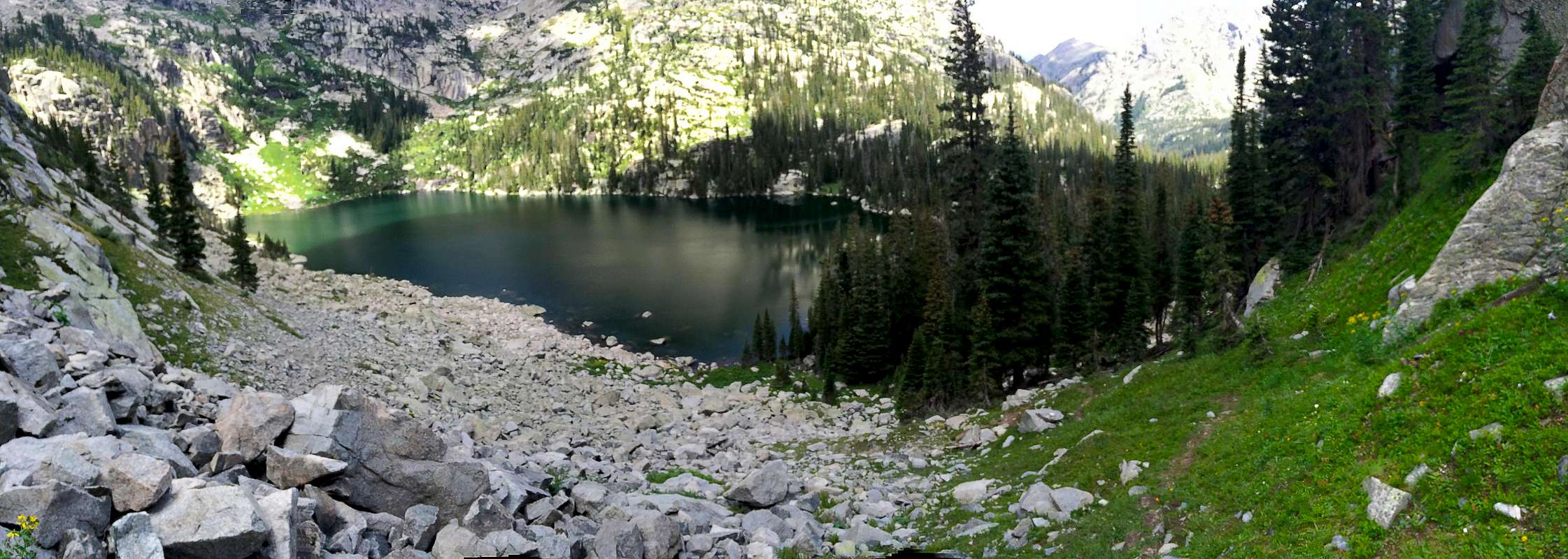
From our tents at site 5, we followed the trail that led toward campsites 6&7. The route description said to leave from campsites 7/8, even though different trails led to site 7 and site 8. Nevertheless, we found a faint trail beyond site 7 that bordered the south side of Crater Lake (the side closest to Lone Eagle). After a minute or two of hiking along slightly trampled grass, we came to a clearing where the dramatic north face of Lone Eagle soared in front of us. To our right was Crater Lake and to the left was a small boulder field. Pausing for a second to admire the shear face, we turned left and headed up the boulders. The route info that I had found said to stay close to the face, but we quickly found a climber's trail on the opposite of the boulder field marked by cairns. The trail dodged in and out of the boulders, climbing steadily toward a patch of open, grey sky between the rock face and some trees rising out of the valley. After working our way over the apex of that hill, we followed a good climber's trail that angled slightly right through a grass ledge system toward Triangle Lake.
![Lone Eagle: Crater Lake]() Lone Eagle: Crater Lake
Lone Eagle: Crater LakeThe trail was easy to follow, but wet...and I mean wet! The rain the night before and lack of sunshine during the first few hours of the morning had made the ledges very slick. We continued hiking through beautiful knee-high wild flowers that, for the time being, seemed bent on our destruction. The progress was slow, but we steadily gained elevation on the valley floor to our left. For some reason I thought that we would quickly reach the saddle with Triangle Lake, but this was not the case. I soon realized that Triangle Lake was above us and tucked behind a headwall visible at the end of the cirque.
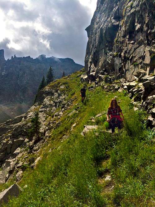
![Lone Eagle: Grassy Ledge]() Lone Eagle: Grassy Ledge
Lone Eagle: Grassy LedgeThe whole basin was beautiful and the quick moving fog added an epic and ghostly sort of feel to the day. We continued prodding south, away from the summit of Lone Eagle, up the grass ledge until the obvious triangle lake saddle appeared ahead of us. Here the cairned trail hopped over some more boulders and stayed close the east flank of Lone Eagle. Once we finally gained the saddle, Triangle Lake came into view (a beautiful turquoise alpine tarn) as well as a gorgeous view of the valley below. Here most route descriptions I found said to turn left as soon as the lake became visible. This is one possibility and on the way back from the summit we found an un-cairned weakness in the cliffs. However, on our ascent we found an easier, more obvious (and cairned) route slightly further up the ‘ledge’; beyond the saddle by maybe a tenth of a mile. More obvious being a relative term, as this was the only place on the whole route where we soon took a wrong turn.
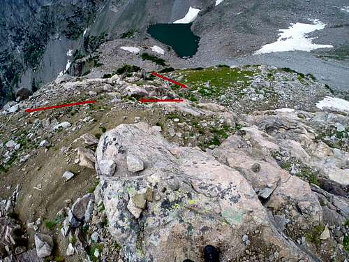
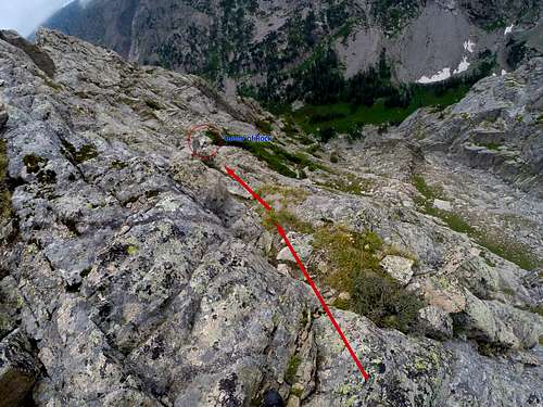
Above Triangle the ledge angled slightly more south and west. Here, we eventually reached a point where obvious 3
rd class climbing was head of us. Initially, we followed a weakness in the cliff bands that led further southwest (class 3). For the first few hundred feet the climbing wasn’t too bad, but soon we started grappling with a 45-degree grass wall and the wetness got the best of us. Quickly we realized this was going to get ugly, so we turned around and spotted the correct route below us by about 50 feet and further to the north (See the picture below for the correct route).
![Lone Eagle: Leaving the First Ledge]() Lone Eagle: Leaving the First Ledge
Lone Eagle: Leaving the First LedgeWe carefully tried to control our slipping and falling as we worked our way off the steep grass slope and back on route. This was possibly the most difficult section of the climb and taught us a valuable lesson: any step off route above Triangle Lake will be the crux of the climb. From where we took the wrong path, the real route was directly to the northwest (instead of southwest) (climbers right) and involved about 40 feet of 3
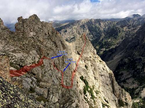
rd class climbing.Once we were back on route we followed the obvious, large and rocky dirt ledge, doing an ascending traverse toward Lone Eagle (north). This part of the climb was easy class 2 climbing with the occasional 3
rd class move as we climbed higher on the ridge. Soon a north-facing opening in the rock appeared in front of us. (From this opening the rest of the route to the summit could be viewed see the picture below) The cairned trail continued toward this notch and then darted left toward a large notch (from now on referred to as the first notch). Here we climbed through the first notch and worked our way onto the west flank. The view from the other side of the ridge was dramatic, with a Patagonia-like landscape rising out of the south. We scampered across the west face for a short few steps and made an
immediate right through a second notch that was guarded by a chalkstone.
The Upper Route
![Lone Eagle: The Route]() Lone Eagle: The Route
Lone Eagle: The RouteFrom the chalkstone an airy step led to a tricky 3
rd class down climb. Here the whole rest of the route was in view and we knew things were about to get more difficult. The weather still left me slightly unsettled as I watched some clouds rise beneath me. We proceeded north toward the summit slowly picking our way through the tricky terrain to the infamous (I don’t know if its really infamous but we will go with that) down-climb. The down climb was somewhat difficult to spot, but really no more difficult than the rest of the climb after the second notch.
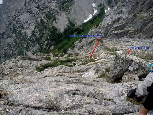
![Lone Eagle: Above the THumb]() Lone Eagle: Above the Thumb
Lone Eagle: Above the ThumbThe key was the ‘thumb of rock’ referred to in two other Summitpost TR’s. From the point where the down climb has to begin a large boulder blocked easy access to our north and immediately below us to the left was the ‘thumb of rock’ with a cairn on top. At this point we decided to rope up since the grass was still wet, the skies still cloudy and I had already carried 2 half ropes and a light rack all the way from the car (no use wasting my effort).
![Lone EagleL The Downclimb]() The Downclimb
The DownclimbSince we were on-route it was pretty unnecessary, but it did provide peace of mind for our wet feet. The target of the down climb was a large ledge at the bottom, larger than any others visible. I was the first one down and climbed directly straight to the ledge. Once I got to the bottom though, I noticed a sneaky little path that eased the difficulty substantially (see the picture below and the route picture from the small notch). About 2/3’s of the way down the downclimb (25 feet or so from the bottom of the ‘thumb of rock’) a small ledge is reached.
From here turn south (away from the summit) and follow a ramp that does a u-turn (3rd class) before bringing you onto the larger ledge.
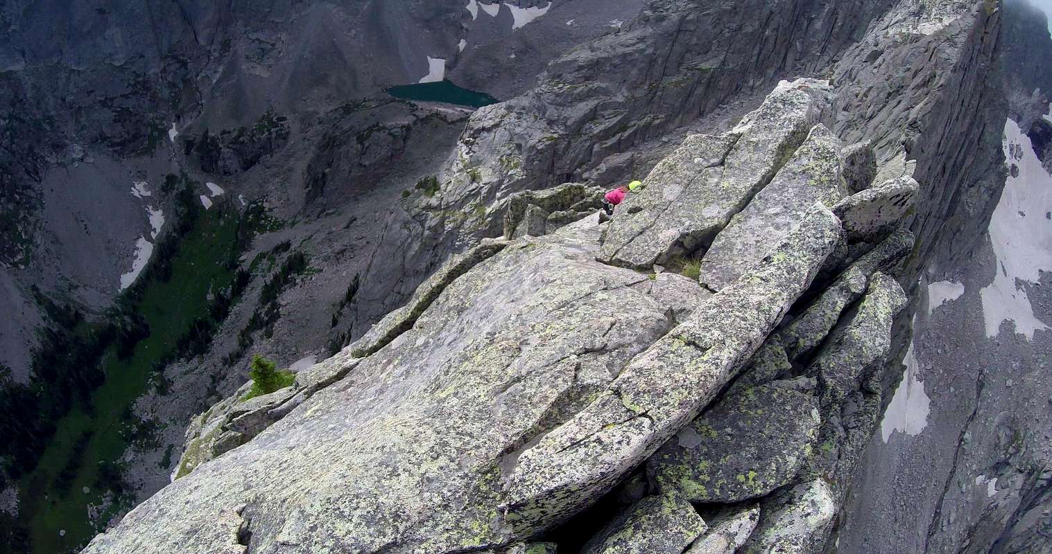
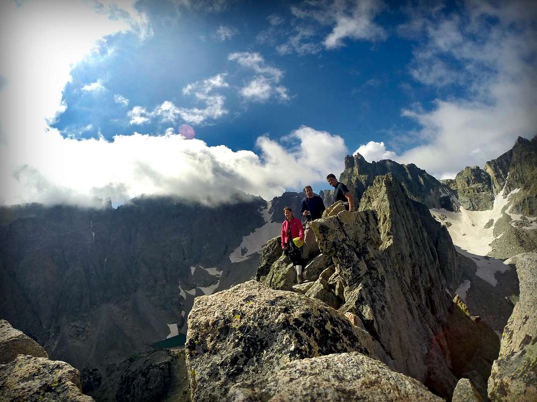
From here the route was pure fun with easy route finding (Class 3). It reminded me of a more fun, more exposed, and less crowded version of the homestrech on Longs Peak. Completely solid rock! Gaining the summit ridge was the best thrill of the whole climb, where we tiptoed along the two and a half foot ridge to the pin point summit. On the summit we watched as the clouds continued to hustle by, some blowing up from the valley floor, others encircling the two mountain cirque’s divided by the summit of Lone Eagle. It was awe-inspiring and eerie all at the same time. I was praying that the skies weren’t about to open up as we all quickly signed the summit register (Colorado, Texas and Hawaii) and enjoyed some snickers bars (you just need something more than a cliff bar on the top of a mountain like that). From our tent it had taken us about 3 hours. As we snapped some pictures (and obligatory hero shots) on the summit the sun started peaking out.
![Lone Eagle: From the Summit Ridge]() Lone Eagle: From the Summit Ridge
Lone Eagle: From the Summit RidgeBy the time we started down the sun was out for good and made the way back much easier; praise the Lord. (A rainstorm up there would be a nightmare). We made quick work of the 4th class section on the way back, forgoing the rope. After we climbed back through the two notches, I took some time to admire the route and beautiful mountain. It truly is a gem. We made quick work of the way down arriving back at the tent at noon, 1.5 hours after we left the summit. The backpack out was a slog, but a beautiful one with high spirits. A successful solo flight, one of the best summits Colorado has to offer!
![Group Summit Pose]() Group Summit Pose
Group Summit Pose
Comments
No comments posted yet.